Cullman County sits in north-central Alabama, where the I-65 corridor around Cullman, Good Hope, and Hanceville contrasts with the winding shoreline of Lewis Smith Lake to the west and smaller rural communities to the east. A single road map only tells part of that story. This page brings the county boundary, major towns, waterways, and elevation together in four separate maps, and the same maps are available as four high-resolution A3 JPG files in one downloadable ZIP.
The county seat of Cullman is the easiest place to begin. I-65 and U.S. 31 run north-south through the central part of the county, while U.S. 278 crosses through Cullman and helps connect the western lake country with communities farther east. Once those routes are clear, the rest of the county becomes easier to place: West Point and South Vinemont lie to the north, Good Hope and Hanceville to the south, Berlin and Holly Pond to the east, and Fairview and Baileyton toward the northeast. The water and elevation maps then show why western travel and settlement look different from the central highway corridor.
Table of Contents
Cullman County location, boundaries, and main roads
Cullman County borders Morgan and Lawrence counties to the north, Marshall County toward the northeast, Blount County on the east and southeast, Walker County to the southwest, and Winston County on the west. The general county map places these neighboring areas outside the dark county boundary, which makes it useful for understanding direction before looking at individual towns. Cullman itself sits in the north-central part of the county, with South Vinemont and West Point above it and Good Hope immediately to the south.
I-65 is the clearest transportation feature on the map. It passes close to Cullman and Good Hope and continues toward the southern part of the county, creating a direct north-south route between the Huntsville and Birmingham directions. U.S. 31 follows the same broad corridor and continues through Hanceville. U.S. 278 provides the main east-west reference through Cullman, while Alabama 157 and Alabama 69 add connections toward outlying communities. Near the northeastern edge, U.S. 231 and Alabama 67 help orient the Baileyton and Arab side of the county.
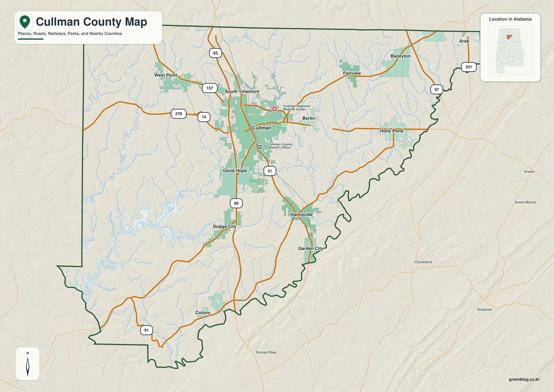
For a quick orientation, start at Cullman and trace the map outward. South Vinemont and West Point provide northern reference points; Good Hope and Hanceville mark the main southern corridor. Berlin and Holly Pond sit east of Cullman, while Fairview and Baileyton are farther northeast. Garden City, Dodge City, and Colony help fill in the southern and southwestern side. The value of this map is not simply the number of labels but the way roads, towns, and adjacent counties can be read together without switching between several separate sources.
How the major towns are distributed around Cullman
The city map simplifies the county to six ranked places: Cullman 19,319, Hanceville 3,270, Good Hope 2,574, Baileyton 1,039, Berlin 887, and Fairview 796. Cullman is clearly the largest center, but the map is especially useful for showing direction. Hanceville and Good Hope extend the populated corridor south of Cullman, while Berlin, Fairview, and Baileyton form a separate group to the east and northeast. That split is easy to miss on a long list of municipality names.
Good Hope lies close to Cullman and the interstate, making the two places appear almost connected at county scale. Hanceville is farther south along the U.S. 31 side of the county. By contrast, Fairview and Baileyton are removed from the interstate corridor and depend more on local and state roads. Berlin sits between Cullman and the eastern group, so it works as a useful midpoint when reading the map from west to east. Neighboring county labels around the frame also show which communities sit closer to Morgan, Marshall, Blount, Winston, or Walker County.
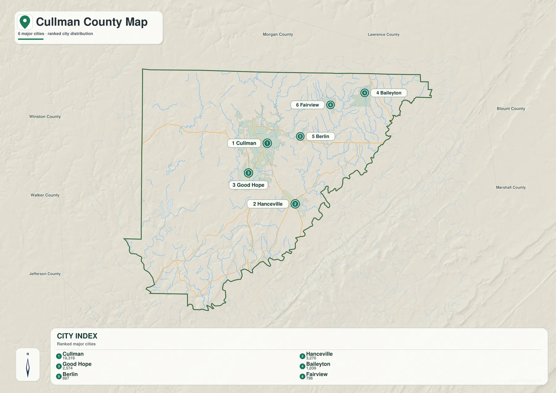
The general map and city map are best used together. The city version is cleaner when the goal is to compare settlement centers, but it does not include every place shown on the broader county map. West Point, Holly Pond, Garden City, Dodge City, Colony, and South Vinemont still matter when locating destinations or understanding the county as a whole. Readers looking for a route should therefore return to the general map after using the city map for orientation.
Cullman also has a distinctive historical background. The city traces its origin to a settlement established in the 1870s by Johann Gottfried Cullmann, a German immigrant. That heritage remains part of the identity of the county seat, but the present-day geography is shaped just as strongly by highways, farms, small towns, and the reservoir landscape to the west. Seeing the towns in their actual positions helps separate the historic center from the broader modern county.
Lewis Smith Lake and the county’s branching waterways
Water changes the appearance of western Cullman County more than any road does. Lewis Smith Lake enters the county in a long series of coves and narrow arms, creating an irregular shoreline along the Winston and Walker County side. Ryan Creek is labeled near the lake, while Crooked Creek and Rock Creek appear farther north and northwest. Roads in this part of the county often have to follow ridges or reach a bridge before crossing water, so straight-line distance can be misleading when planning travel near the reservoir.
The water map also makes clear that the rest of the county is far from dry. Duck River runs through the eastern part, Broglen River is labeled southeast of the center, and Black Warrior River appears near the southern boundary. Smaller named water bodies include Harbisons Pond, White Pond, Lake Catoma, Sportsmans Lake, Twin Fork Lake, and Hart Lake. These features give a much better sense of the local drainage network than the general road map, where many small streams appear only as thin blue lines.
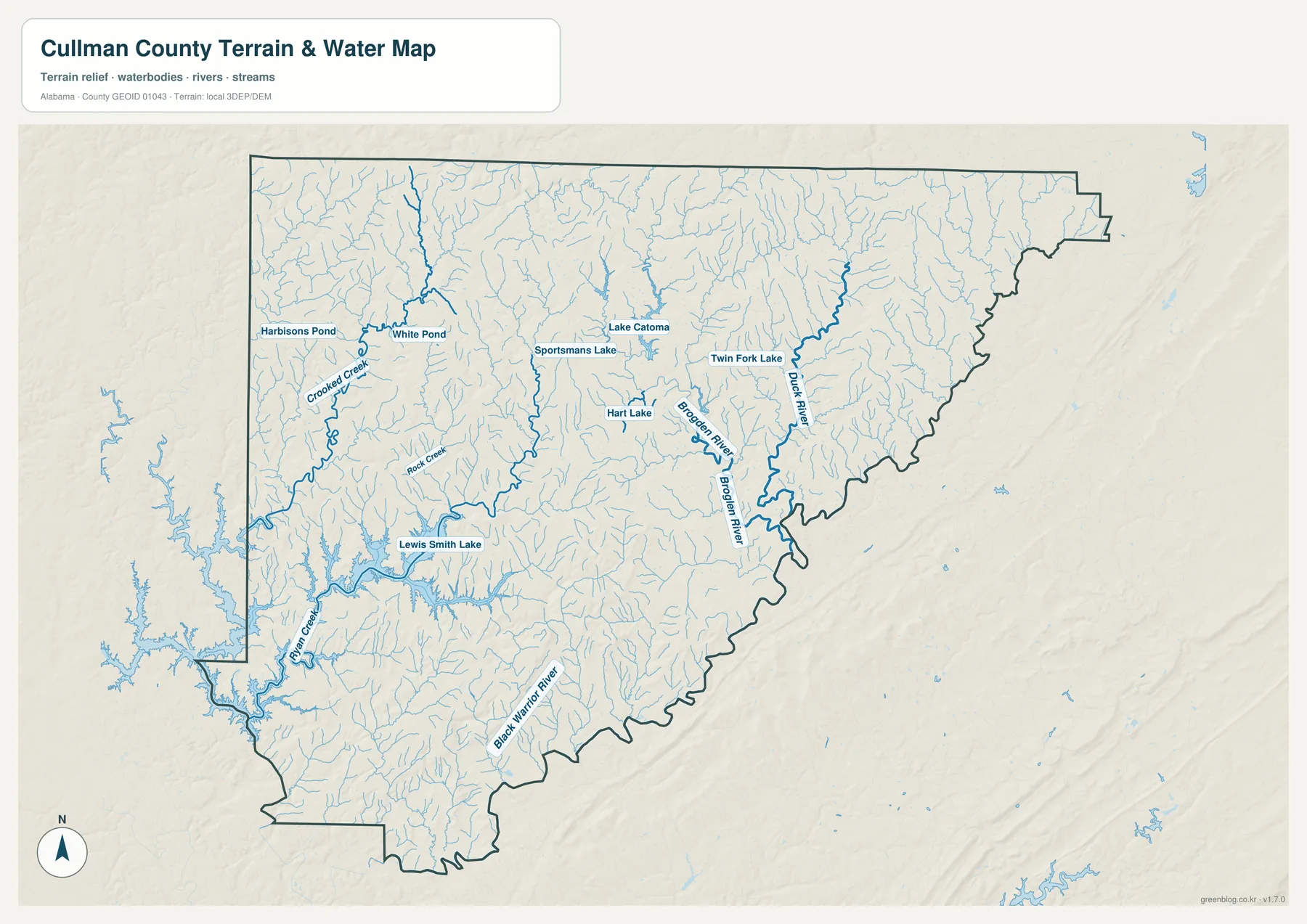
Lewis Smith Lake is not contained entirely within Cullman County. Official Alabama information describes the reservoir as extending through Cullman, Winston, and Walker counties. That matters when reading the western boundary because a cove or opposite shoreline may lie in another county even when it looks nearby on the map. Anyone using the lake for property, boating, or regulatory questions should consult the appropriate detailed official source; this map is intended for geographic orientation rather than legal or navigational decisions.
Comparing the water map with the town map reveals a useful county-specific contrast. Cullman, Good Hope, and Hanceville are associated most strongly with the central transportation corridor, while the west is broken into ridges, valleys, creeks, and reservoir arms. The east contains fewer large water bodies but many small streams. This difference explains why the county can feel compact around I-65 yet much more indirect to travel across near Smith Lake.
Elevation from the northern uplands to lower southern valleys
The elevation map shows an actual range of roughly 79 to 343 meters, with a mean near 229 meters. Higher ground appears mostly in brown and tan, while lower valleys are shown in greener tones. Northern and northeastern Cullman County contain broad areas of higher terrain cut by narrow stream valleys. Around the center, the surface becomes more mixed, and lower ground becomes increasingly visible toward the south and southwest.
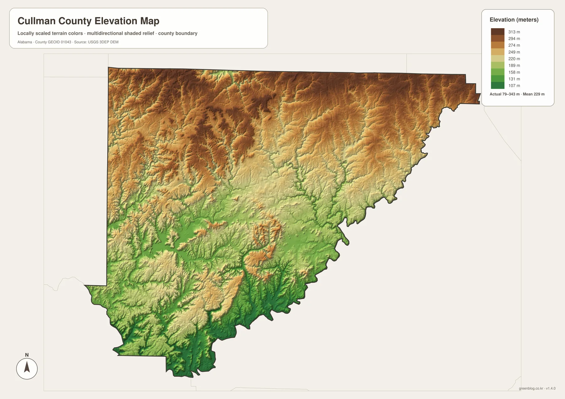
The western reservoir area is especially interesting on the elevation map. Smith Lake follows low valleys that cut deeply between higher ridges, which helps explain its long, branching shoreline. Similar narrow green corridors appear where creeks have cut through the uplands elsewhere in the county. When the water and elevation maps are viewed side by side, many of the major stream paths line up with these lower valleys rather than crossing the highest ridges.
This map is meant for comparing broad terrain, not for surveying an individual property. It can answer practical questions such as which part of the county is generally higher, where valley systems are concentrated, and why some waterways or roads follow curving routes. Precise construction elevations, parcel boundaries, and engineering measurements require dedicated official data. For general county geography, however, the elevation layer adds information that a flat boundary map cannot show.
Choosing the right Cullman County map for the task
The general county map is the best starting point when you need roads, county boundaries, towns, and nearby counties in one view. Use the city map when the main question is where the larger population centers sit relative to Cullman. The water map is better for Smith Lake, creeks, rivers, and smaller lakes, while the elevation map is the clearest choice for comparing uplands, valleys, and terrain around the reservoir. Moving between the maps keeps each one readable instead of forcing every detail into a single crowded image.
- Use the general map for Cullman, Good Hope, Hanceville, I-65, U.S. 31, U.S. 278, and county boundaries.
- Use the city map to compare Cullman, Hanceville, Good Hope, Baileyton, Berlin, and Fairview.
- Use the water map for Lewis Smith Lake, Ryan Creek, Duck River, Broglen River, and smaller lakes.
- Use the elevation map to compare the roughly 79–343 meter range and the higher north with lower southern valleys.
For school projects or regional introductions, a useful sequence is to show the general map first and then add either the water or elevation map to explain the landscape. For travel planning, begin with I-65, U.S. 31, and U.S. 278, then check the water map if the destination is near Smith Lake because coves and crossings can affect the route. These maps are county-scale references, so street-level navigation and official legal boundaries should still be checked with current local or state sources.
The four files also work well when the same county needs to be shown in different ways. A presentation may only need the clean city distribution, while a geography lesson can pair waterways and elevation. A visitor planning a route may care most about the road map, and someone comparing natural features may begin with Smith Lake and the terrain. The separate JPGs make it possible to use only the layer that fits the question instead of relying on one all-purpose image.
Frequently Asked Questions
Is Lewis Smith Lake entirely inside Cullman County?
No. Lewis Smith Lake extends across Cullman, Winston, and Walker counties. Along the western side of Cullman County, the opposite shore of a cove may therefore be in another county, so the water map should be read together with the county boundary when location matters.
What is the difference between the city map and the general county map?
The general map includes the road network, county boundary, many place names, and nearby counties. The city map removes much of that detail and focuses on six major places—Cullman, Hanceville, Good Hope, Baileyton, Berlin, and Fairview—so their relative positions are easier to compare.
What can the Cullman County elevation map be used for?
It is useful for comparing higher uplands with lower valleys across the county. The legend shows an actual range of about 79 to 343 meters and a mean near 229 meters, but the map is not intended to replace parcel surveys, engineering measurements, or site-specific elevation data.
Map File Information
Cullman County high-resolution map files
- Included Files: county, city, water, and elevation maps
Related Maps
Sources and references
The following official and local resources are useful for checking county and municipality information, roads, waterways, terrain, and background on Cullman. The map descriptions on this page are based primarily on the four map previews and asset information included in the rewrite package.
- Cullman County Commission official county and municipality information
- ALDOT Highway Functional Classification Maps
- Outdoor Alabama: Lewis Smith Lake
- USGS National Hydrography
- USGS 3D Elevation Program
- City of Cullman official history FAQ
Green Map creates custom-edited map images using open geographic data sources such as geoBoundaries, Natural Earth, OpenStreetMap, and government open data. These maps are edited visual materials, not raw data files, and are provided for education, documents, presentations, and graphic reference.