A South America Map has to solve an unusual visual problem: the continent combines Brazil’s enormous eastward reach, Chile’s extremely narrow Pacific strip, a compact group of northern countries, and the tapering lands of Argentina and Chile in the far south. On a small world map, those differences often leave the Guianas, Uruguay, and several border relationships difficult to read. A dedicated continental layout gives each country enough space to be recognized while preserving the long north-to-south shape.
This collection contains three versions: a color-coded labeled map, a black-and-white labeled map, and a blank outline map. The download package is supplied in JPG, PNG, and ZIP formats and prepared for high-resolution A3 use. Teachers, students, bloggers, travelers, and designers can select a finished reference or a base for their own markings.
The maps focus on country locations rather than cities, roads, elevation, or physical relief. Both labeled editions identify the 12 independent countries and French Guiana, while the outline edition removes the names and fills. The set supports reference, recall exercises, routes, and country-level data shading without pretending to be a road atlas or boundary authority.
Table of Contents
Reading the South America Map from North to South
The continent is bordered by the Pacific Ocean on the west and the Atlantic Ocean on the east, both of which are named on the color and monochrome maps. Across the northern edge, Colombia faces both the Pacific and Caribbean sides, Venezuela stretches eastward, and Guyana, Suriname, and French Guiana form a compact Atlantic sequence. The three Guianas need careful label placement because their areas are small beside Venezuela and Brazil.
Brazil provides the main visual anchor on the South America Map. It occupies most of the central and eastern portion and shares land boundaries with every independent mainland South American country except Chile and Ecuador. This relationship helps learners orient the surrounding countries: Colombia, Venezuela, Guyana, Suriname, Peru, Bolivia, Paraguay, Argentina, and Uruguay all meet Brazil, while French Guiana also borders it as a French overseas department and region.
The western edge creates a different pattern. Colombia, Ecuador, Peru, Bolivia, and Chile follow the broad north-to-south course associated with the Andes, although Bolivia is landlocked and does not reach the Pacific. Chile continues as a long coastal band beside Argentina, whose territory becomes the dominant shape in the southern cone. Paraguay and Bolivia are the continent’s two landlocked independent countries, a fact that can be checked directly by tracing their enclosed boundaries.
Countries, Territories, and Labeling Limits
There are 12 independent countries shown: Argentina, Bolivia, Brazil, Chile, Colombia, Ecuador, Guyana, Paraguay, Peru, Suriname, Uruguay, and Venezuela. French Guiana is also labeled because it occupies part of the mainland between Suriname and Brazil, but it is not a thirteenth independent country. It is an overseas department and region of France, so classroom instructions should distinguish geographic inclusion from national sovereignty.
Country size affects how names fit. Brazil, Argentina, Peru, Bolivia, Colombia, and Venezuela have enough interior space for centered labels. Chile is too narrow for that treatment, while Guyana, Suriname, French Guiana, and Uruguay benefit from outside labels connected by leader lines. Paraguay’s name is split across two lines in the supplied labeled images. These choices keep the smaller shapes visible instead of allowing text to cover their borders.
The map is intended as a country-level learning resource, not as a detailed treatment of disputed territories or offshore claims. Small island shapes may appear, but they are not consistently named or explained. Anyone preparing a lesson about sovereignty, maritime limits, or territorial disputes should pair this collection with a current authoritative reference and make the scope of any added labels clear.
Color-Coded Continental Reference
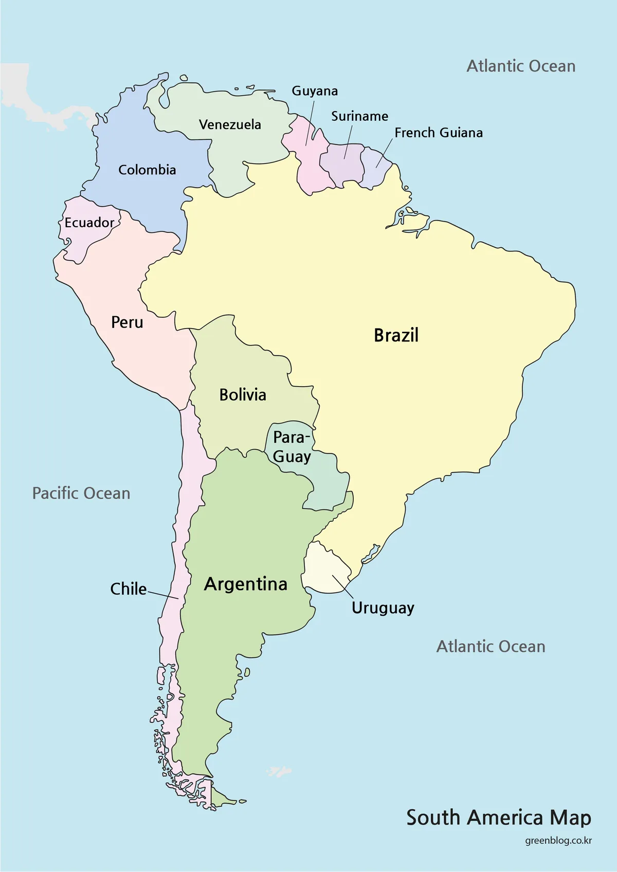
Pastel fills give each mapped country or territory a separate visual identity without using heavy saturation. The color South America Map makes the northern Atlantic sequence especially easy to follow: Venezuela, Guyana, Suriname, French Guiana, and Brazil can be separated at a glance even though several are much smaller than Brazil. Uruguay also remains distinct between Argentina and the Brazilian coast.
Color strengthens pattern recognition elsewhere. Chile’s narrow form can be followed continuously down the Pacific margin, while Argentina’s wider shape stands apart beside it. Bolivia and Paraguay are readily identified as inland areas because their colored shapes do not touch the blue ocean background. This edition is the clearest choice for audience-facing slides, country comparison graphics, and introductory geography pages where immediate recognition matters.
Labeled Black-and-White Map
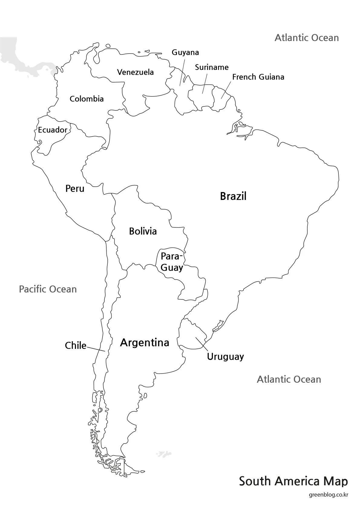
The monochrome South America Map retains all country and ocean names while removing the colored country fills. Thin black borders carry the structure, white interiors keep the page calm, and gray ocean labels sit outside the continent. This balance allows the map to accompany text, tables, or charts without introducing another palette into the document.
Leader lines remain important in the north and around Uruguay. If the image is reduced sharply, those connectors and the small labels will become difficult to follow before the larger names do. For worksheets or reports, preserve the portrait ratio and check Guyana, Suriname, French Guiana, Chile, and Uruguay in print preview. The black-and-white edition is preferable when readers need a labeled reference but are expected to underline, circle, or annotate countries by hand.
Blank Country Outline
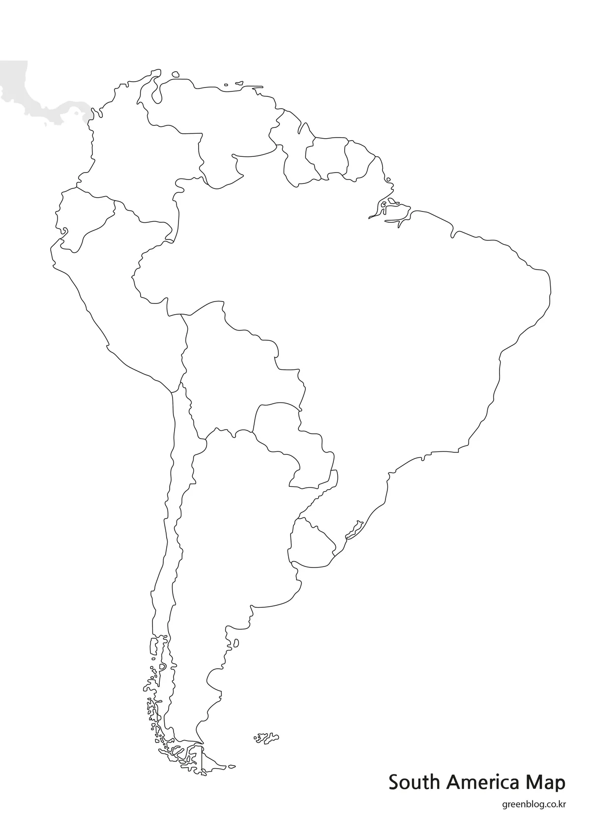
Names, color fills, and ocean labels are removed from the outline edition, leaving the continental coast and internal country divisions. This blank South America Map still includes recognizable details such as Chile’s narrow western band, the southern archipelago, the compact Guianas, and the large Brazilian outline. Because the supplied resource is an image rather than a confirmed vector source, it should be described as an annotation base rather than an editable SVG or design file.
The blank layout supports several specific exercises. Students can label the 12 independent countries and then identify French Guiana with a different symbol. They can color the two landlocked countries, trace a hypothetical route from Colombia to Patagonia, group the Andean countries, or shade country-level statistics from a cited dataset. Designers can add numbered markers when text would otherwise crowd the northern coast.
Choosing the Right File for the Task
Choose by deciding whether the reader needs recognition, reference, or participation. The color file provides the fastest separation of neighboring countries and performs best when a map will be projected or viewed briefly. The black-and-white file keeps every supplied label available for study sheets and written reports. The outline file asks the viewer to supply information, making it the strongest option for tests, coloring activities, route diagrams, and custom thematic graphics.
The portrait format is essential to the South America Map because the continent is much taller than it is wide. Stretching the image into a landscape box would widen Chile and shorten the southern cone, weakening the geographic comparison. Crop only the surrounding whitespace when necessary, keep the original proportions, and verify that the northern labels remain legible after placement.
All three attached previews measure 1200 × 1696 pixels, while the supplied download information identifies an A3 high-resolution layout and JPG, PNG, and ZIP delivery. Use the ZIP archive to keep the versions together. When exporting a document, avoid repeated image compression and inspect fine coastlines around southern Chile as well as the small northern boundaries before printing.
Practical Geography and Design Activities
A strong lesson can move through the three maps rather than relying on only one. Begin with the color edition to establish the continental pattern, switch to monochrome for name review, and finish with the outline for recall. Learners can then explain why Brazil touches so many neighbors, why Ecuador and Chile do not border it, and why Bolivia and Paraguay have no coastline.
For a travel or transport graphic, the South America Map can provide a country-level route frame, but it does not contain roads, airports, or distances. Add those elements from current sources and include a legend that distinguishes original boundaries from new route information. Long routes can be divided into regional stages so markers do not obscure Ecuador, Uruguay, or the Guianas.
The outline version can also support thematic comparisons, such as language groups, ocean access, or verified country statistics. Use a limited color scale and state the year of any data placed on the map. A continental map communicates relative location effectively, but country area on the page should never be treated as a substitute for population, economic, climate, or elevation data.
Frequently Asked Questions
What places are identified on the South America Map?
The color and black-and-white editions label 12 independent countries: Argentina, Bolivia, Brazil, Chile, Colombia, Ecuador, Guyana, Paraguay, Peru, Suriname, Uruguay, and Venezuela. They also label French Guiana and both the Pacific and Atlantic oceans. The outline edition preserves the boundaries but removes these names.
Why is French Guiana included if it is not an independent country?
French Guiana occupies mainland South America between Suriname and Brazil, so omitting it would leave a misleading gap along the northern Atlantic coast. It is an overseas department and region of France, not a sovereign South American state. A classroom key can use a different color or symbol to make that distinction explicit.
Which version should I use for a country-labeling exercise?
Use the blank outline map for the activity and keep the labeled black-and-white edition as the answer reference. Ask learners to identify the 12 countries first, then mark French Guiana separately. Numbered callouts can help with Guyana, Suriname, and French Guiana, where full handwritten labels may not fit comfortably.
Are the files suitable for A3 printing?
Yes. The supplied resource information identifies an A3 high-resolution layout, with JPG and PNG images grouped in a ZIP download. Keep the portrait proportions when placing the map on an A3 page. Preview the smaller northern labels and the detailed southern coastline before producing multiple copies.
Does the map show the Andes, cities, or travel roads?
No. The collection shows country and territory boundaries, with names added only on the two labeled versions. It does not map mountain relief, cities, roads, airports, or distances. Those features can be added to the blank edition from suitable sources, but they should be clearly identified as user-added information.
Map File Information
This download includes printable South America map versions for educational use, presentation design, document printing, and editable graphic projects.
- Included Versions: Color map, black and white map, outline map
- Printable Size: A3 layout
- File Type: JPG, PNG, and ZIP
- Intended Use: Classroom handouts, presentations, blog graphics, infographic editing, and printable reference materials
Related Maps
- Printable Guyana Map for Classrooms, Presentations, and Editing
- Download Uruguay Map Files for Printing, Editing, and Infographics
- Ecuador Map Download for Printing, Classroom Use, and Graphic Editing
- Printable Paraguay Map Collection for Education and Design Projects
- Central America Map Download – Printable Country Map Collection
Additional Resources
- Encyclopaedia Britannica — South America: Read an established overview of the continent’s physical setting, countries, regions, and geographic features.
Green Map creates custom-edited map images using open geographic data sources such as geoBoundaries, Natural Earth, OpenStreetMap, and government open data.
These maps are edited visual materials, not raw data files, and are provided for education, documents, presentations, and graphic reference.