A Sri Lanka map is especially useful when you need to explain the island’s location, regional structure, or travel routes in a clear visual format. Sri Lanka sits in the Indian Ocean, southeast of India, and its compact island shape makes it easy to recognize on a regional map. However, when the goal is to compare administrative areas, mark travel movement, or prepare classroom materials, a simple location image is often not enough.
This printable Sri Lanka map collection includes color, basic, black and white, and outline versions prepared for different types of use. The files are arranged in a high-resolution A3 layout and provided as JPG image files, making them suitable for blog graphics, educational worksheets, presentation slides, travel planning materials, and simple graphic editing projects. The map was created with a focus on readability rather than complex terrain detail, so the regional boundaries and labels remain easy to follow.
Because Sri Lanka is an island country, the coastline is an important part of the visual layout. During the map preparation process, the overall island shape was kept clean while the internal regional divisions were adjusted for easier viewing. The color version helps separate regions quickly, while the black and white and outline versions are better suited for printing, note-taking, and custom editing.
The collection is designed for users who need more than one style of map. Teachers can use the black and white version for handouts, bloggers can use the color version in country introduction posts, and designers can use the outline map as a base for infographic work. Whether you are preparing a classroom lesson, a travel route graphic, or a South Asia comparison material, these Sri Lanka map files give you several practical starting points.
Table of Contents
Sri Lanka Map Overview
Sri Lanka is a South Asian island country located below the Indian subcontinent. Its capital is Sri Jayawardenepura Kotte, while Colombo functions as the main administrative and commercial center. The country has a land area of about 65,610 square kilometers and a population of about 21 million people.
For map users, Sri Lanka’s island-based layout is the most important feature. The shape is compact, but the internal administrative divisions still need a clear layout when used in printed or educational materials. A labeled Sri Lanka map can help readers understand where Colombo is located, how the island is divided, and how different regions relate to one another.
Included Map Files
This map collection was prepared for practical use across both digital and printed materials.
- Printable Size: A3 layout
- File Type: JPG image files
- Color Mode: CMYK
- Included Versions: Color map, basic map, black and white map, outline map
- Main Uses: Classroom materials, presentation slides, blog graphics, travel planning, infographic editing, and printable reference sheets
Each version keeps the same overall map proportion, so users can switch between styles depending on the purpose of the project.
Regional Color Map
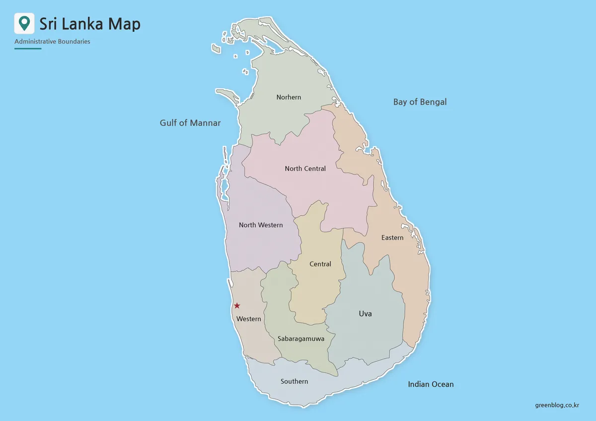
The color version is designed for quick visual reading. Since Sri Lanka has a compact island shape, color separation helps the viewer distinguish internal regions without losing the overall outline of the country. This is useful when preparing slides about South Asia, comparing regional divisions, or creating a country profile graphic.
Colombo is marked with a red star icon so that the main administrative and commercial center can be identified quickly. The regional labels are shown in both Korean and English in the original map style, which makes the image useful for bilingual reference materials or Korean-language educational content prepared for English-related projects.
The color tones were kept moderate so the labels would not disappear into the background. This makes the map easier to use in presentation slides, blog images, and printable reference pages where readability matters more than decorative styling.
Black and White Printable Version
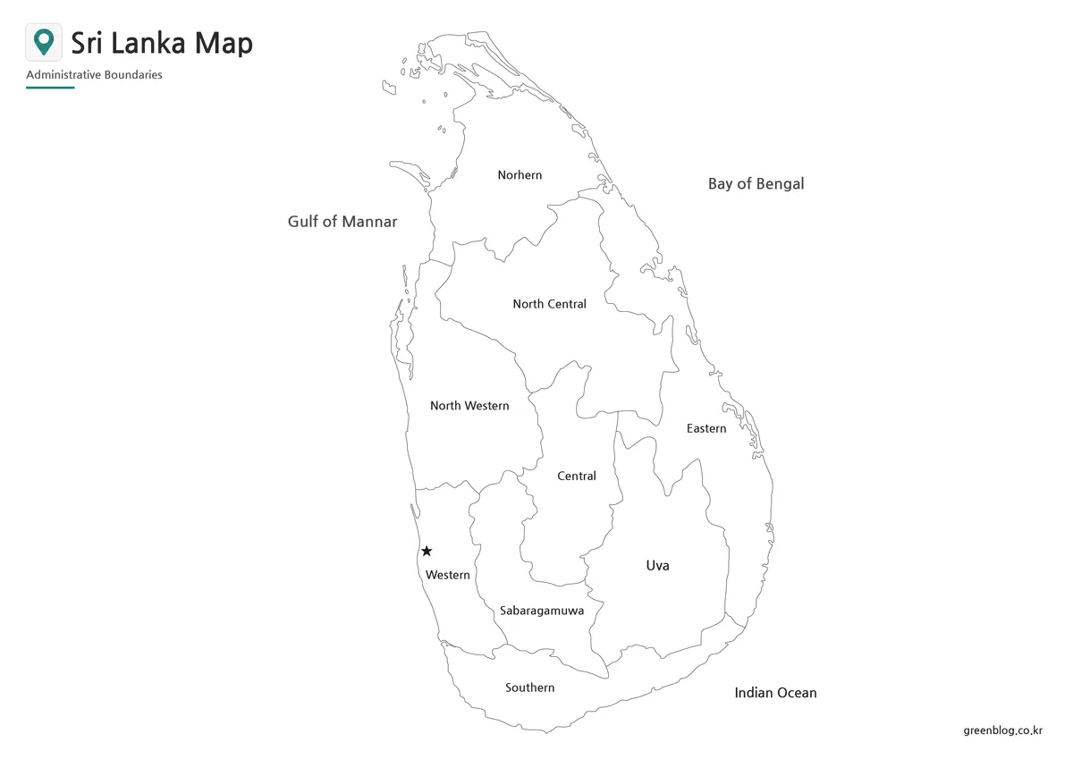
The black and white Sri Lanka map was prepared for users who mainly need a printable version. Without background color, the map is easier to insert into worksheets, study notes, school assignments, and handouts. The clean line structure also helps when printing in grayscale.
This version is especially useful for classroom activities. Students can mark Colombo, draw travel routes, label nearby ocean areas, or compare Sri Lanka with India and other South Asian countries. Because the map is not visually crowded, it leaves enough space for notes and manual annotations after printing.
Blank Outline Map for Editing
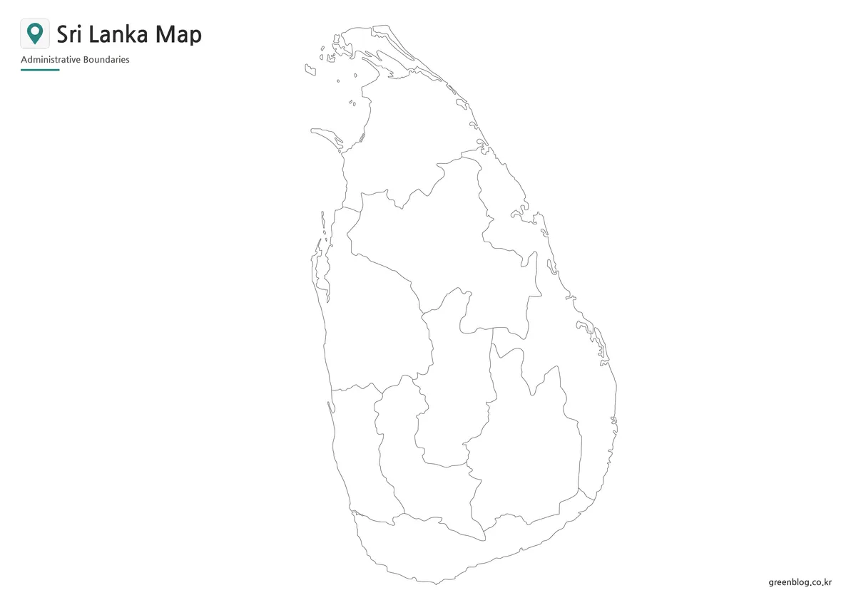
The Sri Lanka outline map keeps only the boundary structure and removes colors and text. This makes it a practical base map for editing work. Teachers can use it for coloring activities, while designers can add custom labels, statistics, travel routes, tourism points, or infographic markers.
A blank outline is also useful when the user does not want a finished labeled map. For example, it can be used to create a population distribution graphic, a regional comparison chart, a travel itinerary image, or a simple country location worksheet. The outline format gives users more control over what information appears on the final image.
Sri Lanka Flag Image
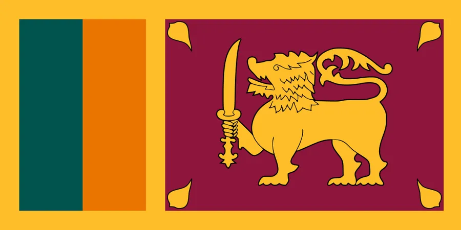
A high-resolution Sri Lanka flag image is also included for users who want to create a more complete country reference layout. When placed near the map, the flag helps identify the country quickly and gives the material a more finished appearance.
The flag image can be used in blog posts, school projects, travel slides, country comparison pages, or printable information sheets. Combining a flag and a map is especially helpful when creating educational resources for students who are learning about countries in South Asia.
Practical Uses for This Map Collection
This Sri Lanka map collection can be used in many types of visual materials. For travel content, the map can help show island-wide routes or explain where Colombo and other regions are located. For classroom use, the black and white and outline versions are suitable for worksheets, quizzes, and geography activities.
Bloggers and presentation creators may prefer the color version because it gives a clear regional structure without requiring extra editing. Designers can use the outline version as a base for custom graphics, such as tourism maps, regional data visuals, or South Asia comparison infographics.
The A3 layout also makes the map practical for larger print materials. Labels and boundaries were reviewed with printing in mind, so the map remains easier to read when enlarged for classroom boards, handouts, or presentation visuals.
Frequently Asked Questions
What is included in this Sri Lanka map collection?
The collection includes color, basic, black and white, and outline versions of the Sri Lanka map. A Sri Lanka flag image is also included for country reference materials.
Can I use the Sri Lanka map for printing?
Yes. The files are prepared in an A3 layout, making them suitable for classroom handouts, reports, worksheets, and printed reference sheets.
Which version is best for classroom use?
The black and white map is best for printed handouts, while the outline map works well for coloring activities, labeling practice, and geography worksheets.
Is the outline map useful for editing?
Yes. The blank outline version can be used as a base for adding travel routes, city markers, regional data, labels, or infographic elements.
Download Sri Lanka Map
This download includes printable Sri Lanka map versions for educational use, presentation design, document printing, and editable graphic projects.
- Included Versions: Color map, black and white map, outline map
- Printable Size: A3 layout
- File Type: JPG image files
- Intended Use: Classroom handouts, presentations, blog graphics, infographic editing, and printable reference materials
Additional Resources
- Survey Department of Sri Lanka – Official Mapping and GIS Services : Provides official mapping, GIS, and land information resources that can be useful when checking Sri Lanka’s geographic and administrative layout.
Related Maps
- Myanmar Map – Printable Color, Black and White & Outline Map
- Malaysia Map Resource with Color, Basic, Outline, and Flag Images
- Kazakhstan Map Download | Printable Color, Black and White & Outline Maps
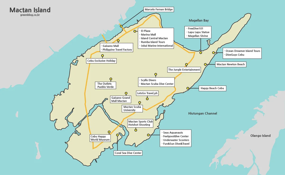
- Mactan Island Map Download – Printable Travel Map for Cebu Trips