Valley County lies in central Nebraska where Ord anchors a small group of communities spread across the North Loup River valley and the eastern edge of the Sandhills. This Valley County Nebraska Map page combines the Ord-centered road network, straight-line city connections to Elyria, North Loup, and Arcadia, the North and Middle Loup river systems, and an elevation view that contrasts higher western hills with lower river valleys. The WebP previews are designed for quick viewing, while the same four maps can be downloaded below as high-resolution JPG files in one ZIP archive. High-resolution map files are available for download in the section below.
Ord is the easiest place to use as an anchor. It is the county seat, sits near the North Loup River, and is served by Nebraska Highways 11 and 70. Elyria lies to the northwest, North Loup is southeast of Ord, and Arcadia occupies the southwestern part of the county. That arrangement gives Valley County a clear hub-and-valley pattern without the dense urban network found in larger counties.
Table of Contents
Ord at the center of the North Loup Valley road network
The general county map makes Ord the dominant reference point. Nebraska 11 connects the Ord area with the north toward Elyria and continues through the regional road system, while Nebraska 70 provides an important route toward Arcadia and the southwest. The North Loup River bends close to Ord, so roads, settlement, and the major river valley all meet in the same part of the county.
Elyria sits northwest of Ord near the Fort Hartsuff area. Arcadia lies close to the southwestern boundary along the Nebraska 70 corridor, while North Loup occupies the southeastern side of the county. Comstock and Scotia appear outside the county as useful orientation labels, but the dark boundary line is the best guide for distinguishing Valley County communities from neighboring places.
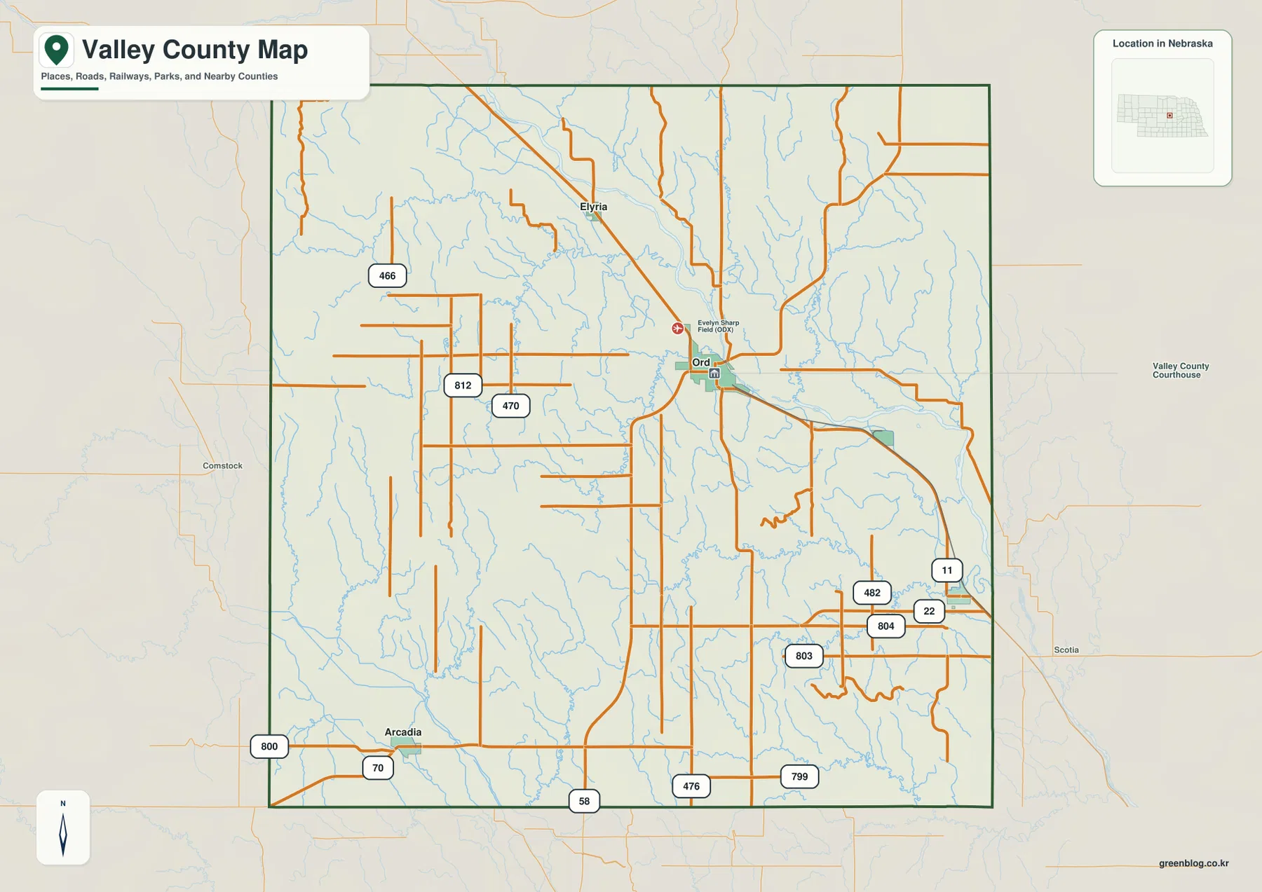
The official county website lists Ord, Arcadia, Elyria, and North Loup as the county’s cities and villages. County history records that Ord was chosen as the county seat in 1873 and laid out soon afterward. The modern map reflects that role: Ord contains the densest concentration of road and public-place labels and remains the strongest geographic reference for the rest of the county.
This image is a regional reference rather than a live navigation product. Construction, closures, and seasonal road conditions may change after a static map is produced. Its strength is orientation: readers can quickly see how Ord relates to Arcadia, North Loup, and Elyria and how the road network follows the North Loup River valley.
Straight-line connections from Ord to Elyria, North Loup, and Arcadia
The city-connections graphic uses Ord as the hub and links it with Elyria, North Loup, and Arcadia. The CITY CONNECTIONS index places Ord first, Arcadia second, North Loup third, and Elyria fourth. By reducing the road detail, the map makes the direction and spacing of the four communities much easier to compare.
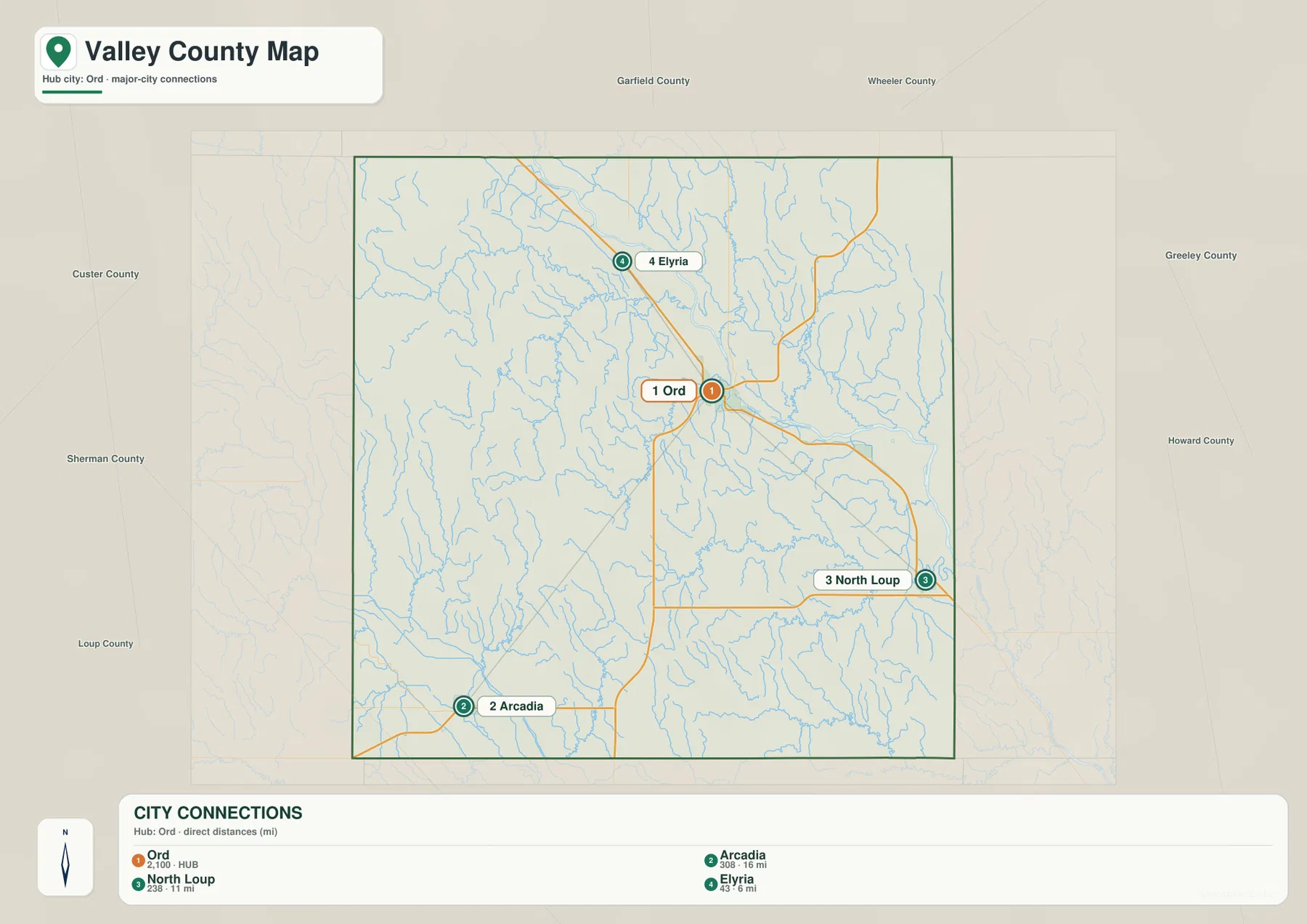
The graphic shows about 6 miles from Ord to Elyria, 11 miles to North Loup, and 16 miles to Arcadia. These values are straight-line distances between mapped points, not road mileage. Actual driving distances can be longer because highways and local roads follow river crossings, section lines, and terrain rather than a direct line.
Elyria is the closest ranked community and lies northwest of Ord, North Loup is southeast, and Arcadia is southwest. Because the three destinations occupy different directions, the map gives a useful sense of county scale around the Ord hub. Current population totals should be checked against the latest Census or local estimates when exact figures matter; the map is best used for geographic comparison.
North Loup River valleys with Dane, Turtle, Mira, and Davis creeks
The North Loup River is the dominant water feature in Valley County. It enters from the north, bends through the Ord area, and continues east and southeast toward the county boundary. Its broad lower valley is also one of the clearest features on the elevation map, making the river the strongest link between settlement, water, and relief.
North Branch Turtle Creek and South Branch Turtle Creek drain part of the western and northwestern interior, while Dane Creek runs through the center toward the North Loup system. Elm Creek enters from the northeast. In the southeast, North Branch Mira Creek and South Branch Mira Creek form a prominent pair, with Davis Creek farther south and Cottonwood Creek in the west.
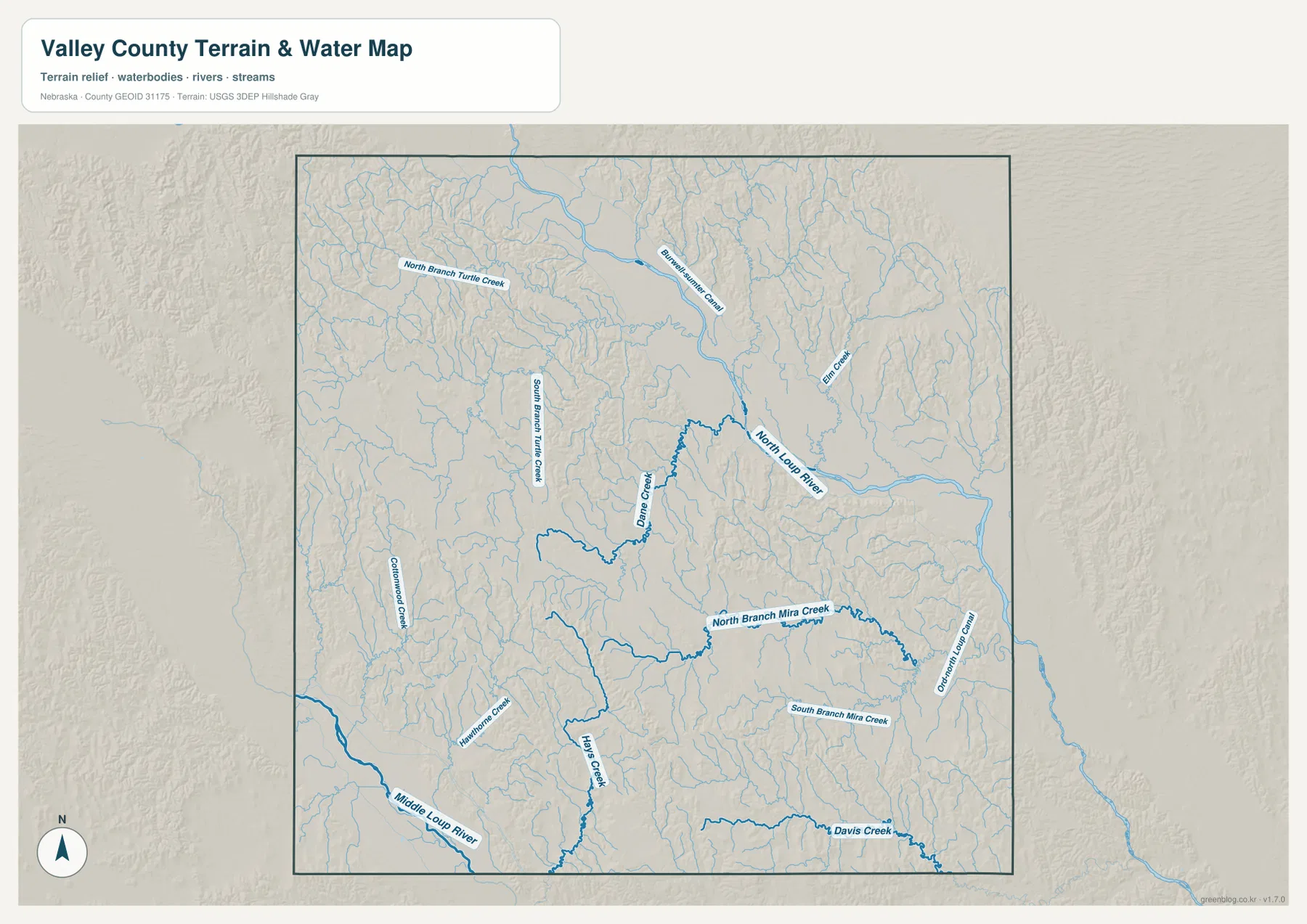
The Middle Loup River appears along the southwestern edge near the Arcadia area and creates a separate major valley from the North Loup. Hawthorne Creek and Hays Creek also drain that part of the county. Looking at both river systems together gives a better picture of Valley County than focusing on the North Loup alone, because the southern landscape belongs to a different major drainage corridor.
Blue line thickness and color should not be interpreted as measurements of discharge, depth, or flood risk. The map is designed to show the location of rivers, creeks, and channels at county scale. Floodplain determinations, stream access, property restrictions, and safety questions require current information from FEMA, USGS, or the appropriate local agencies.
Higher western hills above the North Loup River valley
The elevation map makes the county’s valley-and-upland contrast immediately visible. The displayed surface ranges from about 587 to 788 meters, with a mean near 670 meters. Brown and orange dominate much of the west and southwest, while green follows the North Loup River through the north, center, and east. The overall pattern is a descent from higher western terrain toward lower river country.
The North Loup valley forms a broad green corridor that bends through Ord and toward the eastern county line. Numerous tributaries cut into the higher ground on both sides, producing a dense pattern of narrow valleys and ridges. The Custer County side of the west is generally higher, while the Arcadia area in the southwest shows a second contrast between uplands and the Middle Loup River lowland.
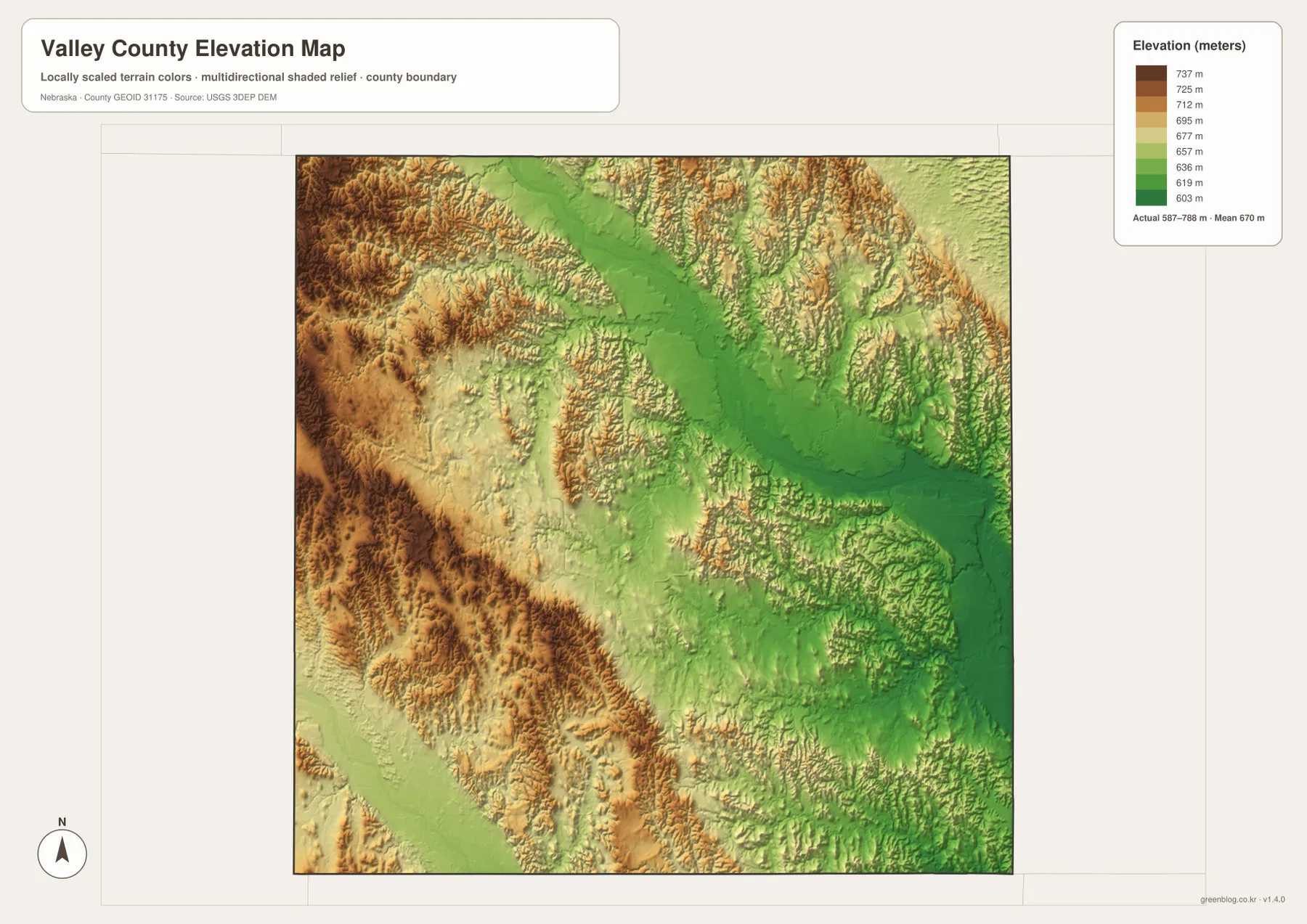
Elevation decreases toward the east, but the surface remains strongly dissected outside the main river bottom. Dane Creek, Mira Creek, Davis Creek, and other tributaries line up with lower green corridors on the shaded-relief image. This agreement between the water and elevation views makes it clear that Valley County is not a uniformly flat plain.
This elevation surface is intended for county-scale comparison, not parcel surveying or engineering. Exact site elevations, road grades, construction benchmarks, and design values require USGS source data, professional surveying, or another appropriate technical source. Here the image is most useful for comparing the Ord–North Loup corridor, western hills, and the Arcadia-side terrain.
Ord county-seat history and Fort Hartsuff near Elyria
Valley County’s official history says Ord was selected as the county seat in 1873 and laid out beginning in 1874. The town was named for General E. O. C. Ord, who commanded the Military Department of the Platte and traveled through the North Loup Valley while a site was being selected for Fort Hartsuff. Ord remains the county government and service center today.
Fort Hartsuff State Historical Park lies near Elyria and provides one of the county’s strongest links to nineteenth-century Great Plains history. Nebraska Game and Parks states that the fort served as an infantry outpost in the North Loup River Valley from 1874 to 1881. Many original buildings survived, and the site has been restored as a historical park interpreting military and local life of the period.
The city-connections map places Elyria about 6 straight-line miles from Ord, which helps locate the fort area within the wider county. The general county map also shows Elyria north of Ord along the valley road network. These maps are not detailed visitor maps for Fort Hartsuff, so current hours, admission, facilities, and park access should be checked with Nebraska Game and Parks before a visit.
Ord community information describes the city as sitting in the scenic North Loup Valley on the eastern edge of the Nebraska Sandhills. The elevation map supports that regional description: higher western hills transition toward a broad lower river corridor around Ord. Geography, transportation, and county history therefore meet in the same central valley.
A useful order for comparing communities, rivers, and relief
Begin with the general county map by locating Ord and then Arcadia, North Loup, and Elyria. The city-connections graphic provides a second view by showing straight-line spacing from Ord to the other three ranked communities. Because the displayed mileage is not driving distance, it works best as a quick county-scale reference rather than a route-planning tool.
Next, use the water map to trace the North Loup River and the Middle Loup River and to identify Dane Creek, Mira Creek, and Davis Creek. The elevation image then shows how those waterways occupy lower corridors between higher hills. The contrast is especially clear around Ord and in the western half of the county.
High-resolution JPG files are better suited to printing and close inspection when smaller creek names and road labels matter. These maps remain regional references rather than legal or safety documents. County boundaries can be checked against Census TIGER/Line data, waterways against USGS National Hydrography, and elevation against the USGS 3D Elevation Program.
Frequently Asked Questions
Are the Ord-to-Elyria, North Loup, and Arcadia mileages driving distances?
No. The city-connections map shows straight-line distances of about 6 miles from Ord to Elyria, 11 miles to North Loup, and 16 miles to Arcadia. Actual road mileage can be longer because roads follow terrain and available river crossings.
Where does the North Loup River cross Valley County?
The North Loup River enters from the north, bends through the Ord area, and continues toward the east and southeast. The Middle Loup River appears separately along the southwestern side near Arcadia, with numerous tributary creeks between the two valleys.
Can the elevation map be used for surveying or engineering?
No. It is intended to compare western hills, tributary valleys, and the North Loup River lowland at county scale. Exact site elevations, road grades, and engineering benchmarks require appropriate USGS source data or professional surveying.
Map File Information
Download the four high-resolution JPG maps shown on this page for Valley County in one ZIP archive.
- Included Files: Use only the versions confirmed in the article and supplied images
- File Type: Use the confirmed download contents
- Intended Use: Printing, education, presentations, and map-based projects
Related Maps
Sources and references
Ord county-seat history and community listings come from the official Valley County website. Fort Hartsuff and North Loup Valley background comes from Nebraska Game and Parks and Ord community resources, while the federal sources below provide authoritative references for boundaries, hydrography, and elevation.
- Valley County – Official Website
- Valley County – Ord History
- Nebraska Game and Parks – Fort Hartsuff
- Ord & Valley County Community
- U.S. Census Bureau – TIGER/Line Shapefiles
- USGS – National Hydrography
- USGS – 3D Elevation Program
Green Map creates custom-edited map images using open geographic data sources such as geoBoundaries, Natural Earth, OpenStreetMap, and government open data. These maps are edited visual materials, not raw data files, and are provided for education, documents, presentations, and graphic reference.