Cherry County covers a huge part of north-central Nebraska, with Valentine near the northeast and miles of Sandhills stretching west and south. The Niobrara River cuts across the northern interior, the Snake and North Loup rivers cross farther south, and Merritt Reservoir sits among a broad complex of Sandhills lakes. Higher ground dominates the west and southwest, while the Niobrara valley and eastern side are markedly lower. High-resolution map files are available for download in the section below.
This page explains the county road network, the distribution of Valentine and the smaller northern communities, the major rivers and Sandhills lakes, and an elevation range of about 673 to 1,270 meters. The original high-resolution JPG versions of the supplied maps can also be downloaded together in a ZIP for printing, classroom use, or personal reference.
Table of Contents
Valentine is the main reference point in Nebraska’s largest county
Valentine is the Cherry County seat and the clearest place to begin. The official county profile says Cherry County was founded in 1883, was named for Lt. Samuel A. Cherry, and has about 5,960 square miles of land, making it the largest county in Nebraska. Valentine sits toward the northeast rather than the geometric center, but roads and services make it the dominant settlement on the map.
The county reaches the South Dakota line on the north and extends a very long distance east to west across the Nebraska Sandhills. The southern boundary is comparatively straight, while the northern interior is cut by the Niobrara River and many short tributaries. The size alone creates noticeable differences between the Valentine area, the U.S. 20 towns to the west, and the sparsely settled southern Sandhills.
Cherry County’s official profile also notes that both Central and Mountain time zones occur within the county. That fact makes more sense when the map is viewed at full scale: Valentine and the eastern side are a long way from Merriman and the far western ranch country. Most named communities concentrate near the northern road corridor, leaving the southern half remarkably open.
U.S. 20 strings the northern towns together while three highways reach south
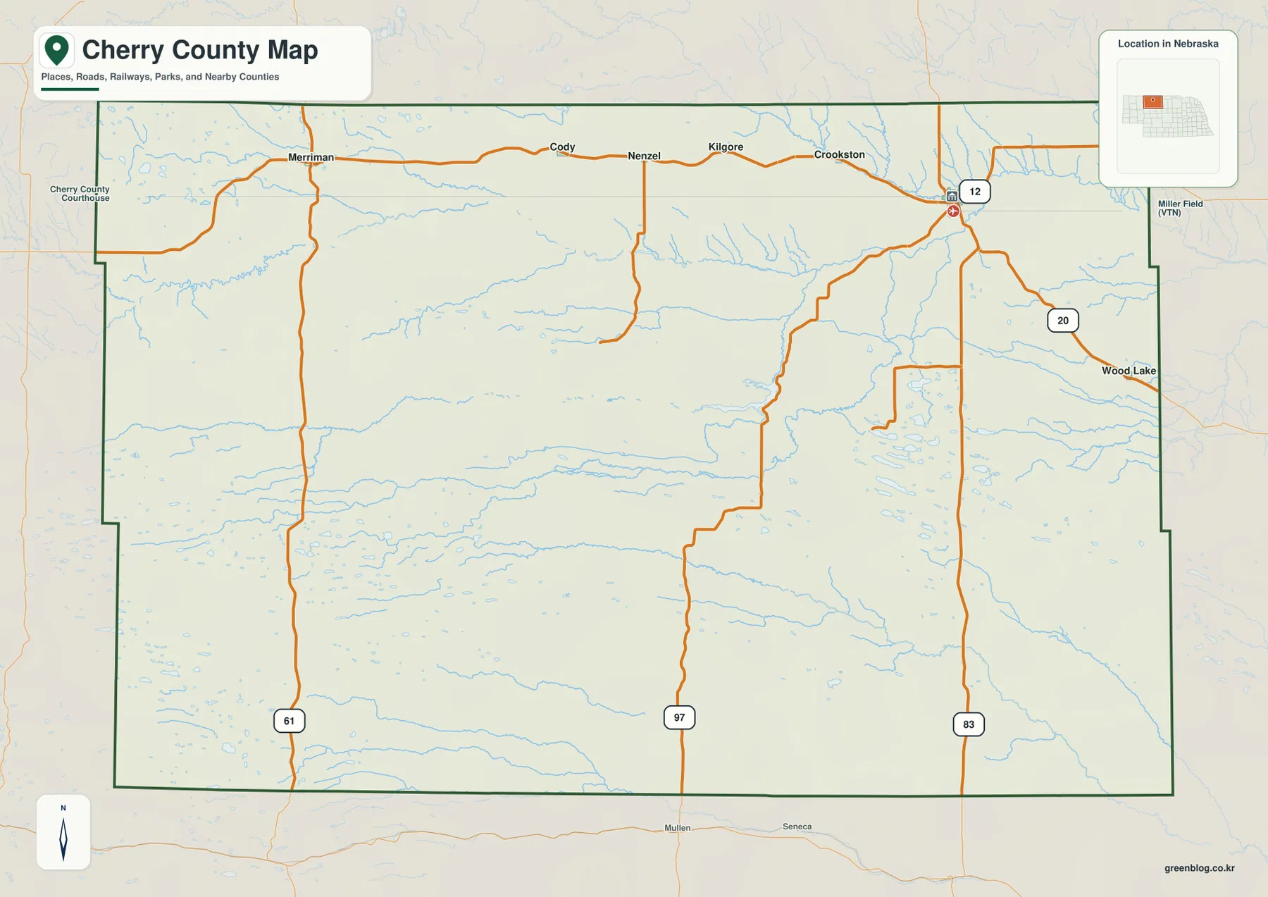
U.S. 20 is the strongest east-west line on the general map. Starting at Valentine and moving west, the route passes Crookston, Kilgore, Nenzel, Cody, and Merriman. This long chain of communities provides an easy way to organize the northern third of Cherry County before looking south into the much more sparsely settled Sandhills.
U.S. 83 drops south from Valentine, Route 97 provides another long north-south line through the central county, and Route 61 serves the western side. Route 12 appears near Valentine toward the northeast. Together these roads connect the northern town corridor with ranches, lakes, river crossings, and recreation areas scattered across the interior.
Road spacing increases sharply south of U.S. 20. Sandhills ridges, wet valleys, lakes, and long stretches of ranch country leave fewer major connections than in the north. The map is useful for overall orientation, but current construction, seasonal road conditions, closures, and driving time should be checked with Nebraska 511 or another live source.
The ranked city map emphasizes the northern U.S. 20 corridor
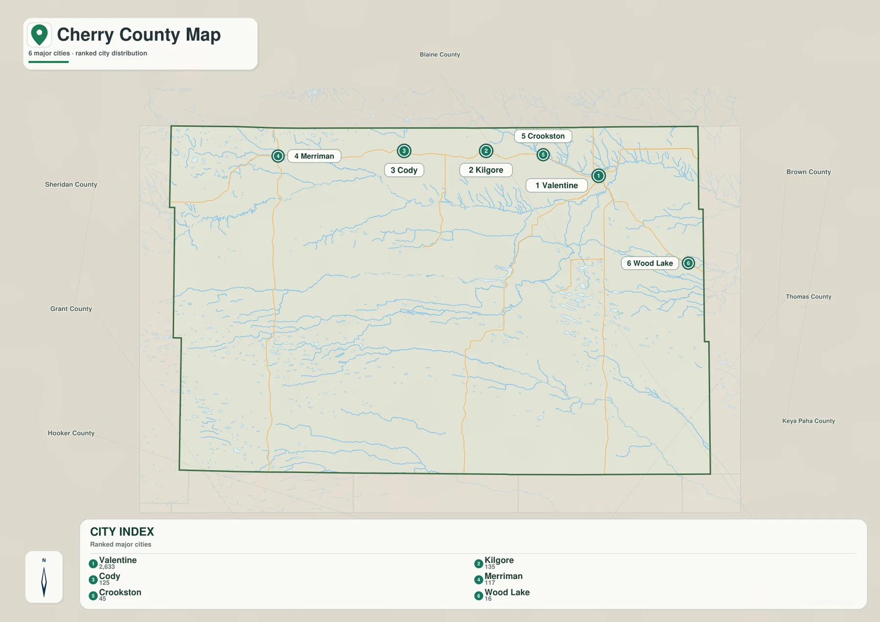
The city distribution map ranks Valentine first, followed by Cody, Kilgore, Merriman, Crookston, and Wood Lake. Valentine is northeast, while Crookston, Kilgore, Cody, and Merriman form a long westward sequence near U.S. 20. Wood Lake sits toward the eastern side and is separated from that line of western communities.
No connector lines or mileage labels appear on the supplied city map. The useful comparison is therefore positional rather than numerical. That matters in Cherry County because straight-line distance can be misleading across such a large rural area; actual travel depends on the limited highway network, river crossings, and the location of Sandhills roads.
The official county profile also lists Nenzel, Brownlee, Sparks, and Eli among Cherry County’s communities. The six-place city map is a ranked summary rather than a complete settlement inventory. It also makes one important geographic fact obvious: the county’s named towns are heavily concentrated in the north while the southern interior remains largely rural.
Niobrara River cuts the north while the Snake feeds Merritt Reservoir
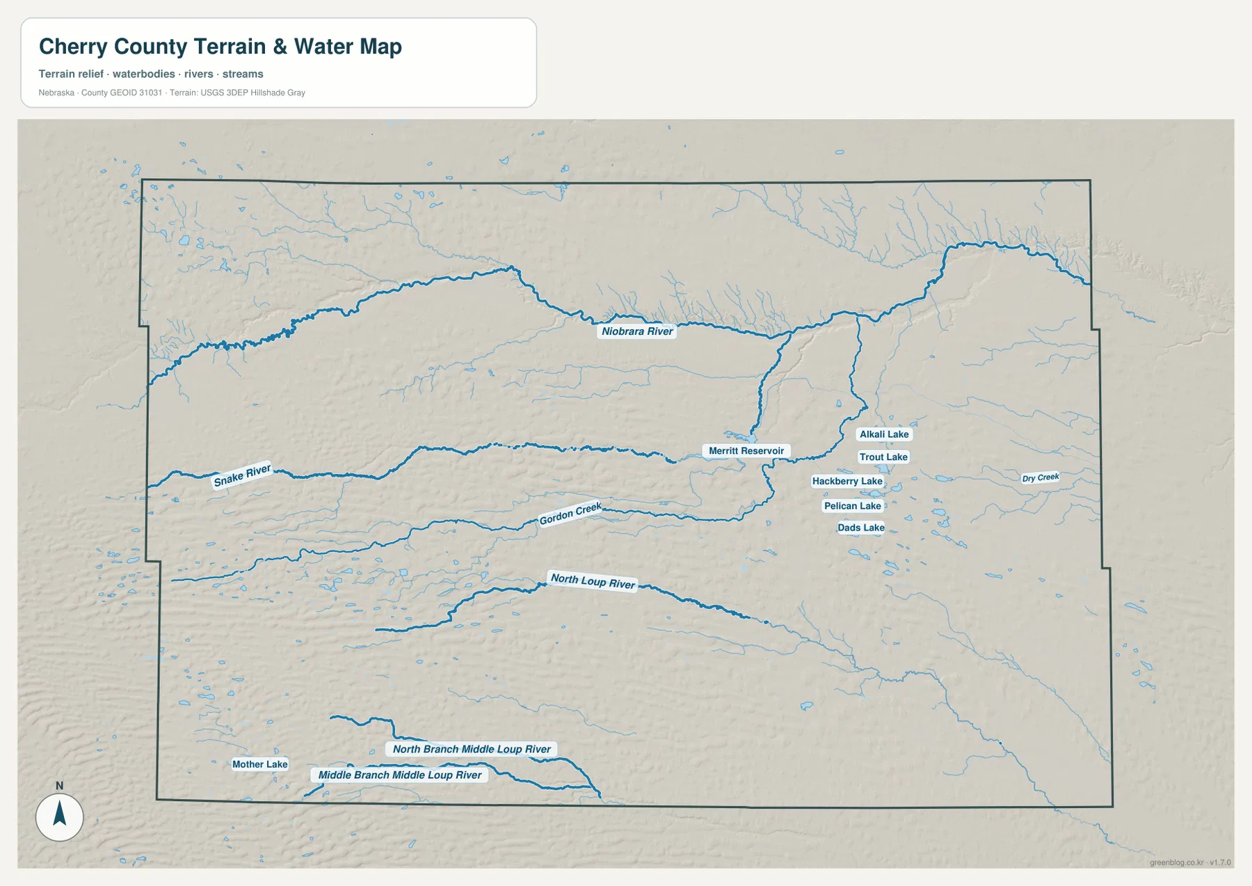
The Niobrara River is the dominant watercourse in the northern interior. It enters from the west, crosses the county in a long winding valley, and becomes especially deeply cut around and east of Valentine. The National Park Service protects a 76-mile scenic reach beginning near Valentine, where the river valley is one of the region’s defining natural features.
South of the Niobrara, the Snake River runs east toward Merritt Reservoir. The reservoir sits within a remarkable lake district that includes Alkali Lake, Trout Lake, Hackberry Lake, Pelican Lake, and Dads Lake. These water bodies occupy low spaces between Sandhills ridges and help explain why the county’s central-eastern interior looks very different from a simple dry-plains landscape.
Gordon Creek runs farther south, followed by the North Loup River through the south-central county. Near the southern edge, North Branch Middle Loup River and Middle Branch Middle Loup River form additional long drainage lines. Mother Lake and many smaller unnamed lakes appear in the southwest, giving the southern Sandhills a dense pattern of wet depressions as well as flowing streams.
This water map is for geographic reference. It does not define flood zones, legal water rights, parcel boundaries, reservoir levels, channel depth, navigability, or public access. Current water and access conditions should be checked with the responsible agencies.
Nearly 600 meters separate the low river country from the western Sandhills
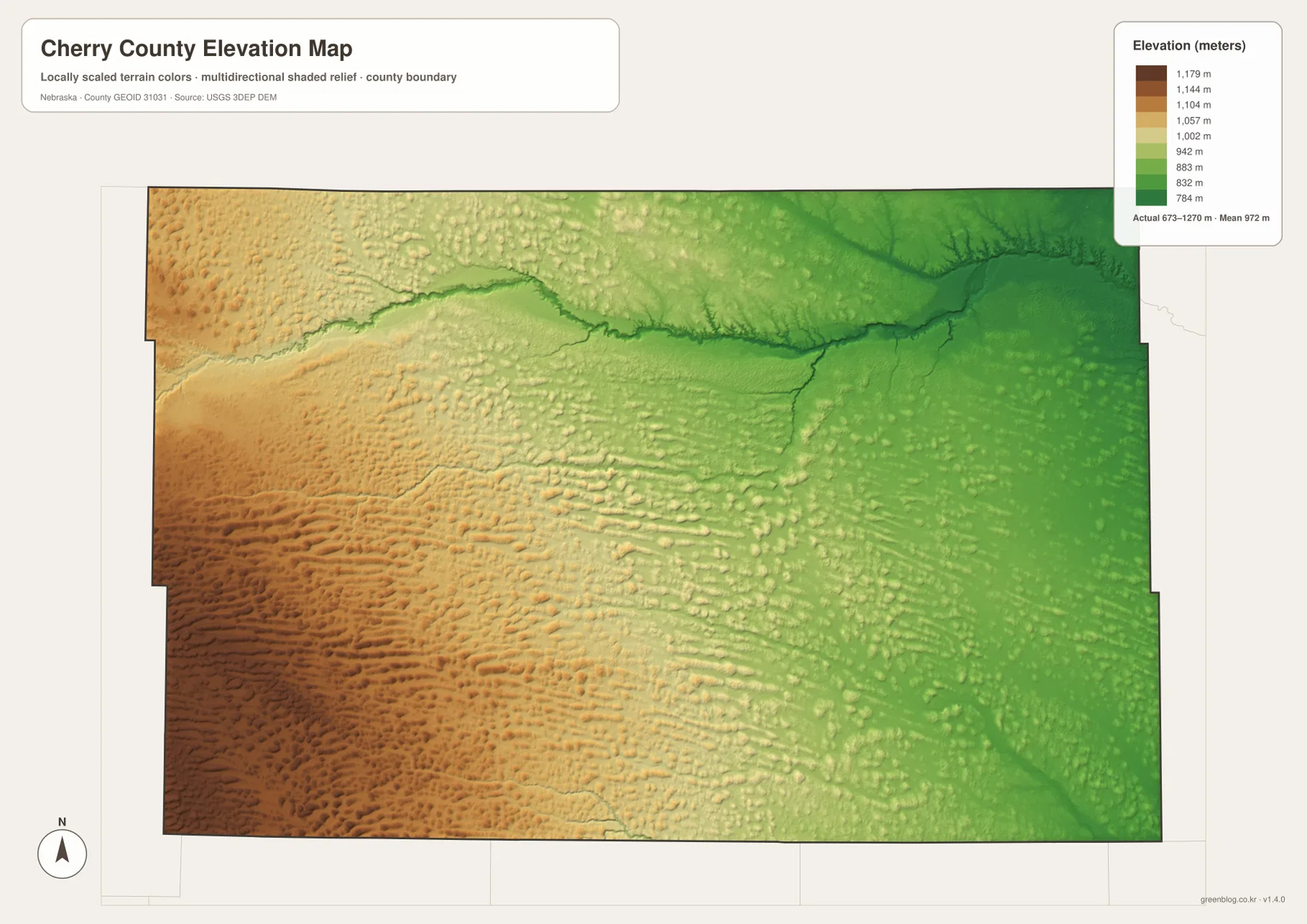
The elevation map reports an actual county-wide range of approximately 673 to 1,270 meters, with a mean near 972 meters. Greens dominate the Niobrara valley and much of the east, while yellow, tan, and brown terrain becomes more common toward the west and southwest. The total difference approaches 600 meters across the county.
The western and southwestern Sandhills consist of repeated elongated ridges rather than a single mountain mass. Low swales between those ridges contain small lakes, marshes, and stream channels. The far west contains some of the highest terrain, while the land gradually steps down toward Valentine and the eastern side.
The Niobrara forms the most dramatic low corridor, but the Snake River and North Loup River also stand out as green bands cutting through the uplands. Merritt Reservoir occupies the Snake River valley, and the surrounding lake country lies in lower spaces among the dunes. Comparing the water and elevation views makes the relationship between Sandhills relief and surface water particularly clear.
The colors are scaled locally for Cherry County and should be used to compare locations within this map. Similar shades on another county map may represent different absolute elevations. The generalized surface is not survey-grade information for engineering, construction, drainage design, or property work.
Merritt Reservoir sits inside one of the county’s richest lake landscapes
Merritt Reservoir lies southwest of Valentine in the Sandhills. Nebraska Game and Parks describes it as a major fishing, boating, and camping destination, fed by the Snake River and Boardman Creek. The park is also noted for dark skies and received International Dark Sky Park designation in 2022.
The clustered lakes east of Merritt connect visually with the nearby Valentine National Wildlife Refuge. The U.S. Fish and Wildlife Service says the refuge covers about 71,516 acres of Sandhills grassland, wetlands, lakes, marshes, and valleys. That mix helps explain why the water map contains so many named and unnamed lakes across the central-eastern interior.
East of Valentine, the Niobrara becomes a deep scenic valley
The Niobrara around Valentine is not simply a broad prairie river. National Park Service information describes the valley east of Valentine as roughly 200 to 300 feet deep and about one-half to two miles wide. Steep south-bank slopes, groundwater-fed tributaries, and numerous waterfalls give this part of Cherry County a much more dramatic relief than the surrounding Sandhills.
Fort Niobrara National Wildlife Refuge and Smith Falls State Park are part of the same broader river landscape. The supplied county map does not draw every recreation boundary, but the dense tributaries east of Valentine and the sharp green incision on the elevation map clearly show why this section of the Niobrara stands out.
Railroad-era settlement helped make Valentine the county center
Cherry County was organized in 1883, and Valentine was incorporated the following year. Historical records from Nebraska note that railroad construction in the early 1880s accelerated permanent settlement in a county that had previously been very sparsely populated. The northern corridor still contains nearly all of the county’s principal towns.
Today Valentine remains the county seat and the main service center for a very large rural area. West of Valentine, Cody, Merriman, Crookston, and Kilgore remain small communities along the northern transportation corridor, while the southern Sandhills contain enormous stretches of ranch country with few towns. The city and road maps make that imbalance easy to see.
Use U.S. 20 and the Niobrara as two simple anchors
For basic orientation, locate Valentine first and follow U.S. 20 west through Crookston, Kilgore, Nenzel, Cody, and Merriman. Then use U.S. 83 and Route 97 to move south into the Sandhills. The city map simplifies the same northern settlement pattern when minor roads are not needed.
For physical geography, begin with the Niobrara River, then move south to the Snake River and Merritt Reservoir, followed by the North Loup River and southern Loup branches. The elevation map adds the vertical picture by showing low river corridors against increasingly high western and southwestern Sandhills.
For printing or classroom display, the downloadable high-resolution JPG files preserve more road labels, lake names, and creek detail than the web previews. The county map emphasizes roads and settlements, the city map summarizes the principal towns, the water map highlights the river-and-lake network, and the elevation map shows the county’s large east-west relief change.
Frequently Asked Questions
Does the city map show distances from Valentine to Cody or Merriman?
No. The supplied city map ranks and locates Valentine, Cody, Kilgore, Merriman, Crookston, and Wood Lake, but it does not include connector lines or mileage. In such a large rural county, current road routing is a better source for actual driving distance and travel time.
Where is the lowest terrain in Cherry County?
The Niobrara River valley and much of the eastern side contain the lowest terrain. The county-wide elevation range is about 673 to 1,270 meters, with higher Sandhills becoming more common toward the west and southwest. The Snake and North Loup valleys also form lower corridors.
Can the Merritt Reservoir and lake map be used for water levels or flood decisions?
No. It is a geographic reference showing the Niobrara and Snake rivers, Merritt Reservoir, Sandhills lakes, and other waterways. Current reservoir levels, flood risk, water rights, property boundaries, and access conditions require current authoritative records.
Map File Information
The ZIP contains the original high-resolution JPG files for the Cherry County boundary and road map, city distribution map, terrain and water map, and elevation map.
- Included Files: Use only the versions confirmed in the article and supplied images
- File Type: Use the confirmed download contents
- Intended Use: Printing, education, presentations, and map-based projects
Related Maps
Sources and references
- Cherry County – About Our County
- National Park Service – Niobrara Natural Features
- Nebraska Game and Parks – Merritt Reservoir
- U.S. Fish & Wildlife Service – Valentine National Wildlife Refuge
- U.S. Census Bureau TIGER/Line Shapefiles
- USGS 3D Elevation Program
These maps are intended for geographic reference. For legal boundaries, land ownership, flood determinations, water rights, road conditions, construction, surveying, or other decisions requiring current authoritative information, consult Cherry County and the responsible state or federal agency.
Green Map creates custom-edited map images using open geographic data sources such as geoBoundaries, Natural Earth, OpenStreetMap, and government open data. These maps are edited visual materials, not raw data files, and are provided for education, documents, presentations, and graphic reference.