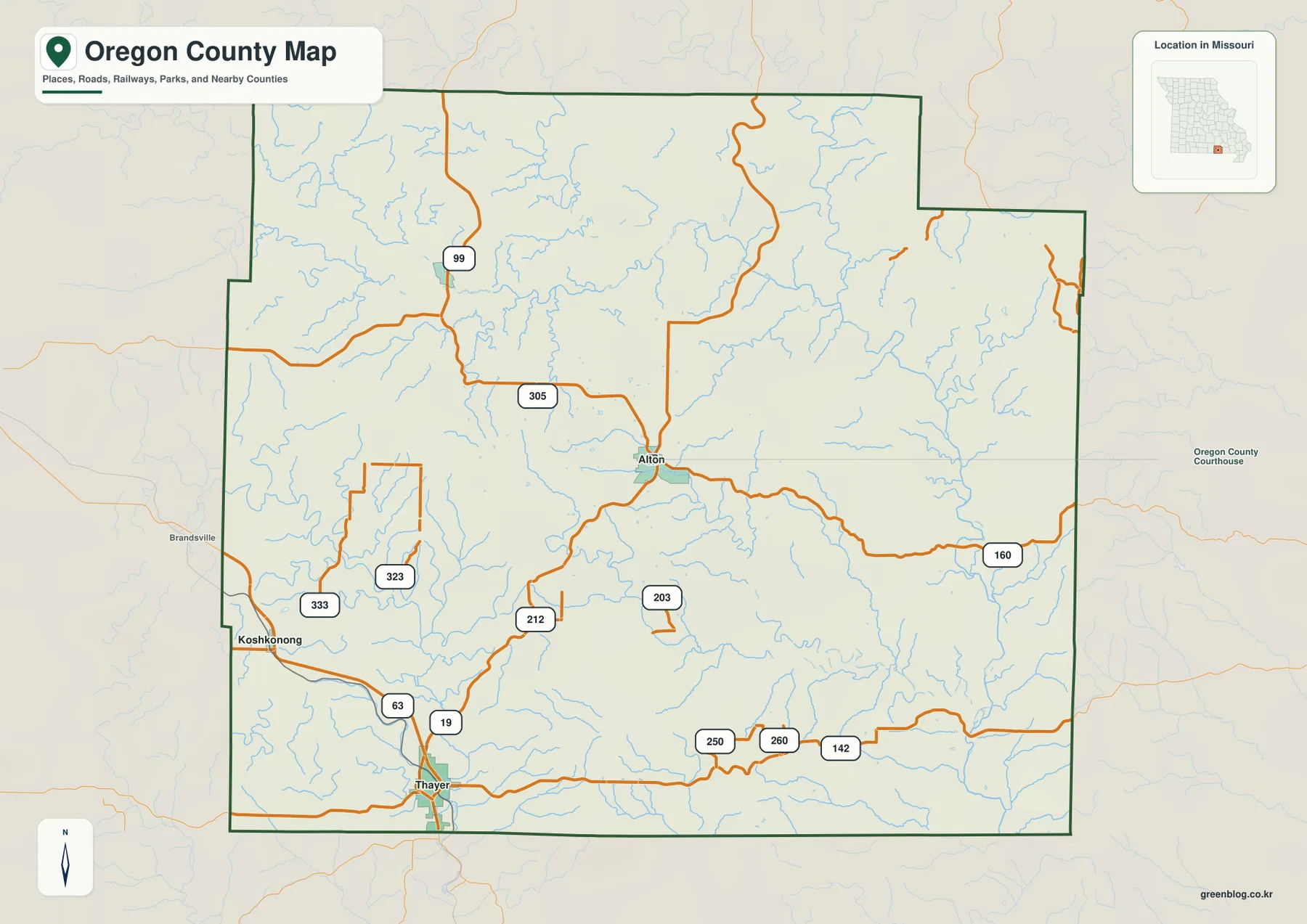
Oregon County lies along Missouri’s southern border, where the towns of Alton, Thayer, and Koshkonong sit among deeply cut Ozark hills and stream valleys. Route 19 links the Thayer area with Alton, U.S. 63 serves the southwest around Thayer and Koshkonong, and Route 160 crosses eastward from Alton. The Eleven Point River dominates the northern drainage, while the Spring River system occupies the southwest, giving the county two very different water-and-relief settings. High-resolution map files are available for download in the section below.
This page separates those features into a general county map, a city-connections map, a terrain-and-water map, and an elevation map. High-resolution JPG originals of all four can be downloaded together in one ZIP for closer inspection, A3 printing, classroom use, reports, or other large-format reference work.
Table of Contents
Alton and Thayer provide the clearest road framework
Alton is the easiest central reference on the general map, while Thayer anchors the southern edge near Arkansas. Route 19 connects the Thayer area northward toward Alton, and U.S. 63 passes through the Thayer and Koshkonong side of the county. Together those roads make the southwest much easier to orient before moving to smaller state routes.
Route 160 leaves Alton and crosses the eastern half of the county toward Ripley County. Routes 99 and 305 appear farther north and northwest, while 323 and 333 serve the Koshkonong side. South of Alton, Routes 212 and 203 connect additional rural areas, and Routes 250, 260, and 142 extend across the lower eastern part of the map.
The southern county line follows the Missouri-Arkansas border and is comparatively straight, but the northern and eastern outline includes several stepped segments. Inside the boundary, steep creek valleys often force roads to bend rather than follow long straight lines. That is especially noticeable when comparing the simple county outline with the much more intricate water and elevation maps.
The road between Thayer and Alton also crosses a noticeable change in relief. The southern river valleys sit lower, while the central county rises into rolling and locally steep terrain. East of Alton, Route 160 passes through a landscape cut by many tributaries, which helps explain why the road network becomes more winding in some sections.
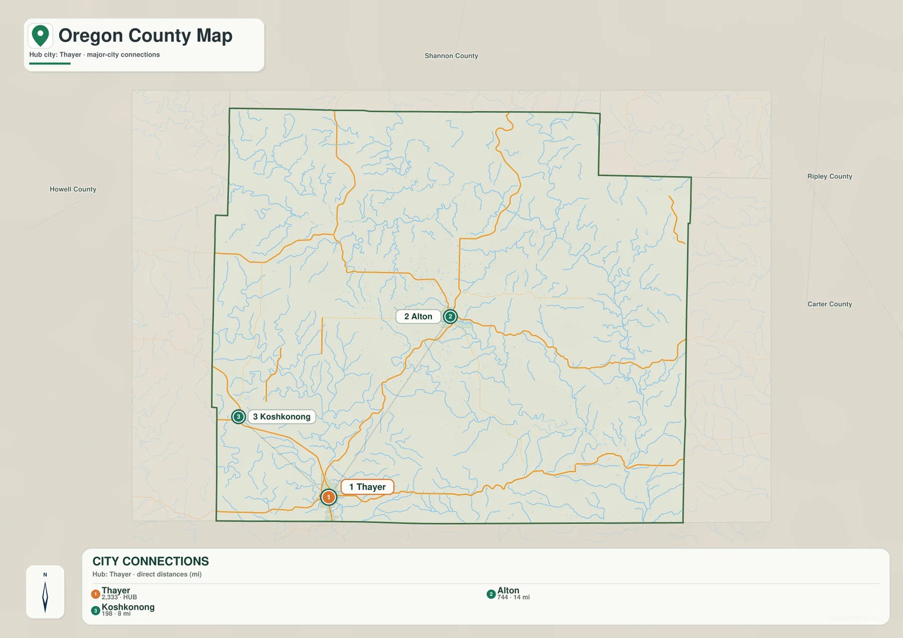
Thayer sits 8 miles from Koshkonong and 14 miles from Alton in straight-line distance
The city-connections map uses Thayer as its hub and highlights two additional communities. Koshkonong lies about 8 miles northwest of Thayer in straight-line distance, while Alton is roughly 14 miles to the north. Those measurements are direct point-to-point distances rather than driving mileage, so actual road travel is longer and follows a more winding route.
The three locations make a useful geographic triangle for the southern and central county. Thayer sits immediately north of the Arkansas line and along the U.S. 63 corridor. Koshkonong lies farther northwest, while Alton occupies a more central position where several state routes meet and spread toward the northern and eastern hills.
The connector lines on the city map are not intended to represent roads. Between Thayer and Alton, the landscape is crossed by ridges, small streams, and winding valleys, so a straight line does not show the actual route. The simplified map is best used to learn relative positions before consulting the detailed county map for roads.
Oregon County contains many smaller communities and rural places beyond these three labels, but the city map intentionally removes most of that detail. Remembering that Alton is north of Thayer and Koshkonong is northwest of Thayer gives a quick mental framework for reading the denser water and elevation maps.
Eleven Point River and Spring River occupy two distinct valley systems
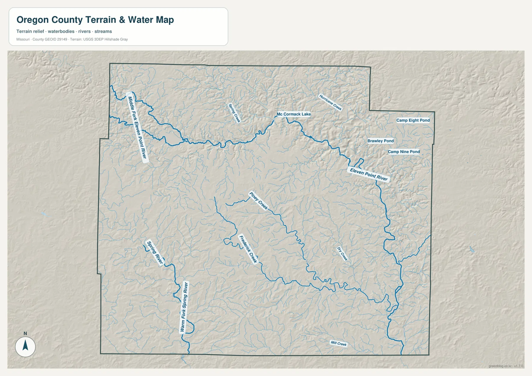
The Eleven Point River is the strongest water feature in the northern half of the terrain map. The Middle Fork Eleven Point River enters from the northwest and joins the main river, which then bends past the McCormack Lake area before continuing toward the east and southeast. Its valley is narrow and deeply cut compared with much of the surrounding upland.
Spring Creek and Hurricane Creek are labeled north of the main river, and several small named waters appear in the northeast, including Brawley Pond, Camp Eight Pond, and Camp Nine Pond. They are small features, but together with the tributaries they show how thoroughly the northern hills are divided by drainage lines.
The southwest has a different system built around the Spring River and Warm Fork Spring River. Those waterways occupy lower terrain around the Thayer and Koshkonong side of the county. Piney Creek and Frederick Creek run through the central interior, while Dry Creek and Mill Creek help define additional valleys farther east and southeast.
The terrain-and-water map is intended for geographic reference rather than current flood, depth, navigation, or property decisions. Stream levels and flood conditions can change, and the mapped water lines do not establish legal boundaries. For those questions, current official hydrologic or emergency-management information should be used.
Elevation ranges from about 107 to 331 meters
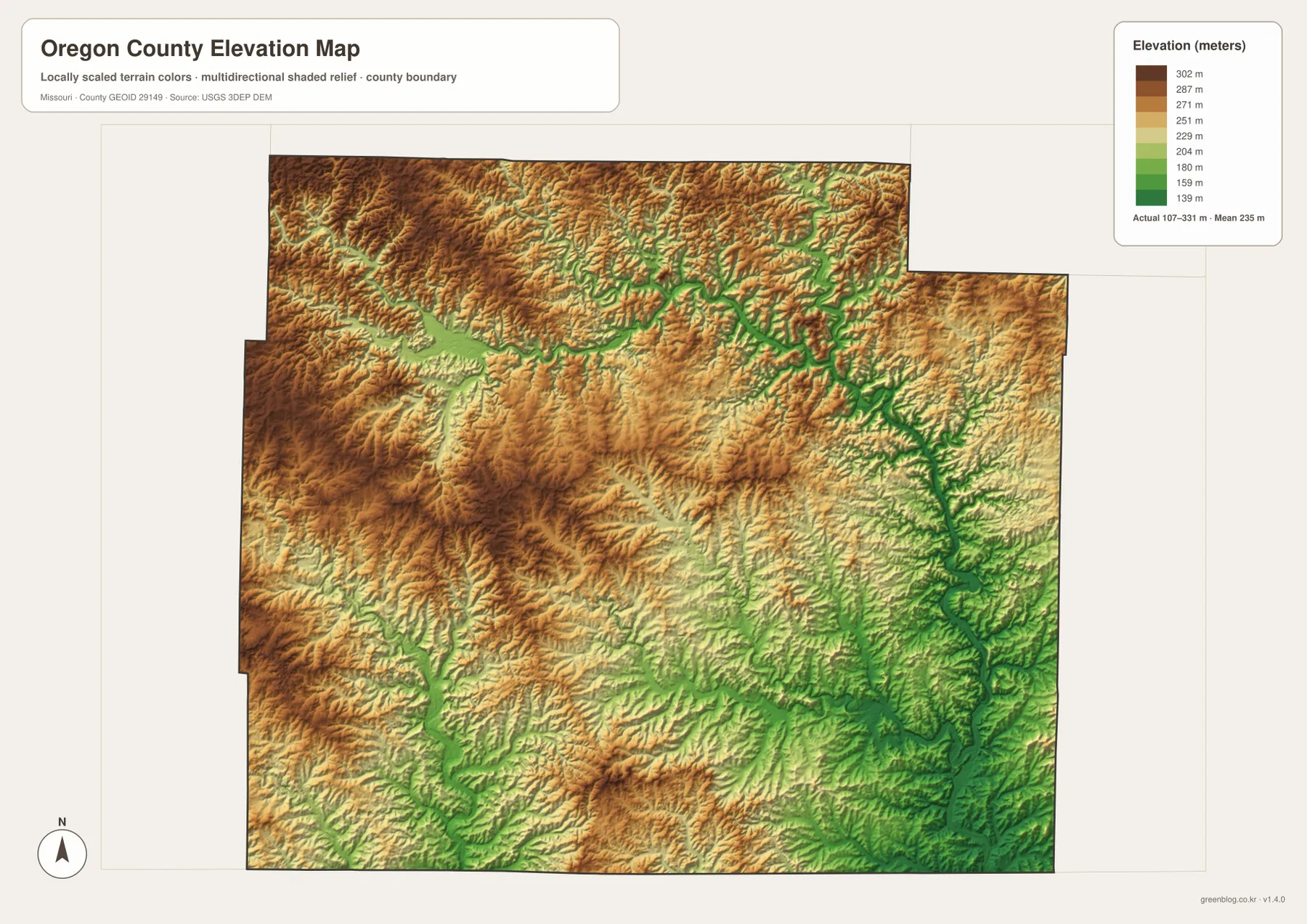
The elevation map reports an actual range of roughly 107 to 331 meters and a mean near 235 meters. Higher brown and dark tan terrain covers much of the northwest and north, but the Eleven Point River and its tributaries carve deep green corridors through those uplands. The rapid shift from ridge to valley is one of the most distinctive features on the map.
Lower terrain becomes more extensive toward the east and southeast, where green colors spread across broader valley floors. The Eleven Point River drops into a pronounced low corridor as it continues eastward, and tributary valleys branch away from it. The Spring River side in the southwest is also low, though its valley pattern is broader and less sharply enclosed than parts of the northern river system.
The central county is a mix of ridges and creek-cut hollows. Piney Creek and Frederick Creek occupy lower strips that can be traced directly from the terrain map to the elevation map, while higher ground remains between them. This alternating pattern explains why roads often curve through the interior instead of following a simple grid.
This county-scale elevation surface is useful for comparing broad relief, not for engineering, construction, drainage design, parcel-level elevation decisions, or survey-grade measurements. Site-specific work requires more detailed official elevation data or field surveying.
Use each map for a different part of the county story
Start with the general county map when roads and settlement locations matter most. Alton, Thayer, and Koshkonong provide a simple geographic framework, and Routes 19, 63, and 160 make the main travel directions easy to identify. The city map is faster when you only need the relative position and straight-line distance among the three highlighted communities.
For rivers and terrain, the water map carries much more detail. Locate the Eleven Point River in the north and the Spring River system in the southwest, then follow smaller features such as Piney Creek, Frederick Creek, and Dry Creek. Moving to the elevation map afterward shows how those waterways occupy lower corridors between higher ridges.
The contrast between the northern hills and the lower east and southeast is easiest to understand when the water and elevation maps are viewed together. Deep tributary valleys cut through the uplands, while larger low areas open around the major river systems. This combination is one reason Oregon County’s roads and settlement pattern differ from flatter Missouri counties.
The downloadable JPG originals contain more pixels than the WebP previews on the page, making them better for enlargement, A3 printing, classroom handouts, reports, and personal reference. They remain general-purpose maps, however. Legal boundaries, land ownership, live road restrictions, flood status, and precise site elevations should always be checked against the appropriate current official source.
Frequently Asked Questions
How far are Alton and Koshkonong from Thayer on the city map?
The map shows straight-line distances of about 14 miles from Thayer to Alton and about 8 miles from Thayer to Koshkonong. These are direct distances rather than driving mileage, so real road trips are longer.
How much elevation change is shown across Oregon County?
The elevation map shows an actual range of about 107 to 331 meters and a mean near 235 meters. Higher terrain is concentrated in the northwest and north, while major river valleys and much of the southeast are lower.
Which rivers are the best starting points on the terrain map?
The Eleven Point River is the strongest reference in the north, and the Spring River with the Warm Fork Spring River provides the clearest southwest reference. Smaller creeks can then be located between those two major systems.
Map File Information
The download ZIP contains high-resolution JPG versions of the Oregon County general map, city map, terrain-and-water map, and elevation map.
- File Type: JPG
Related Maps
Sources and References
Boundary and road reference data are supported by U.S. Census Bureau TIGER/Line, water features by USGS National Hydrography, and elevation data by the USGS 3D Elevation Program. These maps are general geographic references and are not substitutes for legal surveys or current operational data.
Green Map creates custom-edited map images using open geographic data sources such as geoBoundaries, Natural Earth, OpenStreetMap, and government open data. These maps are edited visual materials, not raw data files, and are provided for education, documents, presentations, and graphic reference.