Lancaster County is easiest to recognize by Lincoln, but the county changes character quickly beyond the capital’s built-up area. Northwest of the city, Branched Oak Lake sits among rolling hills near Raymond and Malcolm. To the south, Hickman and Firth are surrounded by farmland and creek valleys, while Waverly and Bennet mark different sides of the eastern rural belt. I-80, U.S. 77, U.S. 6 and 34, and Nebraska Highway 2 provide the main road framework. This page follows those routes into the county’s water and elevation patterns, and the original high-resolution JPG map files can be downloaded together in one ZIP archive.
The contrast between metropolitan Lincoln and the outer county is one of Lancaster County’s defining features. Salt Creek passes through the city and connects to a dense network of smaller streams, while reservoirs such as Branched Oak, Pawnee, Bluestem, and Stagecoach provide strong landmarks outside the urban core. Elevation ranges from about 327 to 464 meters, with higher ground common in the northwest and southwest and lower corridors running through Lincoln and toward the northeast.
Table of Contents
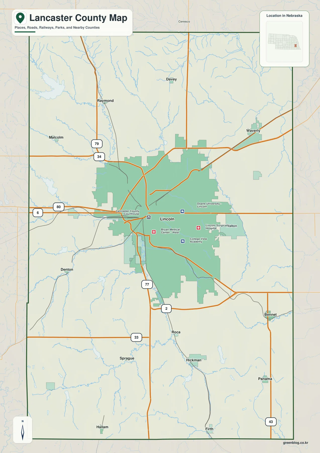
Lincoln makes the county road network easier to understand
Lincoln is both the Lancaster County seat and Nebraska’s capital, so it naturally dominates the general county map. I-80 passes north of the central city, U.S. 77 creates the strongest north–south route, and U.S. 6 connects western and eastern approaches. U.S. 34 is useful for locating Raymond and Malcolm to the northwest, while Nebraska Highway 2 leads southeast from Lincoln toward Bennet and the rural edge of the county.
The smaller communities form a broad ring rather than a single corridor. Waverly is northeast of Lincoln near U.S. 6, Hickman lies south of the city, and Bennet occupies the southeast. Malcolm and Raymond point toward the reservoir country in the northwest, while Firth and Hallam help orient the far southern side. Once Lincoln is fixed as the center, these places are easier to remember by direction than by trying to follow every local road.
Urban landmarks such as the university, hospitals, and courthouse fill much of the Lincoln footprint, but the county-scale map is most useful for showing where the city gives way to open land. I-80, U.S. 77, U.S. 6, and Highway 2 act as practical reference lines that connect the metropolitan core with the smaller communities beyond it.
Population is concentrated in Lincoln, but the outer towns define different parts of the county
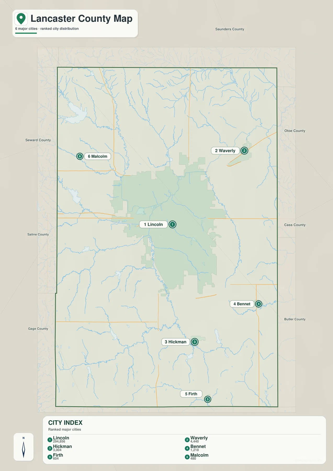
The supplied city map lists Lincoln first, followed by Waverly, Hickman, Bennet, Firth, and Malcolm. Its printed index values are 294,856 for Lincoln, 4,440 for Waverly, 3,004 for Hickman, 2,218 for Bennet, 604 for Firth, and 480 for Malcolm. These figures are part of the map and are most useful for relative comparison; current population counts should be checked against recent Census or city data.
The distribution shows more than a size gap. Waverly represents the northeast side, Hickman the south, Bennet the southeast, Malcolm the northwest, and Firth the far south. Each sits in a different landscape of roads, creeks, farmland, and reservoirs. Lancaster County therefore has a very large urban center without becoming a continuously urban county from edge to edge.
This is especially clear northwest of Lincoln, where Malcolm and Raymond lead toward Branched Oak Lake and higher rolling terrain. South of the city, Hickman and Firth sit amid more open agricultural land and small drainage channels. The city map strips away much of the road detail, making these directional relationships easier to see.
Salt Creek connects the urban core with lower ground to the north
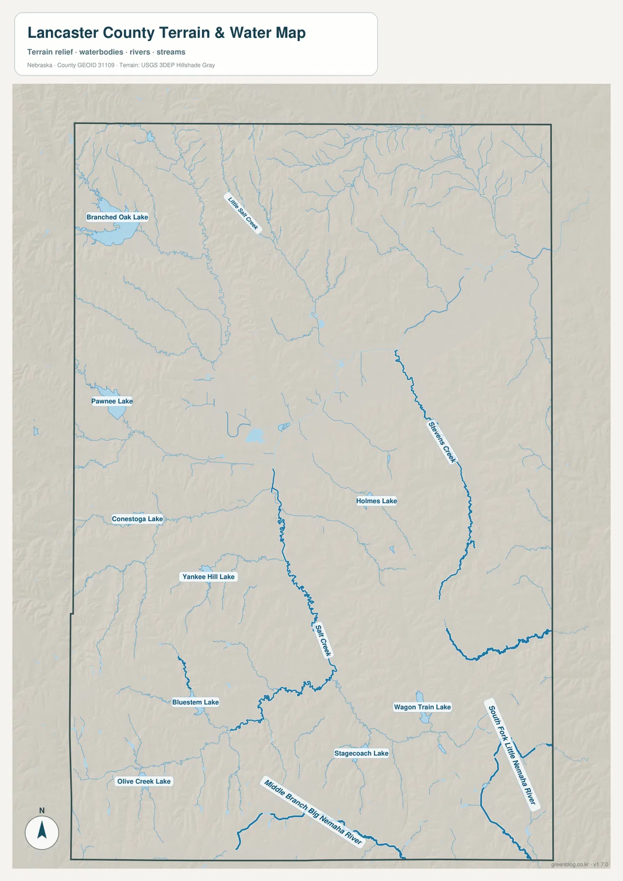
Salt Creek is the main water reference through central Lancaster County. It passes through the Lincoln area, receives numerous smaller tributaries, and continues north through lower terrain. Lincoln’s official history also connects early settlement with the Salt Creek area and its saline environment, giving the stream both geographic and historical significance.
North of Lincoln, Little Salt Creek follows another long low corridor near Davey and east of Raymond. Stevens Creek cuts through the eastern part of the county, while the South Fork Little Nemaha River appears farther southeast. Along the southern edge, the Middle Branch Big Nemaha River adds another drainage direction. The county is therefore divided among several creek systems rather than organized around one large river.
The water and elevation maps match closely. Salt Creek, Little Salt Creek, and Stevens Creek occupy greener low ground, while farmland between them rises into broad rolling ridges. That relationship explains why some outer roads and towns sit on higher ground even when they are only a short distance from Lincoln.
Branched Oak Lake gives the northwest a landscape unlike central Lincoln
Branched Oak Lake is the most prominent reservoir in the county. It lies northwest of Lincoln near Raymond, and Nebraska Game and Parks describes Branched Oak State Recreation Area as containing the largest lake in eastern Nebraska, with roughly 1,800 acres of water. The reservoir sits among higher rolling terrain and provides an immediate visual contrast with the flatter, heavily developed parts of Lincoln.
Other reservoirs help divide the outer county into recognizable areas. Pawnee Lake is in the western half, Conestoga Lake is west of Lincoln, and Yankee Hill, Bluestem, and Olive Creek lakes lie to the southwest. Holmes Lake sits within southeastern Lincoln, while Wagon Train and Stagecoach lakes mark the rural southeast. They are separate reservoirs in different small watersheds, not one connected lake system.
Thinking of the lakes by direction is more useful than memorizing a list: Branched Oak northwest of Lincoln, Conestoga west, Bluestem southwest, Holmes inside the city, and Wagon Train and Stagecoach southeast. Current water levels and recreation access can change, so visitors should check the latest information from the managing agency.
A 327–464 meter range separates western hills from Lincoln’s lower corridors
The elevation map places Lancaster County between about 327 and 464 meters, with a mean near 393 meters. Higher brown and orange terrain is common in the northwest and southwest, while Lincoln and much of the northeast appear lower and greener. The county-wide difference of roughly 137 meters is enough to produce a clear pattern of rolling uplands and stream-cut valleys.
The Branched Oak area shows that contrast particularly well. Higher hills surround the reservoir and its tributaries, while lower channels cut into the terrain. West of Lincoln around Raymond and Malcolm, the surface is more strongly dissected than the broad urban core. Similar high ground appears southwest around Denton and Hallam.
Lincoln and the Waverly side of the county are lower overall, and Stevens Creek follows another long green corridor in the east. Farther southeast near Bennet and Panama, the land rises again into rolling hills. Lancaster County is therefore better understood as a series of uplands separated by lower creek corridors than as a simple slope in one direction.
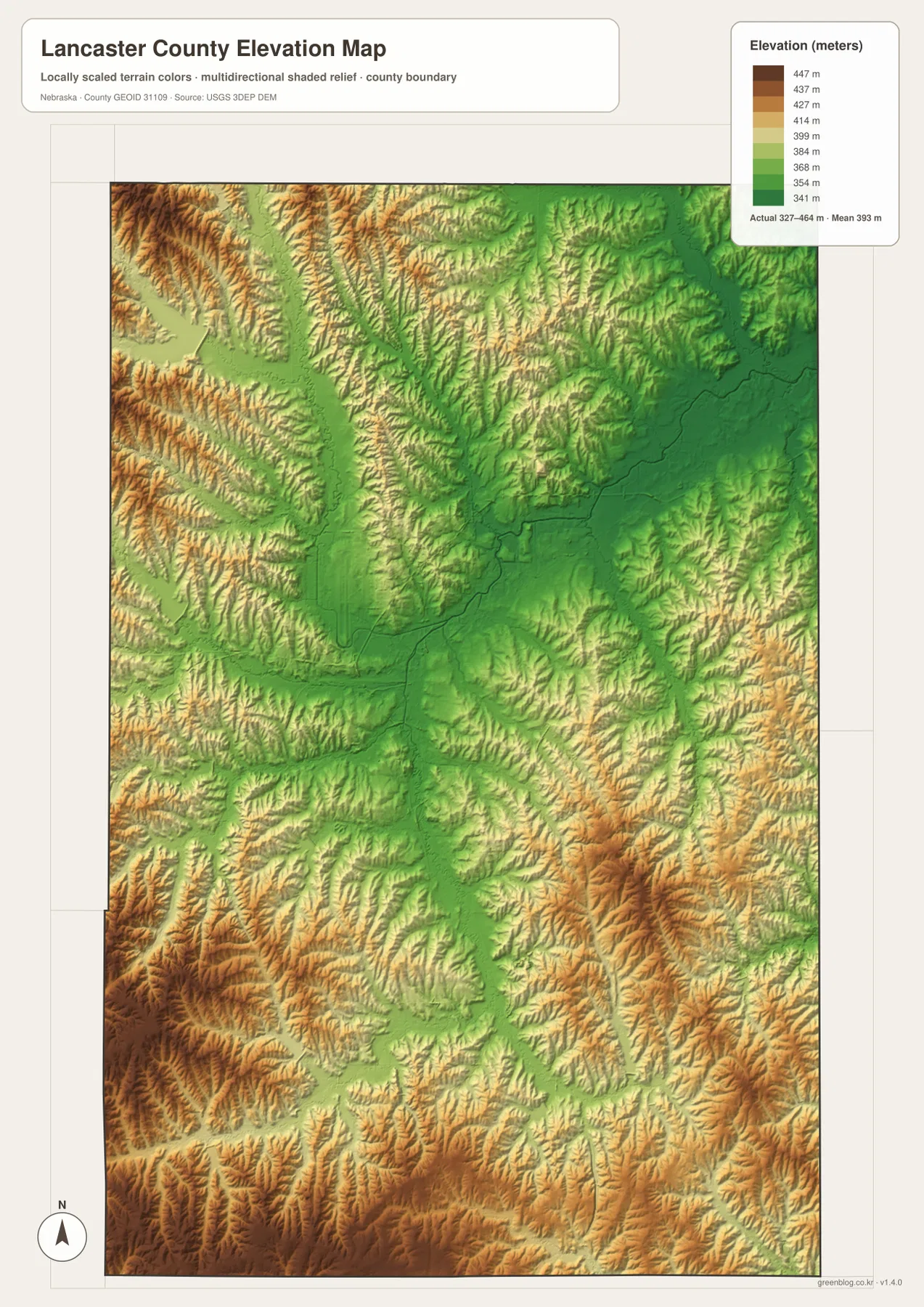
This elevation surface is generalized for county-scale comparison. It is not survey-grade information for a parcel, building site, drainage plan, road grade, or engineering project. Those tasks require current detailed elevation data such as the USGS 3D Elevation Program and, where appropriate, professional measurements.
The county changes from capital city to reservoir and farm country within a short drive
Lincoln’s size strongly shapes Lancaster County, but it does not describe the entire county. Northwest toward Raymond and Malcolm, reservoir hills and open farmland replace the metropolitan street pattern. South toward Hickman and Firth, agricultural land and tributary valleys become more important than urban landmarks. East toward Waverly and Bennet, creek corridors divide another broad rural landscape.
This rapid transition is why the four map views complement one another. The city map emphasizes how concentrated the population is in Lincoln, while the water and elevation maps reveal how much rural terrain remains outside the urban core. The general county map then ties those landscapes back to the roads people actually use.
Lancaster County can therefore be understood as two connected settings rather than one uniform place: a large metropolitan center and a surrounding county of reservoirs, farmland, small towns, and creek valleys. Lincoln is the starting point, but the outer landscape gives the county much of its geographic variety.
Pick the map that matches the question you are trying to answer
Use the general county map when the goal is to locate Lincoln, Waverly, Hickman, Bennet, Malcolm, I-80, U.S. 77, U.S. 6 and 34, and Highway 2. The city-distribution map is better for a quick comparison of Lincoln’s scale with the five smaller ranked communities around it.
For natural features, the terrain-and-water map provides the names and locations of Salt Creek, Little Salt Creek, Stevens Creek, Branched Oak Lake, and the county’s smaller reservoirs. The elevation map answers a different question by showing where the hills and lower corridors are. Comparing the water and elevation versions makes it easy to see why many streams follow the green lowlands.
A useful study sequence is to locate Lincoln and the main highways first, trace Salt Creek and the reservoirs next, and then compare the same places on the elevation surface. The WebP images on the page are quick previews, while the original JPG files are better for enlarging small labels or printing. Legal boundaries, flood decisions, current road conditions, reservoir access, surveying, and engineering work should rely on the latest authoritative source for the specific task.
Frequently Asked Questions
Where can I see the clearest contrast between Lincoln and rural Lancaster County?
The northwest around Branched Oak Lake, Raymond, and Malcolm is a good example. The landscape changes from Lincoln’s urban street network to rolling hills, reservoir shorelines, farmland, and rural roads within a relatively short distance.
Where does Salt Creek run through Lancaster County?
Salt Creek passes through the Lincoln area and continues north, receiving several smaller tributaries. On the elevation map it follows a lower green corridor, making it one of the best natural reference lines for understanding central Lancaster County.
Can the 327–464 meter elevation range be used for surveying or construction?
No. The range is a generalized county-scale summary. Parcel surveys, construction, drainage design, and road engineering require current detailed elevation data and professional measurements rather than this regional reference map.
Map File Information
The county, city-distribution, terrain-and-water, and elevation maps described on this page are available together in one ZIP file. It contains four original high-resolution JPG maps suitable for detailed viewing and printing.
- Included Files: County map, city-distribution map, terrain-and-water map, elevation map
- File Type: JPG files in a ZIP archive
Related Maps
Sources and references
These official and public sources provide additional context for Lancaster County government, Lincoln, Branched Oak Lake, administrative boundaries, waterways, and elevation.
- Lancaster County, Nebraska official website – county government and local information
- City of Lincoln – About Us – capital-city and local history information
- Nebraska Game and Parks – Branched Oak – lake and State Recreation Area information
- U.S. Census Bureau TIGER/Line – administrative boundary data
- USGS National Hydrography – river and stream data
- USGS 3D Elevation Program – elevation data
Green Map creates custom-edited map images using open geographic data sources such as geoBoundaries, Natural Earth, OpenStreetMap, and government open data. These maps are edited visual materials, not raw data files, and are provided for education, documents, presentations, and graphic reference.