Howard County lies in central Nebraska, where St. Paul sits near the meeting of U.S. 281 and Nebraska Highway 92 and the broad Loup River lowlands contrast with deeply cut hills to the west. Smaller communities such as Dannebrog, Elba, Cushing, Farwell, and Howard City (Boelus) are spread along different roads and drainage corridors instead of forming one continuous settlement belt. This page compares the county boundary and highway network, the six-city distribution, the North Loup–Loup river system and its tributaries, and an elevation range of about 522 to 662 meters. Four original high-resolution JPG maps can also be downloaded together in a ZIP file for printing or closer study. High-resolution map files are available for download in the section below.
The easiest way to understand Howard County is to start with St. Paul and then follow the river valleys outward. St. Paul is slightly east of the county’s center, near a broad low area where major drainage lines converge. West and northwest of that lowland, narrow creeks have cut a dense pattern of ridges and valleys into higher ground. The southeast is lower and more open by comparison. Moving between the road, water, and elevation maps shows why the main communities and highways occupy different corridors rather than following a single straight line across the county.
Table of Contents
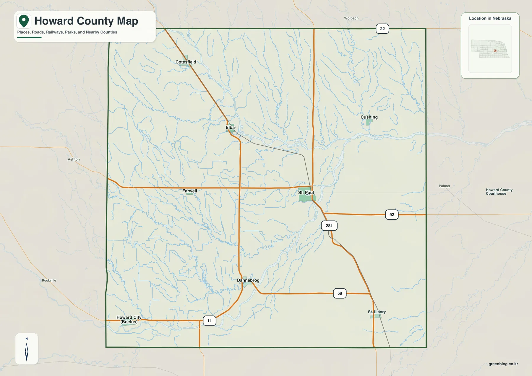
St. Paul ties U.S. 281 to Highway 92 at the center of the county road network
St. Paul is the clearest anchor on the general county map. U.S. 281 runs north–south through the area, while Nebraska Highway 92 crosses east–west, giving readers an immediate reference for the rest of Howard County. Elba lies to the northwest, Cotesfield is farther north, and Cushing sits to the northeast near the Loup River corridor. South of St. Paul, Dannebrog appears where local and state routes converge, while St. Libory is closer to the southeastern edge.
Dannebrog is near the junction of Highways 11 and 58. Highway 58 continues east toward U.S. 281, while Highway 11 provides a route toward Howard City (Boelus) in the southwest and back north toward Elba. Farwell lies west of St. Paul near Highway 92, making it a useful marker between the county seat and the more rugged western half. Highway 22 crosses near the northern boundary, but most of the named communities on the supplied map sit farther south, closer to the main river valleys and the central road network.
The surrounding counties help place Howard County within central Nebraska. Greeley County borders it on the north, Sherman County on the west, Buffalo County at the southwest, Hall County on the south, and Merrick County on the east. Nance and Valley counties appear nearby on the broader map but do not share a direct county boundary with Howard County. The administrative outline is fairly regular, yet the terrain inside it is not: the western half is dissected by many short drainage valleys, while the eastern side opens into lower ground associated with the Loup River.
St. Paul stands well above five smaller communities in the six-city index
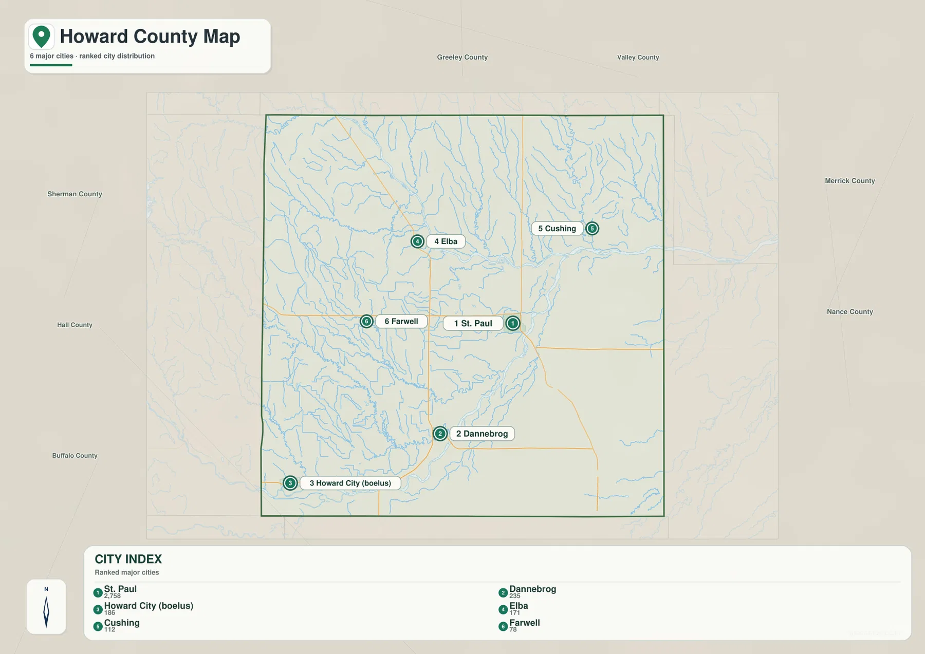
The city-distribution map ranks six communities: St. Paul first, Dannebrog second, Howard City (Boelus) third, Elba fourth, Cushing fifth, and Farwell sixth. The ranking is best treated as a map index rather than an administrative hierarchy. Its main value is spatial. St. Paul is near the east-central part of the county, Dannebrog and Howard City are farther south and southwest, Elba and Farwell lie to the west, and Cushing occupies the northeastern side close to the main river corridor.
The printed index lists St. Paul at 2,758, Dannebrog at 235, Howard City (Boelus) at 186, Elba at 171, Cushing at 112, and Farwell at 78. These figures are part of the supplied map and should not be treated as live population totals; current demographic work should use the latest Census release. As a visual comparison, however, the numbers show how strongly St. Paul stands out from the other named centers. The remaining communities are small and widely separated, so understanding their road and river setting matters more than memorizing their rank alone.
St. Paul is also the county seat. Howard County’s official site identifies the city as the administrative center, and the county’s comprehensive plan describes it as a central community served by U.S. 281 and the main state highways. The other towns occupy distinct geographic settings. Elba is closer to the North Loup side of the county, Cushing is near the eastern Loup corridor, and Dannebrog is tied to the southern highway network. That variety makes the city sheet useful when it is compared directly with the general and water maps.
The North Loup and Loup River lowlands open a broad corridor across the east
The water-and-terrain map is organized around the North Loup River and the Loup River. The North Loup enters from the northwest, bends through the northern half of the county, and approaches a broad lowland near St. Paul. Farther east, the Loup River is shown as a major channel leaving the county. The main valley is much wider and flatter than the creek-cut country to the west, which is why the water map and elevation map produce such a strong visual contrast in the same part of Howard County.
Several northern and northeastern tributaries descend toward that larger system. Council Creek, Cady Creek, and Spring Creek run through narrow valleys before reaching the main lowland, while Munson Creek approaches the North Loup from the west. Farther south, Turkey Creek and Oak Creek wind eastward across the interior, and Lake Creek follows a long north–south corridor on the eastern side. These smaller channels explain the branching pattern visible in the shaded terrain, especially where the western uplands are broken into narrow ridges.
The South Loup River provides a separate reference near the southern boundary. It runs across the lower edge of the county rather than through the St. Paul–Loup River lowland. Howard City (Boelus) and the Dannebrog area are easier to place when the South Loup, Oak Creek, and Turkey Creek are considered together. This is one of the most useful features of the water map: northern, central, and southern Howard County are not drained by one simple channel but by several connected river and creek corridors occupying different parts of the landscape.
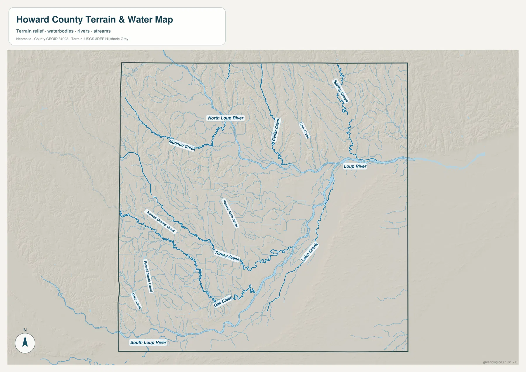
This map is a geographic reference for water features, not a flood map, parcel map, or real-time river product. Stream lines do not indicate current discharge, channel depth, public access, or legal boundaries. Conditions can change with weather and season, and detailed safety or regulatory questions require current information from the appropriate agency. For county-scale study, the map is most useful for showing how many smaller valleys feed the main river system.
Farwell-area canals add another layer to the creek network in western Howard County
Western Howard County contains more than natural streams. Around Farwell, the water map labels the Farwell Central Canal, Farwell Main Canal, and Farwell South Canal. These channels cross a rural area already divided by creek valleys, so the map becomes much more detailed here than the general road sheet suggests. Farwell is a small community, but the surrounding canal names make it an effective landmark when comparing the road and water maps.
Munson Creek, Turkey Creek, and Oak Creek help explain the shape of the western uplands. Each follows a lower path between the higher ridges and gradually connects toward larger drainage corridors. On the elevation map, those valleys appear as greener strips cutting into tan and brown terrain. The relationship is especially clear around Turkey Creek and Oak Creek, where the water lines and low shaded bands trace similar curves through the interior of the county.
The canal labels should not be interpreted as current operational maps. The supplied image does not show water-delivery schedules, ownership, maintenance status, or legal access, and the generalized county scale cannot represent the width of every channel. For regional orientation, however, the canal-and-creek pattern is valuable because it shows that the western side is crossed by a dense water network rather than being one continuous block of upland.
Elevation drops from 662-meter western ridges toward the lower Loup River valley
The supplied elevation map gives a county-wide range of roughly 522 to 662 meters, with a mean near 585 meters. The highest brown terrain is concentrated in the west and northwest, where narrow ridges and short valleys create a strongly textured surface. East of St. Paul, the Loup River corridor becomes broad and green, marking some of the lowest terrain in the county. The difference between the mapped minimum and maximum is about 140 meters, enough to produce a clear change from rugged western hills to lower eastern plains and valleys.
The northwest shows the most tightly packed relief. Small tributary valleys extend eastward and southeastward from higher ridges until they reach the North Loup lowland, where the terrain opens noticeably. Similar but somewhat lower uplands continue through the west-central and southwestern parts of the county. Turkey Creek and Oak Creek cut visible low passages across those hills, matching the same stream courses labeled on the water map.
Eastern Howard County is lower overall, but it is not completely flat. The Loup River and Lake Creek occupy broad green corridors, while Spring Creek and other tributaries divide the northeastern surface into smaller ridges. The southeast is smoother and lower than much of the west, producing one of the strongest contrasts on the map. A simple “west high, east low” summary is useful, but the shaded relief adds an important detail: the transition happens through many creek-cut valleys rather than through one continuous slope.
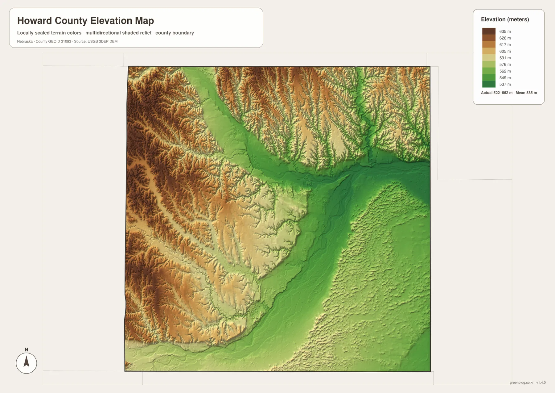
The elevation surface is generalized for county-scale comparison and should not be treated as survey-grade measurement. Parcel elevations, drainage design, road engineering, construction, and other technical work require current high-resolution data such as the USGS 3D Elevation Program and, when necessary, professional field measurements. For regional geography, the 522–662 meter range clearly explains why streams, towns, and roads occupy different parts of the county.
Dannebrog, Elba, and Cushing sit in different road-and-river settings
Overlaying the settlement pattern with the river network makes the smaller communities easier to remember. Elba is in the northwest near Highway 11 and the North Loup side of the county, while Cushing lies farther east close to the Loup River and several tributary valleys. Dannebrog is south of St. Paul near Highways 11 and 58, and Howard City (Boelus) is farther southwest near the South Loup system. Each place belongs to a different corridor, which is why no single highway or river explains the whole county.
Farwell is another useful example. It lies west of St. Paul near Highway 92, but the water map adds a second identity through the nearby Farwell canals. St. Paul combines the strongest roles: county seat, U.S. 281 crossing, Highway 92 connection, and proximity to the broad Loup River lowland. Howard County’s official comprehensive plan identifies U.S. 281 and State Highways 11, 58, and 92 as the primary road network, which matches the way the supplied county map connects the main communities.
A county map is not a substitute for current navigation, but it is excellent for learning relative direction. A trip from St. Paul toward Elba follows a different corridor than a trip toward Dannebrog, and Cushing or St. Libory make more sense when U.S. 281 and the eastern river valley are used as references. Linking the towns to roads and drainage is more memorable than treating each community as an isolated dot.
Use the map that matches whether you need towns, water, or relief
The general county map is the best starting point for St. Paul, neighboring communities, numbered highways, and adjacent counties. The city-distribution sheet removes much of that detail and emphasizes the six ranked communities, making the large difference between St. Paul and the smaller towns immediately visible. Looking at those two maps first provides enough orientation to make the water and elevation sheets easier to interpret.
For rivers and drainage, the terrain-and-water map is the more useful choice. It labels the North Loup, Loup, and South Loup rivers as well as creeks and the Farwell-area canals that are not prominent on the basic map. The elevation map answers a different question by showing where the county is higher or lower. Placed side by side, the two maps show that the river corridors and creek valleys follow lower green terrain between the higher western ridges.
The WebP images on the page are optimized as previews. The original JPG files are better when small labels need to be enlarged or when the maps will be printed. All four remain general-reference products, so legal boundaries, property ownership, flood decisions, live road conditions, surveying, and engineering should use the current authoritative source for the specific task.
Frequently Asked Questions
What is the county seat of Howard County, Nebraska?
St. Paul is the county seat. Howard County’s official website and comprehensive plan identify it as the administrative center. On the maps, St. Paul is also the most practical orientation point because U.S. 281 and Highway 92 meet there close to the broad Loup River lowland.
How are the North Loup River and Loup River shown on the map?
The North Loup River enters from the northwest and bends toward the broad lowland north and east of St. Paul. Farther east, the Loup River is labeled as the major channel leaving the county. The South Loup River is separate from those northern and central corridors and runs near the southern boundary.
Can the 522–662 meter elevation map be used for surveying or construction?
No. The map is a generalized county-scale surface intended to compare high western hills with the lower Loup River corridor. Parcel surveys, building design, drainage work, and road engineering require current detailed elevation data and professional measurements rather than this regional reference map.
Map File Information
The county, city-distribution, terrain-and-water, and elevation maps described on this page are available together in one ZIP file. It contains four original high-resolution JPG maps suitable for printing and detailed viewing.
- Included Files: County map, city-distribution map, terrain-and-water map, elevation map
- File Type: JPG files in a ZIP archive
Related Maps
Sources and references
These official and public sources provide additional context for Howard County government, roads, local history, administrative boundaries, waterways, and elevation. The maps on this page are simplified for regional reference, so legal, engineering, and current-condition decisions should be checked against the original authoritative data.
- Howard County, Nebraska official website – county government and community information
- Howard County & Communities Comprehensive Plan – St. Paul, primary highways, and Loup River Valley context
- U.S. Census Bureau TIGER/Line – administrative boundary and geographic reference data
- USGS National Hydrography – river and stream data
- USGS 3D Elevation Program – elevation data
Green Map creates custom-edited map images using open geographic data sources such as geoBoundaries, Natural Earth, OpenStreetMap, and government open data. These maps are edited visual materials, not raw data files, and are provided for education, documents, presentations, and graphic reference.