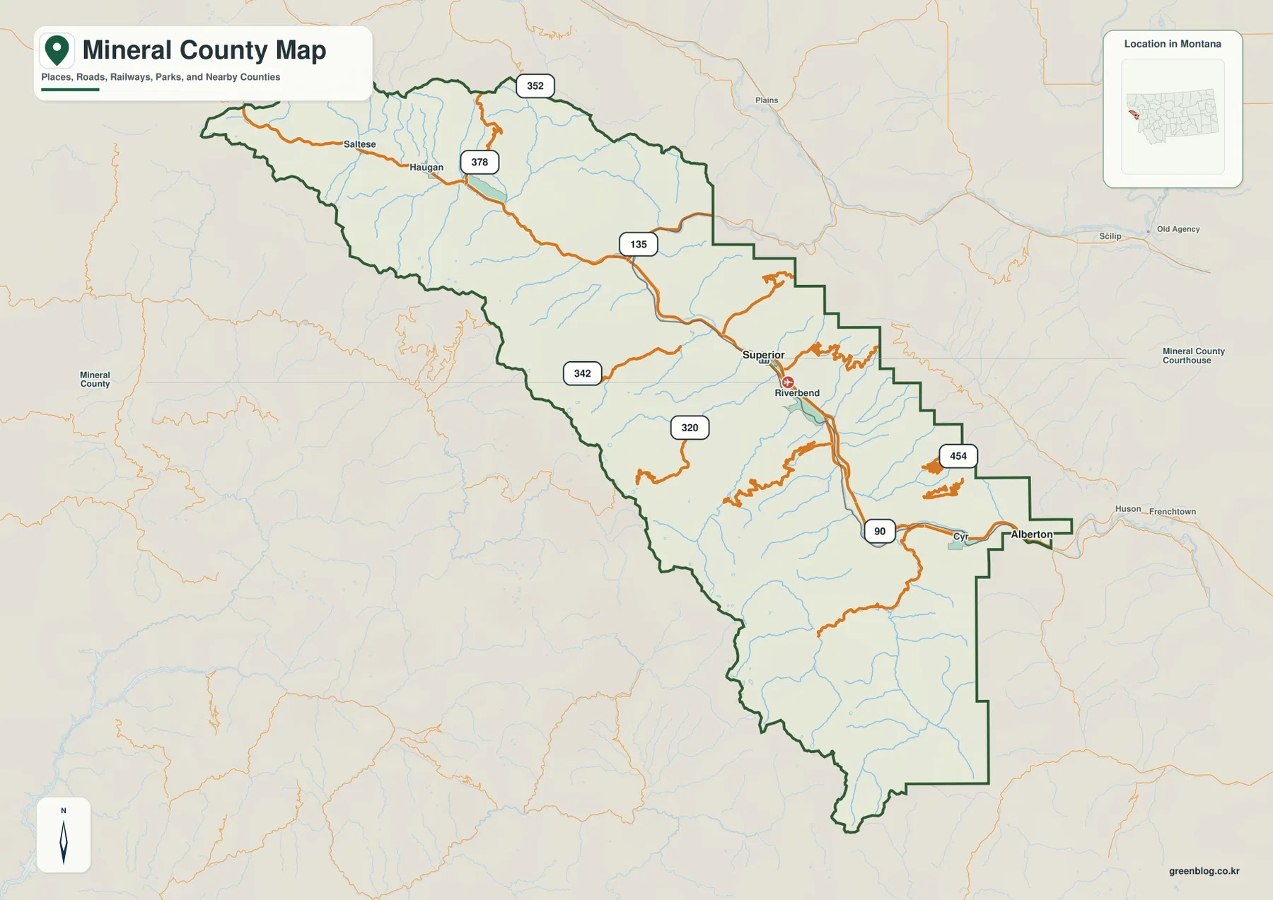
Mineral County forms a long, narrow mountain corridor along Montana’s western edge, extending from the Idaho border toward the Missoula side. Superior and Alberton provide the clearest city references in the eastern half, while Haugan and Saltese mark the western mountain corridor. Interstate 90 follows the main valley across the county, and the terrain-and-water map adds the Saint Regis River, Clark Fork River corridor, Rock Creek, Trout Creek, Fish Creek, and several mountain lakes. High-resolution JPG versions of the maps are available together in the download ZIP below.
The official Mineral County website describes the county as being in northwestern Montana, bordered by Idaho on the west, and identifies Superior as the county seat. It also highlights the St. Regis and Clark Fork rivers as major geographic features. This gives a simple way to approach the maps: begin with Superior and Alberton in the east, follow I-90 west toward Haugan and Saltese, and then use the rivers and creeks to distinguish the surrounding mountain valleys.
Table of Contents
Interstate 90 follows the main valley through Superior and Alberton
On the general county map, Superior lies near the east-central part of Mineral County and Alberton occupies the narrow eastern end. Interstate 90 provides the strongest continuous road reference, passing the Superior area before continuing toward Alberton and the Missoula side.
Riverbend appears near Superior and Cyr closer to Alberton. Moving west, Haugan and Saltese occupy a separate mountain corridor, with Route 378 near Haugan and Route 352 closer to the northwestern boundary. Route 135 forms another important connection in the central county.
Routes 320 and 342 serve mountain areas south of the main corridor, while Route 454 appears farther east. The county boundary narrows and steps repeatedly toward the east, so places that appear close on the map may still be separated by ridges and indirect roads. Current winter restrictions, construction, and remote-road conditions should be checked separately.
Superior and Alberton are the two ranked cities
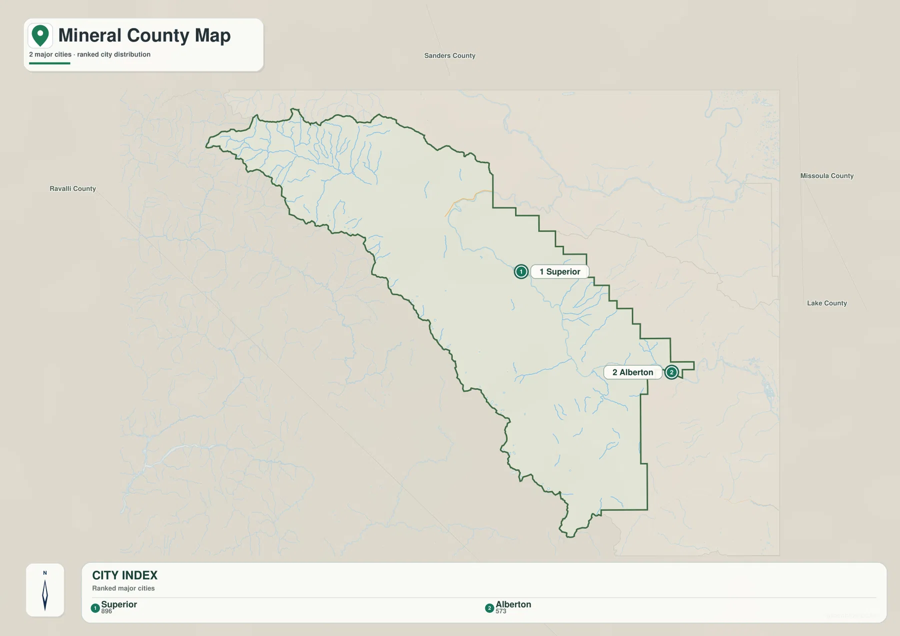
The city map ranks two places: Superior and Alberton. Its CITY INDEX lists Superior at 896 and Alberton at 573. These values are embedded in the supplied map and should not be treated as guaranteed current population estimates. Current demographic totals should be checked through recent U.S. Census Bureau data.
Superior lies in the east-central county, while Alberton sits farther east near the narrow end of the boundary. Surrounding labels include Sanders, Missoula, Lake, and Ravalli counties, helping place Mineral County within the mountain landscape of western Montana.
No connector line or mileage label is printed between Superior and Alberton. The spacing should therefore be treated only as a location reference, not as straight-line distance or road mileage. Actual travel should be checked on the general map and with current navigation information.
Saint Regis River and Clark Fork define the longest low corridors
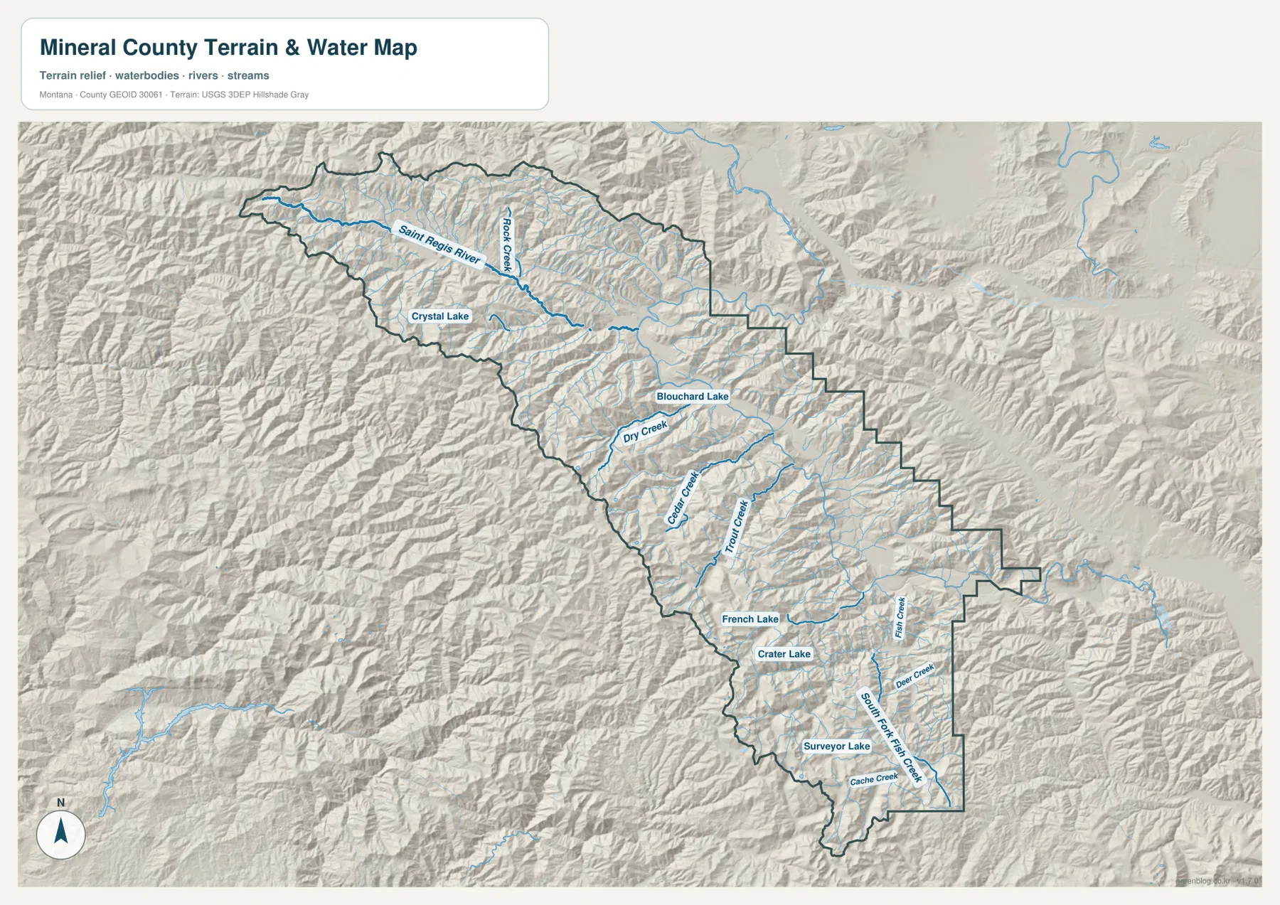
The terrain-and-water map gives Saint Regis River a dominant role across the western half. It follows a long mountain valley from the Saltese-Haugan side toward the center of the county and collects numerous short tributaries descending from high ridges.
The eastern half is closely tied to the Clark Fork River corridor. Mineral County’s official website identifies Clark Fork as one of the county’s major rivers, and the Town of Superior notes that the river flows through Superior. The broad lower valley also explains why Interstate 90 and the larger settlements occupy this part of the county.
The terrain-and-water map is intended for geographic reference. It does not establish flood zones, water depth, parcel boundaries, water rights, navigation conditions, or safe stream crossings. Current access and water conditions should be checked through the appropriate official sources.
Mountain creeks and lakes divide the interior into separate basins
Rock Creek descends through the north-central mountains, with Crystal Lake providing a nearby landmark. Blouchard Lake appears farther east, and Dry Creek occupies a separate valley to the south. These names become especially useful in areas where there are few road or settlement labels.
Cedar Creek and Trout Creek run through separate south-central valleys. French Lake and Crater Lake appear farther south, providing clear reference points among tightly packed ridges. Their positions show how the county contains many distinct mountain basins rather than one continuous upland.
Fish Creek is prominent in the southeastern section, with South Fork Fish Creek, Deer Creek, and Cache Creek nearby. Surveyor Lake provides another marker near the southern end. Comparing these water features with the elevation map shows that most occupy lower valleys between higher ridges.
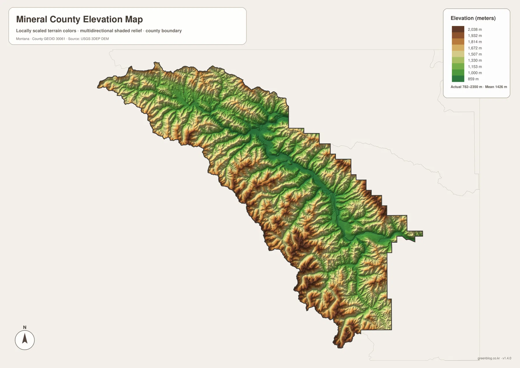
Elevation ranges from about 782 to 2,350 meters
The elevation map reports an actual county range of about 782 to 2,350 meters, with a mean elevation near 1,426 meters. The main river corridors appear in green, while yellow and brown ridges rise closely on both sides across nearly the entire county.
High terrain is especially dense in the west and northwest, where the Saint Regis River and tributaries occupy narrow lower routes. The south-central county also contains extensive high ridges divided by Trout Creek, Cedar Creek, and other valleys. Around Superior and Alberton, the main valley broadens somewhat but remains closely bordered by mountains.
The southeastern Fish Creek system creates another network of low green valleys surrounded by higher terrain. The elevation map is intended for county-wide comparison only and should not be used as survey-grade or engineering-grade data for a specific property.
Superior, Alberton, and the river corridors create a simple framework
A practical way to read Mineral County is to use Superior and Alberton as the eastern city references and Haugan and Saltese for the west. Interstate 90 provides the main travel corridor, while routes 135, 320, 342, 352, 378, and 454 help locate side valleys.
Water features provide the next layer. Saint Regis River organizes the western half, Clark Fork helps with the eastern corridor, and Rock, Dry, Cedar, Trout, and Fish creeks divide the mountain interior. Crystal, Blouchard, French, Crater, and Surveyor lakes provide additional local landmarks.
The WebP images embedded in the article are convenient for quick browsing. The high-resolution JPG files in the ZIP are better for printing or enlarging small road, river, creek, and lake labels. Because these are static reference maps, current road access, water levels, and seasonal restrictions should be checked through current official information.
Frequently Asked Questions
Does the city map show the distance between Superior and Alberton?
No. The city map ranks and locates Superior and Alberton but does not print a connector line, straight-line distance, or road mileage between them. Use the general county map and current navigation information for an actual trip.
Where is the highest terrain in Mineral County?
High terrain is widespread across the county, especially in the western, northwestern, and south-central mountain areas. The Saint Regis and Clark Fork river corridors and major creek valleys are much lower.
Can the 782–2,350 meter elevation range be used for a property or engineering project?
No. The range is a county-wide reference for comparing low river valleys with high mountain ridges. Precise site elevations should come from an authoritative source such as the USGS 3D Elevation Program and, when necessary, a professional survey.
Map File Information
Download the Mineral County county, city, terrain-and-water, and elevation maps as high-resolution A3 JPG files.
- Included Files: county map, city map, terrain and water map, elevation map
- File Type: ZIP containing 4 JPG files
Related Maps
Sources and References
County government and local background are available from the official Mineral County website, which describes the county as northwestern Montana, identifies Superior as the county seat, and highlights the St. Regis and Clark Fork rivers. The Town of Superior also notes that Clark Fork River flows through town.
Boundary and road-reference data can be checked through U.S. Census Bureau TIGER/Line Shapefiles. Hydrographic data are available from USGS National Hydrography, and elevation data through the USGS 3D Elevation Program.
Green Map creates custom-edited map images using open geographic data sources such as geoBoundaries, Natural Earth, OpenStreetMap, and government open data. These maps are edited visual materials, not raw data files, and are provided for education, documents, presentations, and graphic reference.