Glacier County stretches from the open prairie around Cut Bank to sharply rising mountain terrain along its western edge. Cut Bank is the only ranked city on the supplied city map, but the county’s geography is much broader than that single urban reference suggests. Babb and St. Mary sit closer to the mountains, Saint Mary Lake and Lake Sherburne occupy deep western valleys, and the Milk River forks spread across the lower interior. The maps on this page are also available together as high-resolution JPG files in the download ZIP below.
The county’s most useful contrast is east versus west. Roads and broad lowlands dominate the Cut Bank side, while the western margin is defined by steep ridges, large lakes, and narrow river valleys. The elevation map reinforces that change, with most of the east in green and the mountain front rising quickly into yellow and brown terrain.
Table of Contents
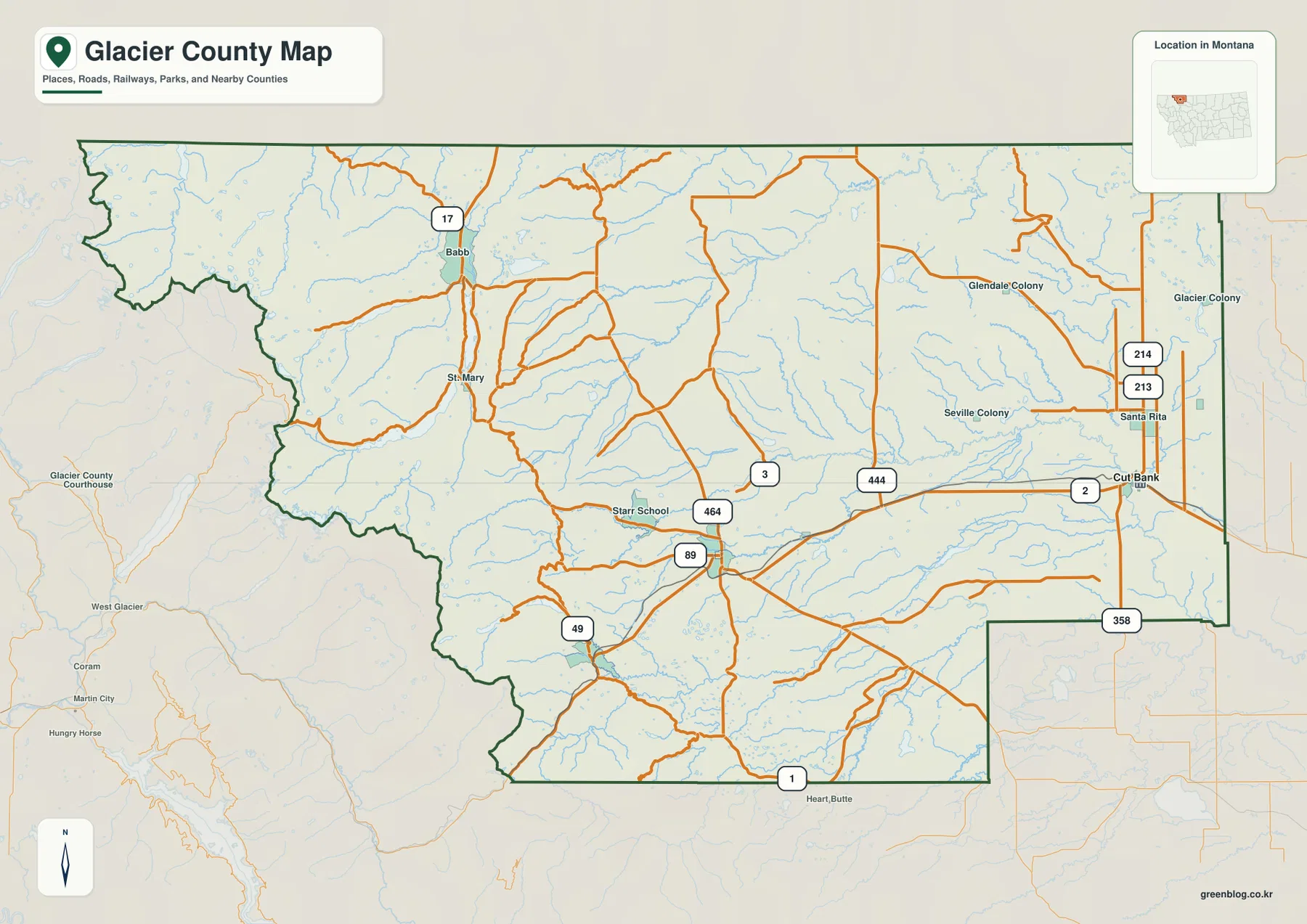
Cut Bank anchors the road network on the eastern prairie
On the general county map, Cut Bank lies close to the eastern boundary. U.S. 2 passes through the city and continues west, while routes 213 and 214 extend north near Santa Rita. Route 444 runs west of Cut Bank, and Route 358 appears farther south near the southeastern boundary.
Farther into the county, Route 89 provides a central north-south reference and Route 464 crosses part of the interior. Route 49 appears nearer the southwestern mountain side. Babb sits in the northwest near Route 17, with St. Mary farther south. Starr School and Heart Butte provide additional location references through the central and southern portions of the county.
West Glacier, Coram, and Hungry Horse appear beyond the county boundary and are useful only as outside reference points. The map shows location rather than live travel conditions, so construction, winter restrictions, and mountain-road access should be checked with current transportation information.
The ranked city map contains only Cut Bank
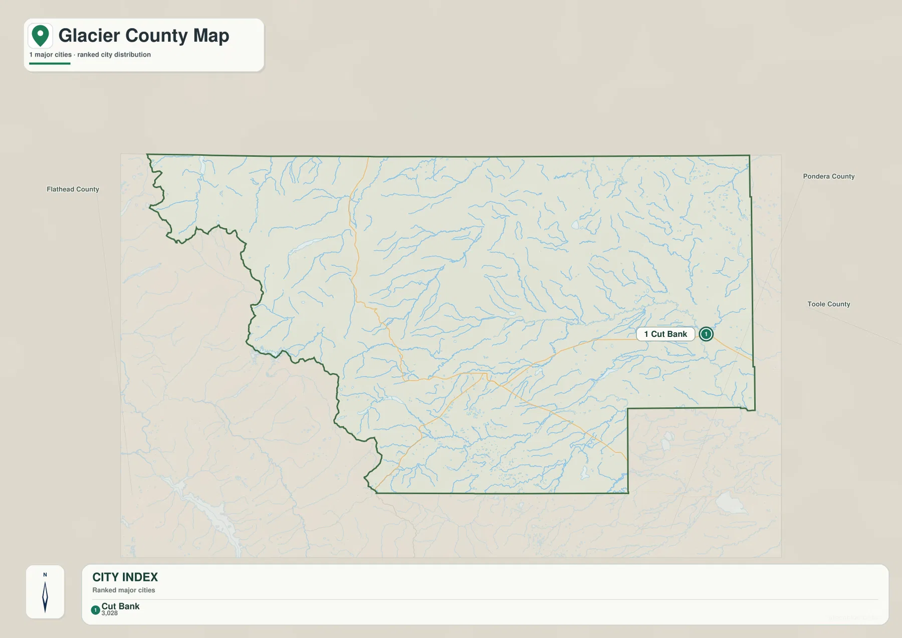
The city map shows one ranked city: Cut Bank. Its printed index lists a value of 3,028. That figure is the value embedded in the supplied map and should not be treated as a guaranteed current population estimate. Current demographic figures should be checked through recent U.S. Census Bureau data.
Cut Bank’s eastern location is important. It works well as a reference for the prairie and highway network, but it does not represent the geography of the western half, where mountain settlements, lakes, and river corridors become more useful than city names.
Because there is only one ranked city, there are no city-to-city connector lines or mileage labels on the map. Babb, St. Mary, Heart Butte, and other local labels are better located on the general county map rather than through the city ranking view.
Saint Mary Lake and Lake Sherburne define the western mountain valleys
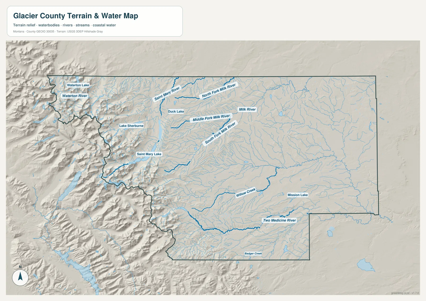
The terrain-and-water map becomes much more dramatic on the western side. Saint Mary Lake stretches through a deep mountain valley, with Lake Sherburne farther north. Near the northwestern edge, Waterton Lake and Waterton River appear among steep terrain cut by narrow valleys.
Saint Mary River flows eastward from the mountain side and passes near Duck Lake. Farther north and east, North Fork Milk River leaves the higher country and enters the broader prairie. Middle Fork Milk River and South Fork Milk River provide parallel references across the central-northern interior before the drainage continues toward the Milk River.
These waterways are useful geographic references, but the map is not a flood-hazard product, navigation chart, parcel map, water-rights record, or guide to safe crossings. Water access and current conditions should be checked through the appropriate agencies.
Milk River forks and Two Medicine River cross the lower interior
East of the mountain front, the drainage pattern opens into broader, gentler valleys. North Fork, Middle Fork, and South Fork Milk River cross the northern and central interior, with the Milk River itself labeled farther east. Their valleys are much wider than the tightly confined lake and river corridors near the western mountains.
Two Medicine River is one of the strongest water references in the southern county. Willow Creek runs through the central-south, Mission Lake lies farther east, and Badger Creek follows a long route near the southern boundary. These waterways help organize a large rural area where city labels are sparse.
Duck Lake occupies a useful position between the Saint Mary system and the Milk River forks. Unlike the long western mountain lakes, it lies near more open terrain, making it a good marker for the transition from rugged mountain relief to the broader interior prairie.
Elevation rises from about 994 meters to 3,164 meters
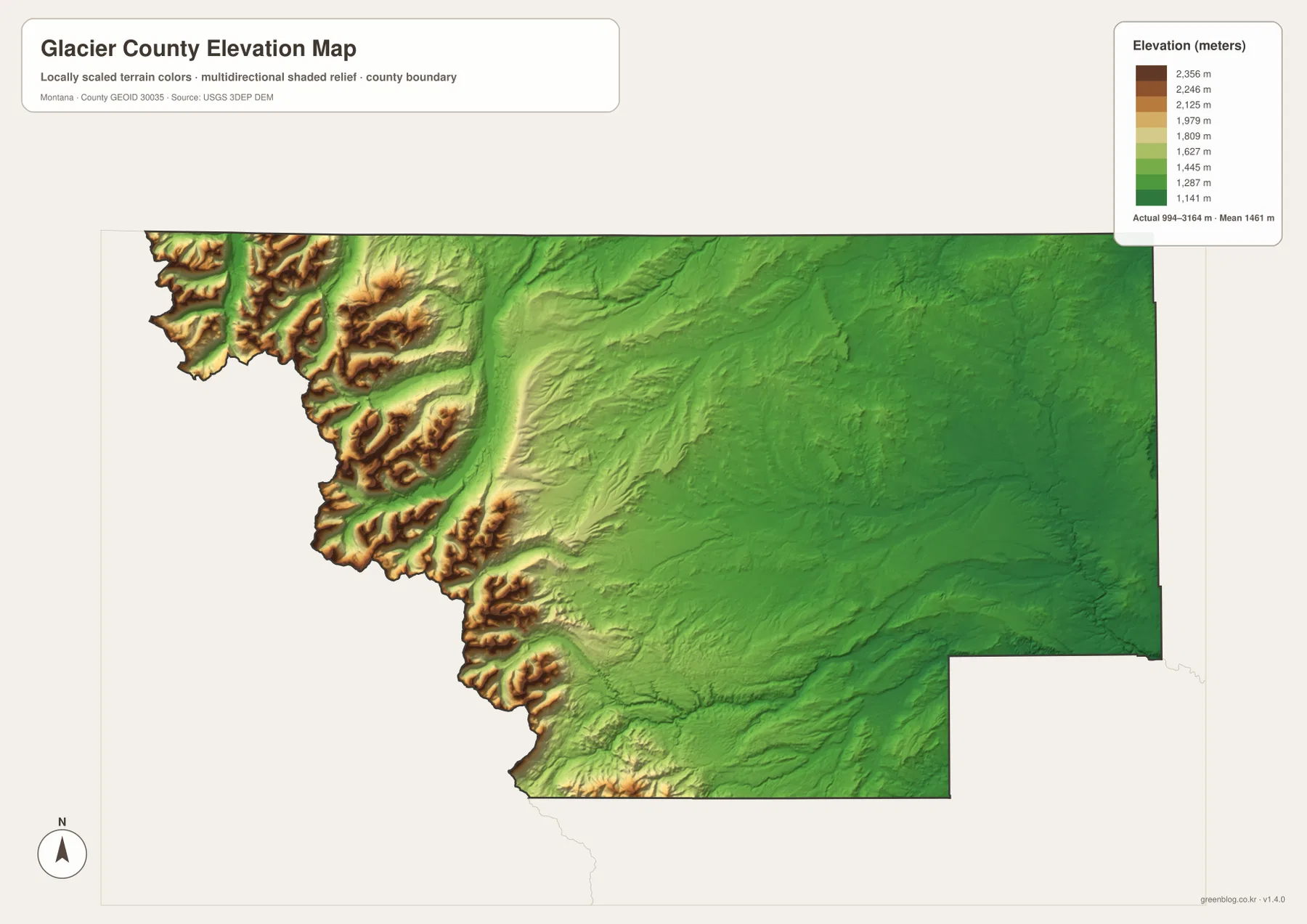
The elevation map reports an actual county range of about 994 to 3,164 meters, with a mean elevation near 1,461 meters. Most of the eastern half appears in green, indicating lower and gentler terrain. Along the western boundary, the colors change abruptly through yellow and brown as the Rocky Mountain front rises to the county’s highest terrain.
The area west of Babb and St. Mary contains tightly packed ridges and deep valleys. Saint Mary Lake and Lake Sherburne sit within that high mountain environment, while terrain becomes progressively lower and smoother moving east toward Cut Bank. The southern mountain edge shows a similar pattern around the Heart Butte side.
Saint Mary River, the Milk River forks, and Two Medicine River remain visible as lower corridors within the elevation surface. Comparing the water and elevation maps makes the west-to-east descent especially clear. The elevation map is intended for county-wide comparison and should not be used as survey-grade or engineering-grade data for a specific property.
Reading the county from prairie to mountain front keeps the map coherent
A practical way to use the map set is to begin at Cut Bank and move west. U.S. 2, routes 213 and 214, and the lower Milk River drainage organize the eastern prairie. Route 89, Route 49, and the Babb-St. Mary area then mark the transition into more rugged terrain.
The county’s water features reinforce the same pattern. The Milk River forks and Two Medicine River cross the lower interior, while Saint Mary Lake, Lake Sherburne, and Waterton Lake sit much closer to the high mountain edge. Heart Butte and Badger Creek provide additional references in the south.
The WebP images embedded in the article are convenient for quick viewing. The high-resolution JPG files in the ZIP are better for printing or enlarging smaller road, river, and lake labels. Since these are static reference maps, current road access, water conditions, and seasonal restrictions should be checked through current official sources.
Frequently Asked Questions
Why does the Glacier County city map show only Cut Bank?
The supplied city map ranks major places, and Cut Bank is the only city shown. Because there is only one ranked city, the map does not include city-to-city connector lines or mileage labels. Babb and St. Mary are better located on the general county map.
Where is the highest terrain in Glacier County?
The highest terrain is concentrated along the western mountain edge, especially west of Babb and St. Mary around the Saint Mary Lake and Lake Sherburne valleys. The Cut Bank side of the county is much lower and flatter.
Can the 994–3,164 meter elevation range be used for a property or engineering project?
No. The range is a county-wide reference for comparing the eastern prairie with the western mountains. Precise site elevations should come from an authoritative source such as the USGS 3D Elevation Program and, when necessary, a professional survey.
Map File Information
Download the Glacier County county, city, terrain-and-water, and elevation maps as high-resolution A3 JPG files.
- Included Files: county map, city map, terrain and water map, elevation map
- File Type: ZIP containing 4 JPG files
Related Maps
Sources and References
Local government information for Cut Bank is available from the official City of Cut Bank website. Montana DPHHS also lists the Glacier County office in Cut Bank.
Boundary and road-reference data can be checked through U.S. Census Bureau TIGER/Line Shapefiles. Hydrographic data are available from USGS National Hydrography, and elevation data through the USGS 3D Elevation Program.
Green Map creates custom-edited map images using open geographic data sources such as geoBoundaries, Natural Earth, OpenStreetMap, and government open data. These maps are edited visual materials, not raw data files, and are provided for education, documents, presentations, and graphic reference.