Chase County lies in southwestern Nebraska, with Imperial near the center, Wauneta in the southeast, and Lamar to the west. The Frenchman River crosses the lower middle of the county and passes through Enders Reservoir, while the land rises toward the west and southwest. The result is a broad High Plains landscape in which the main towns, roads, river valley, and elevation change are easy to connect on the supplied maps. High-resolution map files are available for download in the section below.
This page explains the county boundary and road network, straight-line city connections from Imperial, the Frenchman River and Enders Reservoir system, and an elevation range of about 888 to 1,138 meters. The original high-resolution JPG versions of the supplied maps are also available together in a ZIP for printing, classroom use, or personal reference.
Table of Contents
Imperial provides the clearest reference for a wide east-west county
Imperial is the Chase County seat and the strongest geographic reference on the map. The official county website says the county boundaries were established in 1873 and organization began in 1886. Today the county offices are based in Imperial, which lies close to the center and provides a convenient starting point for locating Wauneta, Lamar, Enders, and the Frenchman River corridor.
Perkins County lies to the north, Hayes and Hitchcock Counties are east, and Dundy County borders the west. The southern edge is part of Nebraska’s high southwestern plains near Colorado. The outer boundary is comparatively simple, but the terrain inside it slopes strongly enough from west to east to create obvious differences between upland farms and creek valleys.
History Nebraska records that Chase County was organized by a governor’s proclamation on April 12, 1886, after previously being attached to Hayes County for judicial and legal purposes. The county was named for Champion S. Chase, Nebraska’s first attorney general. The county’s own history says several towns competed for the county seat before Imperial ultimately secured that role.
U.S. 6 ties Imperial, Enders, and Wauneta to the Frenchman corridor
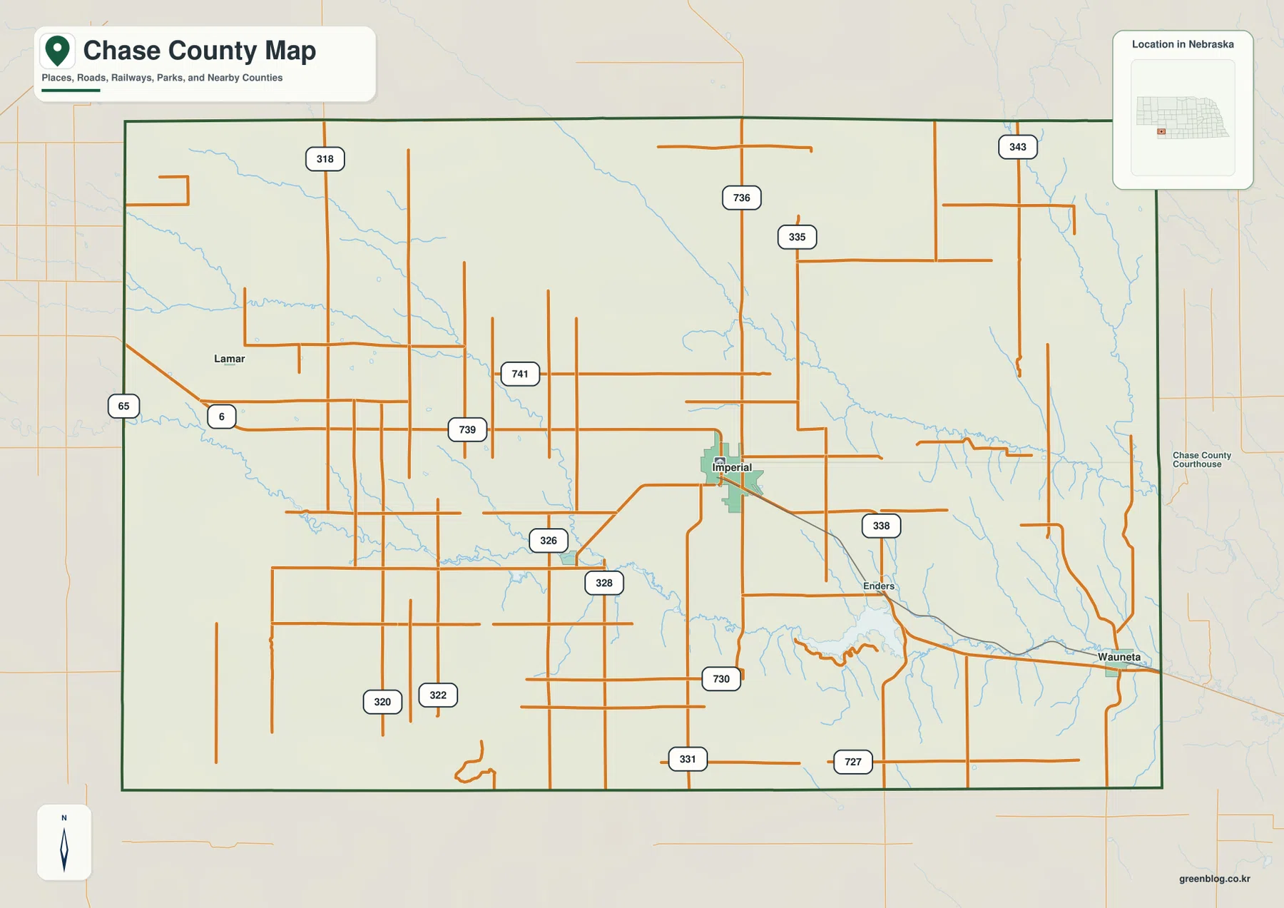
The simplest transportation line to follow is the east-west route connecting Imperial with Enders and Wauneta. U.S. 6 serves the southern half of the county and keeps the three principal locations in one broad corridor. Enders sits between Imperial and Wauneta close to the Frenchman River and reservoir, making the road and water geography easy to compare.
Imperial also has numerous county roads extending north and south into the surrounding agricultural land. Lamar lies to the west on the higher side of the county and is much smaller on the map. East of Imperial, roads increasingly approach the Frenchman River and its tributary valleys before reaching Wauneta near the county line.
Large parts of northern and southern Chase County are served by long numbered rural roads with widely spaced junctions. Those open stretches mean two points that look close on a small map may require a longer practical drive. The general map is useful for orientation, but construction, closures, surface conditions, and travel time should be checked with current transportation information.
Wauneta is 15 straight-line miles from Imperial, Lamar 18
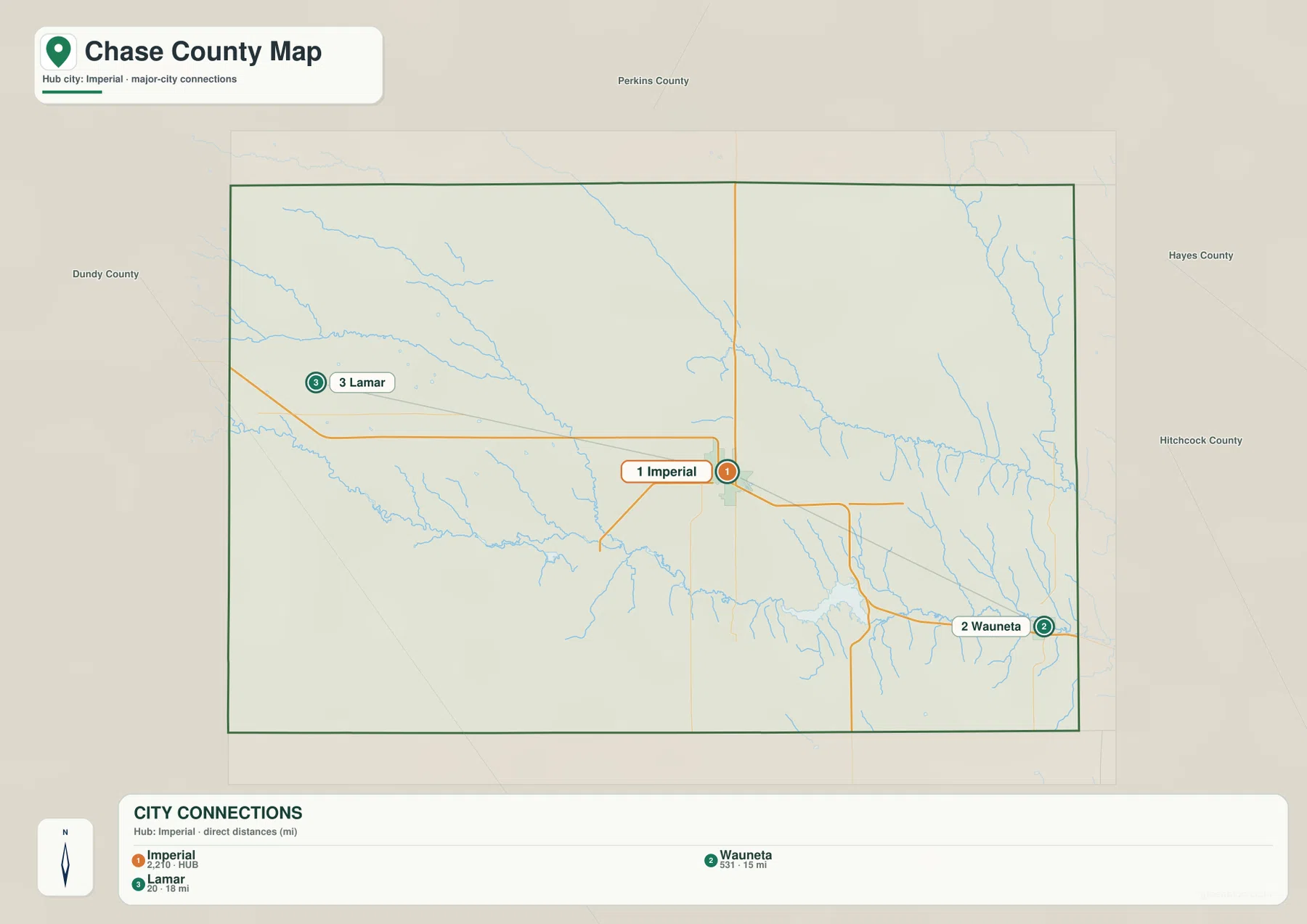
The city-connection map uses Imperial as the hub. It shows approximately 15 straight-line miles from Imperial to Wauneta and 18 miles from Imperial to Lamar. These are direct point-to-point measurements rather than road mileage, so actual driving distances depend on the route and the exact starting and ending locations.
Wauneta lies southeast of Imperial close to the Frenchman River valley, while Lamar is west of the county seat on higher ground. That contrast makes the city map more useful than a simple population ranking: the three markers also represent different parts of the county’s relief and drainage pattern.
The ranked values printed on the supplied map are 2,210 for Imperial, 531 for Wauneta, and 20 for Lamar. These figures are part of the map’s city comparison and should not be treated as a complete or continuously updated county population table. Current demographic figures should be checked with the U.S. Census Bureau or another authoritative source.
Frenchman River and Enders Reservoir define the main water corridor
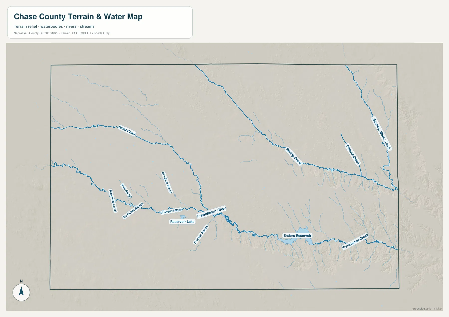
The Frenchman River is the county’s defining watercourse. It enters from the west, crosses the lower-middle part of Chase County, passes through Enders Reservoir, and continues east toward Wauneta. History Nebraska specifically identifies the Frenchman as the county’s principal watercourse.
Enders Reservoir lies between Imperial and Wauneta. Nebraska Game and Parks manages the surrounding State Recreation Area and says the reservoir and associated recreation and wildlife lands cover about 5,700 acres in total. On the map, the Frenchman enters the reservoir from the west and exits on the eastern side before continuing downstream.
Sand Creek is prominent in the northwest, while Spring Creek cuts across the northeastern interior. Bronco Creek and other smaller tributaries descend toward the eastern drainage. Reservoir Lake and Champion Canal appear around the upper Frenchman system, showing that both natural waterways and managed irrigation features are part of the county’s mapped water network.
This water map is intended for geographic reference only. It does not establish flood risk, legal water rights, parcel boundaries, reservoir levels, channel depth, or navigability. Current conditions and regulatory questions require information from USGS, Nebraska Game and Parks, and the responsible water-management agencies.
Elevation falls from western high ground into the Frenchman valley
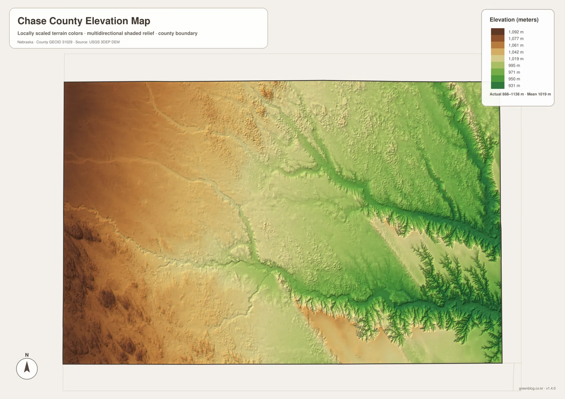
The elevation map reports an actual county-wide range of about 888 to 1,138 meters, with a mean near 1,019 meters. Brown and tan colors dominate the west and southwest, while greens become more common toward the east. The roughly 250-meter difference is spread across a broad plain rather than concentrated in one mountain front.
The Frenchman River forms a long low corridor through the lower-middle part of the county. Enders Reservoir and the downstream route toward Wauneta occupy some of the clearest green terrain. Numerous short tributaries descend from the surrounding uplands, giving the eastern half a more strongly dissected appearance than a road-only map suggests.
The western side includes broad uplands broken by shallow valleys, and the southwest contains some of the highest ground in Chase County. Imperial lies closer to the transition between the higher west and the lower Frenchman system, while Wauneta sits nearer the deeply cut river valley farther east.
The colors are scaled locally for Chase County and are intended for relative comparison within this map. Similar shades on another county map may represent different absolute elevations. The generalized surface is not survey-grade information for engineering, construction, drainage design, or property work.
Enders Reservoir links the river map with a major recreation area
Enders Reservoir is more than a labeled water body. Nebraska Game and Parks lists boating, camping, fishing, kayaking and canoeing, picnicking, swimming, and hunting among the recreation opportunities at Enders Reservoir State Recreation Area. Part of the surrounding property is managed as a wildlife refuge, so seasonal access and use rules can differ by area.
Its location also makes geographic sense on the county map. The reservoir occupies the Frenchman River valley between Imperial and Wauneta and sits close to the main east-west transportation corridor. For visitors, that makes Enders one of the best places to connect Chase County’s road, water, and relief maps in a single real-world setting.
Imperial’s county-seat role grew with transportation and settlement
The official county history says the boundaries were established in 1873 and county organization began in 1886. Several communities competed for the county-seat role, and Imperial eventually became the administrative center. History Nebraska also records that the Burlington Railroad reached Imperial in 1892 but was not extended beyond the town.
The modern map still reflects Imperial’s central position. Roads extend in several directions from the city, while Wauneta and Lamar remain smaller communities on opposite sides of the county. The Frenchman River, agricultural land, and historical transportation routes all helped shape a settlement pattern in which Imperial became the main service and government center.
Use Imperial and the Frenchman River as the two main map anchors
For basic orientation, locate Imperial first and follow U.S. 6 east toward Enders and Wauneta or west toward Lamar. The city map simplifies the same relationship with two straight-line distance labels, making the county’s east-west scale easy to understand.
For physical geography, begin with the Frenchman River and Enders Reservoir, then trace Sand Creek and Spring Creek across the north. The elevation map explains why the river corridor sits lower than the western uplands and why so many smaller streams descend toward the east.
For printing or classroom display, the downloadable high-resolution JPG files preserve more road labels and stream names than the web previews. The county map emphasizes roads and boundaries, the city map shows Imperial-centered direct distances, the water map highlights the Frenchman system and reservoir, and the elevation map shows the west-to-east change in relief.
Frequently Asked Questions
Are the 15- and 18-mile city distances driving distances?
No. The city map shows straight-line distances of about 15 miles from Imperial to Wauneta and 18 miles from Imperial to Lamar. Actual driving mileage depends on the roads used and the exact starting and ending points.
Where is the lowest terrain in Chase County?
The Frenchman River valley, Enders Reservoir area, and the eastern route toward Wauneta contain the lowest broad terrain. The county-wide elevation range is about 888 to 1,138 meters, with higher ground becoming more common toward the west and southwest.
Can the Enders Reservoir map be used for current water level or flood decisions?
No. It is a geographic reference showing the Frenchman River, Enders Reservoir, Spring Creek, and other waterways. Current reservoir level, flood risk, water rights, property boundaries, and access conditions require current authoritative records.
Map File Information
The ZIP contains the original high-resolution JPG files for the Chase County boundary and road map, city-connection map, terrain and water map, and elevation map.
- Included Files: Use only the versions confirmed in the article and supplied images
- File Type: Use the confirmed download contents
- Intended Use: Printing, education, presentations, and map-based projects
Related Maps
Sources and references
- Chase County official website
- History Nebraska – Chase County Historical Note
- Nebraska Game and Parks – Enders Reservoir State Recreation Area
- U.S. Census Bureau TIGER/Line Shapefiles
- USGS National Hydrography
- USGS 3D Elevation Program
These maps are intended for geographic reference. For legal boundaries, land ownership, flood determinations, water rights, road conditions, construction, surveying, or other decisions requiring current authoritative information, consult Chase County and the responsible state or federal agency.
Green Map creates custom-edited map images using open geographic data sources such as geoBoundaries, Natural Earth, OpenStreetMap, and government open data. These maps are edited visual materials, not raw data files, and are provided for education, documents, presentations, and graphic reference.