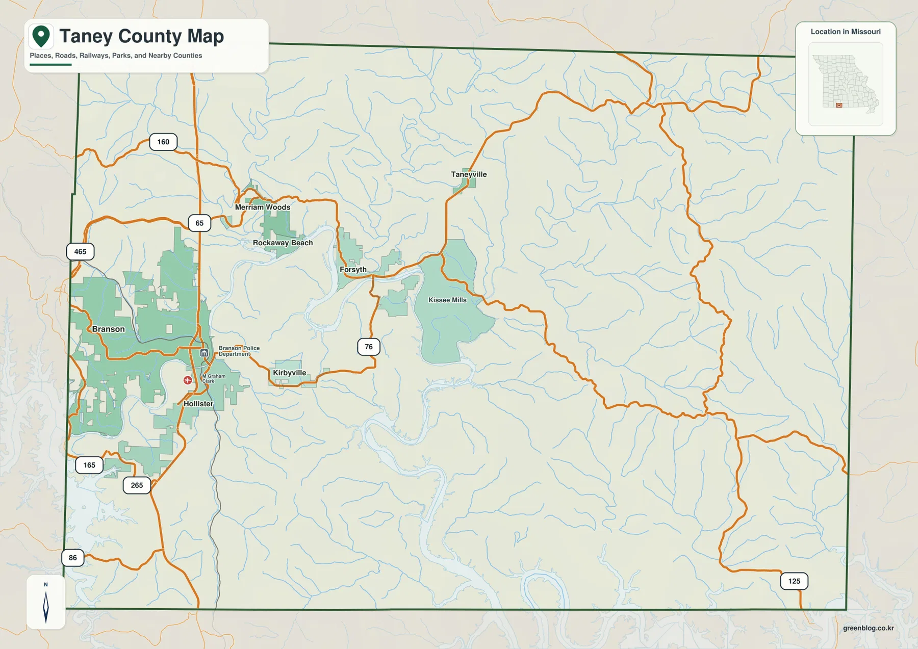
Taney County lies in the southern Missouri Ozarks, where the Branson tourism corridor meets deep lake and river valleys and a much larger expanse of rugged uplands. Branson is the largest highlighted city, while Forsyth, Hollister, Merriam Woods, Rockaway Beach, and Bull Creek provide additional references around Lake Taneycomo and the western road network. U.S. 65 is the clearest north-south route, and Route 76 links Branson with the Forsyth side. High-resolution map files are available for download in the section below.
This page separates those features into a general county map, a ranked city map, a terrain-and-water map, and an elevation map showing roughly 201 to 449 meters of relief. High-resolution JPG originals of all four can be downloaded together in one ZIP for enlargement, A3 printing, classroom materials, reports, or personal reference.
Table of Contents
Branson, Forsyth, and the U.S. 65–Route 76 road framework
Branson is the easiest place to begin reading the general map. It occupies the largest urban footprint near the western side of the county, with U.S. 65 crossing the area north to south. Hollister lies immediately south of Branson, so the two communities form a strong road and settlement reference.
Forsyth lies farther east near Lake Taneycomo. The official Taney County website lists the courthouse at 132 David Street in Forsyth, confirming the town’s county-seat role. Route 76 provides the clearest connection between the Branson side and the Forsyth area across the central-western county.
Merriam Woods and Rockaway Beach lie northwest of Forsyth, while Bull Creek sits farther west. U.S. 160 and the Route 65 corridor help organize the northwestern side, and Route 465 provides another major road reference north and west of Branson. This part of the county contains far more settlement labels than the sparsely populated eastern uplands.
Routes 165 and 265 serve the Branson–Hollister side, Route 86 crosses the far southwest near the Arkansas border, and Route 125 extends through the east. The eastern half has fewer large communities and many winding roads shaped by the terrain, so using the major numbered routes first is the easiest way to maintain orientation.
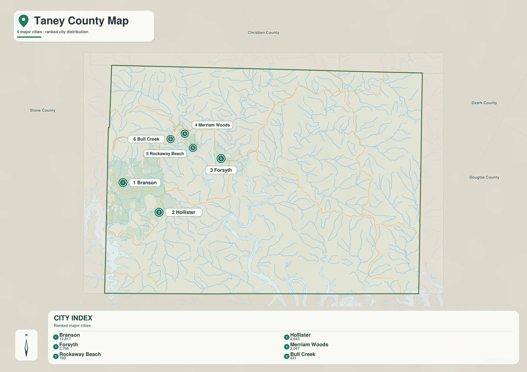
Branson leads six communities clustered around the western lake corridor
The city map highlights Branson, Forsyth, Hollister, Merriam Woods, Rockaway Beach, and Bull Creek. The map index labels Branson with 12,817, Forsyth with 2,766, Hollister with 2,463, Merriam Woods with 2,047, Rockaway Beach with 760, and Bull Creek with 421. Branson is much larger than the other highlighted communities.
Branson lies in the west and Hollister directly to the south. Forsyth is farther east near Lake Taneycomo, while Merriam Woods and Rockaway Beach lie to its northwest. Bull Creek marks the western side near the Stone County boundary. Most of the six highlighted communities therefore cluster in the western half of Taney County.
Branson provides the strongest urban and tourism reference, but Forsyth is the county seat. Hollister is useful for the U.S. 65 corridor south of Branson, while Rockaway Beach and Merriam Woods help locate the northern Lake Taneycomo area. The difference between the dense western settlement pattern and the sparsely settled east is one of the clearest features on the city map.
The general map also labels Kirbyville, Taneyville, Kissee Mills, and additional smaller places that are not part of the six-city index. The ranked city map is therefore best used for quick orientation, with the general map supplying the finer road and settlement detail.
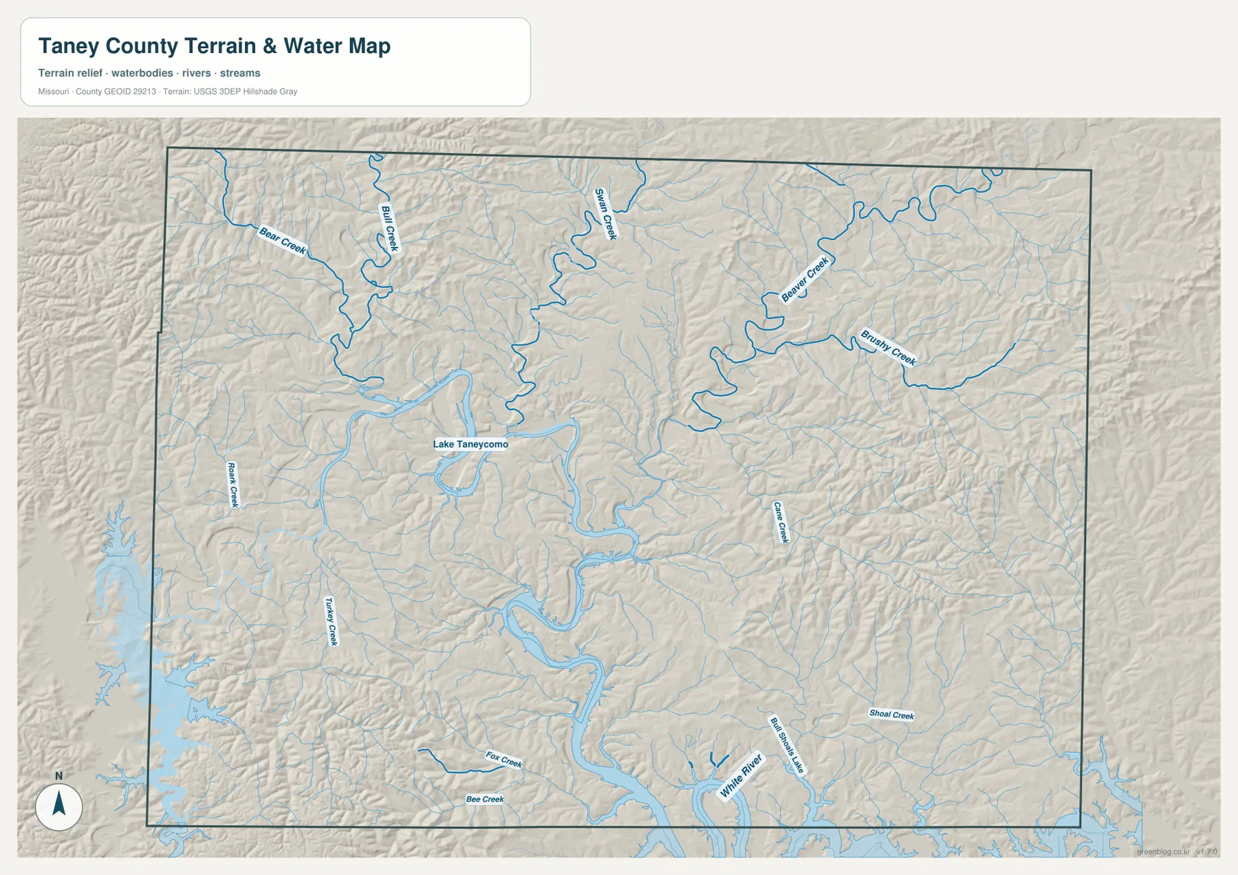
Lake Taneycomo and the White River occupy the county’s deepest corridors
Lake Taneycomo is the strongest water feature through the central-western county. Its long, narrow, winding surface follows a deeply cut valley near Branson, Hollister, Rockaway Beach, and Forsyth. Taney County’s official history notes that Table Rock, Taneycomo, and Bull Shoals are major lakes formed along the White River system.
The White River continues through the southern county, while Table Rock Lake lies along the southwestern side of the broader drainage system. The U.S. Army Corps of Engineers describes Table Rock Lake as a White River reservoir extending through Missouri and Arkansas. The reservoir’s narrow arms and the river’s repeated bends create a complex lowland network surrounded by steep Ozark slopes.
Bull Creek and Swan Creek descend from the north, while Beaver Creek and Brushy Creek divide the northeastern uplands. Bear Creek and Rock Creek provide western references, and Turkey Creek, Fall Creek, and Bee Creek cross the southwest. Shoal Creek and smaller tributaries continue through the southeast toward the White River and Bull Shoals system.
The terrain-and-water map is intended for geographic reference rather than current lake level, flood status, navigation, boating conditions, parcel boundaries, or legal water boundaries. Conditions on Table Rock Lake, Lake Taneycomo, and the White River system can change, so present-day water or recreation decisions should rely on current official information.
Elevation ranges from about 201 to 449 meters
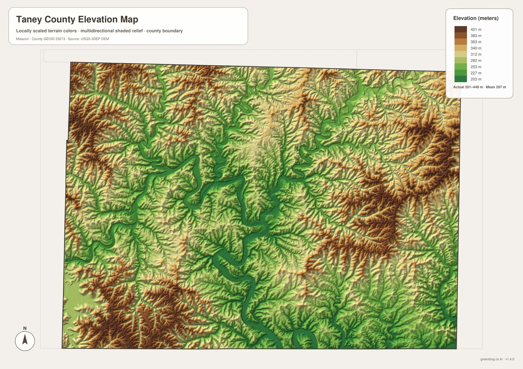
The elevation map reports an actual range of roughly 201 to 449 meters and a mean near 297 meters. Higher brown terrain is widespread in the west and northwest and again across the east and southeast. Some ridges rise well above 400 meters, producing a large vertical difference from the lake and river valleys.
The lowest green terrain follows Lake Taneycomo and the White River in a long, winding path through the county. Where the waterway makes broad bends, the low corridor widens and smaller tributary valleys join from the north and east. Forsyth and Rockaway Beach sit close to this lake-cut low ground.
The Branson and Merriam Woods side remains hilly despite its greater urban development. Farther east and southeast, settlement becomes sparse while ridges and short valleys become even more dominant. The elevation map makes it clear why roads in the eastern half are often winding rather than straight.
This county-scale elevation surface is useful for broad relief comparison, not for engineering, construction, drainage design, parcel-level elevation decisions, or survey-grade measurement. Site-specific work requires more detailed official elevation data or field surveying.
Compare the Branson road network with lake valleys and Ozark ridges
Start with Branson and U.S. 65 when roads and settlement locations matter most. Hollister lies just south, Forsyth farther east, and Merriam Woods and Rockaway Beach to the northwest. Route 76 then provides the main east-west reference, while Routes 160, 165, 265, 86, and 125 help organize the outer parts of the county.
For terrain, begin with Lake Taneycomo and the White River, then compare Bull Creek, Swan Creek, Beaver Creek, and the smaller tributaries. Switching to the elevation map shows that the named waterways occupy lower green corridors while high Ozark ridges remain tightly packed on both sides.
Taney County is widely associated with Branson, but the maps show that the urban and tourism corridor occupies only part of a much larger rugged landscape. The eastern and southern county contains extensive uplands, and Lake Taneycomo and the White River cut a deep central route through them. Using the road, water, and elevation views together makes that contrast much easier to understand.
The downloadable JPG originals contain more pixels than the WebP previews embedded on the page, making them better for enlargement, A3 printing, classroom handouts, reports, and personal reference. They remain general-purpose maps, however. Legal boundaries, live road restrictions, current water conditions, and precise site elevations should always be checked against current official sources.
Frequently Asked Questions
Where is the Taney County courthouse located?
The official Taney County website lists the courthouse at 132 David Street in Forsyth. On the map, Forsyth sits near Lake Taneycomo east of the Branson urban corridor.
How much elevation change is shown across Taney County?
The elevation map shows an actual range of about 201 to 449 meters with a mean near 297 meters. Lake Taneycomo and White River valleys are low, while western, eastern, and southeastern Ozark ridges rise much higher.
Which waterways are the best starting points on the terrain map?
Start with Lake Taneycomo through the central-western county and the White River farther south. Bull Creek, Swan Creek, and Beaver Creek provide strong additional references for the northern uplands.
Map File Information
The download ZIP contains high-resolution JPG versions of the Taney County general map, city map, terrain-and-water map, and elevation map.
- File Type: JPG
Related Maps
Sources and References
Boundary and road reference data are supported by U.S. Census Bureau TIGER/Line, water features by USGS National Hydrography, and elevation data by the USGS 3D Elevation Program. County government and courthouse information is available from the official Taney County website, and Table Rock Lake information from the U.S. Army Corps of Engineers.
Green Map creates custom-edited map images using open geographic data sources such as geoBoundaries, Natural Earth, OpenStreetMap, and government open data. These maps are edited visual materials, not raw data files, and are provided for education, documents, presentations, and graphic reference.