Saline County occupies a broad section of central Missouri between the Missouri River lowlands and the Blackwater River drainage. Marshall is the dominant city near the center-south, while Slater and Gilliam lie to the northeast, Sweet Springs to the southwest, and Blackburn and Malta Bend to the west. Roads cross a landscape of rolling interior hills, but both the northern-eastern Missouri River edge and the southern Blackwater valley drop into noticeably lower terrain. High-resolution map files are available for download in the section below.
This page separates those features into a general county map, a ranked city map, a terrain-and-water map, and an elevation map. High-resolution JPG originals of all four are available together in one ZIP for closer viewing, A3 printing, classroom work, reports, or other large-format reference use.
Table of Contents
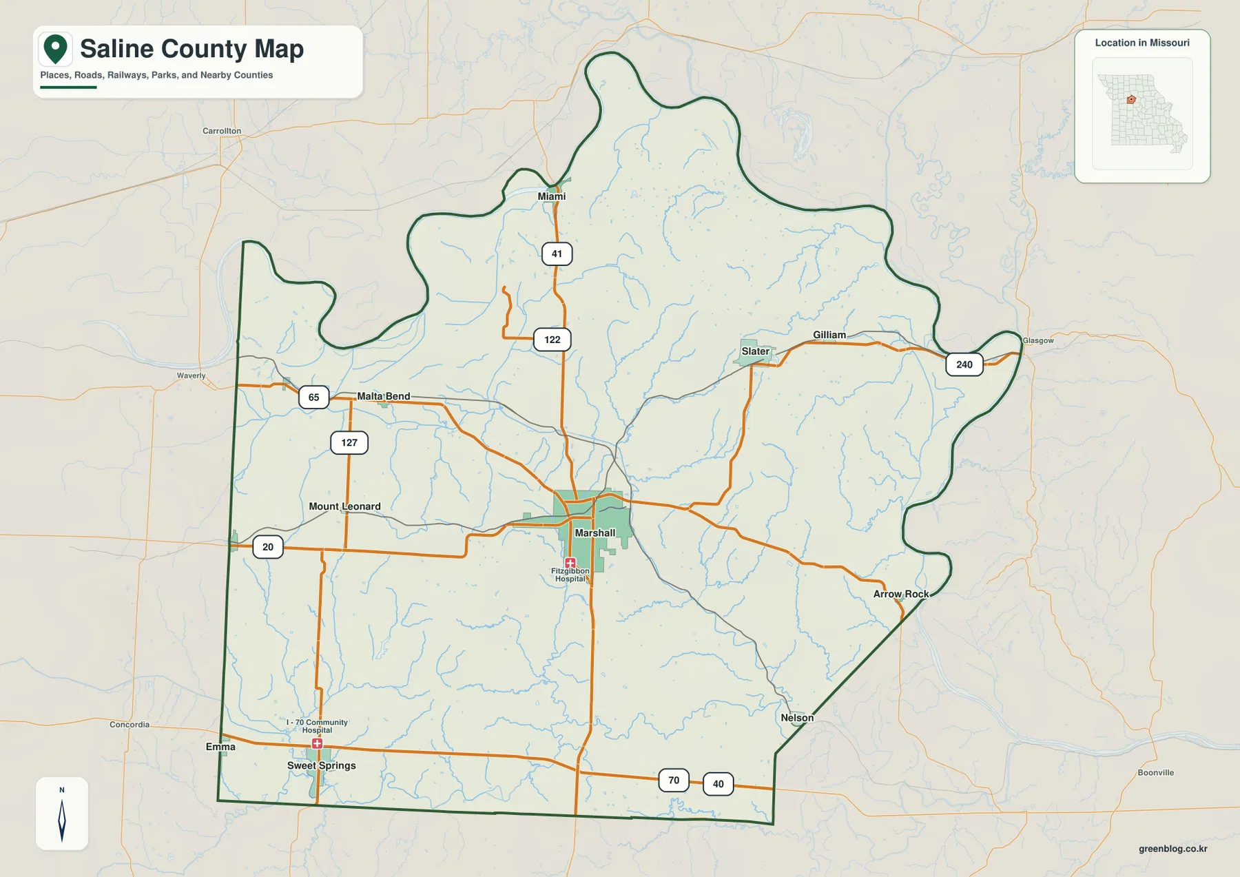
Marshall connects the county’s central road network
Marshall is the easiest place to begin reading the general map. It has by far the largest urban footprint inside the county, and Routes 20 and 41 provide strong east-west and north-south references through the surrounding countryside. Fitzgibbon Hospital is also labeled near the city, making Marshall easy to distinguish from the smaller rural communities.
Route 41 continues north toward Miami, while Route 20 extends west through the Mount Leonard side and east toward Arrow Rock. The northeastern road system changes again near Slater and Gilliam, where Route 240 follows the side of the county closer to the Missouri River. These roads provide a simple framework before smaller local routes are considered.
U.S. 65 crosses the western side near Malta Bend, and Route 127 forms another north-south reference nearby. Blackburn lies farther south along the western edge. The neighboring places shown beyond the boundary, including Waverly and Carrollton, help separate Saline County from surrounding counties on the regional map.
Sweet Springs sits in the southwest close to Interstate 70 and U.S. 40, where the road pattern looks different from the quieter central farm roads. Emma is also labeled near the western side, and the I-70 Community Hospital marker provides another recognizable southern landmark. The mix of interstate, U.S. highway, state routes, and local roads gives each part of the county a different map appearance.
Marshall stands well above five smaller highlighted communities
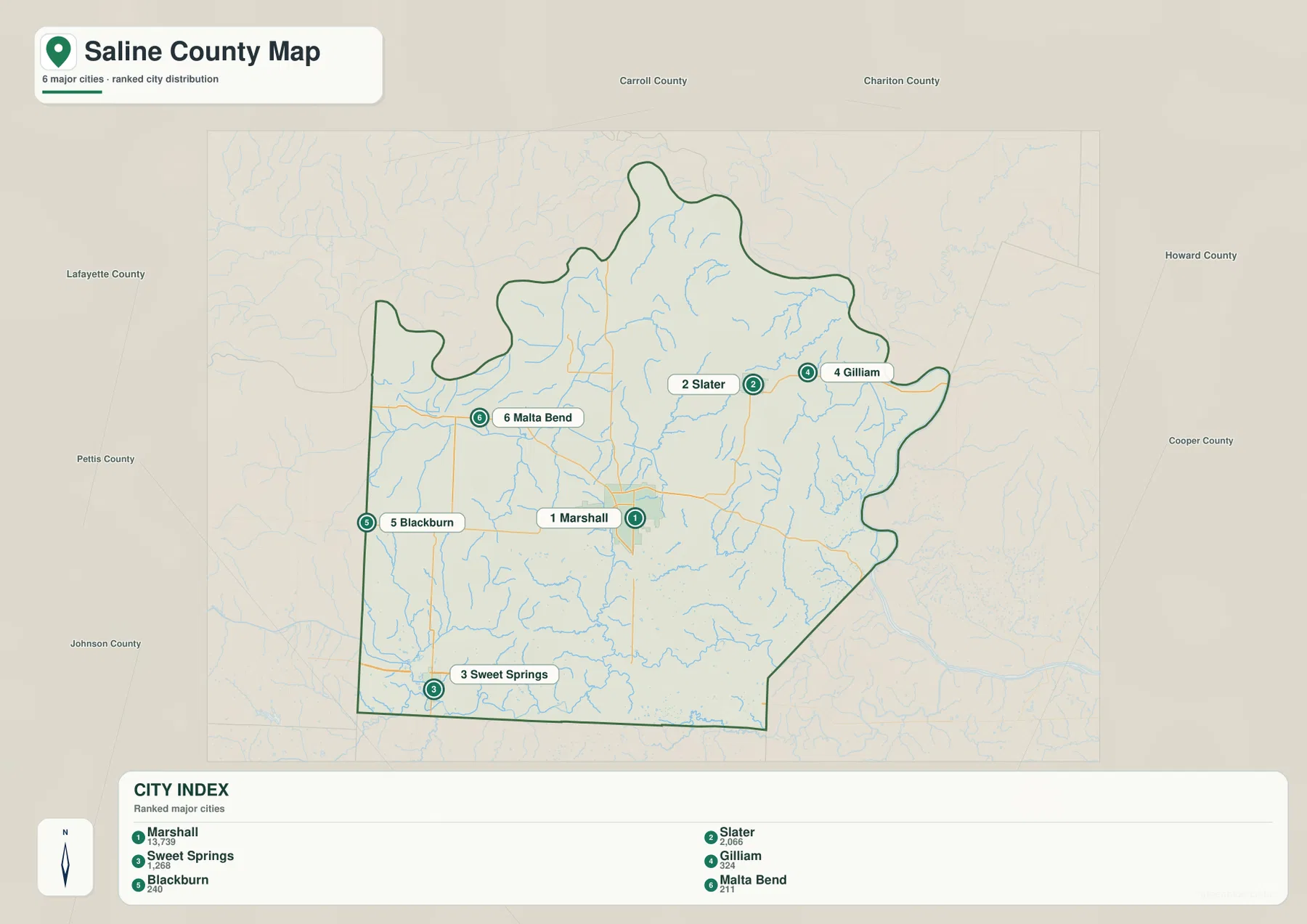
The city map highlights Marshall, Slater, Sweet Springs, Gilliam, Blackburn, and Malta Bend. Marshall is labeled with 13,739, followed by Slater at 2,066 and Sweet Springs at 1,268. Gilliam is shown with 324, Blackburn with 240, and Malta Bend with 211, making the scale difference between the main city and the smaller communities immediately visible.
Marshall occupies the central-southern interior, while Slater and Gilliam sit close together in the northeast. Sweet Springs is near the southwestern corner, Blackburn lies along the western side, and Malta Bend is farther north in the west. The six places are therefore distributed across several different road and drainage settings rather than forming one continuous urban corridor.
Slater and Gilliam are useful references for the Missouri River side of the county. Sweet Springs identifies the I-70 and U.S. 40 corridor, and Malta Bend and Blackburn organize the western U.S. 65 area. Marshall remains the most useful center point because roads from several directions converge near the city.
The simplified city view removes most small roads and creek names, so it should not be treated as a complete settlement inventory. Miami, Arrow Rock, Nelson, Mount Leonard, and other places appear on the general map but are not part of the ranked six-city index. Using both views keeps the broad settlement pattern separate from finer local detail.
Missouri River and Blackwater River frame the interior hills
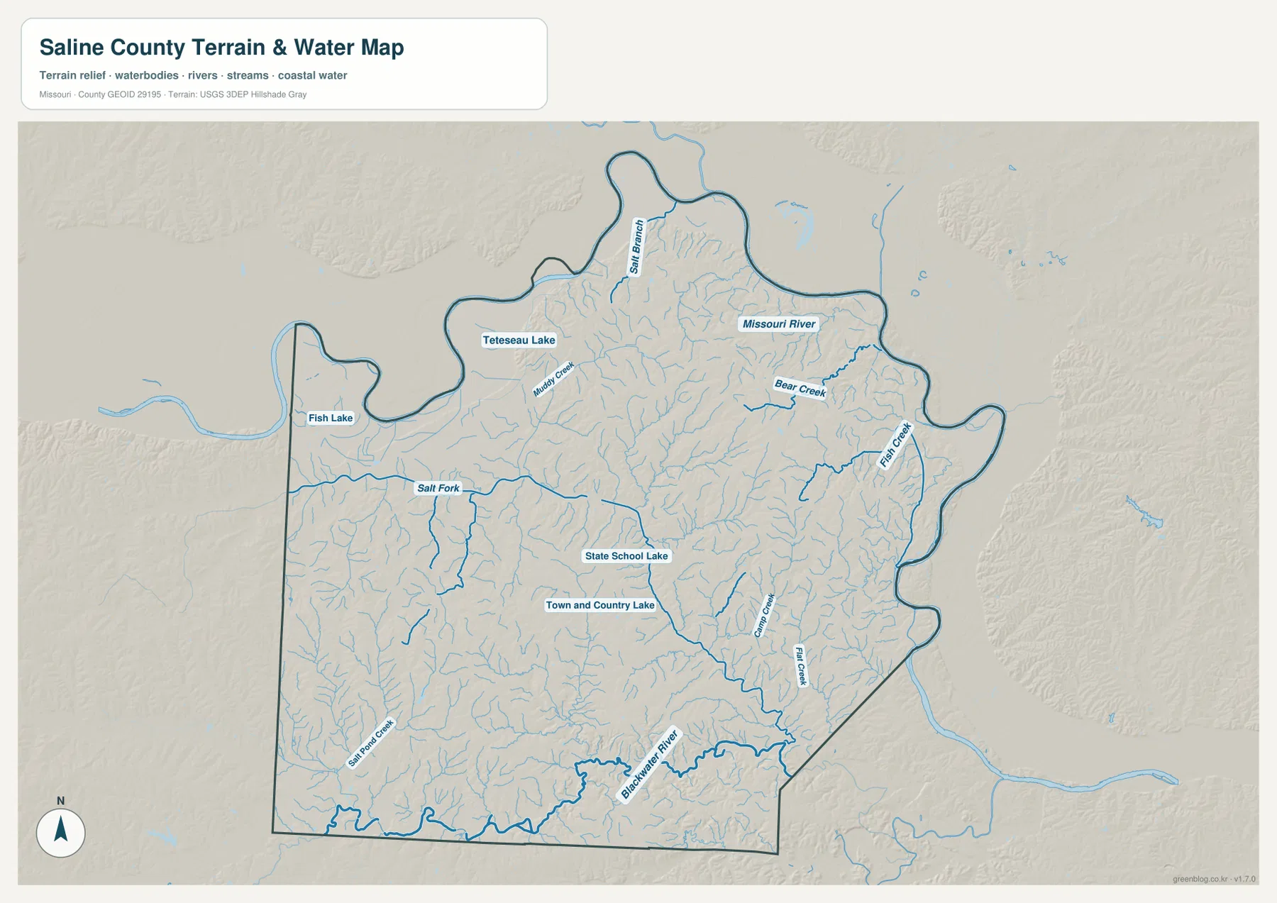
The Missouri River is the largest water feature on the terrain-and-water map, following much of the northern and eastern edge of Saline County. Broad lower ground borders the river, and northern tributaries such as Salt Branch and Bear Creek descend toward it. Tetesau Lake and Fish Lake provide additional named water references in the northwestern and western parts of the county.
Salt Fork forms a long western-central creek corridor, while Muddy Creek crosses the north-central interior. East and southeast of Marshall, Grand Creek and Flat Creek create major lower passages through the rolling terrain. Numerous shorter tributaries feed these waterways, giving the county a tightly branched stream network.
The Blackwater River runs along the southern side and forms another broad low corridor. Salt Pond Creek approaches from the southwest, while State School Lake and Town and Country Lake provide smaller central-southern landmarks. The county therefore sits between two major lowland systems with a large area of creek-cut uplands between them.
The terrain-and-water map is intended for geographic reference, not flood determination, depth analysis, navigation, parcel boundaries, or legal water boundaries. River stages and lake conditions change over time, so current flood, boating, or safety decisions should rely on the appropriate official source.
Elevation ranges from about 174 to 266 meters
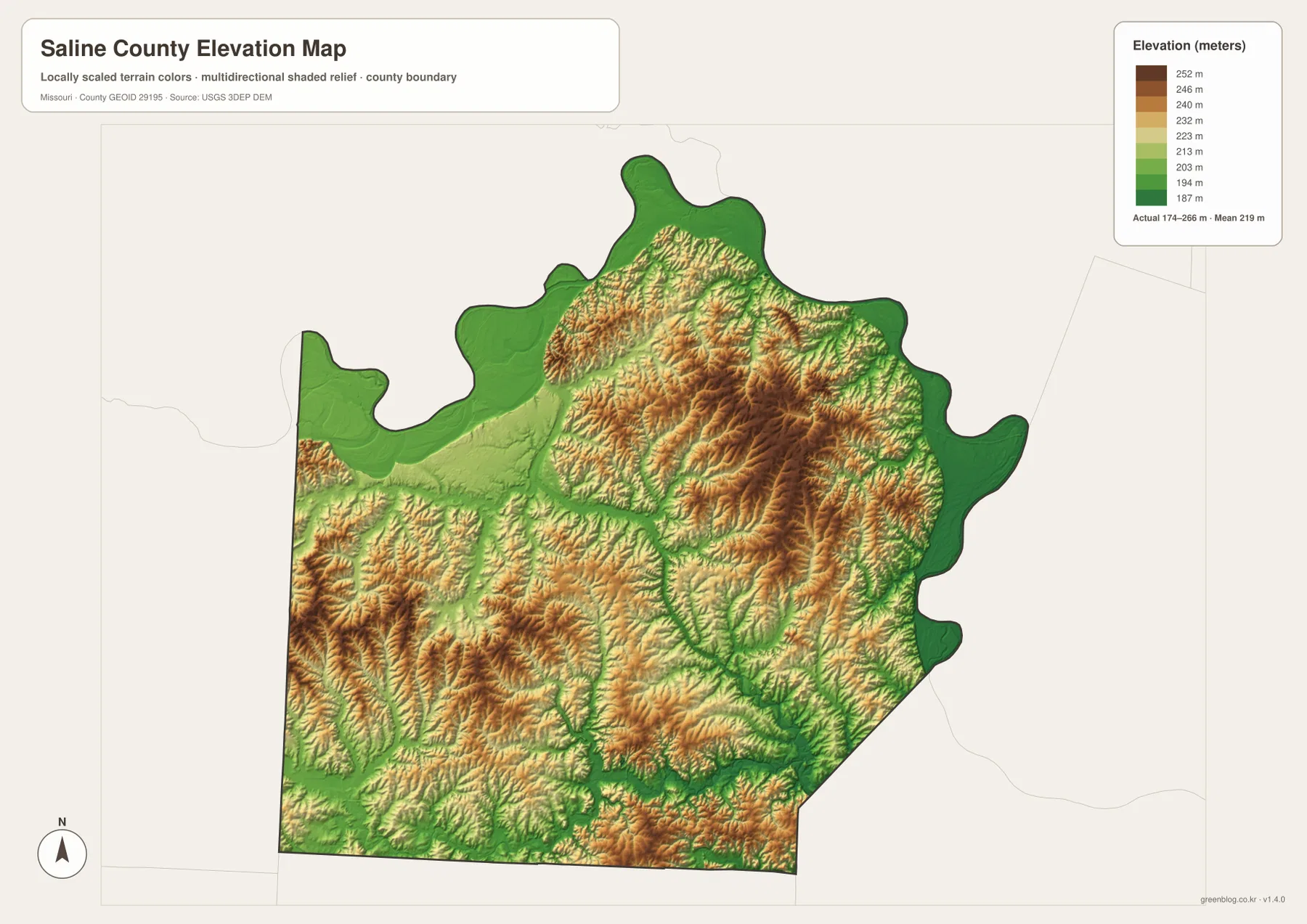
The elevation map reports an actual range of roughly 174 to 266 meters and a mean near 219 meters. The lowest dark greens follow the Missouri River along the northern and eastern edges, and another broad low area appears along the Blackwater River in the south. Between those two lowlands, warmer tan and brown colors cover much of the interior.
Some of the highest ridges occur across the central and northeastern interior, with additional elevated ground in the west. South of the Slater area and east of Marshall, tributaries cut deeply into the higher land and create a strongly dissected ridge pattern. The western side also contains higher rolling terrain before dropping toward the river-related lowlands.
Marshall itself sits within the broad interior uplands rather than inside the lowest floodplain terrain. Grand Creek and Flat Creek form lower green corridors east and southeast of the city, while Salt Fork creates another lower route through the west. The water and elevation maps line up closely wherever those named streams cross the county.
This county-scale elevation surface is useful for broad relief comparison, not for engineering, construction, drainage design, parcel-level elevation decisions, or survey-grade measurement. Site-specific work requires more detailed official elevation data or field surveying.
Compare Marshall roads with the river lowlands and interior ridges
Start with the general county map when roads and settlements matter most. Marshall and Routes 20 and 41 provide the immediate framework, after which Slater and Gilliam can be placed in the northeast, Malta Bend and Blackburn in the west, and Sweet Springs in the southwest. The city map is faster when only the six highlighted communities and their relative scale are needed.
For waterways, begin with the Missouri River and Blackwater River, then compare Salt Fork, Grand Creek, Flat Creek, and Bear Creek. Moving to the elevation map afterward shows how those streams occupy lower corridors while the center of the county remains higher and more strongly ridged.
Saline County combines a substantial regional center at Marshall with broad rural land, major river lowlands, and a dense interior stream network. The road map explains how communities connect, while the water and elevation maps show why the northern-eastern and southern edges look so different from the central uplands.
The downloadable JPG originals contain more pixels than the WebP previews embedded on the page, making them better for enlargement, A3 printing, classroom handouts, reports, and personal reference. They remain general-purpose maps, however. Legal boundaries, property ownership, live road restrictions, flood status, and precise site elevations should always be checked against the appropriate current official source.
Frequently Asked Questions
Which roads are the easiest references in Saline County?
Routes 20 and 41 around Marshall are the clearest starting points. U.S. 65 and Route 127 help organize the western side, Route 240 serves the Slater–Gilliam area, and Interstate 70 with U.S. 40 provides the main southern reference near Sweet Springs.
How much elevation change is shown across Saline County?
The elevation map shows an actual range of about 174 to 266 meters with a mean near 219 meters. Missouri River and Blackwater River lowlands are lowest, while central, northeastern, and parts of the western interior rise higher.
Which waterways are the best starting points on the terrain map?
Start with the Missouri River along the north and east and the Blackwater River in the south. Salt Fork, Grand Creek, Flat Creek, and Bear Creek then provide useful references for the major interior valleys.
Map File Information
The download ZIP contains high-resolution JPG versions of the Saline County general map, city map, terrain-and-water map, and elevation map.
- File Type: JPG
Related Maps
Sources and References
Boundary and road reference data are supported by U.S. Census Bureau TIGER/Line, water features by USGS National Hydrography, and elevation data by the USGS 3D Elevation Program. County government and local information centered in Marshall are available from the official Saline County website.
Green Map creates custom-edited map images using open geographic data sources such as geoBoundaries, Natural Earth, OpenStreetMap, and government open data. These maps are edited visual materials, not raw data files, and are provided for education, documents, presentations, and graphic reference.