Clay County lies on the north side of the Kansas City metropolitan area, but the county is far more varied than a simple suburban map suggests. Liberty anchors the south-central part of the county, Gladstone and North Kansas City sit closer to the urbanized southwest, Kearney and Smithville extend the settlement pattern northward, and Excelsior Springs occupies the eastern side. The Missouri River forms the broad southern edge, while Smithville Lake and the Fishing River system give the north and east a very different physical character. High-resolution map files are available for download in the section below.
The maps on this page can also be downloaded as a ZIP containing the original high-resolution JPG files. They are useful when you need a county-wide reference for roads and places, a cleaner comparison of the six ranked cities, a water-and-terrain view, or an elevation surface showing how the river lowlands differ from the higher interior. The sections below focus on features that are actually visible in the supplied Clay County maps rather than on generic county-map descriptions.
Table of Contents
Liberty links the urban south with Kearney and the northern towns
The southern and southwestern part of Clay County is closely tied to the Kansas City urban area. Liberty stands slightly south of the county’s center, with Gladstone, Pleasant Valley, Claycomo, and North Kansas City farther west or southwest. These places appear relatively close together and are surrounded by a denser road pattern. Moving north changes the picture: Smithville occupies the northwest, Kearney sits near the middle of the northern half, and Lawson appears near the northeast corner. Excelsior Springs is separated from the main southwestern cluster on the eastern side.
Liberty is a practical reference point because several directions become easy to understand from there. Roads lead west toward the Kansas City side, north toward Kearney, and east toward Mosby and Excelsior Springs. The map therefore shows a county with two distinct visual patterns: a more continuous urbanized area in the southwest and a set of separated communities across the north and east. That contrast is more informative than treating every labeled place as if it were equally isolated.
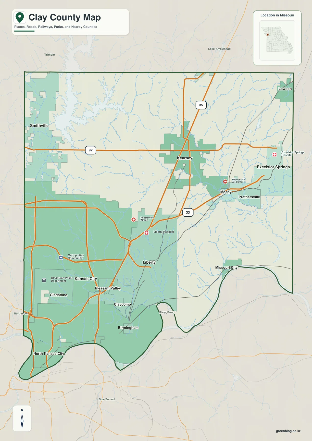
I-35 is the clearest north-south route on the map. It runs through the Kearney area and continues toward the southwestern urban zone. Route 92 crosses the northern half from the Smithville side through Kearney and farther east, while Route 33 serves the area around Mosby and the eastern communities. Looking at the road labels together with the city names makes it easier to see which places share the same travel corridor, although the map is intended as a county reference rather than turn-by-turn navigation.
The six-city index reveals a split between the southwest and outer communities
The ranked city map identifies Liberty as number one, Gladstone as number two, Kearney as number three, Smithville as number four, Excelsior Springs as number five, and North Kansas City as number six. Their positions matter as much as the ranking. Liberty and Gladstone represent the strongest concentration in the southern half, while Kearney and Smithville show how development extends north. Excelsior Springs provides a separate eastern focus, and North Kansas City occupies the narrow southwestern end near the Missouri River corridor.
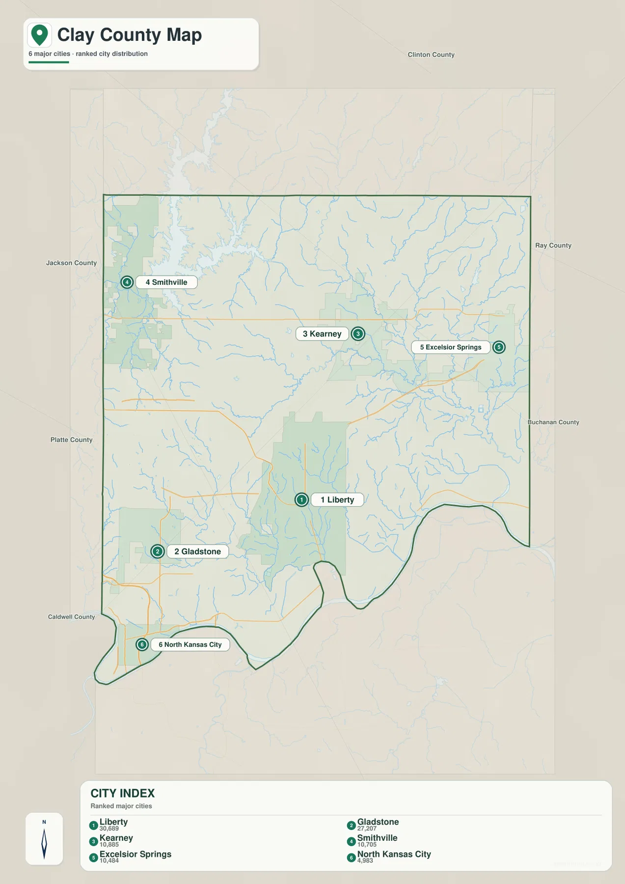
Liberty and Gladstone are both prominent, yet they occupy different parts of the urbanized south. Gladstone sits closer to the Kansas City side, while Liberty is farther east and more central within the county. North Kansas City is even farther south and west, close to the river. Those three locations explain why the lower part of Clay County looks like a connected metropolitan landscape rather than a single compact city surrounded by open land.
Kearney and Smithville are separated from that southern cluster by more open space. Kearney is easy to locate near I-35 and Route 92, while Smithville is tied visually to the large lake in the northwest. Excelsior Springs sits well to the east, beyond the Kearney corridor. The city map is a ranked distribution map, not a distance diagram, so it should not be read as a measure of driving mileage or travel time between the six communities.
Smithville Lake dominates the northwest while Fishing River shapes the east
Water features divide Clay County into several recognizable zones. Smithville Lake is by far the largest named water body in the northwest, with long branching arms that reach into the surrounding uplands. The Municipal Reservoir and Bell Lake are also labeled nearby. This concentration of open water gives the Smithville side of the county a very different appearance from the more densely developed southwestern area around Gladstone and Liberty.
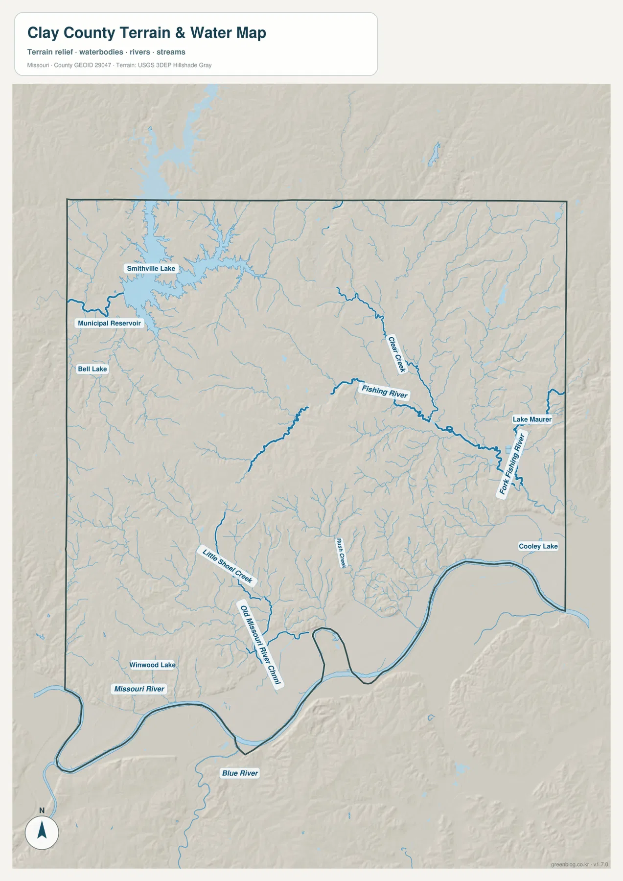
Fishing River is the most prominent stream in the central and eastern part of the water map. Clear Creek descends toward it from the north, and East Fork Fishing River joins the system farther east. The stream network branches through the same broad part of the county where Kearney, Mosby, and Excelsior Springs appear on the settlement map. Comparing the two maps helps explain why the eastern landscape contains many small valleys rather than one broad, flat surface.
The Missouri River creates the southern boundary with a series of broad bends. Little Shoal Creek and Rush Creek drain toward the lower part of the county, and smaller named waters such as Winwood Lake, Lake Maurer, and Cooley Lake add local reference points. The water map is designed to show relative location and terrain context. It is not a flood-hazard map, a parcel map, or a navigation chart, so floodplain decisions and property questions require the appropriate official source.
Elevation rises away from the Missouri River lowlands
The elevation map reports an actual range of about 214 to 331 meters, with a mean of about 269 meters. The lowest terrain follows the Missouri River along the southern boundary and extends into stream valleys. Those low areas appear in green, forming a clear contrast with the warmer colors on the ridges farther north and west. The relationship between river channels and lower elevation is especially easy to see when the elevation and water maps are viewed together.
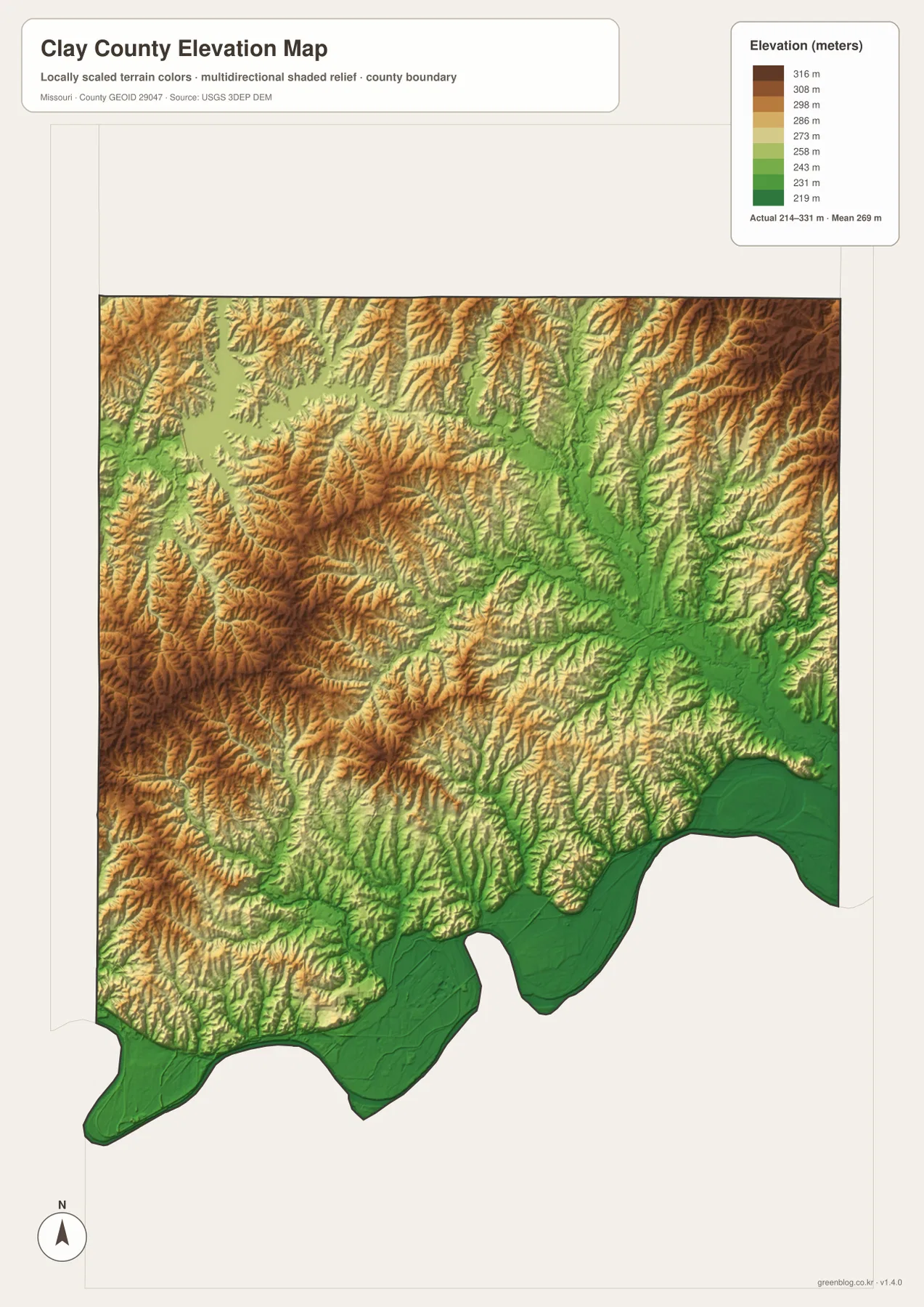
Higher ground is more common across the northwest and northeast ridges, with another broad area of elevated terrain west of the county’s center. Around Smithville Lake, narrow valleys and ridges create a deeply indented shoreline. The eastern half is also dissected by many stream valleys, so it does not read as a single flat plain. Instead, higher interfluves repeatedly separate lower drainage lines, producing the textured relief visible in the shaded surface.
This elevation map is best used for county-scale comparison. The color classes and shaded relief help identify broad lowlands, valleys, and ridges, but they are not survey-grade measurements for individual properties. Engineering design, construction elevations, drainage calculations, and legal boundary work require more precise data and professional verification. The 214–331 meter range is therefore most useful as a summary of the county’s overall relief.
Roads, water, and relief explain why each part of the county looks different
A road-only view of Clay County naturally draws attention to the busy southwest, where multiple cities and highway connections are concentrated. Adding the water map changes that impression. Smithville Lake occupies a large part of the northwest, Fishing River and its tributaries organize the east, and the Missouri River defines the southern edge. The elevation map adds another layer by showing that these water features are tied to lower valleys while the spaces between them rise into rolling ridges.
Kearney illustrates the connection well. It appears along the I-35 corridor on the county map, but it also lies near the transition into the Fishing River drainage system. Smithville is defined not only by its town label and Route 92 but also by the reservoir immediately to the north and west. Liberty belongs to the denser southern road network, yet it is still close to the lower terrain associated with the Missouri River and its tributary valleys. These relationships make the county easier to remember than a simple list of town names.
Excelsior Springs provides another useful example. On the settlement map it appears near the eastern edge, separated from the Liberty-Gladstone cluster. On the water map, the surrounding branch network of Fishing River becomes more obvious. North Kansas City, by contrast, sits at the far southwestern end close to the major river corridor. The maps therefore show both metropolitan connections and natural divisions within the same county.
Choosing the right Clay County map for a practical task
For general orientation, the county reference map is the best starting point because it combines towns, roads, the county outline, and nearby context. It works well when you need to locate Liberty relative to Smithville, trace I-35 through Kearney, or see how Excelsior Springs sits on the eastern side. The ranked city map is cleaner when the main goal is comparing the six highlighted communities without as many surrounding labels.
The terrain-and-water map is the better choice for studying Smithville Lake, Fishing River, the Missouri River, and smaller tributaries. Pair it with the elevation map when you want to understand why the southern river corridor is low and why the northern interior contains more rolling relief. For classroom use or presentations, placing the city map next to the water or elevation view can make the contrast between settlement patterns and physical geography easier to explain.
The maps should also be interpreted at the scale for which they were designed. A county boundary does not perfectly match the functional Kansas City metropolitan area, and a generalized elevation surface cannot replace site-specific surveying. Likewise, the city index is not a route planner. Treating each map as a different reference layer produces a more accurate picture of Clay County than asking one image to answer every geographic question.
Frequently Asked Questions
Can I see Smithville Lake and the Missouri River on the same map?
Yes. The terrain-and-water map shows Smithville Lake in the northwest and the Missouri River along the southern boundary. It also labels Fishing River, Clear Creek, East Fork Fishing River, and several smaller lakes and streams, so it is the most useful of the supplied maps for comparing major and minor water features.
Which map is best for comparing Liberty, Kearney, and Smithville?
Use the county reference map when roads matter because it shows Liberty, Kearney, Smithville, I-35, Route 92, and other nearby places together. If you only need a cleaner view of the principal cities, the ranked city map is easier to scan and also includes Gladstone, Excelsior Springs, and North Kansas City.
Is the elevation map accurate enough for property surveying?
No. It is a county-scale terrain reference showing an approximate 214–331 meter range and broad differences between river lowlands and higher ridges. Property surveys, engineering plans, construction elevations, and detailed drainage work require more precise official data and professional measurement.
Map File Information
The ZIP contains the original high-resolution JPG versions of the Clay County reference map, ranked city map, terrain-and-water map, and elevation map.
- Included Files: Use only the versions confirmed in the article and supplied images
- File Type: Use the confirmed download contents
- Intended Use: Printing, education, presentations, and map-based projects
Related Maps
Sources and reference links
County services and local government information are available from the official Clay County website. Administrative boundary data can be checked through the U.S. Census Bureau TIGER/Line program. Water references are available from USGS National Hydrography, and elevation data can be reviewed through the USGS 3D Elevation Program.
Green Map creates custom-edited map images using open geographic data sources such as geoBoundaries, Natural Earth, OpenStreetMap, and government open data. These maps are edited visual materials, not raw data files, and are provided for education, documents, presentations, and graphic reference.