Grant County sits in western Minnesota, where a broad low western half gives way to a more rolling, lake-filled landscape toward Ashby and the eastern county line. Elbow Lake is the most useful point of orientation because several numbered roads meet near the city and the other mapped communities spread out around it. The supplied maps make it possible to compare that settlement pattern with the county’s rivers, lakes, and roughly 303–427 meter elevation range.
High-resolution JPG versions of the maps used on this page are available together in one downloadable ZIP file. Rather than treating each map as an isolated graphic, it helps to start with the road network around Elbow Lake, then compare the town distribution with the Mustinka, Pomme De Terre, and Chippewa river systems and the higher ground in the east.
Table of Contents
Roads and county orientation around Elbow Lake
Elbow Lake appears a little north of the county’s center and provides the clearest anchor on the general map. Routes 79 and 21 meet near the city, while Route 8 runs south toward Route 54. Wendell lies to the northwest, Barrett to the southeast, Herman and Norcross occupy the southwest side, Hoffman is near the southeastern edge, and Ashby sits close to the northeast corner. That spread makes Grant County easier to understand by using Elbow Lake as a central reference rather than trying to memorize the outer boundary first.
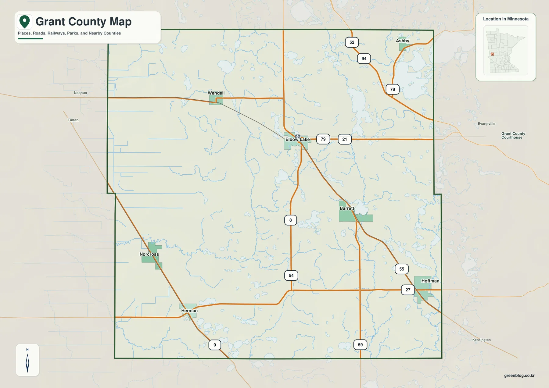
The northeastern road pattern is notably different from the western side. Ashby is near Routes 78 and 94, with Route 52 shown farther north. East of Elbow Lake, Route 21 continues toward the eastern part of the county, while the Hoffman area is served by Routes 27 and 55. Route 59 extends south from that area, and Route 9 is visible near Herman. These numbered roads provide a practical way to connect small communities that otherwise look widely separated on the map.
The county boundary is mostly straight on the west but has visible steps and offsets on the east and southeast, so the outline is not a simple rectangle. Neighboring county names around the map include Wilkin, Otter Tail, Douglas, Pope, Stevens, and Traverse counties. Those labels are useful for regional orientation, especially when a reader wants to understand which Grant County town is closest to a neighboring county. The map is not a live traffic product, however, so construction, closures, and current driving conditions should be checked with up-to-date transportation sources.
Six mapped communities spread across a lightly settled county
The city map simplifies the background and highlights six places: Elbow Lake, Hoffman, Herman, Ashby, Barrett, and Wendell. Elbow Lake occupies the north-central interior, while Hoffman and Herman sit far apart in the southeastern and southwestern parts of the county. Ashby is close to the northeastern edge, Wendell is northwest of Elbow Lake, and Barrett falls between Elbow Lake and Hoffman. The result is a distributed settlement pattern rather than a single line of towns.
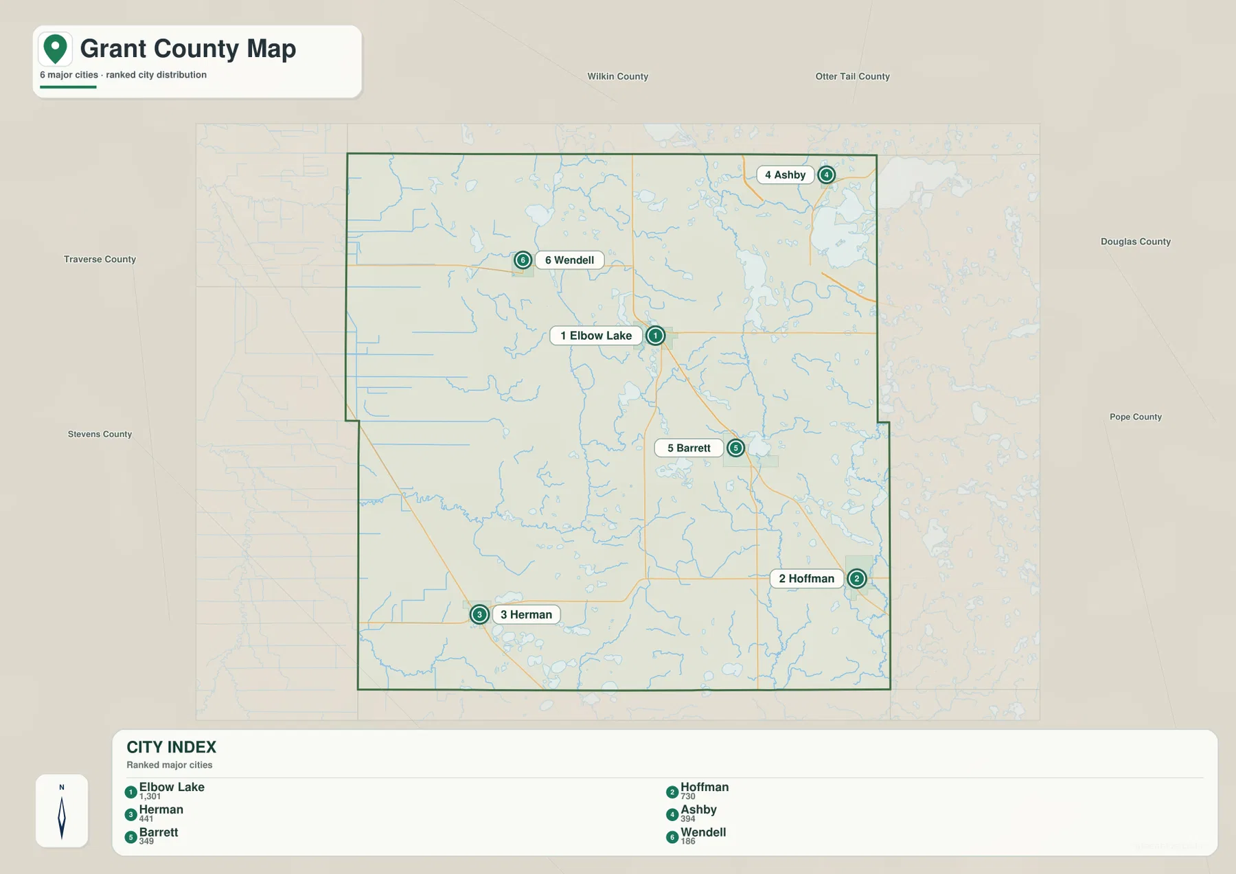
The CITY INDEX printed on the supplied map lists Elbow Lake at 1,301, Hoffman at 730, Herman at 441, Ashby at 394, Barrett at 349, and Wendell at 186. These numbers are best treated as the index values embedded in the map rather than as a claim about the latest official population totals. Their main value here is comparative: Elbow Lake is shown as the largest of the six mapped communities, while the remaining places are much smaller and widely separated.
Location is more important than rank when using this map for orientation. Ashby is positioned toward the Otter Tail County side of the northeast, Herman toward the Stevens County side of the southwest, and Hoffman close to the Pope County side of the southeast. Wendell and Barrett fill two very different positions northwest and southeast of Elbow Lake. That makes the city map especially useful for worksheets, presentations, or quick regional reference where road detail would otherwise distract from the town pattern.
The city map should not be read as a travel-time or driving-distance chart. A short visual gap between two markers does not account for road bends, lakes, streams, intersections, or the actual route a driver must take. For trip planning, the clearer approach is to use this simplified map to identify direction and then return to the general map for the numbered roads that connect the communities.
Lakes and rivers from Pelican Lake to the Chippewa River
Water features become more prominent toward the eastern half of Grant County. Pelican Lake and Pelican Creek are labeled in the northeast, with Pomme De Terre Lake farther south. Round Lake, Long Lake, Cormorant Lake, and Barrett Lake occupy the central and east-central interior. Compared with the western side of the county, this area has a denser mix of named lakes and larger natural drainage features.
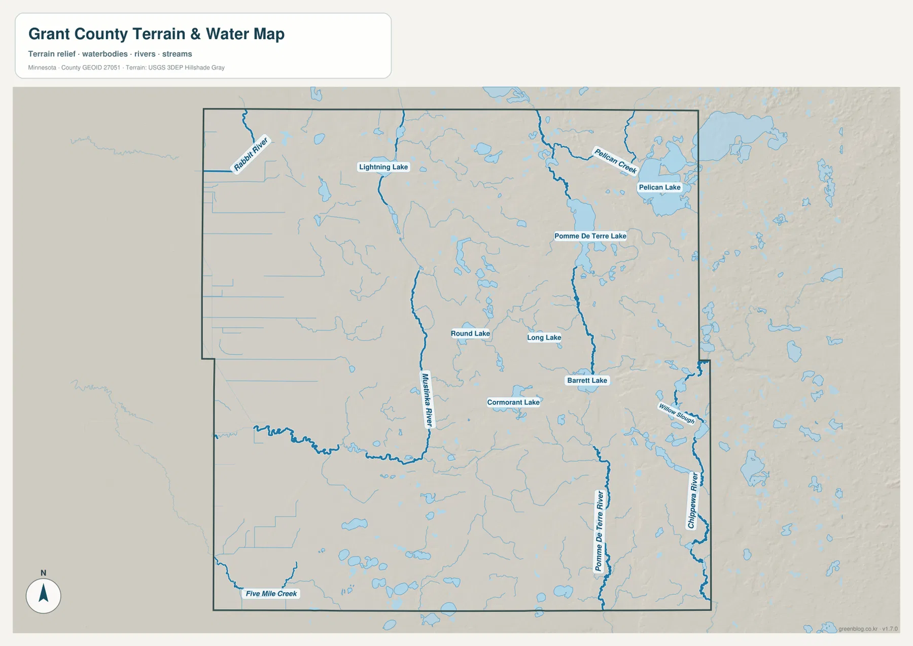
The Mustinka River is one of the most noticeable waterways in the center-west. It runs through a long north-south corridor before connecting with smaller channels toward the southwest. Rabbit River is labeled near the northwestern edge, and Five Mile Creek appears in the southwest. These features give the western half a different character from the east: fewer large named lakes are visible, but narrow streams and drainage lines cross broad, relatively low terrain.
The southeastern drainage is organized around the Pomme De Terre River and the Chippewa River. The Pomme De Terre River runs south through the eastern interior, while the Chippewa River follows close to the eastern boundary. Willow Slough is labeled between the river systems near the Hoffman side of the county. They are separate waterways, so the map is useful for keeping their courses distinct when studying the eastern part of Grant County.
This water map is intended for general geographic reference. It does not show flood-hazard boundaries, water depth, navigability, parcel ownership, shoreline regulations, or fishing rules. Anyone planning boating, fishing, emergency response, or work near a water body should consult current state, county, and USGS information. On this page, the map is most useful for understanding how towns and roads sit among lakes, river valleys, and smaller creeks.
A 303–427 meter elevation range and a clear east-west contrast
The supplied elevation map reports an actual range of about 303 to 427 meters, with a mean near 348 meters. Green shades dominate the western half, indicating lower terrain, while yellow, orange, and brown become more common toward the east and northeast. The highest-looking terrain is concentrated near the eastern side, where broad uplands are cut by narrow lower valleys.
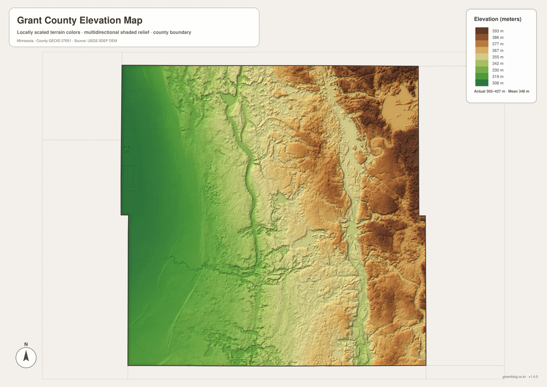
The western green area is relatively gentle, but it is not perfectly flat. Shallow channels and subtle depressions follow smaller streams, and the Mustinka River occupies a distinct lower corridor that can be matched to the water map. This is a useful example of why the elevation and water maps work well together: a river line that seems simple on one map becomes a broader valley when the relief shading is added.
Farther east, the Pomme De Terre River also follows a lower north-south corridor, but the land on both sides rises more strongly than it does around the Mustinka. The northeastern section near Ashby and Pelican Lake contains broad areas of higher relief, and the eastern boundary shows repeated valleys cut into upland terrain. That contrast helps explain why the eastern half looks more textured and irregular even though Grant County does not contain mountain terrain.
The elevation surface is designed for county-wide comparison, not site engineering. It should not be used as a substitute for surveyed elevations, building grades, drainage design, road-slope measurements, or parcel-level terrain data. For precise elevation work, USGS 3D Elevation Program products or professional survey data are the appropriate sources. Here, the value of the map is in showing where the county is broadly low, where it rises, and how river corridors cut through that higher ground.
Reading roads, water, and relief together
The general road map alone presents Grant County as a set of small towns linked by numbered roads. Adding the water and elevation maps changes that picture. Wendell, Herman, and Norcross occupy the lower, more open western side, while the route from Elbow Lake toward Ashby crosses into a landscape with more lakes and visibly higher ground. The difference is gradual, but it is one of the clearest county-wide patterns in the supplied maps.
The northeast is a good place to compare all four views. On the road map, Ashby is reached through the Route 78 and 94 area. On the water map, Pelican Lake and Pelican Creek give that corner a strong hydrologic identity. On the elevation map, the same region is among the higher parts of the county. None of those facts is as clear when the maps are viewed separately as when the locations are matched across them.
A similar comparison works in the south. Herman sits in the lower southwest, while Hoffman is closer to the Pomme De Terre and Chippewa river systems and to more elevated ground in the southeast. Elbow Lake lies between those two broad settings and functions well as the central reference for explaining the county. This makes the map set useful not only for locating towns but also for showing why the eastern and western parts of Grant County look different.
Choosing the best map for a specific task
Use the general county map when roads, boundaries, and town locations need to appear together. It is the best starting point for tracing how Elbow Lake connects with Ashby, Hoffman, Herman, Barrett, Wendell, and Norcross. The city map is cleaner when the goal is simply to compare the six highlighted communities or prepare a presentation where road and water detail would make labels harder to read.
The water map is the better choice for questions about Pelican Lake, Pomme De Terre Lake, the Mustinka River, the Pomme De Terre River, or the Chippewa River. Pair it with the elevation map when the relationship between waterways and valleys matters. The elevation view shows why some river corridors appear as long low strips and why the eastern landscape has more pronounced relief than the western side.
For printing or editing, the original JPG files in the ZIP are more useful than the smaller WebP images displayed in the article. Each JPG is 3638 by 2572 pixels, and the archive contains the county, city, water, and elevation maps. A classroom worksheet may need only the city map, while a local geography handout can combine the general map with the water or elevation view without forcing every type of information into one graphic.
When to use Grant County’s official information instead
Grant County’s official website provides current government and administrative information, and county contact information places the courthouse in Elbow Lake. The maps on this page are designed as geographic overview and download resources, not replacements for legal or administrative records. Parcel boundaries, taxation, permits, election districts, official road documents, and other decisions that require current authority should be checked against county or state records.
The county’s View page also provides access to map- and land-related items, including an agricultural land/perimeter map entry. That makes it a useful next step when a reader needs official local material after using the maps here for orientation. Keeping the purposes separate is important: the downloadable maps on this page explain location, water, and relief, while official county documents should control when an administrative or legal detail matters.
Frequently Asked Questions
Which map is best for finding Elbow Lake and the other major towns?
The city map is the cleanest choice for quickly comparing Elbow Lake, Hoffman, Herman, Ashby, Barrett, and Wendell. If you also need the numbered roads that connect those places, use the general county map alongside it.
Is eastern Grant County higher than the western side?
On the supplied elevation map, the western half is generally shown in lower green shades, while the east and northeast contain more yellow, orange, and brown higher ground. The displayed county-wide range is about 303–427 meters with a mean near 348 meters. Precise site elevations should still be checked with USGS data or a survey.
Can I see both the Pomme De Terre River and Chippewa River on the water map?
Yes. The Pomme De Terre River is labeled through the southeastern interior, while the Chippewa River runs close to the eastern boundary. Pomme De Terre Lake, Barrett Lake, and Willow Slough are also visible, making the map useful for comparing the major water features of eastern Grant County.
Map File Information
Download the original high-resolution JPG versions of the four Grant County maps shown in this article as one ZIP file.
- Included Files: county map, city map, water map, elevation map
- Printable Size: each JPG is 3638 × 2572 px
- File Type: ZIP containing 4 JPG files
Related Maps
Sources and references
- Grant County, Minnesota official website – county government and public information
- Grant County View – county map and land-related resources
- U.S. Census Bureau TIGER/Line Shapefiles – boundary, road, and place data
- USGS National Hydrography – river, stream, and water data
- USGS 3D Elevation Program – elevation data and products
Green Map creates custom-edited map images using open geographic data sources such as geoBoundaries, Natural Earth, OpenStreetMap, and government open data. These maps are edited visual materials, not raw data files, and are provided for education, documents, presentations, and graphic reference.