Hampshire County stretches across western Massachusetts from the uplands near the Berkshire County side to the Ware area in the east. Its easiest point of orientation is the Connecticut River valley, where Northampton sits on the western side and Amherst lies to the east. Route 9 links those two centers, while I-91 runs north and south near Northampton and Hatfield. Farther west, Routes 66, 112, and 143 cross more rugged country; farther east, Route 202 helps connect Granby and Belchertown as the settlement pattern becomes more dispersed. High-resolution map files are available for download in the section below.
This page provides three complementary references for the county: a general boundary-and-road map, a simplified city-connections map centered on Amherst Town, and a terrain-and-water map showing rivers, lakes, and shaded relief. The original high-resolution JPG versions of the maps can also be downloaded together in a ZIP file. They are designed for regional orientation, printing, classroom use, and general reference rather than parcel research, flood determination, engineering measurement, or turn-by-turn navigation.
Table of Contents
Route 9 and I-91 make the central valley the easiest place to begin
On the general county map, Northampton is the most useful starting point because several important features meet nearby. The city lies just west of the Connecticut River, Route 9 crosses through the area and continues toward Amherst, and I-91 passes north-south close to Northampton and Hatfield. Easthampton appears to the south with Route 10, while Hatfield provides another clear label to the north. Once those places are located, the central part of Hampshire County becomes much easier to read than if the irregular county outline is traced first.
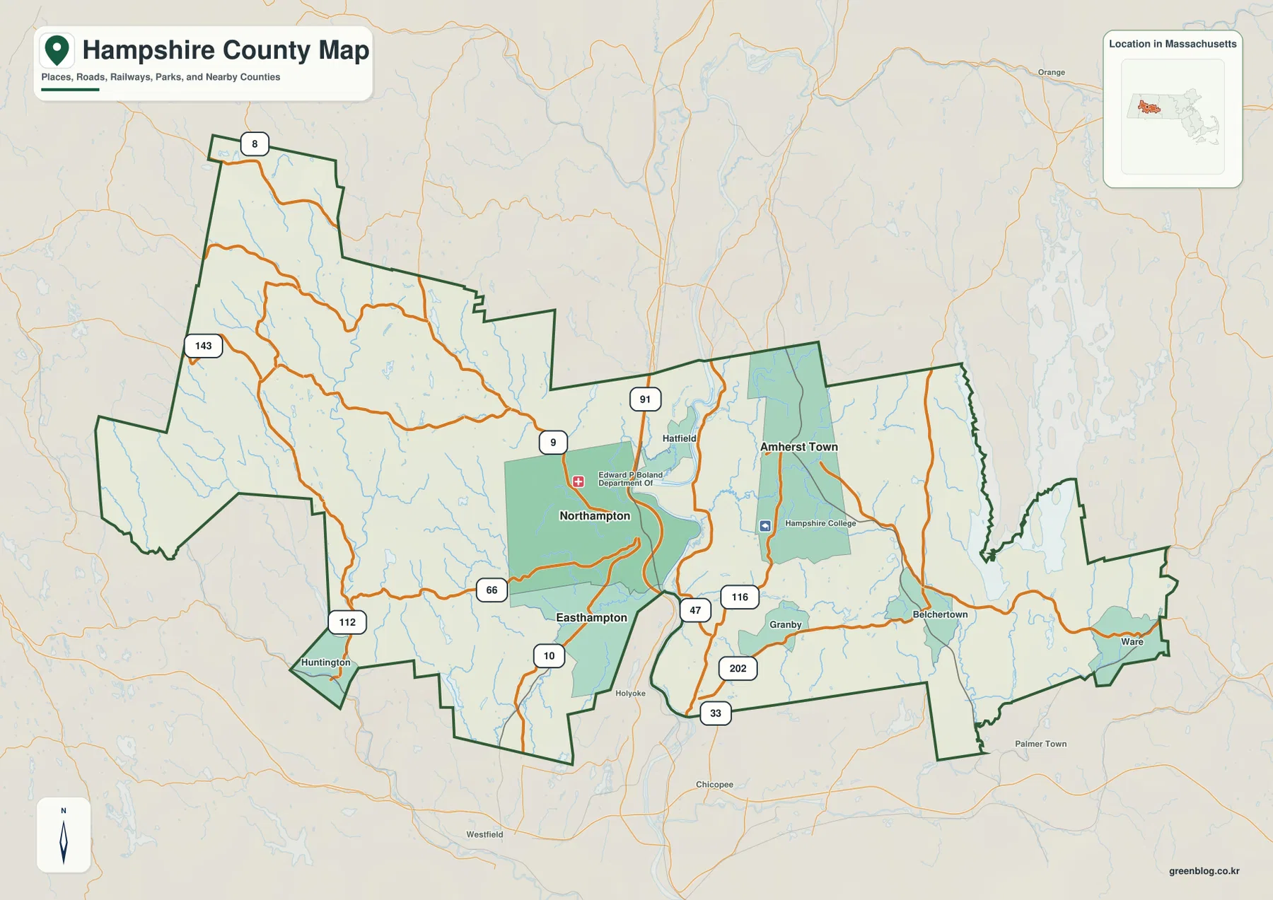
Route 9 is the strongest east-west reference through the central population corridor. It reaches Northampton from the west, crosses the Connecticut River, and continues through the Amherst side of the county. I-91 provides the contrasting north-south line and is especially useful around Northampton and Hatfield. Route 47 appears along the eastern side of the river in the central-southern area, and Route 116 passes through Amherst before continuing toward Granby. Together, these routes create a clear framework for understanding where the county’s best-known communities sit in relation to one another.
The western part of Hampshire County looks very different. Huntington is labeled near the southwestern side, and Routes 112 and 66 approach the central valley through a landscape with fewer large settlement labels. Route 143 and Route 8 appear farther north and west. The roads bend more often than they do around Northampton and Amherst, which becomes easier to understand when the terrain-and-water map is viewed later: this side of the county contains stronger relief, narrow valleys, and the Westfield River system.
To the east, Amherst is only the beginning of the county rather than its endpoint. Route 202 continues through the Granby-Belchertown area, while Route 9 remains an important line farther north. Ware is marked near the eastern edge and serves as a useful reference for the part of Hampshire County that is farthest from Northampton. Small streams and ponds become more noticeable on the eastern half of the map, and community labels are more widely spaced than in the central valley. Looking all the way to Ware prevents the county from being reduced to only the Amherst-Northampton area.
The southern boundary is irregular around Easthampton, Granby, and the sections bordering Hampden County. Easthampton lies south of Northampton near Route 10, while Granby sits between the Route 116 and Route 202 corridors. Places outside the county, including Holyoke, Chicopee, and Westfield, also appear in the surrounding basemap and help position Hampshire County immediately north of the Springfield-centered part of western Massachusetts. The outline is useful for regional orientation, but it should not be substituted for a legal municipal or parcel boundary dataset.
The value of the general map is that it keeps roads, communities, boundary context, and the basic water network together. A practical way to use it is to find Northampton and Amherst first, follow Route 9 between them, then extend west toward Huntington and east toward Belchertown and Ware. Readers who need only a quick comparison among the three highlighted population centers may prefer the city map, while readers interested in rivers and terrain will get more detail from the terrain-and-water reference.
The Amherst hub map highlights short straight-line links to Northampton and Easthampton
The city-connections map removes most of the smaller labels and treats Amherst Town as the hub. Northampton is shown west of Amherst, across the central river corridor, while Easthampton is southwest of Northampton. The simplified design is useful when a reader wants to understand the relative placement of the county’s three highlighted centers without sorting through every highway and minor road. It also makes the contrast between the concentrated central valley and the much broader rural county area immediately visible.
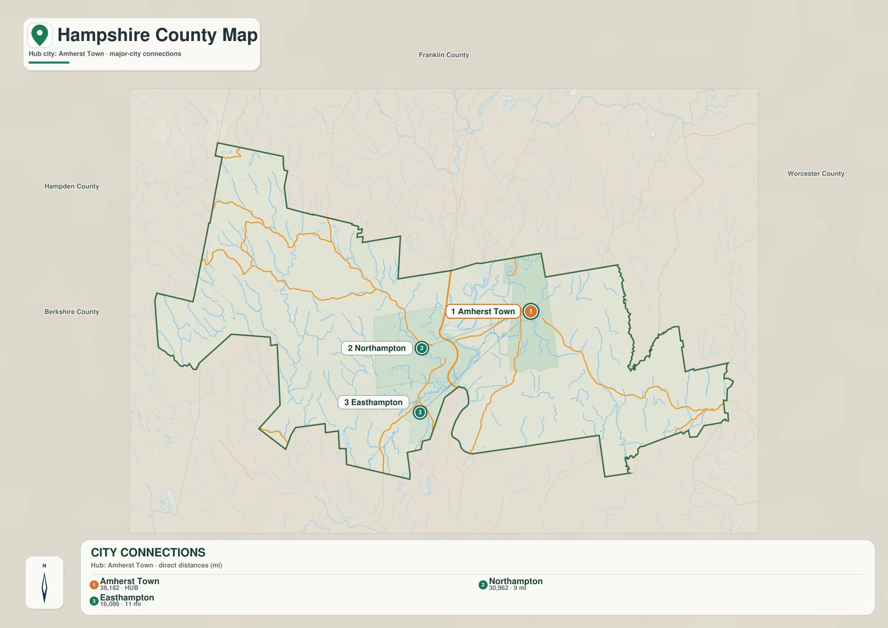
The CITY CONNECTIONS panel identifies Northampton at about 9 miles from the Amherst hub and Easthampton at about 11 miles. Those values are straight-line distances, not driving distances. A real trip must follow bridges and roads, so a route between Amherst and Northampton, for example, will not be identical to the line drawn on the map. The connector lines should therefore be read as a quick geographic comparison rather than as recommended travel routes.
The map also prints values of 38,182 for Amherst Town, 30,962 for Northampton, and 16,086 for Easthampton. These should be treated as figures from the dataset used to build this particular map, not as a guarantee of the latest official population. Population estimates change over time, and the U.S. Census Bureau’s current Hampshire County and place data are more appropriate when the exact present-day number matters. The city map is most reliable here as a location-and-connection graphic.
The relationship between Amherst and Northampton becomes more meaningful when the general and water maps are considered together. Amherst is east of the Connecticut River, Northampton is west of it, and Route 9 ties the two sides together. Easthampton lies south of Northampton near the Manhan River and Route 10. That combination of roads and waterways explains the central settlement pattern more clearly than the city ranking alone. It also prevents the straight connector between the cities from being mistaken for a road or rail line.
Mass.gov’s statewide cities-and-towns resource identifies both Amherst and Northampton as Hampshire County communities. Amherst is widely associated with its colleges and universities, while Northampton has its own strong educational and cultural identity. Those details help explain why the two names are prominent on regional maps, but this county map is not a campus guide or a visitor map. For a specific building, museum, trailhead, or parking area, the responsible institution’s current map is the better source.
Waterways separate the western uplands, Connecticut valley, and eastern interior
The terrain-and-water map adds a layer that road labels alone cannot provide. The Connecticut River is the dominant central feature, running south through the broad valley between the Northampton and Amherst sides of the county. Shaded relief is relatively subdued close to that corridor. In the west, the surface becomes much more rugged around the Westfield River and its tributaries. The eastern half has rolling relief and a different network of small streams, ponds, and the Ware River near the far side of the county.

The Westfield River provides the clearest organizing feature on the western side. Damon Pond, Pine Island Lake, Norwich Lake, and White Reservoir are also labeled in this part of the county. Relief shading is stronger and more tightly spaced around the river valleys, producing a visual contrast with the open Connecticut River corridor. When compared with the general road map, that terrain helps explain why western routes such as 112 and 143 take more winding paths and why major settlement labels are less densely clustered there.
Closer to the central valley, several smaller rivers become useful references. The Manhan River is labeled near the Easthampton side, the Mill River appears north of the central Northampton-Amherst corridor, and the Fort River is visible east of the Connecticut River near Amherst. Lake Warner is marked to the north of Amherst. These features are easy to overlook on the general map, but the water layer makes their relationships much clearer and shows how many smaller drainages feed toward the major valley system.
The eastern side belongs to a different visual pattern. Ware River is labeled near the county’s eastern edge, with Beaver Lake nearby, and Forge Pond appears farther west in the interior. Numerous small blue lines branch through the Belchertown-Ware side, while the hillshade shows rolling ground rather than the deeper western relief. This makes it useful to think of Hampshire County in three broad parts: western uplands around the Westfield River, the central Connecticut River valley, and an eastern interior with the Ware River and smaller lake-and-stream systems.
The Connecticut River is more than a cartographic centerline for the county. Massachusetts’ Connecticut River Greenway State Park has its headquarters in Northampton and connects river-access areas and parks along the river. That official resource gives real-world context to the river corridor shown on the map. Still, the terrain-and-water graphic on this page is only a regional reference. It does not provide channel depths, flood boundaries, water quality, navigation restrictions, dam operations, or legal shoreline limits.
The shaded background should also be interpreted carefully. It shows relative terrain form, not survey-grade elevation. The stronger western relief, flatter-looking central valley, and rolling eastern interior are useful regional comparisons, but exact elevation or slope at a property or trail point requires a dedicated elevation dataset. Likewise, the width of a blue river line on the map is a symbol and should not be treated as the actual width or discharge of the waterway.
Which Hampshire County map works best for a specific task?
For first-time orientation, the general map is the most complete starting point. It shows enough roads and communities to locate Northampton, Amherst, Easthampton, Hatfield, Granby, Belchertown, Ware, and Huntington while keeping the county outline visible. It is well suited to a regional overview, a class handout, or a printed reference where road numbers matter. The map should not be used to determine property lines or current traffic conditions, but it is effective for understanding how the central valley relates to the county’s western and eastern ends.
The city-connections map is better when the only goal is to explain where Amherst, Northampton, and Easthampton sit relative to one another. Its straight-line connectors and limited labeling make it cleaner for a presentation or quick comparison. The terrain-and-water map is the better choice for discussing the Connecticut River, western uplands, eastern waterways, lakes, and the differences in relief across the county. Choosing the map by question is more useful than trying to make one graphic answer every type of geographic question.
For printing, the high-resolution JPG files in the downloadable ZIP will generally produce a sharper result than the web-sized images embedded in the article. The three files preserve the same geographic themes shown here while allowing a reader to select only the version needed for a project. Current traffic, emergency conditions, flood risk, regulated water areas, and legal land boundaries should always be checked through the current authoritative source for that subject.
Frequently Asked Questions
What is the easiest way to locate Amherst and Northampton on the county map?
Start with Route 9 on the general map. Northampton is close to the west side of the Connecticut River, and Amherst lies east of the river along the same broad corridor. The city-connections map is useful for a simpler comparison, but its connector is a straight-line reference rather than a driving route.
Can the Westfield River and Ware River be compared on the same map?
Yes. The terrain-and-water reference shows the Westfield River in the rugged western part of Hampshire County and the Ware River near the eastern edge. The Connecticut River runs through the central valley between those areas, so the map is especially useful for comparing the county’s western, central, and eastern water systems.
Do the 9-mile and 11-mile city connections represent driving distances?
No. The city map uses direct straight-line distances from the Amherst Town hub: about 9 miles to Northampton and about 11 miles to Easthampton. Actual road trips depend on bridges, road layout, chosen endpoints, and traffic. Use a current navigation or transportation source when planning a drive.
Map File Information
The ZIP contains the original high-resolution JPG versions of the general Hampshire County map, the city-connections map, and the terrain-and-water reference map described on this page.
- Included Files: general county map, city-connections map, terrain-and-water reference map
- File Type: JPG
Related Maps
Sources and References
The following official resources are useful for checking Hampshire County community context, current statistics, Connecticut River information, administrative boundaries, and hydrography.
- Mass.gov – Cities and Towns of the Commonwealth of Massachusetts
- U.S. Census Bureau – Hampshire County QuickFacts
- Mass.gov – Connecticut River Greenway State Park
- U.S. Census Bureau TIGER/Line Shapefiles
- USGS National Hydrography
Green Map creates custom-edited map images using open geographic data sources such as geoBoundaries, Natural Earth, OpenStreetMap, and government open data. These maps are edited visual materials, not raw data files, and are provided for education, documents, presentations, and graphic reference.