Cedar County sits in eastern Iowa, with Tipton near the center, U.S. 30 crossing the northern tier, I-80 running across the south, and a dense network of creeks draining toward larger river valleys. This page brings those pieces together so you can locate Tipton, West Branch, Durant, Mechanicsville, Clarence, Lowden, Bennett, and Stanwood while also seeing the Cedar River, central creek systems, and the county’s elevation differences. A ZIP containing the original high-resolution JPG map files is available for download, which is useful when the smaller web images are not large enough for printing or close inspection.
The geography is more varied than a quick road map suggests. The supplied terrain-and-water map places the Cedar River mainly along the western and southwestern side of the county, while Rock Creek, Crooked Creek, Sugar Creek, Bennett Creek, and other smaller streams divide the interior into many narrow valleys. The elevation surface ranges from about 192 to 292 meters. Higher ground is most noticeable across the northwest and north-central part of the county, while lower green corridors follow the Cedar River and several creek valleys farther south and east.
Table of Contents
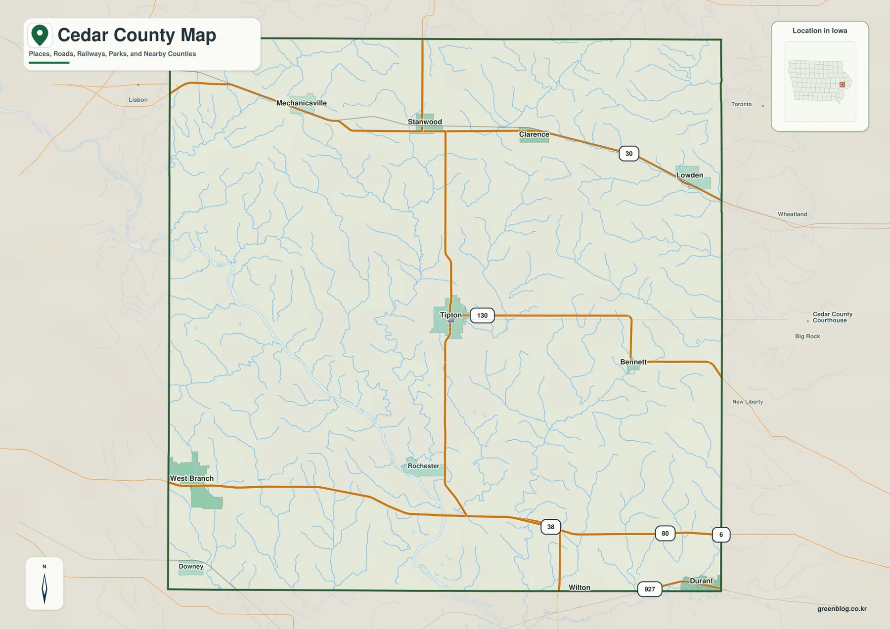
Tipton anchors the county between U.S. 30 and I-80
Tipton is the easiest place to begin on the general county map because it lies near the middle of Cedar County and connects several useful reference roads. Iowa 38 runs through the Tipton area in a north-south direction, while Iowa 130 extends east toward Bennett. From Tipton, moving north brings the map toward the U.S. 30 corridor, where Stanwood and Clarence sit along the route and Mechanicsville lies farther west. Lowden appears near the northeastern side of the county, making U.S. 30 a practical line for comparing the northern communities.
The southern pattern is different. I-80 crosses Cedar County from the West Branch area on the southwest side toward Durant at the southeast edge. Iowa 38 meets this southern corridor after leaving Tipton, so the highway provides a clear link between the county center and the interstate. This creates two strong east-west road references within one county: U.S. 30 in the north and I-80 in the south. The towns are not clustered around a single corridor, which is why using Tipton as a central anchor makes the rest of the map easier to understand.
The map also gives enough surrounding context to keep boundary locations clear. Jones County is labeled to the north, Clinton and Scott counties to the east, Muscatine County to the south, and Johnson and Linn counties to the west. That is especially helpful around West Branch and Durant, which sit close to the county edge. The road lines on this page are intended for geographic orientation rather than turn-by-turn travel planning, so current construction, closures, and driving conditions should be checked with current transportation information.
Six ranked cities show how settlement is spread across the county
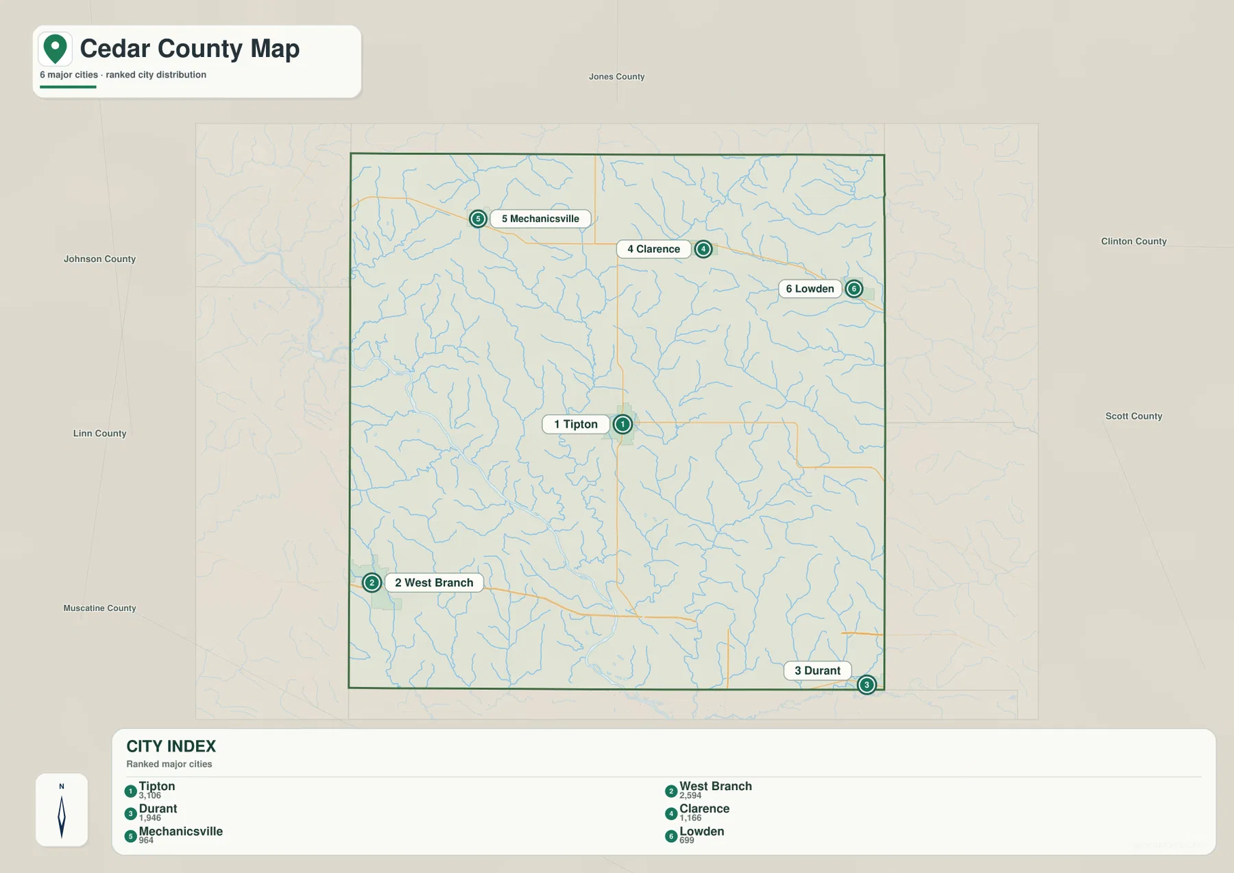
The supplied city-distribution map highlights six communities and prints a comparison value for each one: Tipton 3,106, West Branch 2,594, Durant 1,946, Clarence 1,166, Mechanicsville 964, and Lowden 699. These are values printed on the provided map and should not be treated as a substitute for a current Census estimate. Their main value here is geographic. The ranking makes it easy to see that the largest highlighted places are separated across the center, southwest, southeast, and northern part of Cedar County rather than concentrated in one urban area.
Tipton occupies the central position. West Branch lies near the southwestern boundary, and Durant sits close to the southeastern corner, so those two communities help define the width of the county’s southern side. Mechanicsville is in the northwest, Clarence lies farther east across the northern tier, and Lowden is the farthest east of the six ranked places. When the city map is viewed after the road map, the relationship becomes straightforward: the northern group aligns generally with the U.S. 30 side of the county, while West Branch and Durant are tied to the I-80 side.
Cedar County’s official community list includes eight incorporated communities: Bennett, Clarence, Durant, Lowden, Mechanicsville, Stanwood, Tipton, and West Branch. Bennett and Stanwood are visible on the general map even though they are not among the six places emphasized by the ranked city map. That difference is useful rather than contradictory. The city index provides a simplified comparison of the more prominent places in the supplied dataset, while the general map gives broader settlement and road context.
Cedar River low ground differs from the interior Rock Creek valleys
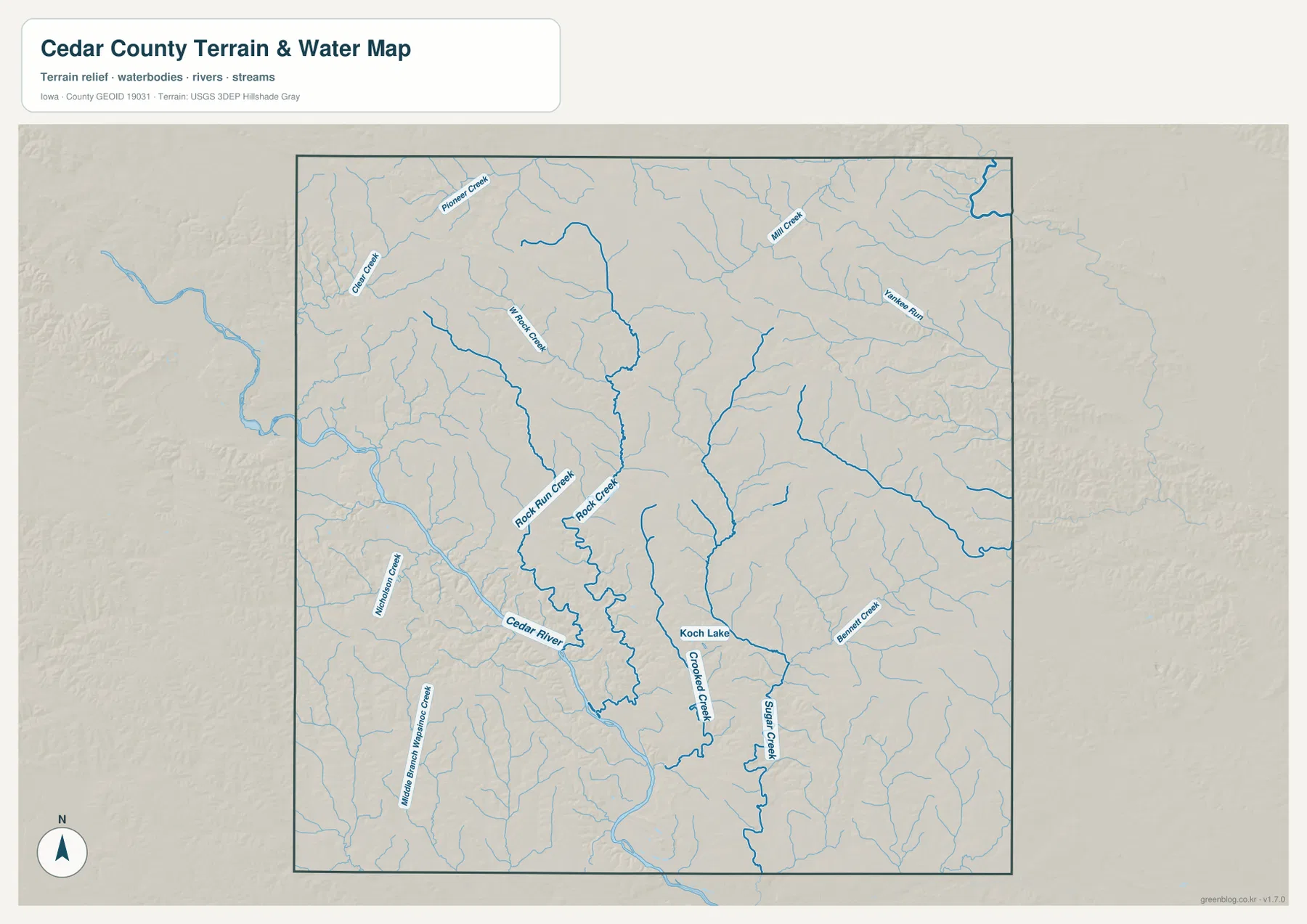
The Cedar River is the most prominent named river on the terrain-and-water map, but it does not dominate the center of the county. Its broader channel and lowland appear mainly along the western and southwestern side. This is important because the county name can create the impression that the river runs directly through the middle of Cedar County. The supplied map instead shows a larger river valley on the southwest side and a much denser pattern of smaller creeks across the interior.
Rock Run Creek and Rock Creek are among the clearest central waterways. They descend through the middle of the county and form winding low corridors that stand out against the surrounding ridges. Koch Lake is labeled farther south near this drainage area, while Crooked Creek continues through the south-central part of the county. East of that area, Bennett Creek and Sugar Creek form additional long drainage lines. Mill Creek and Yankee Run are visible farther north and northeast, adding another set of smaller valleys to the network.
The northwest also contains named smaller streams such as Clear Creek and Pioneer Creek, with Hart Creek closer to the north-central interior. These names make the water map useful for understanding why the terrain is cut into so many narrow ridges and valleys. It should not be used as a flood-zone, legal-water-boundary, water-quality, or navigation map. For those questions, specialized agency data are more appropriate. Here, the purpose is to show where the major and minor drainage corridors sit in relation to the county as a whole.
Elevation ranges from about 192 to 292 meters across ridges and stream corridors
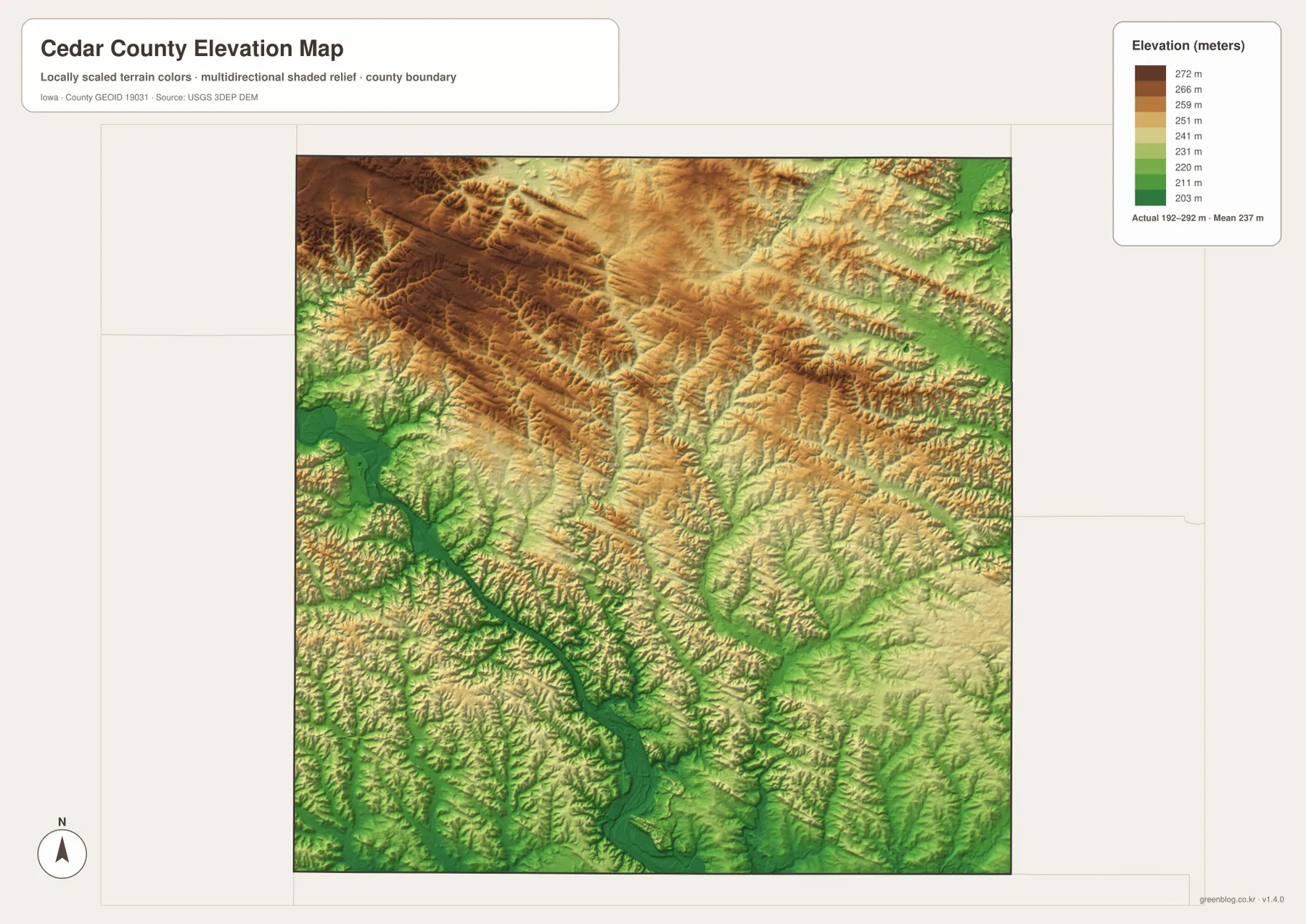
The elevation legend gives an actual Cedar County range of roughly 192 to 292 meters, with a mean near 237 meters. The darkest brown and tan colors are concentrated most strongly in the northwest and across a broad north-central band. This higher ground is not a single smooth plateau. Shaded relief shows many short ridges and narrow cuts, which match the small drainage lines visible on the water map. Looking at the Mechanicsville-Stanwood side of the county first makes the higher northern terrain easier to recognize.
The largest low area is tied to the Cedar River on the western and southwestern side, where green colors form a broad corridor. Smaller green branches extend away from this lowland along creek valleys. Rock Creek and Crooked Creek also correspond with lower south-central paths, while several eastern and southeastern drainages create additional green strips. The surface therefore does not simply slope in one direction. It is a repeated pattern of uplands separated by river and creek valleys.
Some lower terrain also appears toward the northeastern edge, reinforcing the point that high ground in the northwest does not mean every location becomes progressively lower toward the southeast. The map is best used for broad relief comparison: where the higher ridges are, where the larger lowlands lie, and how drainage lines cut through them. Green does not automatically mean wetland or floodplain, and brown does not indicate mountains or development suitability. Site-level elevations for engineering or construction require source elevation data and professional survey work.
A Tipton-to-West Branch and Durant comparison connects roads with terrain
A practical way to read the set is to start at Tipton and move outward. On the general map, locate Tipton with Iowa 38 and Iowa 130, then look north toward U.S. 30 and the Mechanicsville-Stanwood-Clarence-Lowden line. Switching to the elevation map shows that much of this northern area sits on comparatively higher rolling ground. The same sequence gives the road information first and the relief information second, which is easier to interpret than beginning with terrain colors alone.
For the southern half, I-80 provides a second reference. West Branch lies at the southwest side and Durant at the southeast edge, with the Iowa 38 interchange between them. The water map then shows that the west side is influenced by the larger Cedar River valley, while the south-central and eastern side is cut by smaller creeks such as Crooked Creek and Sugar Creek. Two places can both be near I-80 while still sitting in noticeably different drainage and relief settings.
This comparison also explains why Tipton works so well as a county anchor. It is not the largest city by a wide margin, but its central position makes the northern U.S. 30 communities, southern interstate communities, and interior creek valleys easier to organize. If a reader needs a quick county overview, starting in the middle and moving toward the four edges reduces the chance of treating Cedar County as a single road corridor or a single river valley.
Choose the map that matches the question before enlarging or printing
For towns, roads, and boundary orientation, begin with the general county map. It shows more place names than the ranked city map and makes U.S. 30, I-80, Iowa 38, and Iowa 130 easier to compare. The city map is better when the goal is to explain how the six highlighted communities are distributed, especially the contrast between central Tipton, the two southern-edge cities, and the northern group. Using the two together avoids confusing a simplified ranking graphic with a complete community list.
For natural features, find the Cedar River on the water map first, then follow Rock Creek, Crooked Creek, Sugar Creek, and the other named tributaries. After that, switch to the elevation surface to see which valleys correspond to lower green terrain and where the brown ridges rise between them. The water map is not a flood or property-boundary product, and the elevation image is not survey-grade. Keeping those limits in mind makes the maps more useful because each one can be used for the question it was designed to answer.
The WebP images in the article are reduced for fast viewing. The downloadable archive contains the original 3638 × 2572 pixel JPG versions of the general county, city distribution, terrain-and-water, and elevation maps. Those files are more suitable for enlarging labels, printing, or comparing the same county boundary across the different subjects. You can use only the file you need or place them side by side when a road, stream, or ridge is easier to understand across more than one map.
Frequently Asked Questions
What is the quickest way to compare Tipton with West Branch?
Start with the general map. Tipton is near the center, while West Branch is close to the southwestern boundary. From Tipton, Iowa 38 leads south toward I-80; following the interstate west brings you toward West Branch. The city-distribution map then removes much of the extra road detail and makes the central-versus-southwest separation especially easy to see.
Does the Cedar River run through the center of Cedar County?
Not on the supplied terrain-and-water map. The Cedar River is most prominent along the western and southwestern side of the county. The central and eastern interior is instead divided by smaller waterways such as Rock Creek, Crooked Creek, Sugar Creek, and Bennett Creek. The county name is therefore not a reliable guide to the river’s exact position; the water map is the better reference.
Do the brown areas on the elevation map represent mountains?
No. Brown marks the higher parts of Cedar County relative to the rest of the county, and the mapped range is only about 192 to 292 meters. The colors help distinguish northern ridges from the lower Cedar River and creek valleys, but they do not classify mountain terrain, flood risk, or development suitability. Exact site elevations should be checked with source elevation data and a survey when needed.
Map File Information
The original high-resolution JPG files are bundled in one ZIP for closer viewing, printing, and comparison of Cedar County roads, cities, waterways, terrain, and elevation.
- File Type: ZIP containing 4 JPG files
Related Maps
Sources and references
These official resources provide additional county context and the underlying types of boundary, hydrography, and elevation information used for map reference.
- Cedar County, Iowa – About Cedar County
- Cedar County, Iowa – Communities
- Cedar County Conservation
- U.S. Census Bureau TIGER/Line Shapefiles
- USGS National Hydrography
- USGS 3D Elevation Program
Green Map creates custom-edited map images using open geographic data sources such as geoBoundaries, Natural Earth, OpenStreetMap, and government open data.
These maps are edited visual materials, not raw data files, and are provided for education, documents, presentations, and graphic reference.