Little River County in far southwestern Arkansas is centered on Ashdown, with Foreman and Winthrop spread across the western half and Ogden to the south. Much of the county outline follows large river bends, and Millwood Lake occupies a prominent position near the northeastern side. The western interior is noticeably higher and more rolling than the lower ground along the eastern and southern river corridors. This page shows communities, roads, direct city connections, streams, lakes, and an actual elevation range of about 70 to 146 meters. The same four maps are available as high-resolution JPG files in one downloadable ZIP.
Ashdown is the current county seat and the easiest reference point on the general map. County-specific sources note that the Little River and Red River form major parts of Little River County’s boundary, placing Ashdown between two important river systems. On the supplied map, Routes 32 and 71 meet near Ashdown, with Routes 59 and 108 also close by. From that central-eastern point, Foreman lies well to the west, Wilton is just to the north, and Ogden is south along the Route 71 side.
Table of Contents
Roads fan out from Ashdown toward Foreman, Wilton, and the western hills
The general map shows Ashdown where several of the county’s clearest road lines come together. Route 32 runs across the central area, Route 71 continues north and south, and Route 59 leads toward Wilton. Routes 108 and 234 extend west through the interior, while Route 317 appears north of Ashdown near the Millwood Lake side. Rather than memorizing each number separately, it is easier to begin at Ashdown and trace the broad directions toward Wilton, Foreman, and Ogden.
Foreman has its own western road cluster. Route 3 follows the far western side, while Routes 87 and 41 continue toward the lower boundary. Winthrop is farther north, where roads cross a more rolling landscape cut by small creeks. The contrast with the Ashdown-Ogden side is visible even before looking at the elevation map: western roads bend more often, while the lower eastern and southern areas contain longer, simpler road segments.
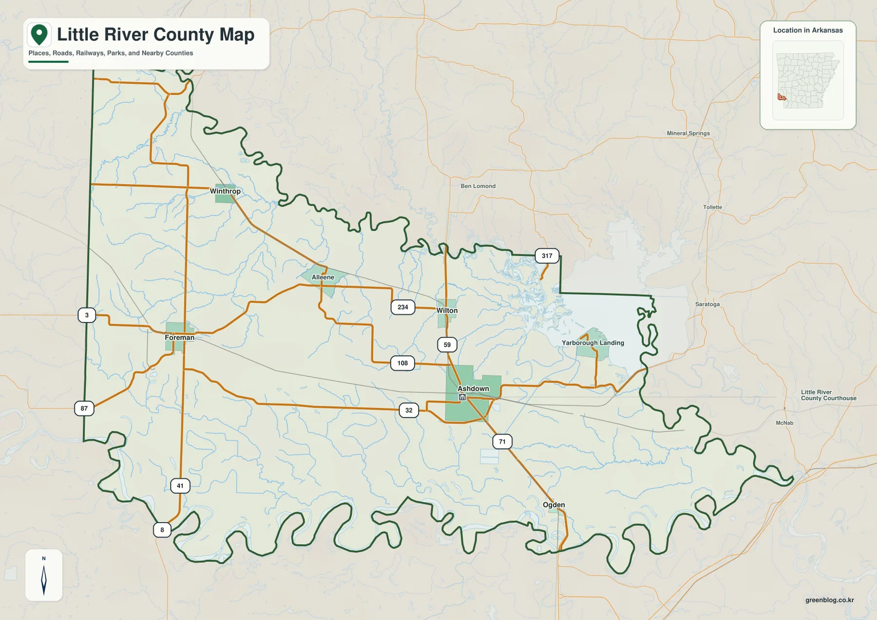
The county outline is unusually irregular because long sections follow rivers rather than straight survey lines. Broad curves repeat along parts of the north, east, and especially the south. The Encyclopedia of Arkansas notes that the Little River and Red River form major portions of the county boundary. Sevier, Howard, Hempstead, and Miller counties provide Arkansas reference points around the map, while Oklahoma and Texas lie close to the western and southern sides of this far-corner county.
The Ashdown hub map gives direct distance to four nearby communities
The city-connections map uses Ashdown as the hub and gives straight-line distances to four other communities. Wilton is about 4 miles away, Ogden about 8 miles, Foreman about 16 miles, and Winthrop about 17 miles. These are point-to-point distances rather than driving mileage. They are useful for comparing direction and county scale, but road distance and travel time should be checked with a current navigation map.
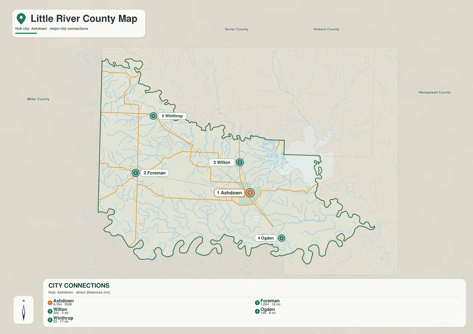
Those distances make the county’s settlement pattern easy to understand. Wilton is very close to Ashdown on the northern side, and Ogden is still relatively near on the southbound corridor. Foreman and Winthrop are much farther across the western half, with Alleene and large rural areas between them and Ashdown. The elevation map also shows that the Foreman-Winthrop side contains more high ground, so the city map is useful for comparing both location and terrain.
The city legend also includes numeric values beside the community names, but this article does not reinterpret those figures as current population estimates. The supplied map clearly supports the hub, directions, and direct distances. Ashdown’s status as the county seat comes from separate county-specific reference information.
Millwood Lake and the Little River system dominate the northeastern water map
Millwood Lake is the largest and most recognizable water feature on the terrain and water map. The reservoir was created by damming the Little River and extends across the corners of several southwestern Arkansas counties. On this map, it occupies the northeastern side of Little River County, with Lick Creek and Mill Creek approaching through lower valleys from the west. For readers starting at Ashdown, the lake is the clearest landmark for understanding the northeastern part of the county.
The western half contains a different network of streams. Caney Creek and Hurricane Creek wind through the higher northwestern terrain, and West Flat Creek crosses the lower Foreman side. Farther east, Mill Creek and Lick Creek occupy long valleys that descend toward the lake and river system. Hudson Creek appears in the southeastern half. The creek pattern becomes easier to understand when the water map is compared directly with the elevation shading.
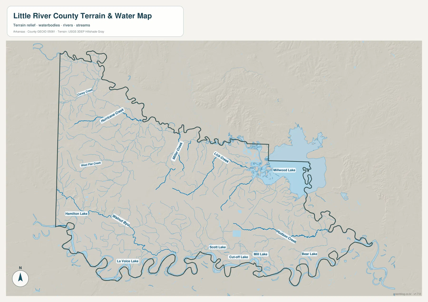
Along the lower boundary, several named lakes and curved water bodies appear close to the river lowland. Hamilton Lake is on the southwestern side, while La Voice Lake, Scott Lake, Cut-off Lake, Mill Lake, and Bear Lake are spread farther east. Walnut Bayou also follows the lower western side. Instead of one single lake dominating the south, the map shows a chain of smaller water features associated with low ground and broad river bends.
The Little River and Red River help shape the county boundary, while Millwood Lake adds another major water feature near Ashdown. This map is intended for general geographic reference. It does not provide current lake or river stage, flood risk, fishing rules, property boundaries, or live road access. For boating, fishing, flooding, or other safety decisions, use current USGS or agency information for the specific waterway.
Elevation rises in the west and falls toward the eastern and southern river lowlands
The supplied elevation map shows an actual countywide range of about 70 to 146 meters, with a mean near 97 meters. That is roughly 76 meters of relief. The highest brown and tan terrain is concentrated in the western interior and around the Foreman side, while the Ashdown-Millwood Lake area and the long southern river edge are mostly lower green terrain. The county is not mountainous, but the west-to-east contrast is strong enough to shape stream valleys and road patterns.
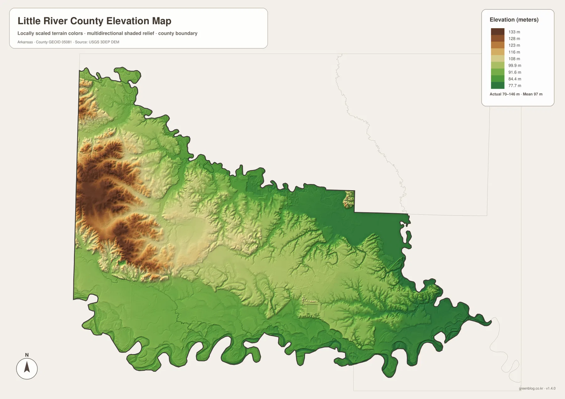
The higher western terrain is made of repeated short ridges rather than one isolated summit. Caney Creek and Hurricane Creek occupy lower corridors between those ridges, and the Foreman side contains several clear valleys. Moving east toward Ashdown, the colors become progressively greener and the terrain opens up. North of Ashdown near Wilton and Millwood Lake, relief is also much gentler than in the western interior.
The southern boundary is generally low, matching the broad river curves and the chain of small lakes shown on the water map. Ogden is also located within this lower southern setting. Little River County is therefore best understood as a transition from rolling western uplands into lower river and reservoir country toward the east and south. The elevation map is intended for county-scale comparison rather than survey-grade measurement; exact parcel, road, bridge, or building elevations require original elevation data or a professional survey.
Compare Foreman and Millwood Lake from Ashdown to see the county change
A practical way to use all four maps is to begin at Ashdown and compare west with northeast. Traveling visually toward Foreman and Winthrop brings more rolling terrain, tighter creek valleys, and longer separation between the major communities. The city-connections map places Foreman and Winthrop about 16 and 17 straight-line miles from Ashdown, reinforcing the scale of the western half. The elevation map shows the same direction becoming steadily higher.
Looking northeast from Ashdown produces the opposite pattern. Millwood Lake becomes the dominant landmark, the terrain stays lower, and Lick Creek and Mill Creek approach the reservoir through broad valleys. South toward Ogden, which is about 8 straight-line miles from Ashdown, the land also remains relatively low and several curved water features lie near the boundary. Wilton is only about 4 straight-line miles north of Ashdown, making it the closest connected community on the supplied city map.
High-resolution JPG files for Ashdown roads and Millwood Lake detail
The WebP images in the article are optimized for quick page viewing. The download ZIP contains the same four maps as high-resolution JPG files, each measuring 3638 × 2572 pixels in landscape orientation. Use the general map for communities and roads, the city-connections map for direct direction and distance from Ashdown, the terrain and water map for Millwood Lake, creeks, and smaller lakes, and the elevation map for comparing the western uplands with eastern and southern lowlands.
The JPG files are suitable for classroom reference, presentations, trip preparation, personal printing, and general orientation. They should not replace legal boundary records, parcel surveys, flood studies, engineering plans, or live navigation. When exact or current information is required, consult Census TIGER/Line boundaries, USGS hydrography, USGS elevation data, and the appropriate local or state source for the specific decision.
Frequently Asked Questions
What is the county seat of Little River County?
Ashdown is the county seat of Little River County. It is also the strongest road center on the supplied general map, with Routes 32, 71, 59, and 108 among the roads nearby. Using Ashdown as a reference makes it easy to locate Wilton, Foreman, Winthrop, Ogden, and Millwood Lake.
What distances are shown from Ashdown to nearby communities?
The city-connections map shows about 4 miles from Ashdown to Wilton, 8 miles to Ogden, 16 miles to Foreman, and 17 miles to Winthrop. These are straight-line distances rather than driving mileage.
Where is the highest terrain in Little River County?
The supplied elevation map places the highest terrain mainly in the western interior and around the Foreman side. The actual countywide range is about 70–146 meters with a mean near 97 meters. The Ashdown, Millwood Lake, and southern river areas are generally lower.
Map File Information
The ZIP contains the general county map, city-connections map, terrain and water map, and elevation map as high-resolution JPG files for printing or offline reference.
- File Type: ZIP containing 4 JPG files
Related Maps
Sources and references
- Encyclopedia of Arkansas – Little River County – county seat, Little River and Red River boundaries, and county background
- Encyclopedia of Arkansas – Ashdown – Ashdown and county-seat information
- Encyclopedia of Arkansas – Millwood Dam and Lake – Millwood Lake and the Little River reservoir
- U.S. Census Bureau TIGER/Line Shapefiles – county boundary and road data
- USGS National Hydrography – rivers, streams, lakes, and hydrography data
- USGS 3D Elevation Program – elevation and terrain data
Green Map creates custom-edited map images using open geographic data sources such as geoBoundaries, Natural Earth, OpenStreetMap, and government open data.
These maps are edited visual materials, not raw data files, and are provided for education, documents, presentations, and graphic reference.