Jackson County in northeastern Arkansas is a mostly lowland county organized around Newport and two major river systems. The White River bends through the western and central side, while the Cache River runs through the broad eastern lowlands. Newport, Diaz, Tuckerman, and Swifton form a north-south chain of communities along the county’s main road corridor, while the southwestern projection contains the only large area of distinctly higher terrain. This page shows communities, roads, rivers, creeks, lakes, and an actual elevation range of about 61 to 249 meters. You can download the same four maps as high-resolution JPG files in one ZIP.
Newport is the best starting point on the general map. Diaz and Campbell Station are immediately to the north, Tuckerman lies farther up the county, and Swifton is near the northern end. Grubbs and Amagon sit to the east, Beedeville is in the southeast, and Weldon appears farther south. Jacksonport is west of Newport near the White River. Once those places are located, the county’s unusual combination of a long eastern lowland and a broad southwestern extension becomes much easier to follow.
Table of Contents
Newport anchors the main road corridor toward Tuckerman and Swifton
The road network is densest around Newport and Diaz. Route 18 crosses the central area through Newport and continues east toward Grubbs, while Route 67 runs north past Tuckerman and Swifton. Route 384 extends east from the Newport side, and Route 224 serves the western and southwestern area. It is easier to understand the county by following these directions out of Newport than by trying to memorize every route number separately.
Tuckerman is connected westward by Route 226 and northward by Route 367 toward Swifton. Route 76 crosses the Swifton area, while Route 67 continues along the eastern side of the northern half. Farther south, Route 14 crosses the Amagon area, and Routes 37, 145, and 42 serve the Beedeville side of the southeastern lowland. These eastern roads are generally straighter and more widely spaced than routes near the higher southwestern projection, matching the much flatter terrain.
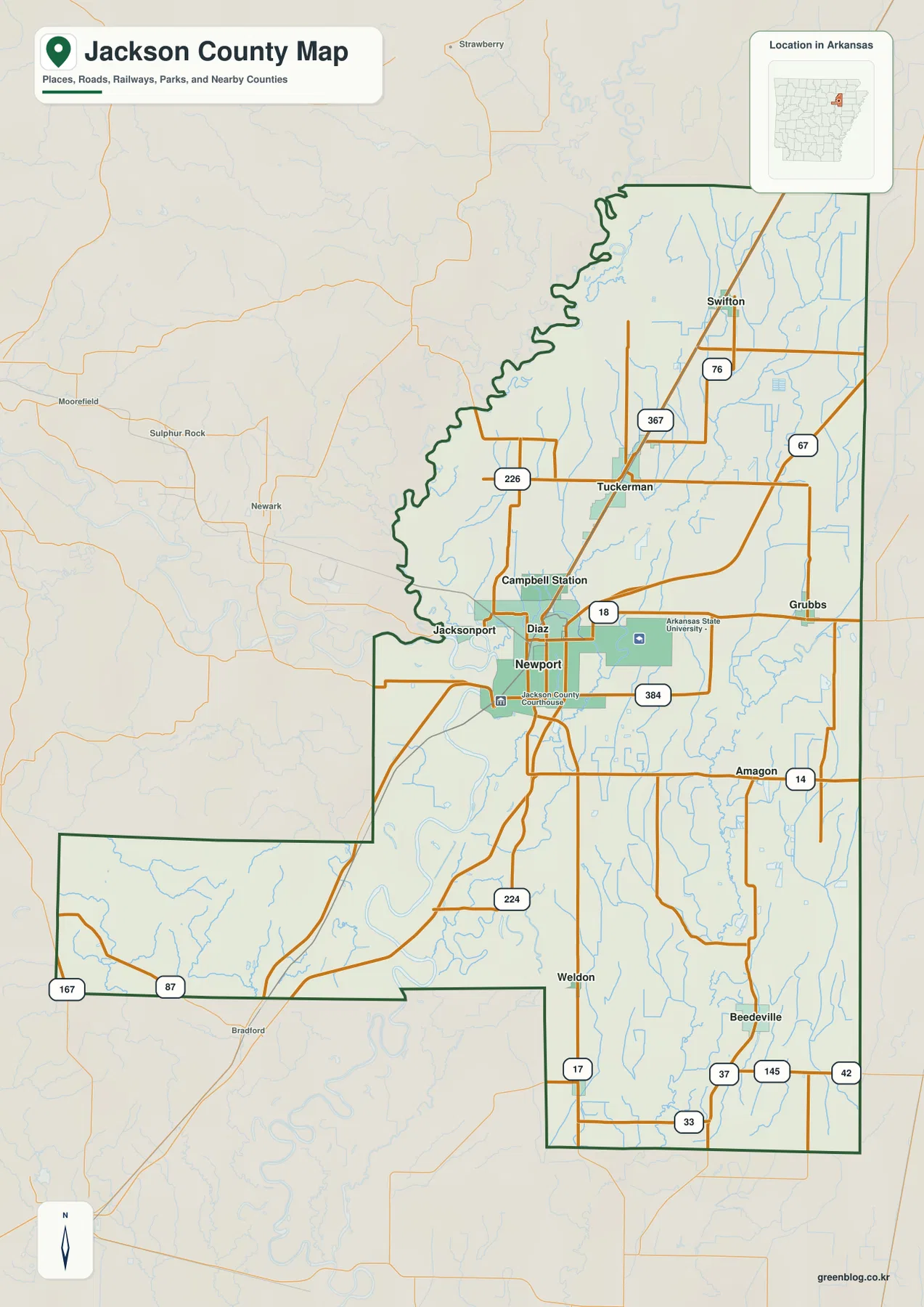
The western boundary is far more irregular than the eastern side. From the north toward the middle of the county, the boundary bends repeatedly through the White River lowland. A broad southwestern projection extends well beyond the main north-south body of the county, and Routes 167 and 87 cross that area. By contrast, much of the eastern boundary runs in long straight segments. The shape of the county therefore mirrors the contrast between winding river country on the west and broad low plains to the east.
The ranked city map emphasizes Newport and a northern chain of communities
The city map ranks six major communities. Newport is number 1, followed by Tuckerman at 2, Diaz at 3, Swifton at 4, Grubbs at 5, and Campbell Station at 6. These numbers are ranking markers, not distance labels. Newport and Diaz are close together in the central area, Tuckerman and Swifton extend northward, Grubbs lies to the east, and Campbell Station is northwest of Newport. The ranking view makes the concentration of communities in the north-central part of the county easy to see.
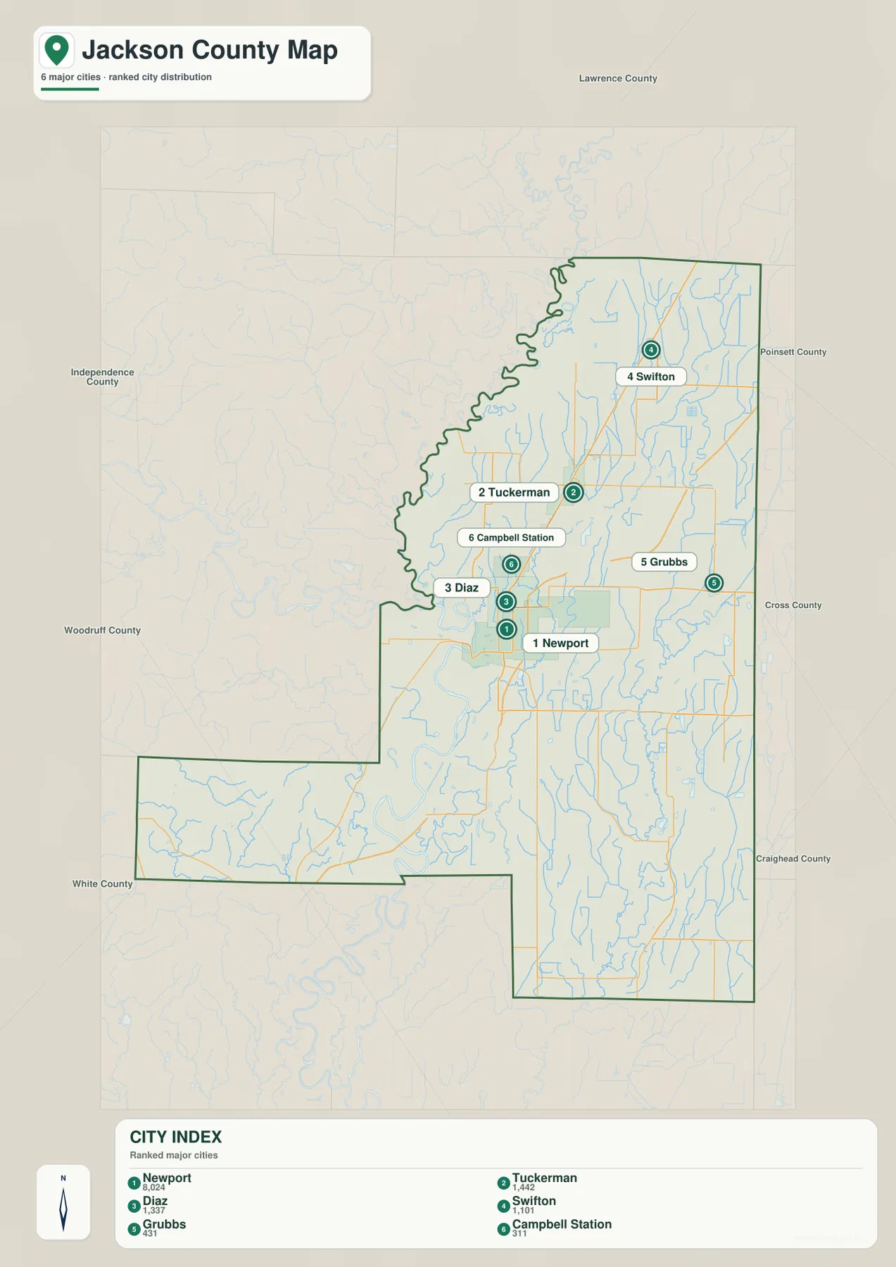
Comparing the city map with the general road map adds useful context. Newport and Diaz sit where several roads meet, Tuckerman and Swifton follow the Route 67 corridor northward, and Grubbs occupies a much flatter eastern setting. Campbell Station is closer to the White River side and the west-central lowland. The city map is therefore most useful as a simplified orientation view before returning to the road and water maps.
The legend also contains numeric values beside the city names, but this article does not reinterpret those figures as current population estimates. The supplied map clearly supports the rank and position of the six communities, so those are the facts used here. Anyone needing current population totals should consult a recent Census source rather than treating a simplified map legend as a current demographic table.
White River and Cache River frame a dense lowland water network
The White River is the dominant water feature on the western and central side of the terrain and water map. It bends through the county near Newport and Jacksonport and continues through broad low country toward the southwestern extension. Eagle Lake, Big Horseshoe Lake, and Pickett Lake are labeled near the White River corridor. Glaise Creek crosses the higher southwestern projection and descends toward the lower river country, making that corner especially useful for comparing terrain and water together.
The Cache River forms another major north-south drainage on the eastern side. Locust Creek and Locust Creek Ditch run through the central-eastern lowland, while Village Creek approaches from the northeast. Farther south, Eight Mile Creek joins the broader Cache River area, and Cow Lake Ditch cuts through the eastern plain. The result is not one simple river valley but a wide network of rivers, creeks, ditches, and small water bodies spread across an unusually flat landscape.
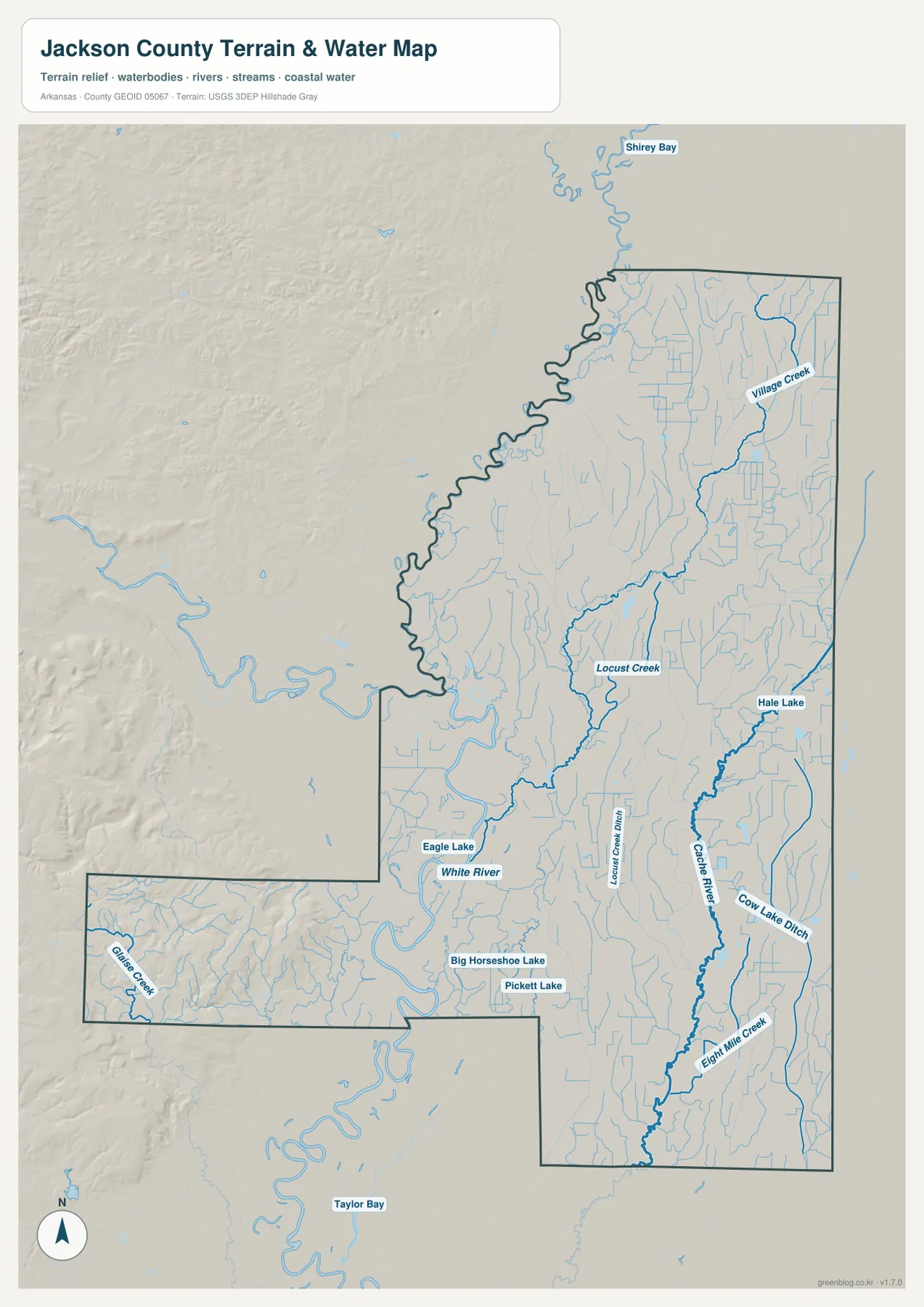
Hale Lake is labeled east of the Cache River, while several smaller curved water bodies appear around the White River side. Shirey Bay is visible outside the county to the north, and Taylor Bay appears farther south as regional context. Jackson County is therefore better understood as river lowland with many secondary channels and lakes than as a county dominated by one large reservoir.
This terrain and water map is intended for general geographic reference. It does not provide current river stage, flood risk, fishing regulations, property boundaries, or live road access. Conditions on the White River and Cache River can change with rainfall and upstream conditions. For recreation, flooding, or other safety decisions, use current information from USGS or the agency responsible for the specific waterway.
Most of the county is low, but the southwestern projection rises above 200 meters
The supplied elevation map shows an actual range of about 61 to 249 meters, with a mean near 78 meters. Most of Jackson County appears in green, indicating broad low terrain with relatively small local elevation changes. The major exception is the southwestern projection, where tan and brown uplands rise sharply above the surrounding plain. The total mapped relief is about 188 meters, but that relief is concentrated in one part of the county rather than spread evenly across the entire area.
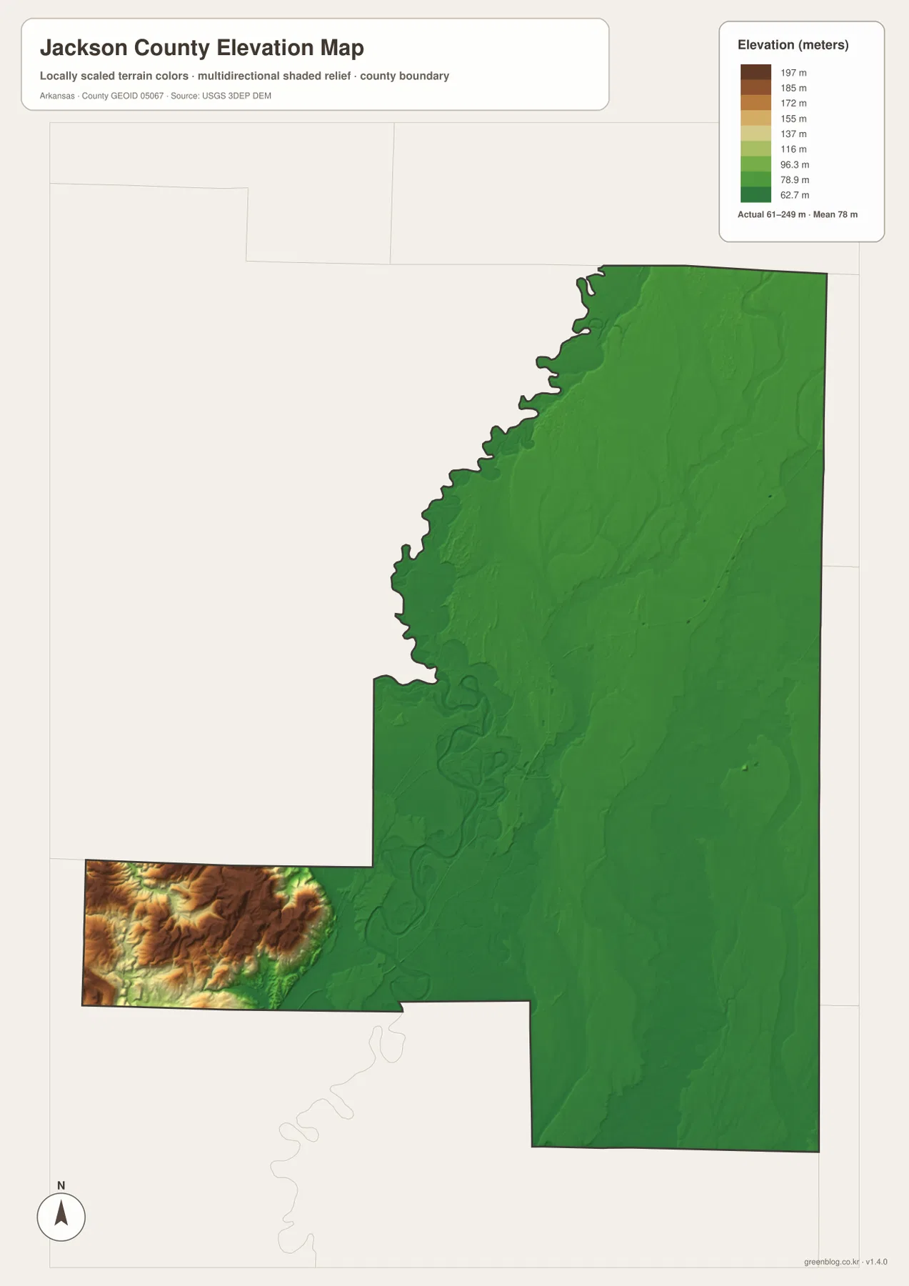
The White River and Cache River sides show very little color variation compared with the southwest. Newport, Tuckerman, Swifton, Grubbs, and most of the main settled corridor all lie in this lower landscape. That helps explain why roads in the eastern and central parts can run in long, relatively straight segments and why the water map contains so many ditches and slow-moving lowland channels. The southwestern corner, by contrast, shows tightly packed ridges and valleys.
Moving east from the high southwestern terrain, the elevation colors change quickly back to green as the land descends toward the White River plain. Glaise Creek and smaller tributaries follow valleys out of that upland block. The elevation image is designed for county-scale comparison rather than survey-grade measurement, so exact parcel, road, bridge, or building elevations require original elevation data or a professional survey.
Compare the White River side with the Cache River plain from Newport
A practical way to use the four maps together is to start at Newport and compare opposite directions. West toward Jacksonport and the White River, large bends, lakes, and secondary channels dominate the landscape. Continuing southwest eventually reaches the much higher upland projection. East toward Grubbs and Amagon, roads cross broad low ground while the Cache River system, drainage ditches, and smaller creeks become more prominent.
Looking north from Newport toward Tuckerman and Swifton provides another useful comparison. Elevation changes very little along this corridor, but the water map shows many small channels and Village Creek farther northeast. South toward Beedeville, the terrain remains low but the road and drainage patterns change again. Switching among the general, water, and elevation views makes these differences easier to understand than trying to read every feature from one map.
High-resolution JPG files for roads, waterways, and elevation detail
The WebP images in the article are optimized for quick page viewing. The download ZIP contains the same four maps as high-resolution JPG files, each measuring 2572 × 3638 pixels in portrait orientation. Use the general map for communities and roads, the city map for the ranked distribution of major places, the terrain and water map for the White River, Cache River, creeks, lakes, and ditches, and the elevation map for comparing the broad lowland with the higher southwestern terrain.
The JPG files are suitable for classroom reference, presentations, trip preparation, personal printing, and general orientation. They should not replace legal boundary records, parcel surveys, flood studies, engineering plans, or live navigation. When exact or current information is required, consult Census TIGER/Line boundaries, USGS hydrography, USGS elevation data, and the appropriate local or state source for the specific decision.
Frequently Asked Questions
Do the numbers 1 through 6 on the city map show distances?
No. They are ranking markers for the six major communities shown on the map. Newport is ranked first, followed by Tuckerman, Diaz, Swifton, Grubbs, and Campbell Station. The numbers do not represent straight-line mileage or driving distance, so actual travel distance and time should be checked with a current road or navigation map.
Where are the White River and Cache River on the Jackson County map?
The White River bends through the western and central side near Newport and Jacksonport, while the Cache River runs through the broad eastern lowland. Locust Creek, Village Creek, Eight Mile Creek, and several ditches connect with the wider lowland drainage between and around the two rivers.
Where is the highest terrain in Jackson County?
The highest terrain on the supplied elevation map is concentrated in the southwestern projection. The actual elevation range is about 61–249 meters with a mean near 78 meters. Most of the county is broad lowland, but the southwest contains tan and brown terrain rising above 200 meters.
Map File Information
The ZIP contains the general county map, ranked city map, terrain and water map, and elevation map as high-resolution JPG files for printing or offline reference.
- File Type: ZIP containing 4 JPG files
Related Maps
Sources and references
- U.S. Census Bureau TIGER/Line Shapefiles – county boundary and road data
- USGS National Hydrography – rivers, streams, lakes, and other hydrography data
- USGS 3D Elevation Program – elevation and terrain data
Green Map creates custom-edited map images using open geographic data sources such as geoBoundaries, Natural Earth, OpenStreetMap, and government open data.
These maps are edited visual materials, not raw data files, and are provided for education, documents, presentations, and graphic reference.