The Suwannee County Florida Land Cover Map is dominated by two broad surface types rather than one overwhelming class. Agriculture accounts for 41.02% of the 2025 summary, followed by forest at 30.56%. Developed land covers 9.76%, grassland 7.01%, wetlands 5.89%, shrubland 4.84%, and open water 0.53%. The county therefore reads as a working and wooded landscape with smaller developed centers and scattered wet areas, not as a mostly urban or mostly wet county.
Four related views are provided here: the 2025 land-cover overview, a forest-and-farmland view, an impervious-surface map, and a 1985–2025 class-difference map. The WebP images are useful for quick comparison in the article, while the four original JPG maps are grouped in one ZIP download below. Each view adds a different piece of the county story, from the balance between farms and forest to the very limited area of concentrated hard surface.
Table of Contents
Agriculture leads the 2025 summary, but forest remains a major part of the county
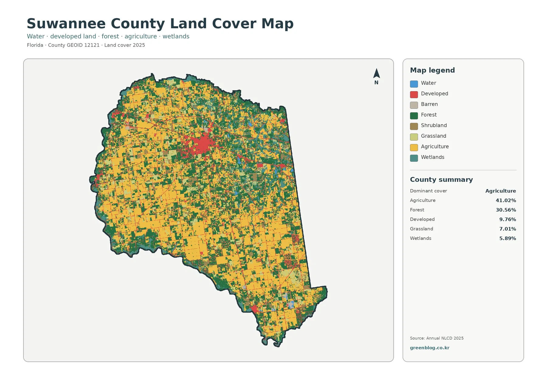
Agricultural cover is especially prominent across the west, southwest, and large parts of the south. Yellow blocks repeat in a field-like pattern, but they are frequently interrupted by dark green forest, pale grassland, and smaller wetland areas. The map does not show one uninterrupted farming district. Instead, working land is broken into many pieces that meet wooded and semi-natural cover throughout the county.
Forest is the second-largest class at 30.56%. Dark green is widespread in the north and east and also appears between farmed areas in the west. The forest is not confined to one corner, so describing Suwannee County as simply “agricultural in the west and forested in the east” would miss much of the mixed pattern. The two dominant classes repeatedly meet along irregular edges and narrow connections.
Developed land represents 9.76% of the county. It is visually noticeable because the strongest red concentration sits near the middle of the map, with thinner developed traces extending outward. Smaller developed areas occur elsewhere, including toward the east and southeast. This is a good example of why visual prominence and total area are not the same: a smaller class can stand out when it is clustered.
Grassland at 7.01% and shrubland at 4.84% fill part of the space between farms, forest, wetlands, and developed land. Wetlands account for 5.89% and are more common in several eastern, northeastern, and southern areas. Open water is only 0.53%. Those categories describe the surface cover assigned to raster cells, not zoning, ownership, property boundaries, or legal development rights.
The vegetation-focused map reveals how closely forest and working land are interwoven
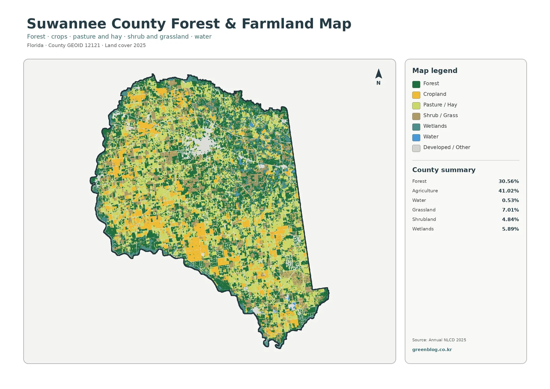
Removing most of the strong developed colors makes the agricultural structure easier to follow. Cropland appears in large yellow blocks, while pasture or hay is shown separately in a lighter green. Both occur throughout the western and southern portions of the county, but they also extend into central and northern areas. Forest repeatedly separates and surrounds those working-land areas, producing a fine-grained mixture rather than a single solid agricultural zone.
The supplied county summary combines the agricultural classes into one 41.02% value. The focused map separates cropland and pasture or hay visually, but it does not provide verified percentages for each category. Estimating exact shares from the colored pixels would create new statistics that are not supported by the package. The appropriate use is to compare their locations and relative visual presence while retaining 41.02% as the verified agriculture total.
UF/IFAS Extension Suwannee County lists agriculture and natural resources among its core areas of service and provides research-based information for county residents. That local context fits a map where working land and forest occupy such large shares. It still does not identify what is grown in a particular colored cell, who owns a farm, or how a field is managed. Those questions require farm records, parcel data, or more detailed local sources.
Forest deserves similar caution. A dark green cell means tree cover is the representative land-cover class for that location. It does not identify a public forest, a conservation easement, a timber tract, or a protected habitat. The 30.56% forest share is useful for county-scale landscape comparison, while ownership and management status belong to a different set of maps and records.
Impervious cover is very low countywide and strongly concentrated
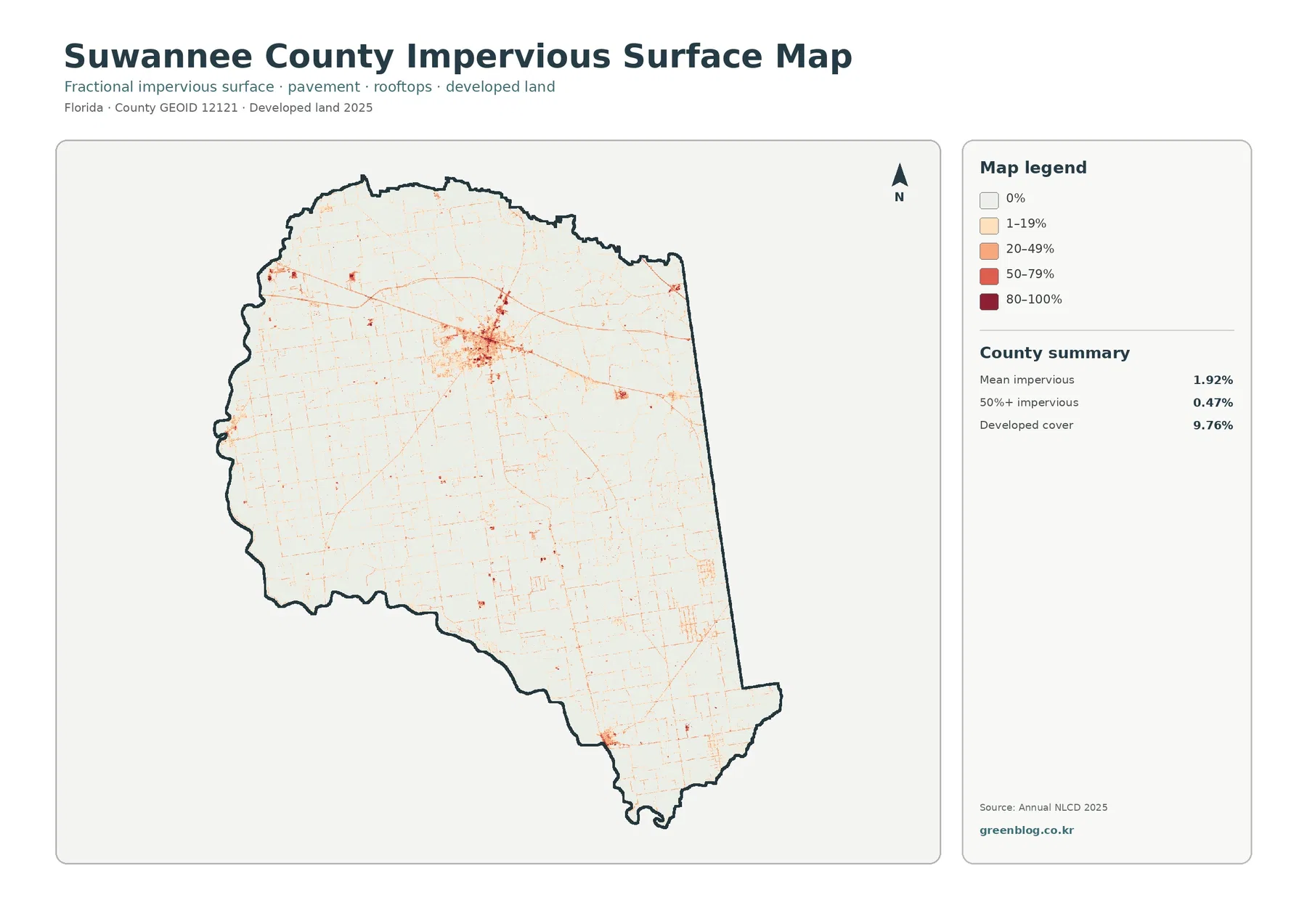
Mean impervious cover is only 1.92%, and 0.47% of the county is mapped at 50% or greater impervious surface. Those figures are far below the 9.76% developed-land share. The difference is expected because a developed land-cover cell can include lawns, trees, bare ground, or other permeable surfaces together with buildings and pavement. Impervious data isolate the fraction occupied by hard materials such as rooftops, roads, and parking areas.
The strongest hard-surface signal is concentrated near the central developed cluster. Thin orange and red traces extend outward, and a few smaller concentrations occur in the east and southeast. Much of the agricultural west and south and the wooded north and east remain almost white. That contrast makes the map useful for explaining that Suwannee County has developed places without having a high countywide level of hard surface.
Some of the narrow lines resemble roads, but this is not a transportation map. Route names, traffic volumes, lane counts, and pavement condition are not part of the supplied data. A low impervious value also should not be treated as a flood-risk measure. Rainfall, soil, elevation, drainage, river stage, wetlands, and groundwater all affect water movement in ways that an impervious-surface layer alone cannot describe.
The Suwannee River Water Management District manages water and related natural resources across north-central Florida and notes that groundwater is central to the region’s water supply. Its water-supply information is useful background in a county where agriculture occupies a large area and irrigation can be an important water use. That resource provides hydrologic context; it does not change the meaning of the land-cover colors or identify conditions beneath individual mapped cells.
The 1985–2025 comparison marks widespread class differences, not a single story of change
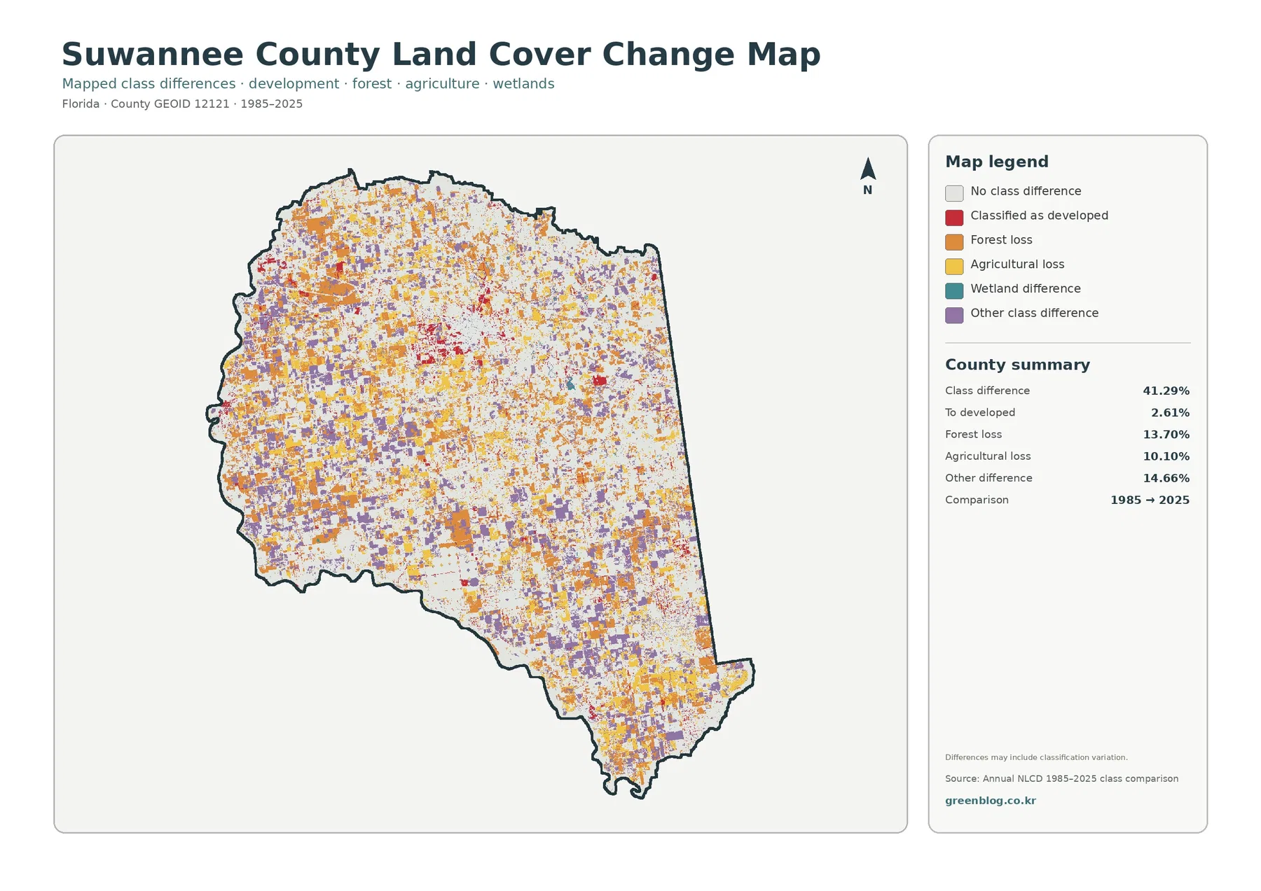
The total class difference between 1985 and 2025 is 41.29%. That does not mean 41.29% of Suwannee County was physically transformed in one simple process. The map compares the class assigned to each cell at two dates. Real land-cover change can contribute, but differences in imagery, classification rules, season, mixed pixels, and other factors may also affect whether a cell receives the same label in both years.
Forest loss is listed at 13.70%, one of the largest highlighted components. Orange cells are widespread in the northwest, west, center, and southeast rather than being limited to one isolated site. The map can identify where a forest classification differs between the two dates, but it does not state why. Timber harvest, agricultural conversion, regrowth cycles, other land conversion, or classification variation would require separate evidence.
Agricultural loss accounts for 10.10%, with yellow difference cells scattered through many of the areas that are currently dominated by agriculture. This value should not be subtracted from the current 41.02% agriculture share to reconstruct a past percentage. One number describes the 2025 surface; the other marks a category of difference between two dates. They measure different things and cannot be combined as if they were parts of one simple balance sheet.
Cells classified as developed account for 2.61% of the comparison, while other class difference is 14.66%. Purple “other” cells are widespread and form a substantial part of the total difference. Wetland difference is included in the legend, but the county summary does not provide a separate wetland-difference percentage. The map can support a location description for that category, not a new percentage estimated by eye.
Frequently Asked Questions
What is the largest 2025 land-cover class in Suwannee County?
Agriculture is the largest class at 41.02%, followed by forest at 30.56%. Developed land is 9.76%, grassland 7.01%, wetlands 5.89%, shrubland 4.84%, and open water 0.53%. Agriculture and forest together account for more than 70% of the supplied 2025 county summary.
Why is developed cover 9.76% while mean impervious cover is only 1.92%?
Developed land can include lawns, trees, yards, and other permeable surfaces along with buildings and pavement. Impervious cover isolates hard surfaces such as rooftops, roads, and parking areas. Because the two measures describe different things, the countywide mean can be much lower than the developed-land share. Only 0.47% of the county is mapped at 50% or greater impervious cover.
Does the 41.29% class difference mean 41.29% of the county was completely transformed?
No. The 41.29% value is the share of cells classified differently in the 1985 and 2025 comparison. Listed components include 2.61% to developed, 13.70% forest loss, 10.10% agricultural loss, and 14.66% other difference. The map warns that classification variation may be included, so specific causes need additional evidence.
Choose the map that matches the question you need to answer
The general 2025 map is the best starting point for a county profile because it combines all major classes in one frame. It makes the 41.02% agriculture share, 30.56% forest share, compact developed areas, and scattered wetlands visible at the same time. A classroom activity can begin by comparing the west and east, then ask where the largest forest blocks occur relative to agricultural land.
For working-land and vegetation topics, the forest-and-farmland map is easier to read. For development intensity, the impervious view isolates hard surface and reduces distraction from the broader developed classification. The change map is most useful after the audience understands the current pattern, because its colors represent differences between dates rather than present-day land-cover classes.
When comparing Suwannee County with another Florida county, use the same observation year and classification system whenever possible. A comparison based on different years can mix geographic differences with changes over time. Mean impervious cover should also be compared with mean impervious cover, rather than with the developed-land percentage, because the two measures describe different aspects of the landscape.
Land cover is not zoning, ownership, or a parcel survey
Land cover describes what physically covers the ground as classified from remotely sensed imagery. Agricultural cover is not a legal agricultural zoning designation, and forest cover does not imply public ownership or protected status. A developed class does not establish that a parcel can be built on, nor does wetland cover establish a regulatory wetland boundary. Legal and property decisions require current parcel, planning, survey, and regulatory information.
Annual NLCD is raster data. The landscape is divided into grid cells, and each cell receives a representative class even though the real ground can contain several surfaces at once. A cell near a field edge might include crops, trees, a drainage ditch, a road, and grass. The map simplifies that mixture so countywide patterns are easier to compare. Small boundaries should therefore be treated as generalized rather than survey-accurate.
The original JPG files in this package are 2480×1754 pixels each. Enlarging them helps with viewing small colored areas, but it does not create new source detail. The asset manifest does not mark these files as meeting the package’s A3 high-resolution reference. They remain useful for screens, presentations, ordinary handouts, and county-scale comparisons, but very large prints should be checked at the intended output size.
Map File Information
This ZIP contains the four original JPG maps used to compare 2025 land cover and related themes across Suwannee County.
- Included Files: 4 original JPG land cover map files shown in this article
- File Type: JPG files in a ZIP archive
- Intended Use: Printing, education, presentations, and map-based projects
Related Maps
- Alachua County Florida Land Cover Map
- Baker County Florida Land Cover Map
- Bay County Florida Land Cover Map
Sources and Reference Data
- MRLC Annual NLCD Data – annual land-cover data used for the 2025 and two-date comparison views.
- USGS Annual NLCD Land Cover Classification – definitions for agricultural, forest, developed, wetland, and other mapped classes.
- U.S. Census Bureau TIGER/Line Shapefiles – official county-boundary reference for Suwannee County.
- UF/IFAS Extension Suwannee County – official local agriculture and natural-resources information.
- Suwannee River Water Management District – Water Supply – official regional groundwater and water-supply context.
Green Map creates custom-edited map images using open geographic data sources such as geoBoundaries, Natural Earth, OpenStreetMap, and government open data.
These maps are edited visual materials, not raw data files, and are provided for education, documents, presentations, and graphic reference.