York County sits in east-central Nebraska, where the City of York anchors a network of smaller communities spread across productive farmland and several creek valleys. This York County Nebraska Map page combines the I-80 and U.S. 81 crossroads with the locations of Henderson, McCool Junction, Bradshaw, Benedict, and Gresham, plus Beaver Creek, Lincoln Creek, West Fork Big Blue River, and an elevation view that shows the county gradually dropping from west to east. The WebP previews are designed for quick viewing, while the same four maps can be downloaded below as high-resolution JPG files in one ZIP archive. High-resolution map files are available for download in the section below.
York and the I-80–U.S. 81 junction are the easiest anchors for reading the county. York is the county seat and the largest city shown. Henderson lies near the southwestern edge, McCool Junction is south of York, Bradshaw is west, Benedict is north, and Gresham is near the northeastern side. The settlement pattern is dispersed across a broad agricultural landscape rather than concentrated in one continuous urban area.
Table of Contents
York at the I-80 and U.S. 81 crossroads
The general county map makes York the dominant transportation reference. U.S. 81 runs north-south through the city, while Interstate 80 crosses the county just south of York. York County Development Corporation describes the intersection of these two major routes as one of the county’s defining location advantages and also identifies U.S. 34 as an important east-west corridor.
Bradshaw sits west of York, Henderson occupies the southwestern side, and McCool Junction lies along the U.S. 81 corridor to the south. Waco is east of York, Benedict is to the north, and Gresham is near the northeastern boundary. The map also shows state-route connections in the northern and eastern parts of the county, creating a road network that spreads outward from York rather than relying on a single corridor.
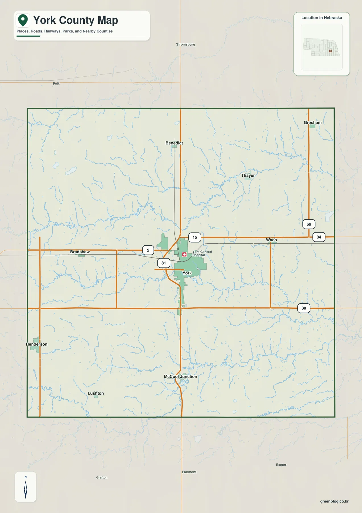
Transportation information from the county development organization notes multiple I-80 exits serving York County, including Henderson, Bradshaw, the U.S. 81/York interchange, and Waco. That helps explain why the southern half of the county has such direct interstate access even though many communities remain small and rural. York itself benefits from both north-south and east-west movement, making it a natural service and logistics center.
This is a regional reference rather than a live navigation product. Construction, detours, and seasonal road conditions can change after a static map is produced. Its strength is orientation: readers can quickly see how York relates to the interstate, how U.S. 81 continues toward McCool Junction, and where the smaller communities sit within the county boundary.
Six ranked communities spread around York
The ranked city map highlights six communities. York is first and clearly dominates the panel, followed by Henderson and McCool Junction. Bradshaw, Benedict, and Gresham complete the list and occupy western, northern, and northeastern positions. The result is a simple picture of a county with one main urban center and several much smaller communities spread across farm country.
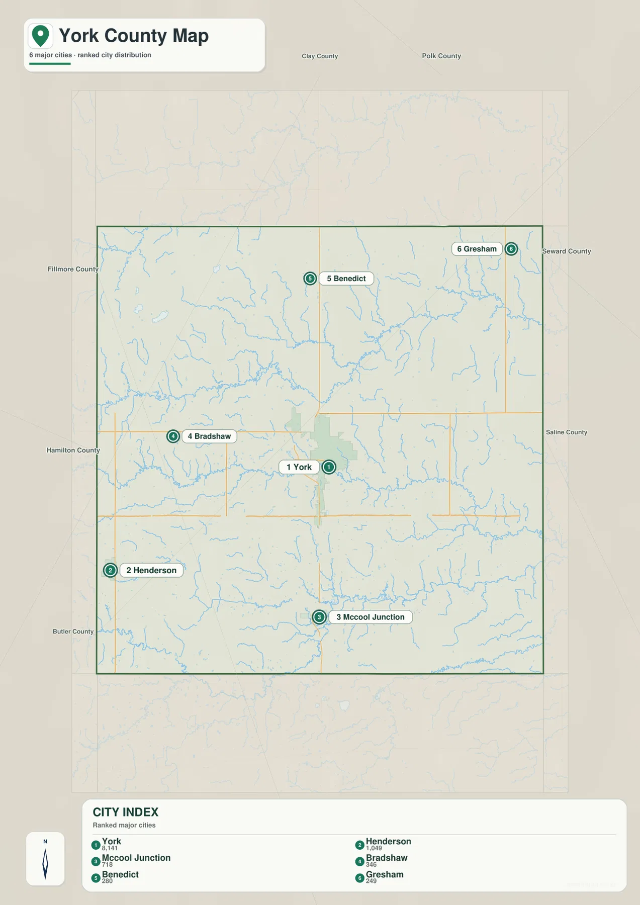
The panel does not contain connector lines or a mileage table between York and the other communities. For that reason, distances should not be invented from the graphic or treated as implied road mileage. Anyone who needs travel distance or driving time should use current route information based on the actual highway and county-road network.
York serves as the county government and service center, while Henderson and McCool Junction create separate southern community anchors near the I-80 and U.S. 81 corridors. Bradshaw and Benedict are smaller farm-country settlements, and Gresham sits close to the Seward County side. Comparing the city panel with the general map helps separate settlement scale from transportation access.
Beaver Creek, Lincoln Creek, and the Big Blue tributary country
Beaver Creek is one of the longest named waterways in the central part of the county. It enters from the west, bends repeatedly across the middle, and collects numerous smaller tributaries along the way. Farther south and east, West Fork Big Blue River forms another major low corridor, with Stone Creek, Antelope Creek, Indian Creek, and other smaller streams feeding the broader drainage system.
Lincoln Creek dominates much of the northern half, with Coon Branch Lincoln Creek entering from the northwest. A short section of the Big Blue River itself appears near the northwestern edge, while Sleepy Hollow Creek is labeled in the east. These waterways show that York County is not organized around one single river; several creek systems divide the agricultural uplands into long, shallow valleys.
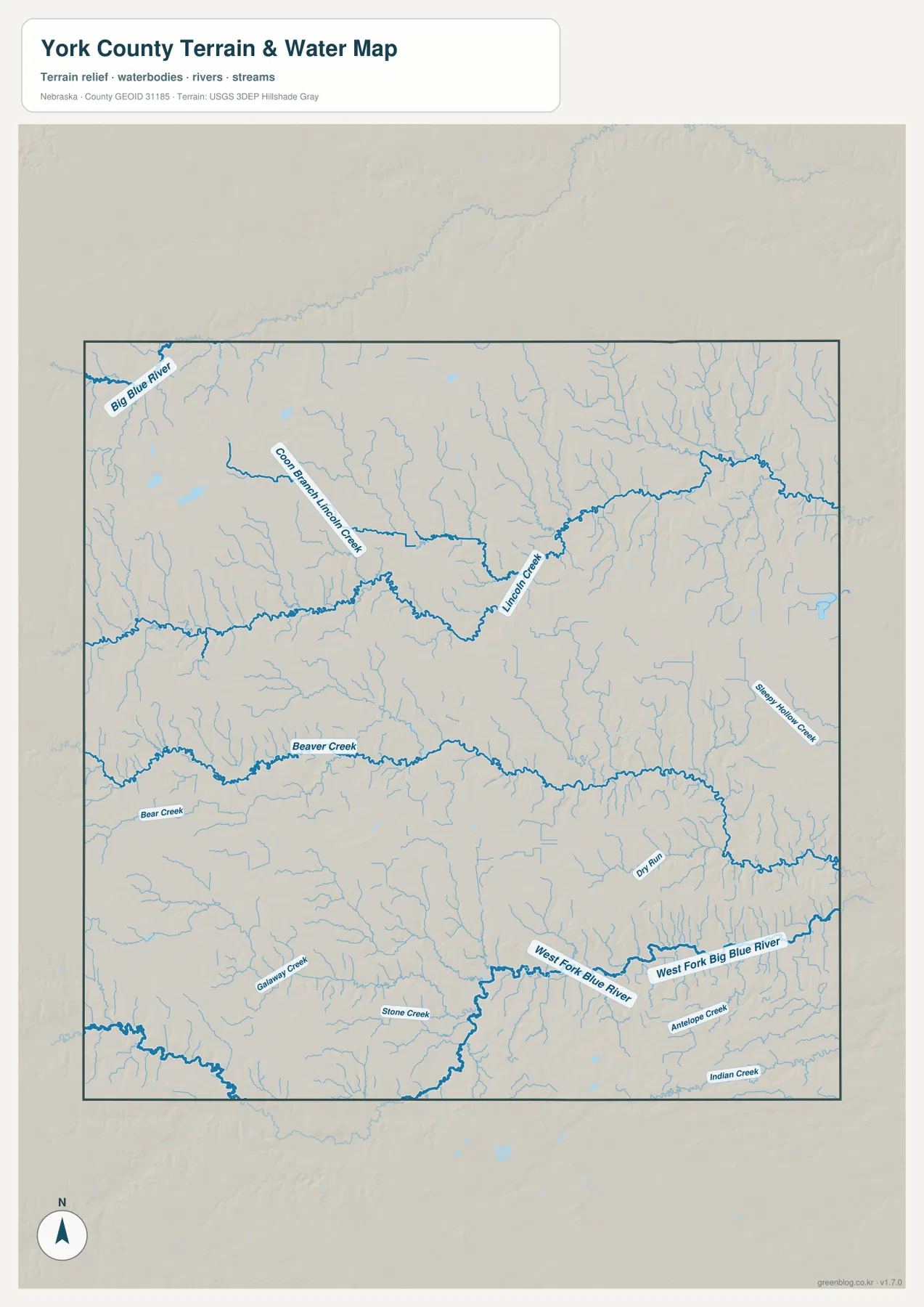
The stream directions also reflect the county’s overall elevation pattern. Beaver Creek and Lincoln Creek occupy lower corridors cut into higher western ground, and many channels trend generally eastward. The West Fork Big Blue River side becomes broader and lower toward the southeast, producing a clear contrast with the higher western and northwestern portions of the county.
Blue line thickness and color should not be interpreted as measurements of discharge, depth, or flood risk. The map is designed to show where streams and channels are located at county scale. Floodplain decisions, water-quality questions, irrigation planning, and safety issues require current information from USGS, FEMA, or the appropriate local and state agencies.
From higher western farmland to lower Big Blue tributary valleys
The elevation map shows a gradual but consistent west-to-east descent. The displayed surface ranges from about 447 to 543 meters, with a mean near 501 meters. Brown and orange are concentrated across the west and northwest, while greens become more common in the east and southeast. The difference is modest compared with mountainous terrain but strong enough to make the major drainage corridors immediately visible.
Lincoln Creek and Beaver Creek cut lower green bands through the western and central uplands. In the southeast, West Fork Big Blue River occupies a broader low corridor, and small tributaries carve branching valleys into the surrounding agricultural surface. The shaded relief makes York County look much more varied than the regular road grid might suggest.
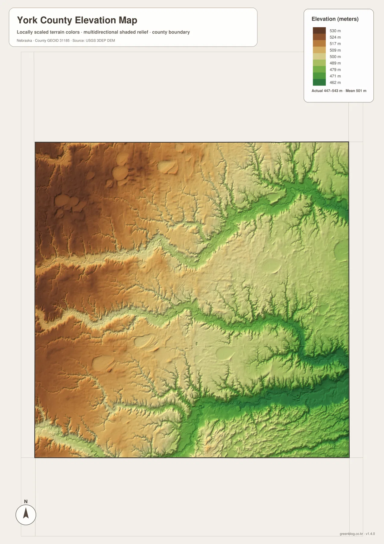
York itself sits on intermediate terrain, while Henderson and the western side generally stand somewhat higher. The Gresham and Waco side is lower and more dissected by creeks. These local elevation differences influence drainage and road alignment even though the county remains primarily agricultural and lacks dramatic mountain or canyon relief.
This elevation surface is intended for county-scale comparison, not parcel surveying or engineering. Exact site elevations, road grades, construction benchmarks, and design values require USGS source data, professional surveying, or another appropriate technical source. Here the image is most useful for comparing western uplands with Beaver Creek and the Big Blue tributary lowlands.
A transportation crossroads beside a living record of Nebraska farm history
The official York County website identifies York as the center of county government and notes that the county takes its name from York, England. Modern regional development information emphasizes a different but equally visible feature: York County sits at the intersection of Interstate 80 and U.S. Highway 81. That combination gives a largely agricultural county unusually direct north-south and east-west highway access.
Just south of York, Wessels Living History Farm adds a distinctive cultural landmark to the same corridor. The farm’s official visitor information places it about one mile south of Interstate 80 on U.S. 81 at Exit 353. It operates as a hands-on living history site focused on Nebraska family farming, with restored buildings, farm equipment, demonstrations, and educational programs.
The farm interprets agricultural life across generations rather than presenting a static collection behind glass. Its historic buildings and demonstrations emphasize how farm work, machinery, irrigation, and family life changed over time. On the county map, the site can be placed regionally by first locating York, I-80, and U.S. 81, although detailed entrance roads and individual farm buildings require the farm’s own visitor information.
A practical order for comparing roads, towns, streams, and relief
Begin with the general county map by locating York at the I-80 and U.S. 81 crossroads, then identify Henderson, McCool Junction, Bradshaw, Benedict, and Gresham. The ranked city map provides a cleaner second view when the goal is simply to compare settlement size and direction without the full road network.
Next, trace Beaver Creek, Lincoln Creek, and West Fork Big Blue River on the water map. The elevation image then shows how those waterways occupy lower corridors between higher western fields. The strongest contrast appears between the warm-colored western uplands and the greener eastern and southeastern drainage country.
High-resolution JPG files are better suited to printing and close inspection when smaller creek names and route numbers matter. These maps remain regional references rather than legal or safety documents. County boundaries can be checked against Census TIGER/Line data, waterways against USGS National Hydrography, and elevation against the USGS 3D Elevation Program.
Frequently Asked Questions
Does the city map show distances from York to Henderson or McCool Junction?
No. The city panel ranks York, Henderson, McCool Junction, Bradshaw, Benedict, and Gresham and shows their positions, but it does not include connector lines or mileage values. Use current route information for actual driving distance and travel time.
Which waterways are most useful for understanding York County?
Beaver Creek is a major central reference, Lincoln Creek and its branches shape the north, and West Fork Big Blue River provides a major low corridor in the south and east. Smaller tributaries further divide the agricultural uplands.
Can the county map be used to visit Wessels Living History Farm?
The general map provides regional context by showing York, Interstate 80, and U.S. 81, which places the farm on the south side of the York corridor. It does not show internal farm roads or visitor facilities, so current directions and hours should come from Wessels Living History Farm.
Map File Information
Download the four high-resolution JPG maps shown on this page for York County in one ZIP archive.
- Included Files: Use only the versions confirmed in the article and supplied images
- File Type: Use the confirmed download contents
- Intended Use: Printing, education, presentations, and map-based projects
Related Maps
Sources and references
County background and government information come from the official York County website. Highway context comes from York County Development Corporation, and agricultural-history background comes from Wessels Living History Farm. The federal sources below provide authoritative references for boundaries, hydrography, and elevation.
- York County, Nebraska – Official Website
- York County Development Corporation – Transportation
- Wessels Living History Farm
- U.S. Census Bureau – TIGER/Line Shapefiles
- USGS – National Hydrography
- USGS – 3D Elevation Program
Green Map creates custom-edited map images using open geographic data sources such as geoBoundaries, Natural Earth, OpenStreetMap, and government open data. These maps are edited visual materials, not raw data files, and are provided for education, documents, presentations, and graphic reference.