Thomas County lies in Nebraska’s central Sandhills, where Thedford serves as the main crossroads and Halsey marks the eastern side of a broad landscape of grass-covered dunes and river valleys. This Thomas County Nebraska Map page combines U.S. 2 and Nebraska 83 with the county’s two ranked communities, the Middle Loup and Dismal rivers, and an elevation view that shows higher western Sandhills dropping toward lower eastern ground. The WebP previews are designed for quick viewing, and the same four maps can be downloaded below as high-resolution JPG files in one ZIP archive. High-resolution map files are available for download in the section below.
Thedford is the easiest place to use as an anchor. U.S. 2 crosses the northern part of the county along the same broad corridor as the Middle Loup River, while Nebraska 83 runs south from the Thedford area through sparsely settled Sandhills. Halsey lies at the eastern edge and Seneca appears to the west. Because the county has few major communities, the relationship among roads, rivers, and relief is more informative than a dense list of towns.
Table of Contents
Thedford at the U.S. 2 and Nebraska 83 crossroads
The general county map makes Thedford the obvious transportation reference. U.S. 2 approaches from Seneca and Norway in the west, passes through Thedford, and continues toward Halsey at the eastern edge. Nebraska 83 crosses the U.S. 2 corridor near Thedford and then runs south through the middle of the county. Those two highways provide a simple frame for reading a county where local roads are otherwise widely spaced.
Halsey sits close to the eastern county line and extends into the neighboring Blaine County area, so the boundary line is important when reading its location. Seneca appears near the western side along U.S. 2. South of the main highway, the road pattern becomes more irregular as routes bend around Sandhills terrain rather than forming a continuous urban street grid.
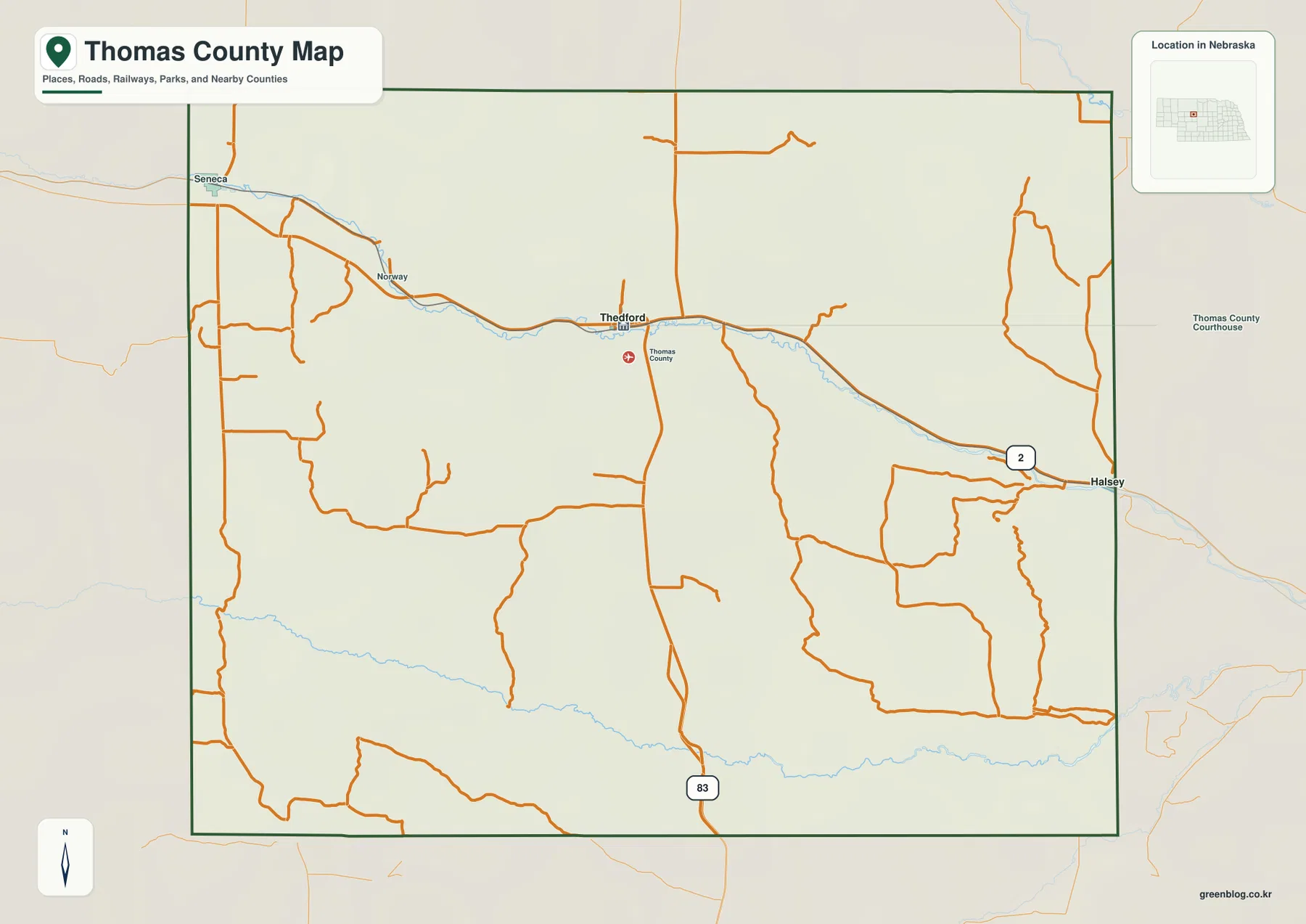
Most of the prominent settlement and highway labels are concentrated in the northern part of the county. The center and south contain long stretches with only local roads crossing grassland and dunes. This contrast is useful because it shows how strongly Thedford and the U.S. 2 corridor function as the county’s main service and travel zone.
The map is a regional reference rather than a live navigation product. Construction, weather, and road conditions can change, so actual travel should be planned with current transportation information. Its main value is orientation: it quickly shows how Thedford relates to Halsey and Seneca and where Nebraska 83 leaves the U.S. 2 corridor for the southern Sandhills.
Two ranked communities along the northern river-and-rail corridor
The ranked city map is deliberately simple. Thedford is listed first and Halsey second, with no other major city markers. Thedford sits in the northern center of the county, while Halsey lies at the eastern edge. Both follow the same broad U.S. 2 and Middle Loup River corridor, emphasizing how settlement is concentrated along the northern transportation route.
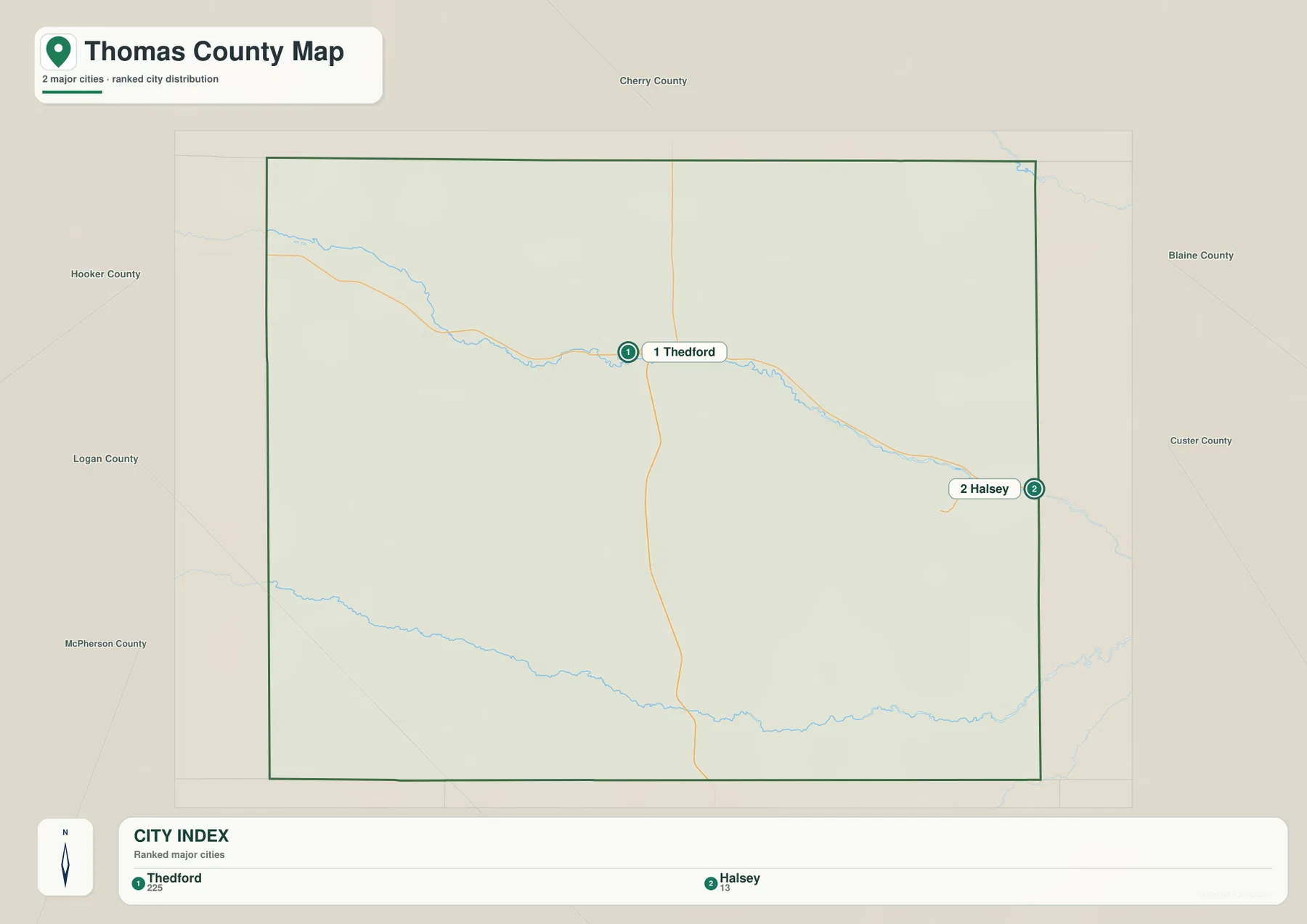
The CITY INDEX provides relative population context, but exact current totals should be checked with the latest Census or local estimates. For geographic reading, the important point is the lack of a dense urban network. Thedford and Halsey serve as two widely separated reference points in a county dominated by ranchland, grass-covered dunes, and river valleys.
History Nebraska records explain that Thomas County was created in 1887 and that Thedford became the county seat when the county was organized. The Burlington and Missouri River Railroad helped establish Thedford and other settlements along the northern corridor, including Seneca and Halsey. The present map still reflects that historic concentration of communities along the route now followed by U.S. 2.
Middle Loup River in the north and Dismal River across the southern Sandhills
The terrain-and-water map is dominated by two long rivers. The Middle Loup River enters from the northwest, bends through the northern part of the county near Thedford, and continues toward Halsey and the east. The Dismal River crosses much farther south, creating a second long valley that is separated from the Middle Loup by a broad expanse of Sandhills.
The Middle Loup corridor broadly parallels U.S. 2 and the county’s main settlement line. Near Thedford, the river and highway remain relatively close before the river bends southeast. The Dismal River follows a more isolated route through the southern ranch country. Its valley is clearly visible even though major towns are absent from that part of the map.
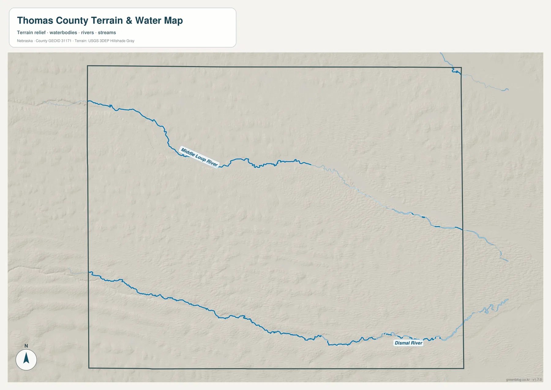
The broad spacing between the two rivers distinguishes Thomas County from eastern Nebraska counties with dense branching stream networks. Small swales and local drainage features occur throughout the dunes, but the two named rivers provide the clearest county-wide structure. The image does not show groundwater levels, wetland boundaries, or current stream conditions.
Blue line thickness and color should not be interpreted as measurements of discharge, depth, or flood risk. Floodplain decisions, land-use restrictions, stream access, and safety questions require current information from FEMA, USGS, and appropriate local agencies. This map is best used to understand where the two river valleys sit within the surrounding Sandhills.
Higher western dunes descend toward the eastern river country
The elevation map shows that Thomas County is far from flat. The displayed surface ranges from about 807 to 1,047 meters, with a mean near 906 meters. Brown and orange dominate much of the west and southwest, where higher dunes and ridges are common. Greens expand toward the east, while the Middle Loup and Dismal rivers form long lower corridors across the county.
The Middle Loup River creates a broad green valley through the northern third. The Dismal River forms another long low band in the south, but the surrounding dunes rise quickly on both sides. Between the rivers, rounded Sandhills repeat across the central county, and the western half generally stands higher than the eastern half.
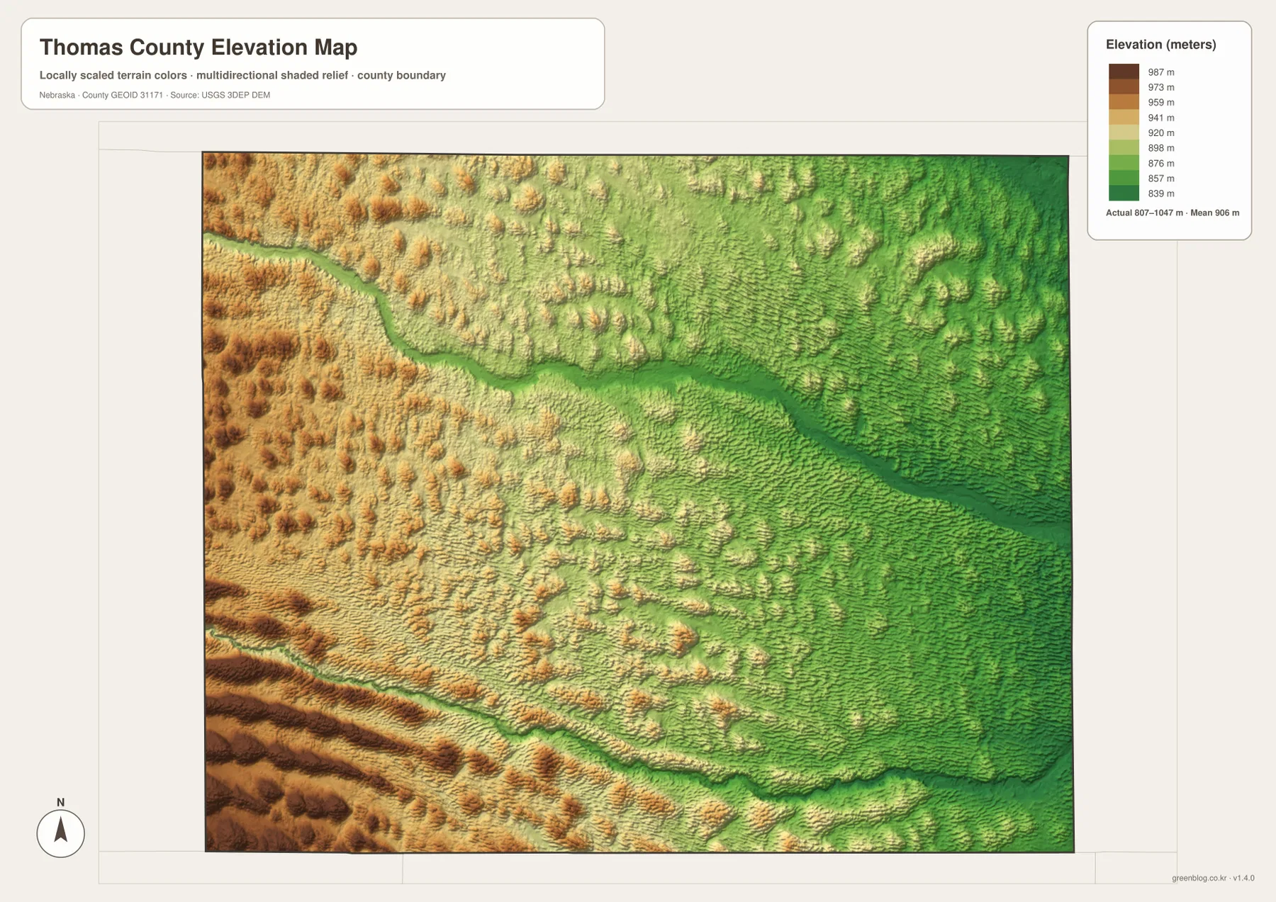
East of Thedford, overall elevation decreases toward Halsey, but the surface remains strongly rolling. The shaded relief reveals repeated dune ridges between small low areas, especially between the two major rivers. This pattern explains why county roads can curve through an otherwise open landscape and why the Sandhills are better understood as grass-covered dunes than as a uniformly level plain.
This elevation surface is intended for county-scale comparison, not parcel surveying or engineering. Exact site elevations, road grades, construction benchmarks, and design values require USGS source data, professional surveying, or another appropriate technical source. Here the image is most useful for comparing the Thedford–Middle Loup corridor, the Dismal River valley, and the higher western dunes.
Thedford county-seat history and the Bessey forest near Halsey
History Nebraska notes that Thomas County was formed in March 1887 and that Thedford became the county seat at organization. Railroad construction through the county in the late 1880s was central to local growth, establishing townsites along the northern corridor. When the Thedford courthouse burned in 1920, Seneca challenged for the county seat, but Thedford retained the role and a new courthouse was built.
Thedford’s modern position at the U.S. 2 and Nebraska 83 crossroads reflects its continuing role as the county’s principal service center. The Nebraska tax equalization record also describes Thedford, Seneca, and Halsey as communities that developed along the railroad line. The historic rail corridor and the present highway-and-river corridor therefore overlap closely in the northern part of the county.
Near Halsey, the Bessey Ranger District adds a very different landscape to the eastern edge of the county. The U.S. Forest Service describes the Bessey area as roughly 90,000 acres of National Forest System land in the Nebraska Sandhills. The district and the Charles E. Bessey Nursery grew from early twentieth-century experiments in planting trees on grass-covered dunes.
The Forest Service’s Bessey Recreation Complex sits near Halsey and provides access to camping and outdoor recreation in the national forest. This county map is not a detailed recreation or trail map, so visitors should use current Forest Service information for roads, campsites, closures, and permits. At county scale, the Halsey label simply provides the geographic link between the Middle Loup corridor and the Bessey forest area.
Using the maps for printing, teaching, and Sandhills comparison
Start with the general county map when you need roads, the boundary, and named communities in one view. Locate Thedford first, follow U.S. 2 toward Halsey and Seneca, and then trace Nebraska 83 south. The ranked city map is cleaner when the goal is simply to show the positions of Thedford and Halsey without the full road network.
Use the water map to compare the Middle Loup River in the north with the Dismal River in the south. The elevation map then shows how both rivers occupy lower valleys inside a much more rolling Sandhills surface. In a classroom, students can mark the two communities, trace the rivers, and then compare western and eastern elevation colors to see the county’s overall descent.
High-resolution JPG files are more useful than the WebP previews when printing or zooming in on small road labels. These maps remain regional references rather than legal or safety documents. County boundaries can be checked against Census TIGER/Line data, waterways against USGS National Hydrography, and elevation against the USGS 3D Elevation Program.
Frequently Asked Questions
Which map is easiest for comparing Thedford and Halsey?
The ranked city map is the simplest choice because it highlights only the two major communities. Thedford is in the northern center and Halsey is near the eastern boundary. Use the general county map when U.S. 2, Nebraska 83, Seneca, and local roads also matter.
Where do the Middle Loup and Dismal rivers cross Thomas County?
The Middle Loup River crosses the northern part of the county near Thedford and continues toward Halsey, while the Dismal River crosses much farther south. A broad area of Sandhills separates the two valleys.
Can the elevation map be used for surveying or construction design?
No. It is designed to compare higher Sandhills with lower river valleys at county scale. Exact site elevations, road grades, and engineering benchmarks require appropriate USGS source data or professional surveying.
Map File Information
Download the four high-resolution JPG maps shown on this page for Thomas County in one ZIP archive.
- Included Files: Use only the versions confirmed in the article and supplied images
- File Type: Use the confirmed download contents
- Intended Use: Printing, education, presentations, and map-based projects
Related Maps
Sources and references
County creation, railroad settlement, and Thedford county-seat history come from History Nebraska. Bessey and Halsey background comes from the U.S. Forest Service, while the federal sources below provide authoritative references for boundaries, hydrography, and elevation.
- History Nebraska – Thomas County Records and Historical Note
- U.S. Forest Service – Nebraska National Forests and Grasslands
- U.S. Forest Service – Bessey Recreation Complex
- U.S. Census Bureau – TIGER/Line Shapefiles
- USGS – National Hydrography
- USGS – 3D Elevation Program
Green Map creates custom-edited map images using open geographic data sources such as geoBoundaries, Natural Earth, OpenStreetMap, and government open data. These maps are edited visual materials, not raw data files, and are provided for education, documents, presentations, and graphic reference.