Stanton County lies in northeastern Nebraska, where the City of Stanton and the village of Pilger anchor a largely rural county cut by the Elkhorn River and many smaller creeks. This Stanton County Nebraska Map page combines the main road network, the relative position of the two major communities, the Elkhorn River and nearby lakes, and an elevation view that contrasts the low river bottomlands with higher hills to the northwest and south. The WebP previews are designed for quick viewing, while the same four maps can be downloaded below as high-resolution JPG files in one ZIP archive. High-resolution map files are available for download in the section below.
Stanton and the Elkhorn River are the easiest features to use as anchors. Stanton sits near the center of the county close to the river, while Pilger is farther northeast near U.S. 275 and Nebraska 15. The official county site identifies Stanton as the county seat and places Wayne County to the north, Cuming County to the east, Colfax and Platte counties to the south, and Madison County to the west. Those neighboring counties help explain the orientation labels around the map.
Table of Contents
Stanton and Pilger on different parts of the county road network
The general county map makes Stanton the central reference point and Pilger the main northeastern community. U.S. 275 crosses the northern part of Stanton County and passes through Pilger, while Stanton lies farther south near Nebraska 24 and Nebraska 57. Nebraska 32 follows the southern part of the county from west to east, and Nebraska 15 runs south from the Pilger area along the eastern side.
Nebraska 35 appears near the northwestern edge, while small place labels such as Woodland Park and Spurville help orient the upper part of the county. Around Stanton, roads bend more noticeably as they approach the Elkhorn River and its low valley. Around Pilger, the east-west U.S. 275 corridor and the north-south route network are more obvious, giving the two communities different transportation settings even within the same county.
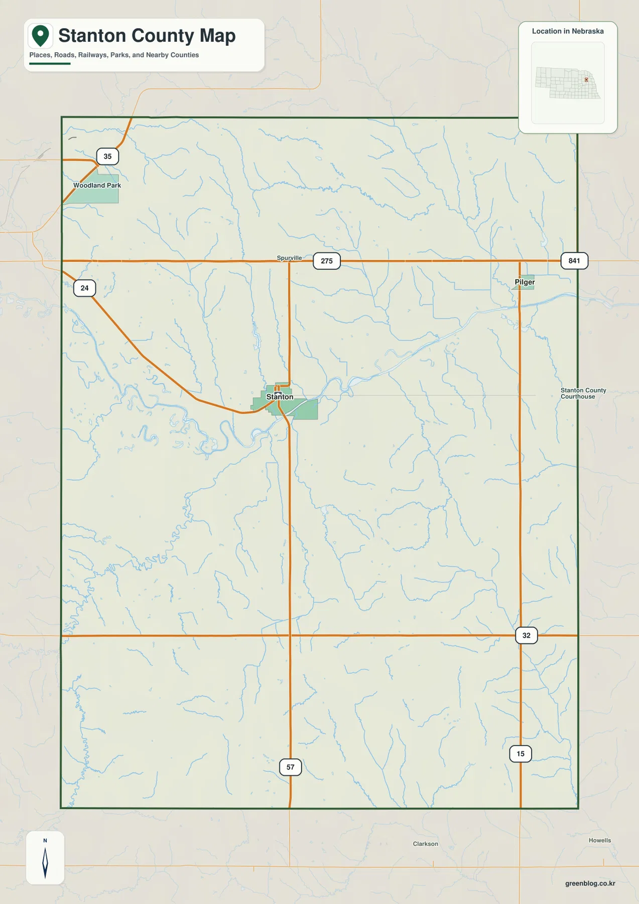
The official Stanton County About page describes a land area of about 432 square miles and lists Stanton and Pilger as the county’s towns. That fits the map’s simple settlement pattern. Stanton serves as the administrative and population center, while Pilger provides the clearest reference point in the northeast. Finding those two places first makes the smaller road and creek labels much easier to organize.
This map is a regional reference rather than a live navigation product. Construction, closures, and seasonal road conditions can change, so actual travel should be planned with current transportation information. Its main value is geographic orientation: it shows how U.S. 275 relates to Pilger, where Nebraska 57 reaches Stanton, and how the southern road network connects with the rest of the county.
A two-community pattern centered on Stanton and Pilger
The ranked city map simplifies Stanton County to its two major communities. Stanton is ranked first and appears near the center of the county, while Pilger is ranked second in the northeast. Their separation is easy to see because there are no other large communities competing for visual attention. The result is a very clear map of how population is divided between a central county-seat community and a smaller northeastern village.
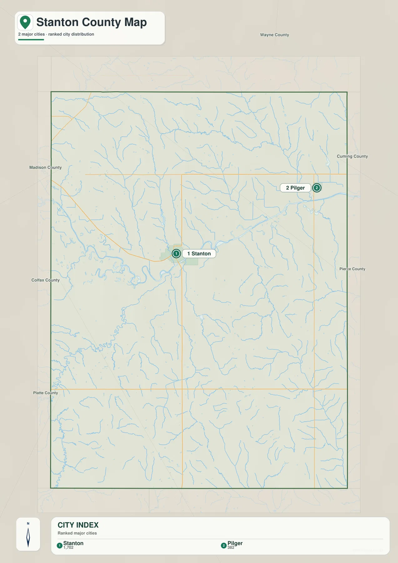
The ranking panel provides relative population context, but exact current totals should come from the latest Census or county records. The official county page reports a 2020 population of 5,842, including 1,520 in Stanton and 240 in Pilger. For map reading, the stronger point is spatial: Stanton occupies a central position near the Elkhorn River, while Pilger lies closer to the Wayne and Cuming county sides.
Neighboring county labels add another useful layer. Madison County lies to the west, Wayne County to the north, Cuming County to the east, and Colfax and Platte counties to the south. Stanton’s position near the middle makes it a convenient reference for the entire county, while Pilger helps orient the northeastern corner. Together the two towns provide a simple framework for reading a landscape that otherwise contains many rural roads and drainage lines.
The Elkhorn River and a dense network of tributary valleys
The Elkhorn River dominates the water map. It enters from the west, bends through the central part of the county just south of Stanton, and continues toward the northeast. A broad low valley follows the river, and numerous smaller creeks drain into it from both sides. Stanton County’s official history also describes bottomlands concentrated along the Elkhorn and its major tributaries.
South Branch Humbug Creek crosses the northern part of the county, while Maskenthine Creek descends toward the center. Sand Creek joins the Elkhorn near the Stanton area, and Cedar Creek appears farther southeast. Union Creek and Meridian Creek provide additional reference points in the south and southwest. The many thin channels show that the county’s rolling uplands are cut by numerous narrow valleys rather than forming one uninterrupted plain.
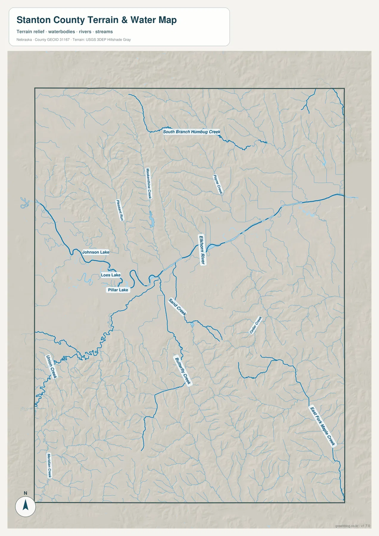
Johnson Lake, Loes Lake, and Pillar Lake are labeled close to the western and central river corridor. These names are useful for orientation, but the map does not provide current water level, water quality, access, fishing, or boating status. Anyone planning recreation should check the responsible local agency for current rules and conditions.
Blue line width and color should not be treated as measurements of discharge, depth, or flood danger. Floodplain decisions, property restrictions, and stream-access questions require current official sources such as FEMA, USGS, and the appropriate natural-resources district. For general geography, the map is most useful for showing how the Elkhorn River organizes the center of the county and how tributaries cut into the surrounding hills.
Elkhorn bottomlands below higher northwestern and southern hills
The elevation map makes the county’s relief much easier to see. The displayed surface ranges from roughly 423 to 567 meters, with a mean near 486 meters. Dark green follows the low Elkhorn River corridor through the middle of the county, while warmer yellow, orange, and brown colors cover higher ground to the northwest and across much of the south.
The northwestern corner contains a dense pattern of ridges and short creek valleys, and elevation drops quickly toward the Elkhorn lowland. South of the river, numerous tributaries cut into higher rolling ground, leaving a patchwork of narrow green channels between tan and brown hills. The southwest and south show some of the strongest warm colors, creating a clear contrast with the broad river bottom near Stanton.
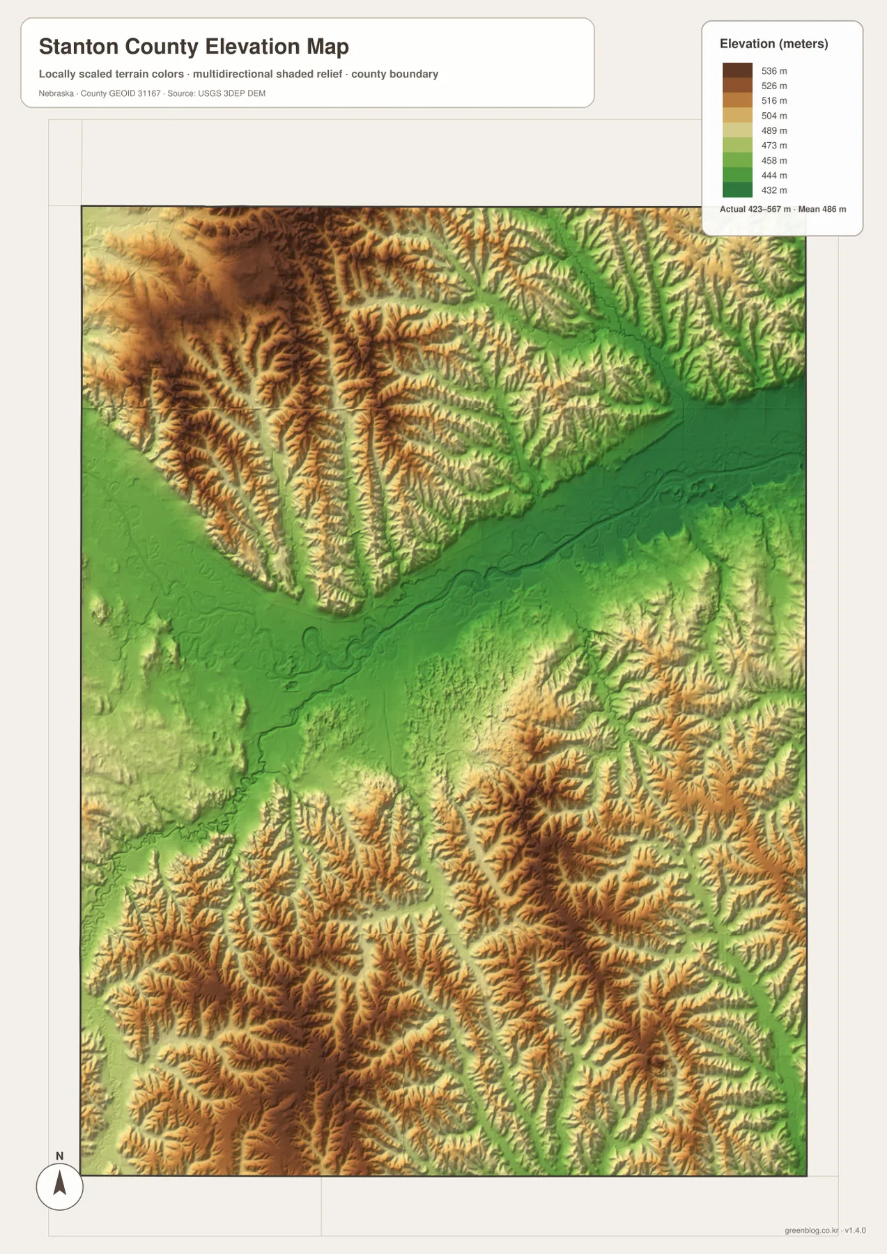
Comparing the water and elevation maps shows how closely the low green corridors match the Elkhorn River and major tributaries. The higher areas generally occupy the land between drainage lines. This relationship also explains why some roads bend as they approach the river or cross creek valleys instead of following a perfectly straight grid.
This elevation surface is intended for county-scale comparison, not parcel surveying or engineering. Exact site elevations, road grades, building benchmarks, and design values require USGS source elevation data, professional surveying, or another appropriate technical source. Here the image is best used to compare the central river bottom with the higher northwestern and southern uplands.
From Izard County to Stanton County and the growth of the Elkhorn Valley
The official county history says the area was once known as Izard County and was renamed Stanton in 1862 for Edwin M. Stanton, who served as Secretary of War under President Abraham Lincoln. The name later became attached to both the county and its principal town. On a modern map, Stanton remains the most prominent place name and the administrative center.
History Nebraska describes the Elkhorn River as one of the features that attracted settlers to the fertile region. Stanton was platted in 1870, and Pilger followed after railroad development, with the village platted in 1880. Those settlement histories fit the current geography: Stanton grew near the river bottomlands, while Pilger sits along the northern U.S. 275 corridor.
County history materials also describe extensive loess uplands suited to agriculture, bottomlands along the Elkhorn and its tributaries, and small sandhills areas south and southeast of Stanton. The modern elevation map reflects much of that variation, with low river land surrounded by rolling uplands. Agriculture remains one of the clearest visual contexts for the county, but the terrain is far from uniformly flat.
Choosing the best map for printing, classes, and local reference
Start with the general county map when you need roads, communities, the boundary, and nearby places in one view. Locate Stanton first, then follow the road network north and east toward Pilger and U.S. 275. The ranked city map is cleaner when the goal is simply to compare the two major communities without the full road detail.
Use the water map to trace the Elkhorn River and tributaries such as South Branch Humbug Creek, Maskenthine Creek, and Sand Creek. The elevation map then shows how those waterways occupy lower corridors within higher rolling terrain. In a classroom, students can identify Stanton and Pilger, trace the river, and then compare the same area on the elevation image.
High-resolution JPG files are more useful than the WebP previews when printing or zooming in on small creek names and road labels. These maps remain regional references rather than legal or safety documents. County boundaries can be checked against Census TIGER/Line data, waterways against USGS National Hydrography, and elevation against the USGS 3D Elevation Program.
Frequently Asked Questions
Which map is easiest for comparing Stanton and Pilger?
The ranked city map is the simplest choice because it highlights only the two major communities. Stanton sits near the center of the county, while Pilger is farther northeast. Use the general county map when U.S. 275 and Nebraska routes 24, 57, and 15 also matter.
Where does the Elkhorn River cross Stanton County?
The Elkhorn River enters from the west, bends through the central part of the county just south of Stanton, and continues toward the northeast. Sand Creek, Maskenthine Creek, and several other tributaries join the river, and Johnson, Loes, and Pillar lakes are labeled nearby.
Can the elevation map be used for surveying or construction design?
No. It is intended to compare low Elkhorn River bottomlands with higher surrounding hills at county scale. Exact site elevations, road grades, and engineering benchmarks require appropriate USGS source data or professional surveying.
Map File Information
Download the four high-resolution JPG maps shown on this page for Stanton County in one ZIP archive.
- Included Files: Use only the versions confirmed in the article and supplied images
- File Type: Use the confirmed download contents
- Intended Use: Printing, education, presentations, and map-based projects
Related Maps
Sources and references
County-seat, population, area, history, and Elkhorn Valley background come from the official Stanton County website and History Nebraska. The federal sources below provide authoritative references for county boundaries, hydrography, and elevation data.
- Stanton County – About
- Stanton County – County History
- History Nebraska – Stanton County
- U.S. Census Bureau – TIGER/Line Shapefiles
- USGS – National Hydrography
- USGS – 3D Elevation Program
Green Map creates custom-edited map images using open geographic data sources such as geoBoundaries, Natural Earth, OpenStreetMap, and government open data. These maps are edited visual materials, not raw data files, and are provided for education, documents, presentations, and graphic reference.