Sherman County lies in central Nebraska, where Loup City serves as the main reference point and Ashton, Rockville, Hazard, and Litchfield are spread across a broad rural landscape. This Sherman County Nebraska Map page combines the county road network, major community locations, the Middle Loup River, Sherman Reservoir, named tributaries, and an elevation view that contrasts the low river corridor with higher surrounding hills. The WebP images are for quick viewing, while the same map set is available below as high-resolution JPG files in one ZIP archive. High-resolution map files are available for download in the section below.
Loup City is the easiest place to use as an anchor. Ashton lies to the east, Rockville to the southeast, and Hazard and Litchfield to the southwest. The Middle Loup River crosses the county near the central corridor, while Sherman Reservoir forms a large body of water northeast of Loup City. The official Sherman County government website confirms that the county courthouse is in Loup City, reinforcing its role as the administrative center.
Table of Contents
Roads radiating from Loup City toward Ashton, Rockville, and Hazard
The general county map makes Loup City the most obvious road junction. A north-south route reaches the city from the northern half of the county, while 790th Road comes in from the west. East of Loup City, the road continues toward Ashton, where Nebraska 92 provides a major east-west connection. Southbound routes split toward Rockville and Hazard, so the county seat works well as a geographic starting point for the entire map.
Rockville lies in the southeast near Nebraska 58, while Hazard sits in the southwest near Nebraska 10 and U.S. 2. Litchfield is farther west near the county boundary. Routes 82, 86, and 68 appear across the southern half, linking rural areas that are more widely spaced than the road network around Loup City. The contrast between the northern county seat area and the southern communities is easy to see even before the water and elevation maps are consulted.
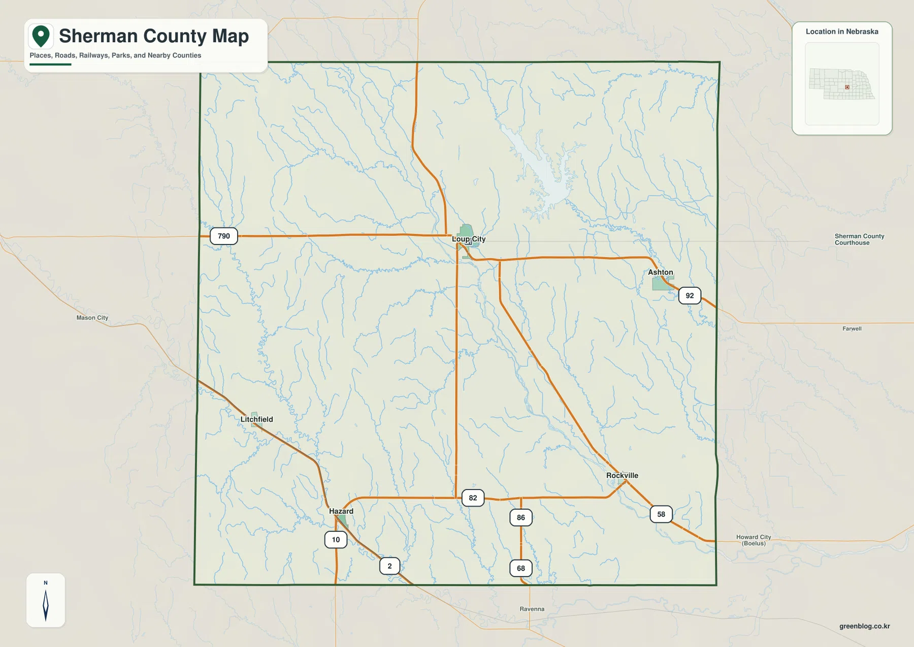
Nearby labels such as Mason City, Farwell, Howard City, and Ravenna help orient the county within central Nebraska, but the dark county boundary should be used to distinguish places inside Sherman County from communities beyond it. This is a regional reference rather than a live navigation product, so road construction, closures, and seasonal conditions should be checked with current transportation sources before travel.
For geographic orientation, the map is especially useful for questions such as which direction Ashton lies from Loup City, how Rockville relates to Hazard, or where the southern roads leave the county. Those relationships remain clear even without the turn-by-turn detail of a navigation service.
Straight-line connections from Loup City to four surrounding communities
The city-connections map simplifies Sherman County to Loup City, Ashton, Litchfield, Rockville, and Hazard. Loup City appears as the hub, with Ashton east of it, Rockville southeast, Hazard southwest, and Litchfield farther west. Removing most secondary road detail makes the relative spacing of the communities much easier to understand.
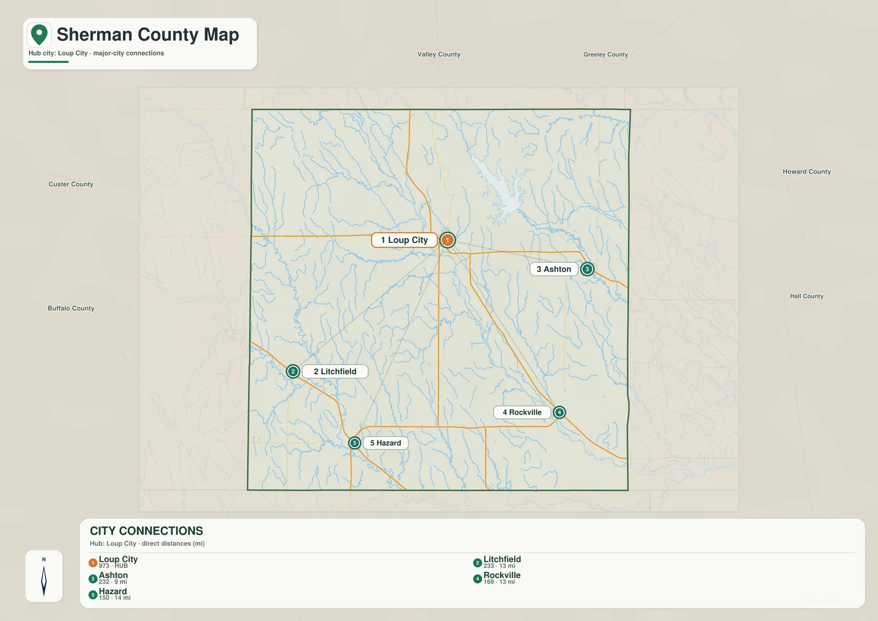
The CITY CONNECTIONS panel reports approximately 22.9 miles from Loup City to Ashton, 23.3 miles to Litchfield, 16.9 miles to Rockville, and 15.0 miles to Hazard. These are direct straight-line distances between mapped points, not driving distances along actual roads. A road trip may be longer because routes bend, bridges limit where waterways can be crossed, and local roads do not always follow the shortest geometric line.
The map is therefore best used to compare direction and general spacing. When paired with the general county map, it becomes easier to see not only which communities are closest to Loup City but also which road corridors connect them and how the Middle Loup River sits within the same landscape.
Middle Loup River, Sherman Reservoir, and a dense network of creeks
The Middle Loup River is the dominant natural watercourse on the supplied terrain-and-water map. It enters from the west and crosses the central part of the county near the Loup City area. Cob Creek and Brown Creek join the central drainage, while Cole Creek and Clear Creek are labeled farther west. Mud Creek and Bloody Run Creek form longer tributary corridors through the southwest.
Sherman Reservoir is the largest body of water on the map and lies northeast of Loup City. Nebraska Game and Parks Commission describes Sherman Reservoir State Recreation Area as a major water-based recreation destination with more than 2,800 acres of water. That information gives useful context, but this county map is not a current park-status, water-level, or boating-access map.
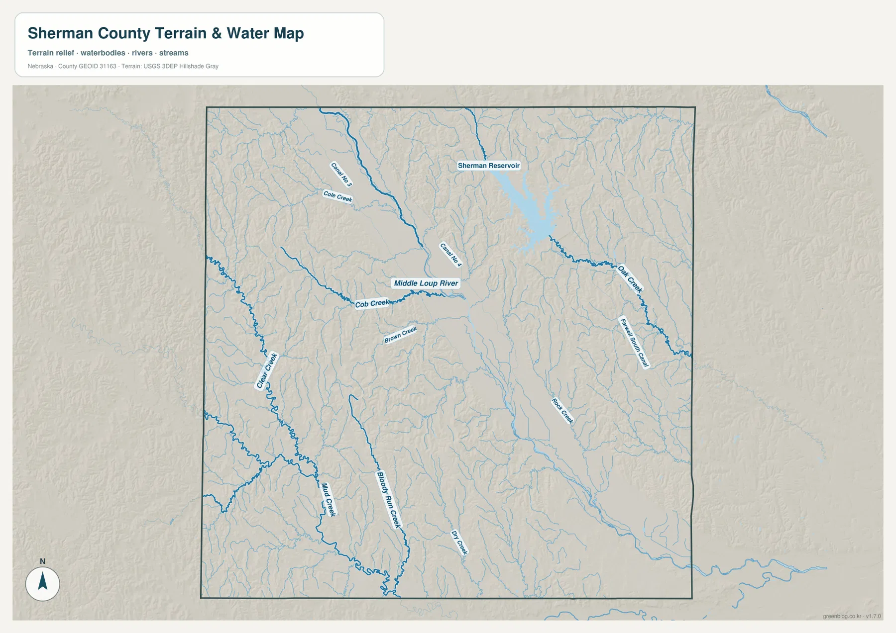
Oak Creek is labeled east of the reservoir, while Rock Creek and the Farwell West Canal appear farther southeast. Smaller channels are spread across the northern and central uplands as well. The map shows where these features are located, but line width and color should not be treated as measurements of discharge or depth.
Floodplain decisions, stream access, reservoir levels, and recreation conditions require current information from FEMA, USGS, Nebraska Game and Parks, or other responsible agencies. For county geography, however, the map provides a clear way to compare the Middle Loup River, Sherman Reservoir, and the creek systems that drain the surrounding hills.
The low river corridor between higher western and northwestern hills
The elevation image shows an actual surface range of roughly 586 to 747 meters, with a mean near 659 meters. A broad green lowland crosses the county diagonally through the central river corridor, while warmer tan and brown colors mark higher ground on both sides. The western and northwestern portions contain some of the most extensive higher terrain visible on the map.
Small tributary valleys cut deeply into the uplands, especially west of the main river corridor. Clear Creek and Mud Creek occupy lower channels through that terrain, while the central Middle Loup Valley remains much broader than most side valleys. In the northeast, repeated ridges and narrow drainages create a strongly textured surface even where elevation is lower than the highest western hills.
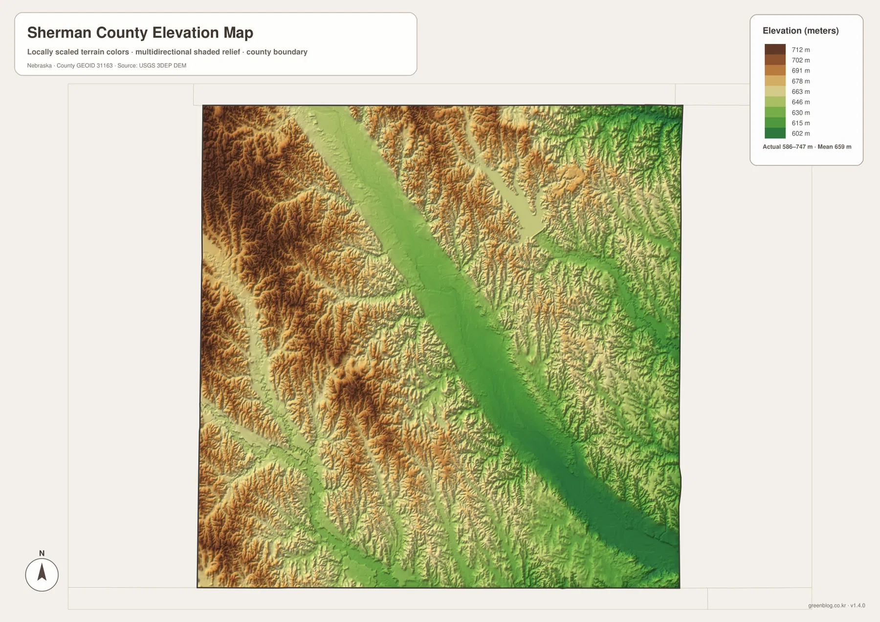
Comparing the water and elevation maps makes the relationship straightforward: the larger rivers and creeks generally occupy lower corridors, while the land between them rises into rolling uplands. The contrast is especially clear around the broad central valley and the tributary-cut hills to the west.
This elevation surface is intended for county-scale comparison rather than parcel surveying or engineering. Exact site elevations, road grades, construction benchmarks, and design values require USGS source elevation data, professional surveying, or another appropriate technical source.
Loup City, county organization, and the later role of Sherman Reservoir
History Nebraska records that Sherman County’s boundaries were defined in 1871 and that the county was formally organized in 1873. Early settlement took place in the Middle Loup Valley near present-day Loup City, which became the county seat when the county was organized. The county was named for General William Tecumseh Sherman.
That history matches the modern map surprisingly well. Loup City still occupies a central position near the Middle Loup River and remains the location of the Sherman County Courthouse. The river valley that attracted early settlement is also the easiest physical feature to follow across the county today.
Sherman Reservoir later became another important county landmark. Nebraska Game and Parks manages recreation at the reservoir, including fishing, boating, camping, and other outdoor uses. On the map, the large water body northeast of Loup City provides a second major landmark alongside the Middle Loup River, making the county easy to recognize from its combination of river valley and reservoir.
Using the maps for printing, teaching, and regional reference
Start with the general county map when you need roads, settlements, the boundary, and nearby place labels in one view. Find Loup City first, then compare Ashton to the east, Rockville to the southeast, and Hazard and Litchfield to the southwest. The city-connections map is cleaner when the goal is to compare direction and straight-line distance from the county seat.
Use the water map when the Middle Loup River, Sherman Reservoir, and named tributaries are the main subject. The elevation image then shows how those waterways occupy low corridors between higher hills. In a classroom, students can locate the five communities first, trace the Middle Loup River next, and then identify the same valley as a green lowland on the elevation map.
High-resolution JPG files are better suited to printing and close inspection when small creek names and road labels matter. These maps remain regional references rather than legal or safety documents. County boundaries can be checked against Census TIGER/Line data, waterways against USGS National Hydrography, and elevation against the USGS 3D Elevation Program.
Frequently Asked Questions
Which map is easiest for comparing Loup City, Ashton, and Rockville?
The city-connections map is the simplest choice because it removes most road detail and shows direction and direct distance from Loup City. Ashton is east of the hub and Rockville is southeast. Use the general county map when road numbers and Hazard or Litchfield also matter.
Where can I see Sherman Reservoir and the Middle Loup River?
The terrain-and-water map shows both most clearly. The Middle Loup River crosses the central county, while Sherman Reservoir lies northeast of Loup City. Oak Creek, Clear Creek, Mud Creek, and several other tributaries are labeled on the same image.
Can the elevation map be used for surveying or construction design?
No. It is designed to compare the low river and creek valleys with higher rolling terrain at county scale. Exact site elevations, road grades, and engineering benchmarks require appropriate USGS source data or professional surveying.
Map File Information
Download the four high-resolution JPG maps shown on this page for Sherman County in one ZIP archive.
- Included Files: Use only the versions confirmed in the article and supplied images
- File Type: Use the confirmed download contents
- Intended Use: Printing, education, presentations, and map-based projects
Related Maps
Sources and references
County government and courthouse information comes from the official Sherman County website. County organization and naming history comes from History Nebraska, while current reservoir recreation information comes from Nebraska Game and Parks. Federal sources below provide authoritative references for boundaries, hydrography, and elevation.
- Sherman County – Official Website
- History Nebraska – Sherman County Records and Historical Note
- Nebraska Game and Parks – Sherman Reservoir
- U.S. Census Bureau – TIGER/Line Shapefiles
- USGS – National Hydrography
- USGS – 3D Elevation Program
Green Map creates custom-edited map images using open geographic data sources such as geoBoundaries, Natural Earth, OpenStreetMap, and government open data. These maps are edited visual materials, not raw data files, and are provided for education, documents, presentations, and graphic reference.