Sheridan County spans a large part of northwestern Nebraska where Pine Ridge country in the north gives way to the Sandhills across the south. This Sheridan County Nebraska Map page shows Gordon, Rushville, Hay Springs, and Clinton; U.S. 20 and the long north-south state highways; the Niobrara River, tributary creeks, and Sandhills lakes; and the elevation contrast between deeply cut northern ridges, the central river valley, and rolling dunes farther south. High-resolution JPG versions of all supplied maps can be downloaded below in one ZIP archive. High-resolution map files are available for download in the section below.
The county is easiest to understand by starting with U.S. 20. Gordon, Rushville, and Hay Springs all sit along or close to that northern east-west corridor, while Clinton is tucked between Gordon and Rushville slightly farther north. Rushville is the county seat, although Gordon is the largest incorporated community in the county’s 2020 figures. South of those towns, settlement becomes much sparser and the map opens into a broad Sandhills landscape crossed by long highways and scattered lakes.
Table of Contents
U.S. 20 links the county’s northern towns
The general map gives U.S. 20 a clear organizing role. It crosses the northern part of Sheridan County through the Hay Springs and Rushville area and continues east toward Gordon. Nebraska 250 leaves Rushville and runs far south through the county, while Nebraska 27 provides another long north-south route on the eastern side. Nebraska 87 serves the western side below Hay Springs, creating several ways to travel between the populated north and the much more open southern half.
Rushville carries the county-seat role, but Gordon is shown as the largest community. The county’s official website reports 2020 populations of 1,504 for Gordon, 816 for Rushville, 599 for Hay Springs, and 38 for Clinton. Those are Census-era figures rather than live estimates, so they should not be treated as current population counts, but they match the relative visual emphasis of the community labels on the supplied maps.
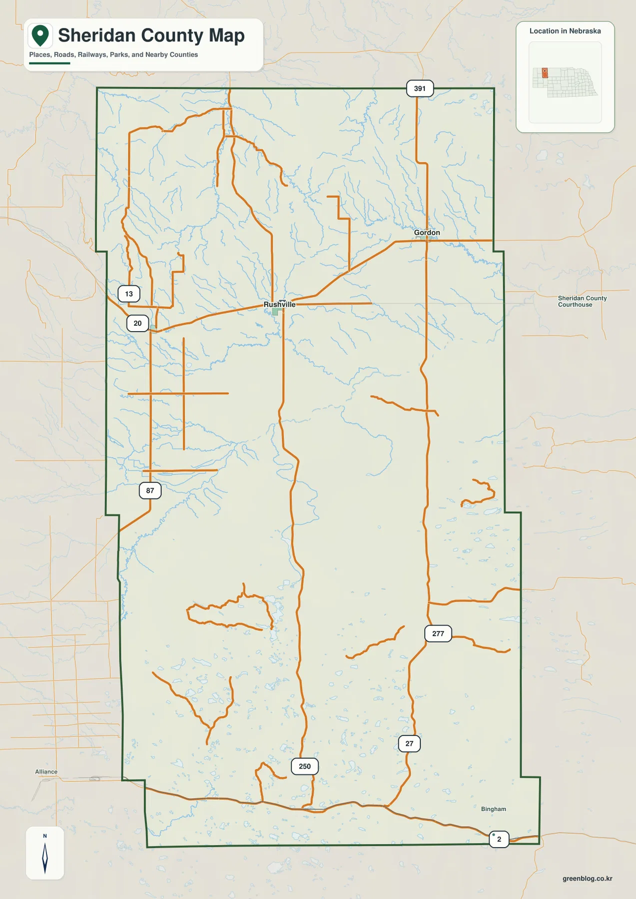
The county changes character quickly south of the U.S. 20 corridor. Town labels become uncommon, while long roads and clusters of small lakes begin to dominate the map. Sheridan County tourism describes the northern and central landscape as part of Pine Ridge country and the southern section as Nebraska Sandhills. It specifically highlights Highways 250, 27, and 87 as routes that move between those two landscapes.
Places labeled outside the dark county boundary, including Alliance to the west and Bingham toward the southeast, are useful regional reference points rather than Sheridan County communities. The road map is also static, so it should not replace live navigation or current road-condition information. Its main value is showing how the northern town corridor connects with the extensive rural interior.
Gordon as the hub for Rushville, Hay Springs, and Clinton
The city-connections graphic uses Gordon as its hub and gives direct distances to three other incorporated communities. Rushville is shown about 15 miles from Gordon, Hay Springs about 26 miles away, and Clinton about 8 miles away. These are straight-line distances between points rather than road-driving distances, so actual trips can be longer once highway alignment, intersections, and local access are taken into account.
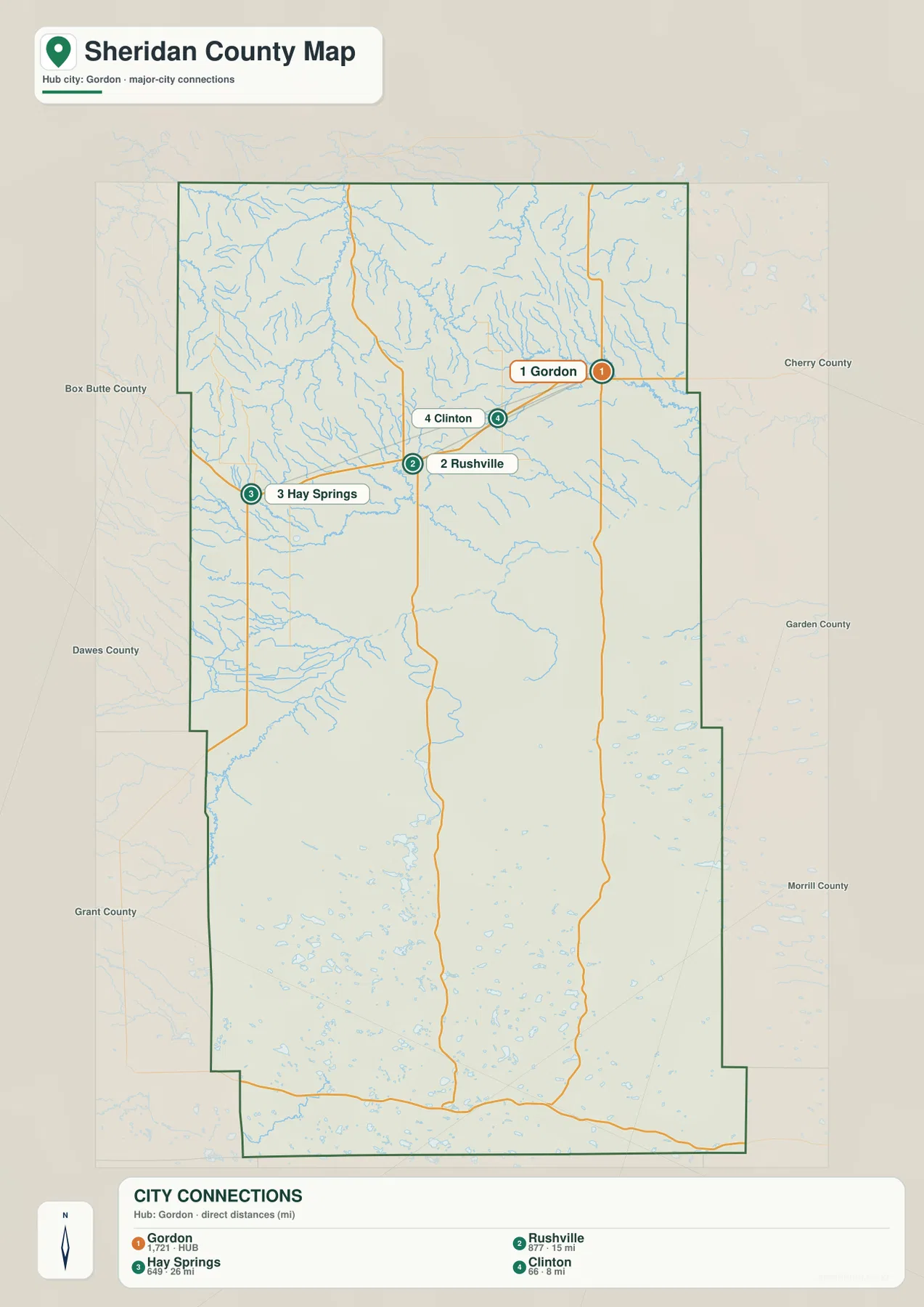
The four points are all concentrated in the northern part of the county. Gordon, Rushville, and Hay Springs follow the same broad east-west belt around U.S. 20, while Clinton sits a short distance north of the Gordon–Rushville line. The southern half of the county has no comparable cluster of incorporated towns, which makes the contrast between the populated north and rural Sandhills especially clear on this simplified map.
Sheridan County tourism also describes Gordon, Rushville, and Hay Springs as northern communities connected by U.S. Highway 20. The city map turns that description into a quick visual comparison, while the general map adds the road network and county boundary. For actual travel time or routing, a current road service is still the appropriate source.
Niobrara River, Pine Ridge creeks, and Sandhills lakes
The Niobrara River is the most prominent waterway on the terrain-and-water map. It crosses the middle of Sheridan County on a winding west-to-east course and occupies a broad lower corridor between the northern ridge country and the Sandhills farther south. North of the river, Rush Creek and Hay Springs Creek descend through the central-western area, while White Clay Creek cuts a deeply branched valley system in the northwest.
Antelope Creek is prominent in the northeast, and the Snake River appears farther east near the middle of the county. Boardman Creek follows part of the western interior. Sheridan County’s tourism history identifies the Niobrara as the county’s principal watercourse and also discusses the local naming of creeks such as White Clay Creek. The supplied map makes those waterways easier to place relative to the towns and terrain.
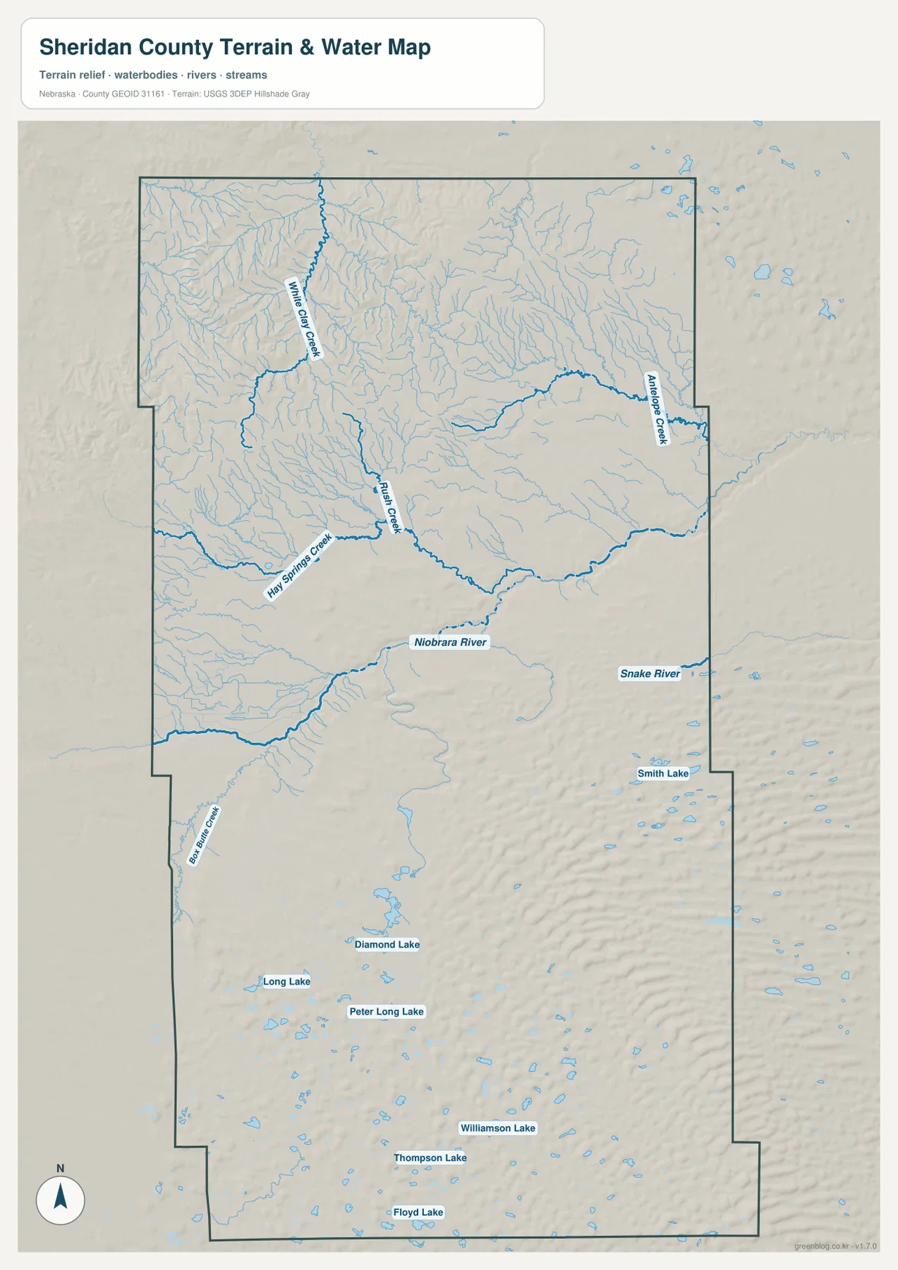
Named lakes become much more common in the southern half. Smith Lake lies toward the east, while Diamond Lake, Long Lake, Peter Long Lake, Williamson Lake, Thompson Lake, and Floyd Lake appear farther south. The map is useful for locating them, but it does not show current water level, water quality, fishing access, boating rules, or public ownership. Those details should be checked with the relevant land or recreation manager before a visit.
Blue line width and color are not measurements of discharge, depth, or flood risk. This is a county-scale reference map showing where streams and lakes are located. Floodplain determinations, water rights, property restrictions, and safety decisions require current information from FEMA, USGS, local natural-resource agencies, or other responsible authorities.
Pine Ridge relief, the Niobrara lowland, and rolling Sandhills
The elevation map shows why Sheridan County does not look like one uniform plain. The northern Pine Ridge area contains sharply cut valleys and ridges, especially in the northwest, where dark greens and browns change over short distances. A lower green corridor follows the Niobrara River through the middle of the county. Farther south, the surface changes again into the repeating rounded forms of the Sandhills.
The displayed surface ranges from about 952 to 1,308 meters, with a mean near 1,164 meters. Some of the strongest local relief occurs in the northern ridge country, while the Niobrara and tributary valleys sit lower than adjacent uplands. The southern Sandhills contain extensive high ground as well, but their form is different: long sequences of rounded dune ridges replace the deeply dissected northern terrain.
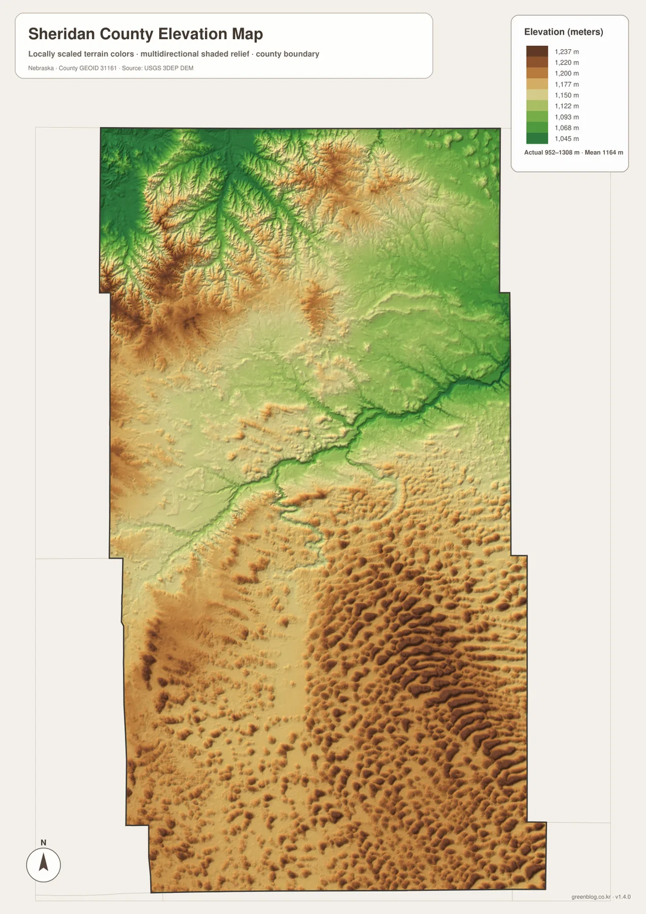
The county’s official website describes pine-covered hills in the north and Sandhills range land in the south. The tourism office adds limestone and rock formations, ponderosa pine forests, prairie grasslands, and farm ground to its description of the northern and central landscape. Those written descriptions match the broad terrain differences visible in the elevation and water maps without requiring the image to function as a detailed geology or land-cover map.
This elevation surface is intended for county-scale comparison, not parcel surveying or engineering. Exact site elevations, road grades, building benchmarks, and construction design values require USGS source elevation data, professional surveying, or another appropriate technical source. The image is best used to compare the major terrain zones and the valleys that separate them.
Rushville, county government, and an 1880s settlement corridor
The official county website describes Sheridan County as roughly 2,470 square miles with a 2020 population of 5,127, making it a large and lightly populated county. Its four incorporated communities are Rushville, Gordon, Hay Springs, and Clinton, all located in the northern portion. That pattern is visible at a glance on the city map, while the southern half is dominated by rural roads, lakes, and Sandhills terrain.
Local tourism history traces Gordon to 1884 and the organization of Rushville and Hay Springs to 1885, when railroad development helped reshape settlement in the region. A county-seat contest involved Gordon, Clinton, Hay Springs, and Rushville; after disputed elections and legal proceedings, Rushville became the county seat in 1888. Because all four communities are close together on the northern map, the historic competition can be placed easily in geographic context.
The county was named for General Philip Sheridan, but its modern geographic identity is just as strongly associated with Pine Ridge, the Niobrara River, and the Sandhills. The northern town corridor reflects the transportation and settlement history of the late nineteenth century, while the central river valley and broad southern rangeland shape the physical landscape. Those two stories—settlement and terrain—are easiest to understand when the map types are viewed together.
Using the maps for printing, teaching, and regional comparison
For a first overview, start with the general county map and find U.S. 20, Gordon, Rushville, and Hay Springs. The city-connections graphic then makes it easy to compare the northern communities and their direct distances from Gordon. Looking south on either map reveals how quickly settlement thins out as the county enters the Sandhills.
The water map is better for tracing the Niobrara River, White Clay Creek, Rush Creek, and the named lakes. The elevation image then shows how those waterways occupy lower valleys between higher ridges and dunes. In a classroom, students can locate the towns first, trace the river corridor next, and finally compare Pine Ridge with the Sandhills on the elevation map.
High-resolution JPG files are more useful than the WebP previews when printing or zooming in on small creek names and road labels. These maps remain regional references rather than legal or safety documents. County boundaries can be checked against Census TIGER/Line data, waterways against USGS National Hydrography, and elevation against the USGS 3D Elevation Program.
Frequently Asked Questions
Where are Gordon, Rushville, and Hay Springs located?
All three are in northern Sheridan County along or close to the U.S. 20 corridor. Gordon is the easternmost of the three, Rushville lies to its west, and Hay Springs is farther west. Clinton is a smaller community north of the line between Gordon and Rushville.
Are the distances on the city-connections map driving distances?
No. The map shows direct straight-line distances from Gordon: about 15 miles to Rushville, 26 miles to Hay Springs, and 8 miles to Clinton. Road travel can be longer depending on the available route and local road alignment.
Can the elevation map be used for surveying or construction design?
No. It is intended to compare Pine Ridge, the Niobrara River valley, and the Sandhills at county scale. Exact site elevations, road grades, and engineering benchmarks require appropriate USGS source data or professional surveying.
Map File Information
Download the four high-resolution JPG maps shown on this page for Sheridan County in one ZIP archive.
- Included Files: Use only the versions confirmed in the article and supplied images
- File Type: Use the confirmed download contents
- Intended Use: Printing, education, presentations, and map-based projects
Related Maps
Sources and references
County-seat, community, area, population, and regional background comes from the official Sheridan County website. Pine Ridge, Sandhills, community, and historical context comes from Sheridan County tourism resources. Federal sources below provide authoritative references for county boundaries, hydrography, and elevation.
- Sheridan County – Official Website
- Sheridan County Tourism – Communities & Landscape
- Sheridan County Tourism – History of Sheridan County
- U.S. Census Bureau – TIGER/Line Shapefiles
- USGS – National Hydrography
- USGS – 3D Elevation Program
Green Map creates custom-edited map images using open geographic data sources such as geoBoundaries, Natural Earth, OpenStreetMap, and government open data. These maps are edited visual materials, not raw data files, and are provided for education, documents, presentations, and graphic reference.