Platte County sits in eastern Nebraska where the broad Platte and Loup river valleys meet a higher, more dissected landscape to the north and west. This Platte County Nebraska Map page brings together county boundaries and roads, the locations of Columbus, Humphrey, Duncan, Platte Center, Lindsay, and Monroe, named rivers and creeks, and an elevation view that makes the contrast between the southern lowlands and higher northwestern ground easy to see. The WebP images on the page are intended for quick viewing, while the download box below provides the same maps as high-resolution JPG files in one ZIP archive.
Columbus is the easiest place to use as an anchor. It lies in the southeastern part of the county near the Loup and Platte rivers, while Highway 81 runs north from the city and Highway 30 follows the southern corridor through Duncan. Farther north, Highway 91 passes Lindsay and Humphrey, and Monroe appears to the west near Highway 22. Looking at those routes first gives the rest of the county a clear frame before moving to the water and elevation maps.
Table of Contents
Columbus, the main highways, and the county outline
The general county map emphasizes how strongly Columbus stands out in the southeast. Several important roads meet or pass near the city, making it a practical reference point for reading the rest of the page. Highway 81 heads north from Columbus toward the interior of the county, while Highway 30 extends westward along the southern side toward Duncan. Highway 22 reaches west from the central-southern area toward Monroe, and Highway 39 appears near the western edge.
Northern Platte County has a different road pattern. Highway 91 stretches east-west across the upper part of the county, passing Lindsay and Humphrey before continuing toward Creston. That route makes the spacing of the northern communities especially easy to understand. Instead of treating the county as a single Columbus-centered road network, the map shows a southern river corridor and a northern east-west route serving communities that are separated by a large rural interior.
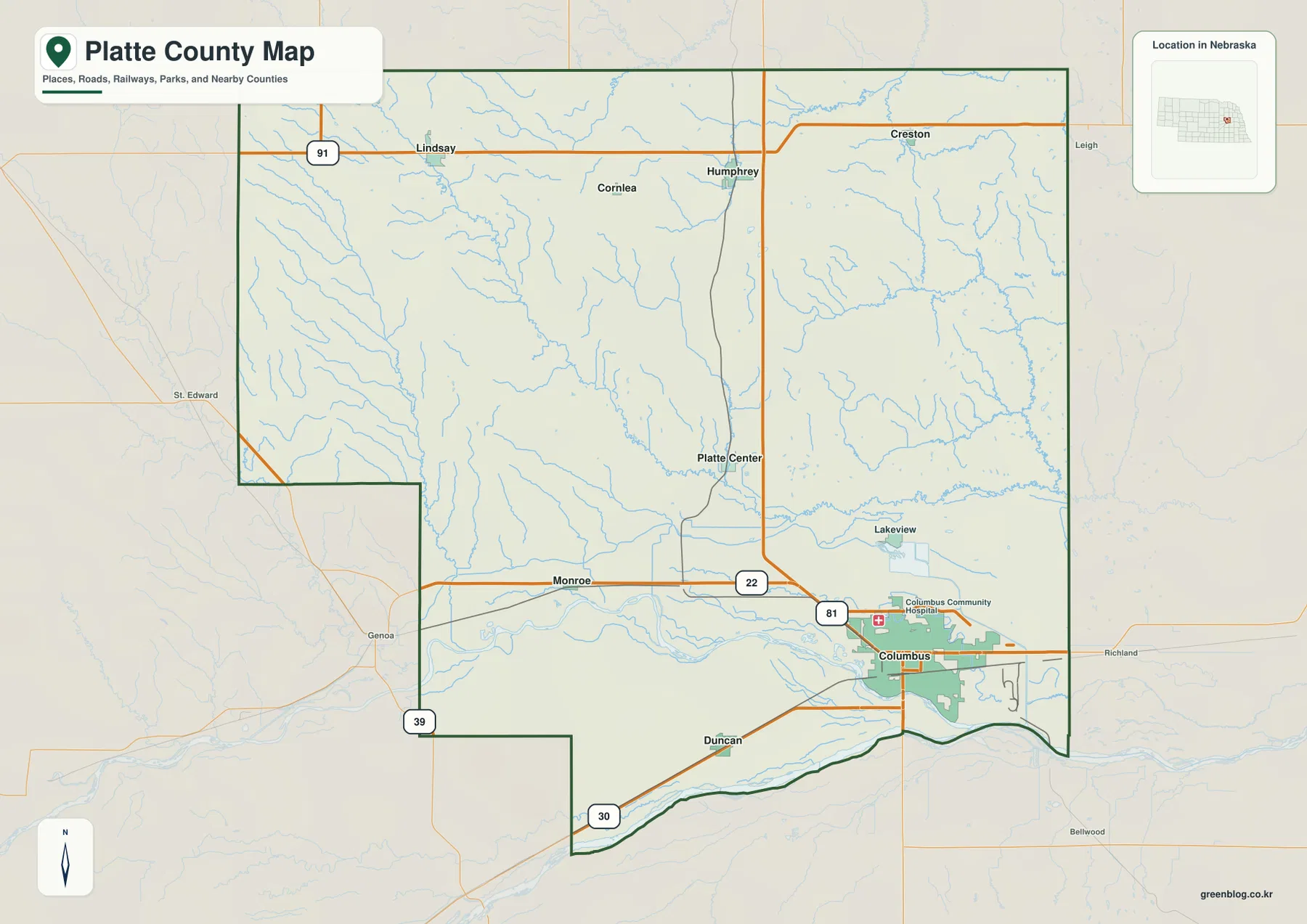
The county boundary is not a simple rectangle. Its southern edge follows the broad Platte River area, and the southwestern side includes a noticeable step in the outline. Nearby county names on the background map help place Platte County among Nance, Boone, Madison, Merrick, Colfax, Butler, and Polk counties. Those labels are useful for orientation, but the dark county outline should be used to distinguish places inside Platte County from nearby communities outside it.
Platte County’s official history identifies Columbus as the county seat and explains that the county took its name from the Platte River along its southern boundary. That background fits what is visible on the map: Columbus is the dominant settlement, and the river corridor forms one of the county’s clearest geographic edges. Current road conditions, construction, and restrictions can change, so the image works best as a regional reference rather than a substitute for live navigation.
How the major communities are distributed
The city distribution map strips away much of the road detail and focuses on six major places. Columbus is in the southeast, Duncan is southwest of it near the lower edge of the county, and Platte Center lies farther north in the east-central interior. Humphrey occupies the northern part of the county, Lindsay is farther west along the northern tier, and Monroe is positioned in the southwest. Together, the points show a dispersed settlement pattern rather than a tight cluster.
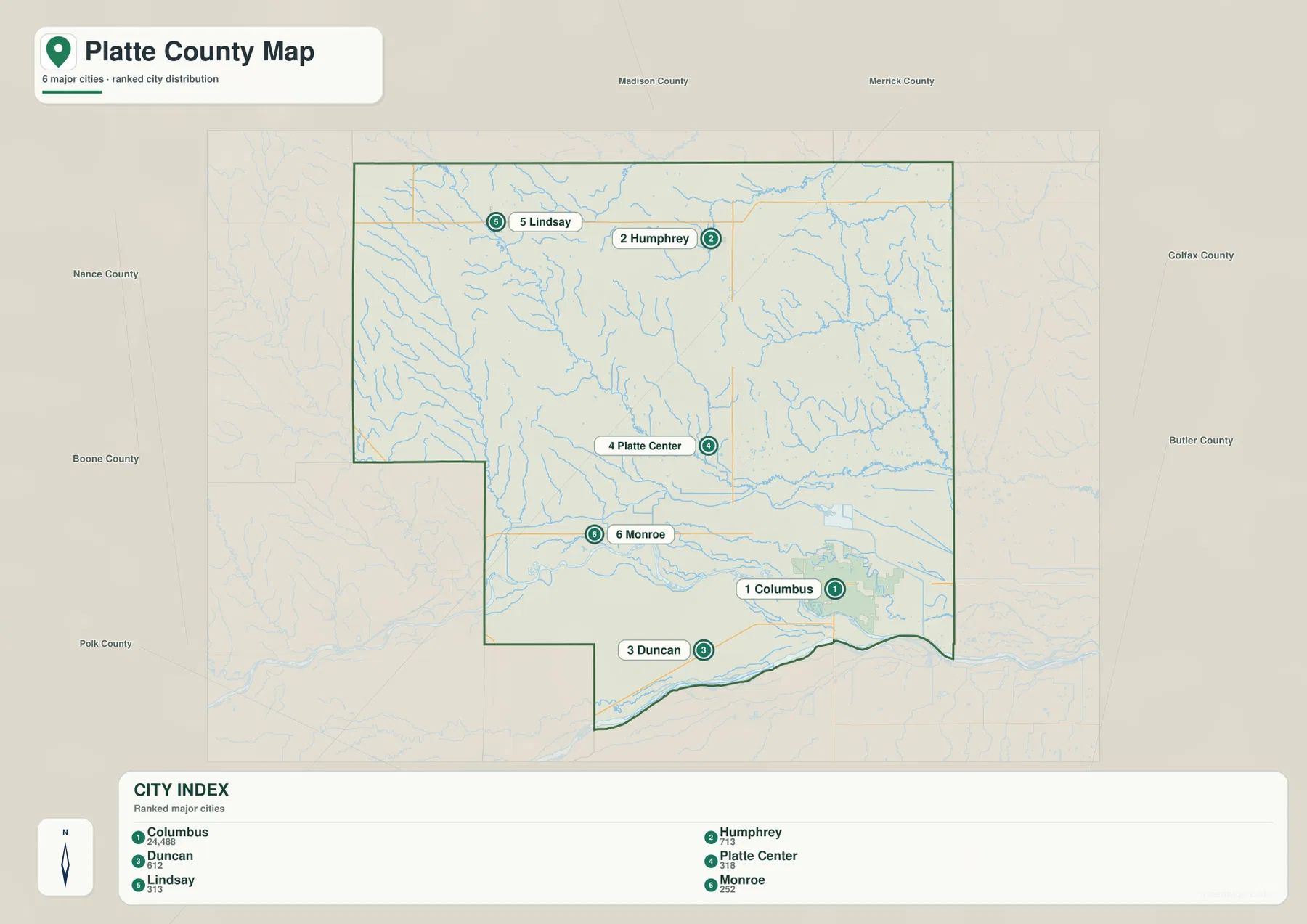
The ranked city index is useful for orientation, but it should not be read as a driving-distance diagram. The relative positions show which communities are north, west, or south of Columbus, while actual travel depends on the road network, river crossings, and local intersections. Duncan may look close to Columbus on the page, for example, yet a real trip still follows the available roads through the river-valley landscape.
Platte Center is especially helpful as a geographic reference because it appears near the middle of the county, even though it is not the largest settlement. Humphrey and Lindsay make the northern section easier to understand, while Monroe provides a western reference and Duncan marks the southern river corridor. For classroom use, it can be useful to begin with this simpler distribution map and then return to the general map to add highways and neighboring places.
The county’s official information lists additional incorporated places beyond the six shown in the ranked map. That difference is expected because the city image is a selected overview rather than a complete municipal register. Anyone who needs current population figures, legal municipal status, or official boundaries should consult the county and Census sources directly instead of treating the labels on this image as a complete administrative list.
The Loup and Platte rivers along the southern lowlands
Water is one of the strongest features of Platte County’s southern landscape. The Platte River follows the county’s lower edge, while the Loup River comes in from the west and approaches the Platte near Columbus. Those two broad river corridors create a wide lowland zone that looks very different from the more heavily cut terrain farther north. The water map makes that contrast clear even before the elevation colors are introduced.
The Loup River Canal runs roughly parallel to part of the Loup River north of the main channel. Near Columbus, Lake August and Lake Milton are also labeled, giving the southeastern area several distinct water features within a relatively small space. The map is designed to show locations and named features, not canal operating conditions, water depth, boating access, or current recreation rules. Those questions require up-to-date information from the responsible agencies.
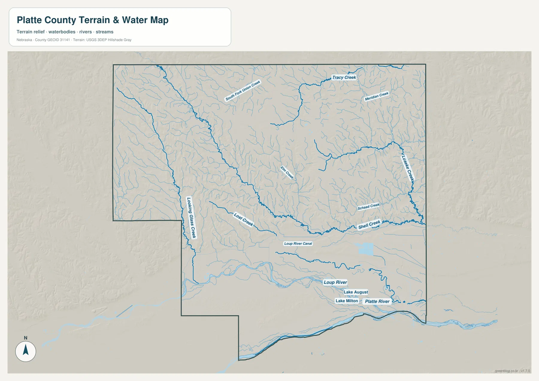
Northern and central Platte County contain a much finer network of creeks. Labels on the map include South Fork Union Creek, Tracy Creek, Meridian Creek, Elm Creek, Looking Glass Creek, Lost Creek, Schaad Creek, Loseke Creek, and Shell Creek. These smaller channels help explain why the northern terrain is etched by so many narrow valleys rather than appearing as an uninterrupted plain.
Shell Creek is especially prominent across the southeastern side, with Loseke Creek and Schaad Creek nearby. Looking Glass Creek and Lost Creek provide useful western references, while the smaller northern creeks occupy higher ground before descending toward larger channels. Line thickness on the map does not represent actual stream width or discharge, and seasonal flow conditions cannot be inferred from this static regional image.
This map should not be used as a flood-zone or regulatory map. It shows named waterways and terrain at a county scale, but flood risk, legal setbacks, water quality, and private-property access require separate official sources. For general geography, however, the map is a convenient way to see how the Loup and Platte rivers relate to Columbus and how the smaller creek valleys fill the northern half of the county.
Elevation from the river bottoms to the higher northwest
The elevation map adds a different view of the same geography. Darker greens dominate the southern river bottoms, while lighter greens, yellows, and browns become more common toward the west and northwest. The legend shows representative color breaks from about 436 to 560 meters, and the map notes an actual surface range of roughly 426 to 583 meters with a mean near 495 meters. The important point is the regional contrast rather than any single number.
Higher western and northwestern areas are cut by many small valleys, so the brown terrain is not a smooth plateau. The shaded relief reveals ridges and drainage cuts that correspond to the creek network shown on the water map. A long lower corridor also reaches through the north-central area, showing that elevation varies locally even within the broader pattern of higher ground away from the southern rivers.
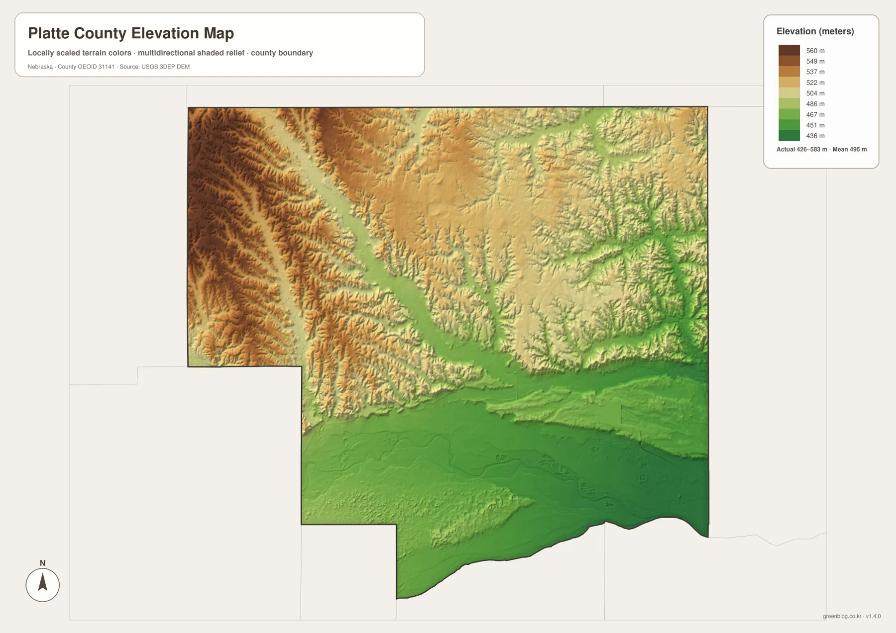
Several lower green valleys also extend into the eastern half of the county. Shell Creek and Loseke Creek occupy some of those lower routes, making the relationship between stream location and terrain easier to recognize when the elevation and water maps are viewed together. By contrast, broad areas along the western border remain in higher colors, producing a clear difference between the river-bottom landscape and the uplands.
The elevation image is generalized for county-scale comparison. It is not survey-grade information and should not be used to establish parcel elevations, road grades, construction benchmarks, or drainage design. Those tasks require the original USGS elevation data and, where necessary, professional surveying. For teaching, regional comparison, and printed reference, the shaded map is useful because the height differences are visible immediately.
Why Columbus matters in the county’s history
The official Platte County history says the county was established in 1856 and that Columbus became the county seat. Early settlement at Columbus developed near the Loup and Platte rivers, and later railroad construction accelerated the community’s growth. The present-day map does not show that history directly, but it does show why the site is geographically important: Columbus sits beside the major rivers and at a point where several transportation routes converge.
The county’s name also comes from the Platte River, according to the official county account. That makes the southern river more than a background feature on the map. It helps define the county edge, provides a clear physical reference for Columbus and Duncan, and separates the low southern terrain from the higher interior. Comparing the boundary and water maps is a simple way to see how closely the county’s identity is tied to the river.
History Nebraska’s Platte County records guide adds broader context about settlement, county government, and the later importance of public power in the region. This page is not a historical map, so it should not be used to reconstruct former rail lines, old property boundaries, or vanished settlements. A practical research method is to locate a present-day place on these maps first, then use historical records and period maps for changes through time.
Choosing the most useful map for a task
For a quick overview of the county, start with the general map. It combines the county outline, major roads, communities, nearby places, and background water features. Columbus is the main anchor, Highway 81 provides a strong north-south reference, Highway 30 defines much of the southern travel corridor, and Highway 91 helps organize the northern communities. This version is the most useful when someone needs several kinds of information on one page.
Use the city distribution map when roads are less important than settlement location. It quickly separates Columbus, Duncan, Platte Center, Humphrey, Lindsay, and Monroe without the visual clutter of a full road network. Use the water map when the Loup River, Platte River, Shell Creek, Loseke Creek, or smaller tributaries are the main interest. The elevation map is best when the question concerns the low river bottoms and the higher, more dissected terrain to the northwest.
Viewing the maps together also reveals relationships that are easy to miss on a single image. Columbus is clearly southeastern on the general and city maps; the water map places the city beside the Loup-Platte river system; and the elevation map shows the same area in lower green tones. In the northwest, the water and elevation views explain why so many small creeks occupy narrow valleys across higher ground.
The downloadable JPG originals are better than the WebP previews when the map will be printed or enlarged. Each original image is 3638×2572 pixels, leaving more room to inspect smaller labels and stream names. High resolution does not turn the maps into legal boundary surveys, engineering plans, flood determinations, or emergency navigation products, so official current sources should still be used for decisions that require that level of precision.
Frequently Asked Questions
Which map is best for comparing Columbus with the other major communities?
The city distribution map is the simplest choice. It shows Columbus in the southeast, Duncan to the southwest, Platte Center in the east-central interior, Humphrey in the north, Lindsay in the northwest, and Monroe in the southwest. For an actual driving route, pair it with the general county map and current navigation information.
Where can I see the Loup River and Platte River most clearly?
The terrain and water map shows both major rivers most clearly. The Platte River follows the southern edge of the county, while the Loup River crosses the southern interior toward Columbus. The same map also labels the Loup River Canal, Shell Creek, Loseke Creek, Looking Glass Creek, and several other waterways.
Can the elevation map be used for surveying or construction design?
No. The elevation image is a county-scale reference for relative height differences. Parcel elevations, road grades, construction benchmarks, drainage design, and legal boundaries require appropriate USGS source data, professional survey information, and any other official records needed for the specific task.
Map File Information
Download the four high-resolution Platte County JPG maps shown on this page in one ZIP file.
- Included Files: Use only the versions confirmed in the article and supplied images
- File Type: Use the confirmed download contents
- Intended Use: Printing, education, presentations, and map-based projects
Related Maps
Sources and references
County history and the role of Columbus were checked against Platte County’s official information and the History Nebraska records guide. The Census Bureau and USGS provide the primary public sources for boundary, hydrography, and elevation data used to verify the map topics.
- Platte County Nebraska – About Platte County
- History Nebraska – Platte County records guide
- U.S. Census Bureau – TIGER/Line Shapefiles
- USGS – National Hydrography
- USGS – 3D Elevation Program
Green Map creates custom-edited map images using open geographic data sources such as geoBoundaries, Natural Earth, OpenStreetMap, and government open data. These maps are edited visual materials, not raw data files, and are provided for education, documents, presentations, and graphic reference.