Logan County occupies a sparsely settled part of west-central Nebraska where the South Loup River crosses the southern interior and the rolling Sandhills begin to dominate the country to the north and west. Stapleton is the county seat and the main road reference, positioned at the junction of U.S. 83 and Nebraska Highway 92. Gandy lies east along the South Loup corridor, while most of the northern half contains ranch country, rural roads, and only a few named water features. This page connects the settlement pattern with the river network and an elevation range of about 831 to 995 meters. The four original high-resolution JPG maps can also be downloaded together in a ZIP file for printing or close inspection. High-resolution map files are available for download in the section below.
The county’s official website identifies Stapleton as the seat and lists Gandy and Stapleton as its villages. Stapleton’s community site describes Logan County as lying along the southern edge of the Nebraska Sandhills and notes that the South Loup River begins just west of the village before continuing east. That description matches the maps well: settlement and the principal highways cluster near the southern river corridor, while higher and more thinly populated rolling terrain spreads across the west and north.
Table of Contents
Stapleton makes U.S. 83 and Highway 92 the county’s simplest road reference
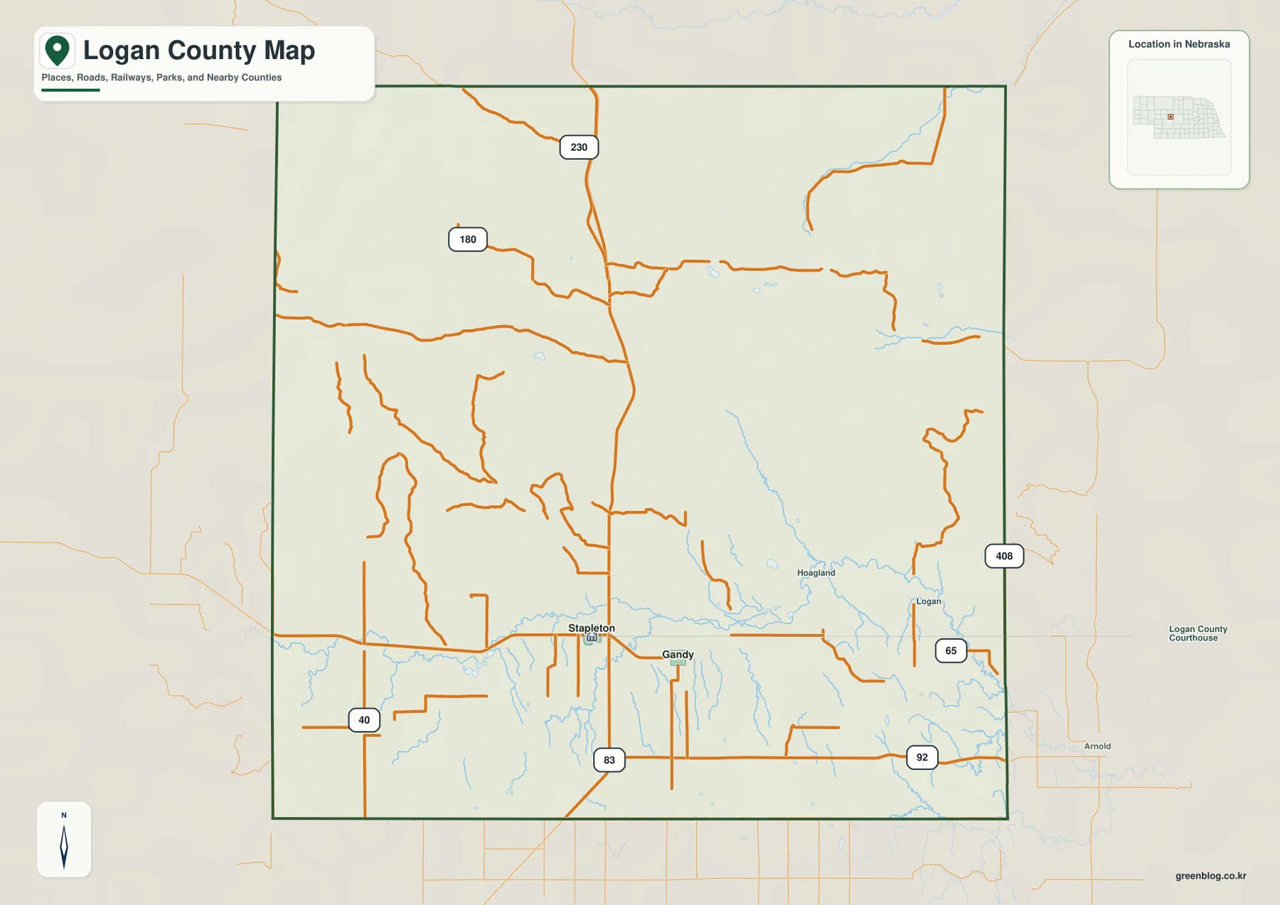
Stapleton is the easiest place to begin on the general county map. U.S. 83 runs north–south through the village area, while Nebraska Highway 92 crosses the county east–west along the South Loup corridor. Stapleton’s official community page highlights the junction of those two highways as a defining location. In a county with very few towns, one road crossing provides a much stronger geographic anchor than a dense street network would.
Gandy lies east of Stapleton near the South Loup River. Hoagland and Logan appear farther east as smaller place labels, while most of the northern half is marked more by rural roads than by settlement names. Thomas County is to the north, McPherson County to the west, Lincoln County to the south, Custer County to the east, and Blaine County touches the northeast. Those surrounding counties help show how centrally Stapleton sits within the southern part of Logan County.
The county boundary is fairly regular, but the landscape inside it is not. Near the South Loup, roads and tributaries bend through lower ground; farther north, road spacing becomes wider as the terrain turns into open ranch country. Using Stapleton, U.S. 83, Highway 92, and the river together creates a much clearer mental map than trying to memorize every numbered rural road.
The ranked settlement map reduces Logan County to Stapleton and Gandy
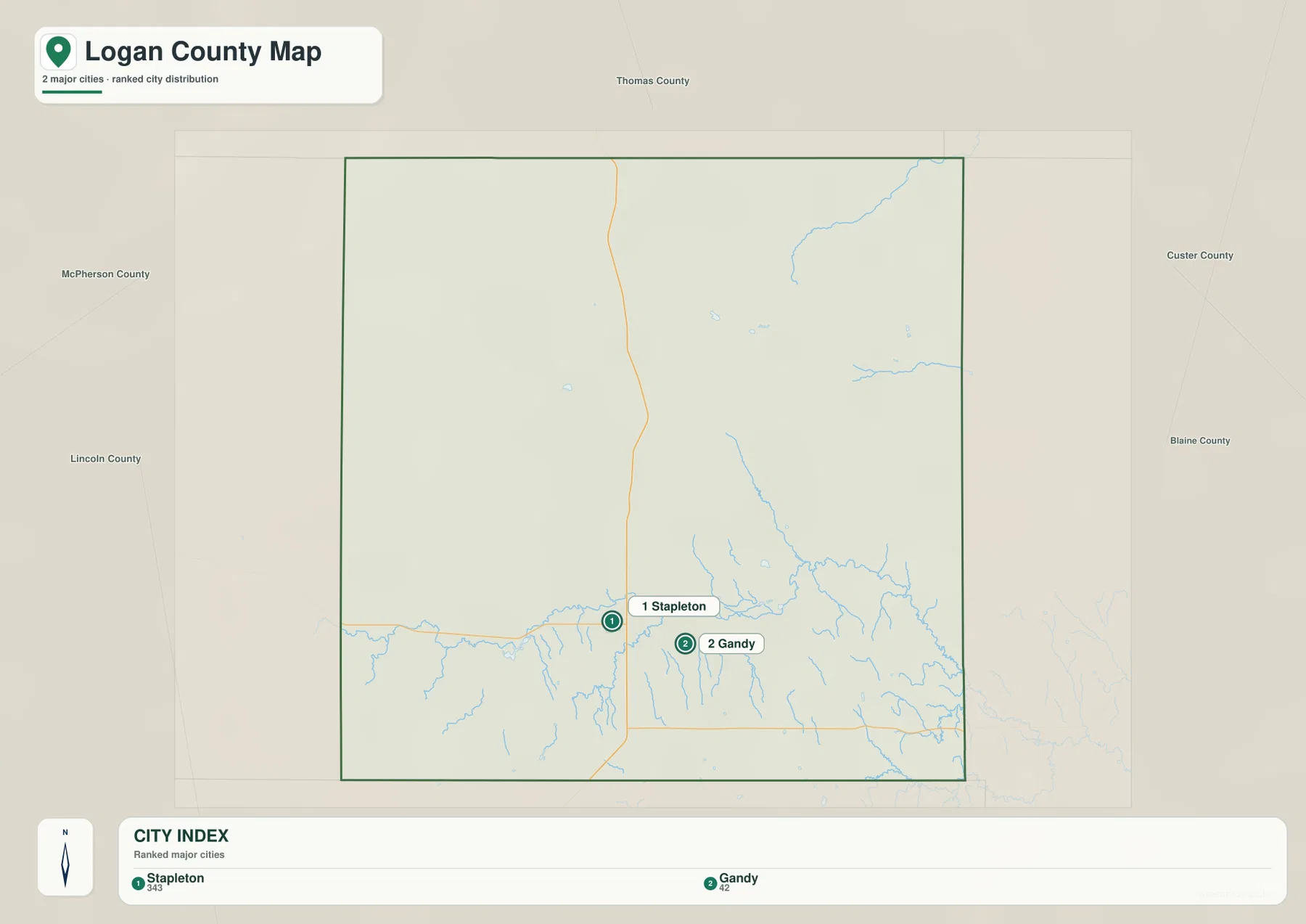
The city-distribution map is unusually simple. It ranks Stapleton first and Gandy second, with printed index values of 343 and 42. Those values belong to the supplied graphic and should not be treated as a live population table; recent official counts should be checked through Census or county sources when current demographics matter. For geographic reading, the important point is the extreme concentration of named settlement in the southern river corridor.
The two villages also have different roles. Stapleton is the current county seat and the road center. Gandy is much smaller today but remains important to county history. The Logan County courthouse page maintained by the Stapleton community notes that Gandy served as the county seat before the government center moved to Stapleton in 1929.
Nothing comparable appears across the broad northern half of the ranked city map. That absence is meaningful: Logan County is better understood through ranch country, Sandhills relief, streams, and long rural roads than through a network of towns. The South Loup valley gathers the two main villages into one relatively narrow part of a much larger county.
The South Loup River gathers settlement into the county’s southern lowland
The South Loup River is the dominant water feature on the terrain-and-water map. It enters from the west, passes through the Stapleton and Gandy part of the county, and continues east. Stapleton’s community page says the river begins just west of the village, which helps explain why the local settlement story is so closely tied to this particular valley. Around Stapleton, numerous short tributaries descend from the uplands and join the main channel.
East of Gandy, the river becomes increasingly sinuous as it approaches the county boundary. Short tributaries enter from both sides, and Sand Creek creates a separate lower corridor in the southeast. The same area appears as green low terrain on the elevation map, clearly separating the river floor from the higher Sandhills and rolling uplands nearby.
Northern Logan County has fewer prominent water features but still includes useful landmarks. Wild Horse Creek crosses the northeast as a long named stream, and Cody Lake appears as a small water body in the north-central interior. These features are valuable because there are so few towns in that part of the county. The south is easiest to navigate by village and river, while the north is better understood through waterways, relief, and rural roads.
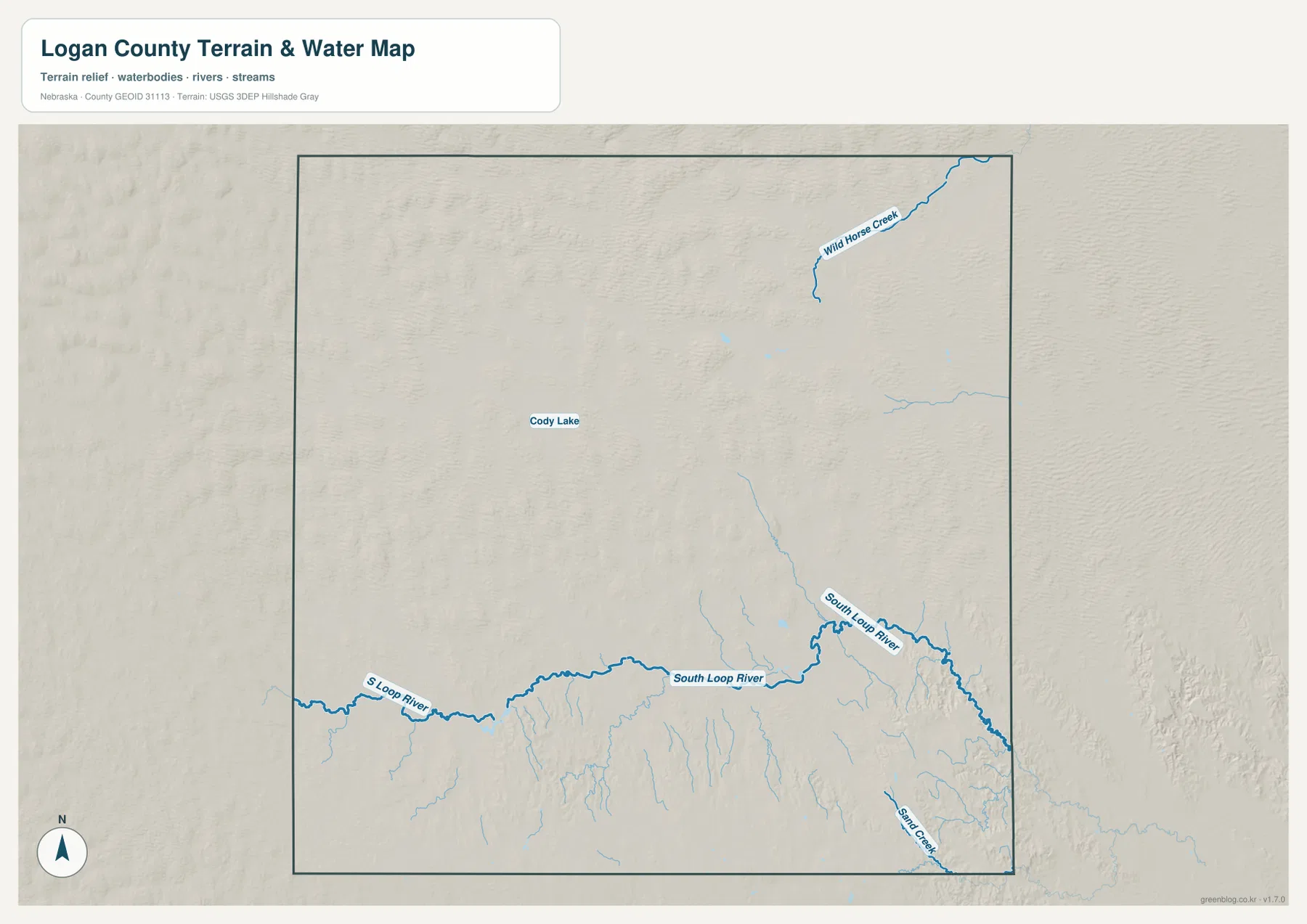
This is a general water-reference map, not a flood, parcel, access, or navigation product. Stream conditions, crossings, and access can change, and small Sandhills waterways may look different from season to season. Current field decisions should rely on the appropriate agency or local authority rather than this static county-scale map.
Elevation falls from 995-meter western Sandhills toward lower eastern ground
The elevation surface gives Logan County an actual range of about 831 to 995 meters, with a mean near 908 meters. The highest brown terrain is concentrated across the west and northwest, while greener lower colors become more common toward the east and northeast. The difference of roughly 164 meters is not mountainous, but it is enough to make the rounded Sandhills, river valley, and lower eastern interior visually distinct.
Western Logan County contains repeated rounded ridges and dune-like hills rather than one continuous high plateau. This matches Stapleton’s description of the county as lying along the southern edge of the Nebraska Sandhills. The northwest shows the most continuous high colors, while the central interior gradually opens into lower spaces between the hills.
The South Loup corridor is easy to trace as lower green ground across the southern part of the county. Around Stapleton and Gandy, tributary valleys cut narrow paths into higher terrain before reaching the river. Farther east, the average surface becomes lower, though scattered ridges keep the county from looking like a flat plain.
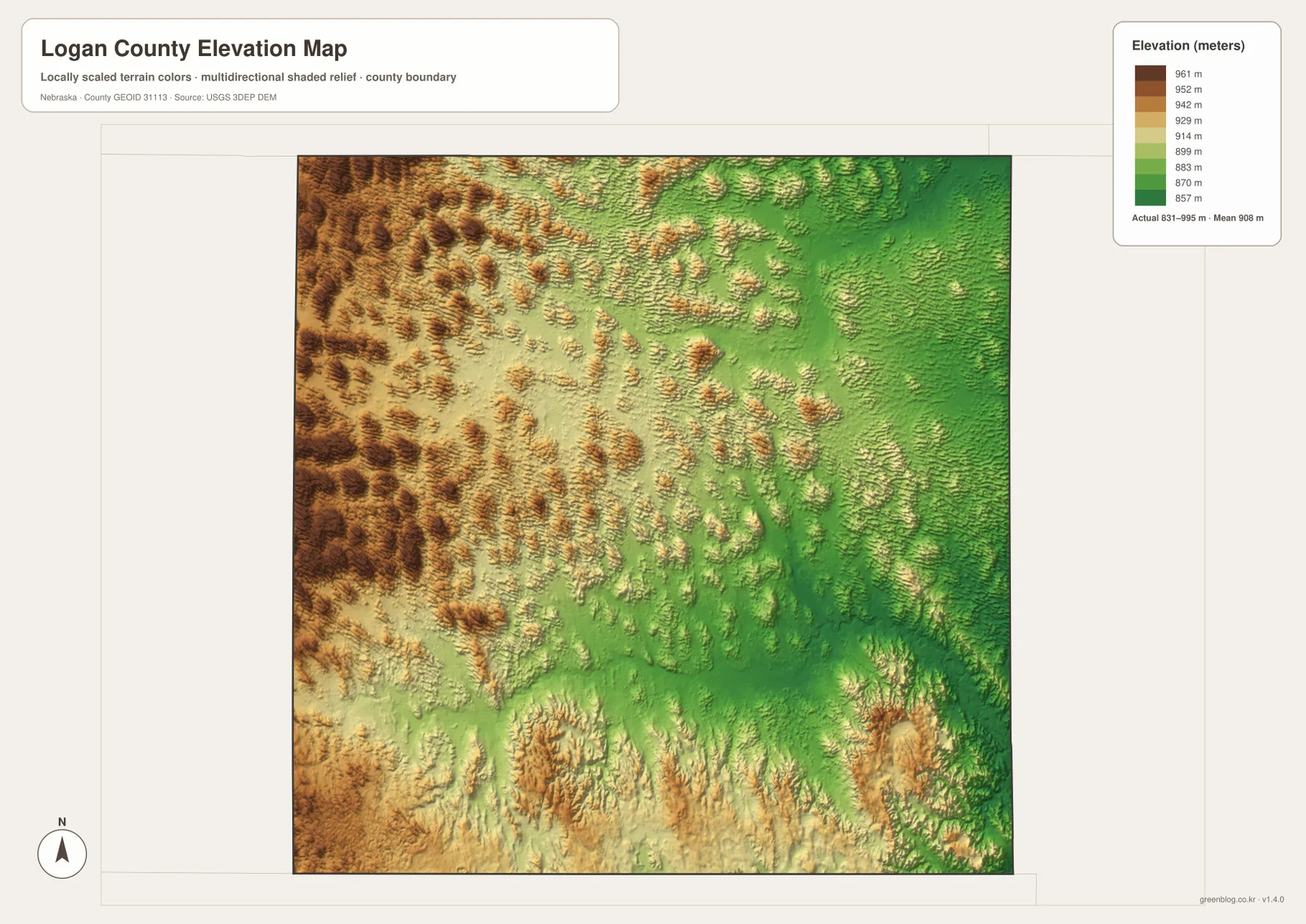
The elevation map is generalized for county-scale comparison. It should not be used as survey-grade information for a ranch parcel, building site, drainage design, road grade, or engineering project. Those tasks require current detailed elevation data such as the USGS 3D Elevation Program and, when necessary, professional measurements.
The move from Gandy to Stapleton reflects changing transportation as well as local history
The relationship between Gandy and Stapleton adds an unusually clear historical layer to the maps. A Stapleton community courthouse page records that Gandy served as the county seat before the seat moved to Stapleton in 1929. Stapleton itself expanded after the railroad reached the area in the early twentieth century and remains the location of the courthouse and county offices today.
The modern road map helps explain why Stapleton works so well as the present center. Both villages lie close to the South Loup River, but Stapleton also occupies the junction of U.S. 83 and Highway 92. In a county with a large area and very sparse settlement, that crossing provides practical access from several directions. Gandy remains a small village but still marks an important stage in Logan County’s administrative history.
The same geography also fits the county’s agricultural character. Stapleton community information emphasizes ranching and farming, and the maps show why: outside the two villages, rural roads, broad grazing country, rolling Sandhills, and the South Loup meadows dominate the landscape. Settlement, transportation, and topography all converge in the southern part of the county.
Choose the map according to the feature you need to locate
The general county map is the best starting point for Stapleton, Gandy, U.S. 83, Highway 92, and the surrounding county directions. The ranked settlement map removes most road detail and makes the contrast between the two villages and the largely unpopulated northern half especially clear.
For natural geography, the terrain-and-water map is more useful because it labels the South Loup River, Wild Horse Creek, Cody Lake, Sand Creek, and numerous tributaries. The elevation map then shows why those channels occupy particular valleys and how the higher western Sandhills differ from the lower east. Using the two together gives a much better sense of the county than either one alone.
A practical study sequence is to find Stapleton and the highway junction first, follow the South Loup east toward Gandy, and then compare the western and northern uplands on the elevation surface. The WebP images on the page are quick previews, while the original JPG files are better for enlarging labels or printing. Legal boundaries, flood decisions, live road conditions, surveying, and engineering work should use the latest authoritative source for the specific task.
Frequently Asked Questions
Where is the Logan County seat?
Stapleton is the current county seat. The official Logan County website identifies it as the seat, and the map shows it at the junction of U.S. 83 and Nebraska Highway 92. Gandy served as an earlier county seat before the government center moved to Stapleton in 1929.
Is Logan County part of the Nebraska Sandhills?
Stapleton’s official community site describes Logan County as lying on the southern edge of the Nebraska Sandhills. The elevation map supports that description by showing broad rounded uplands in the west and northwest, with the South Loup River occupying a lower southern corridor.
Can the 831–995 meter elevation range be used for surveying or construction?
No. The elevation range is a generalized county-scale reference. Parcel surveys, construction, drainage design, and road engineering require current detailed elevation data and professional measurements rather than this regional map.
Map File Information
The county, city-distribution, terrain-and-water, and elevation maps are available together in one ZIP file. It contains four original high-resolution JPG maps suitable for detailed viewing and printing.
- Included Files: County map, city-distribution map, terrain-and-water map, elevation map
- File Type: JPG files in a ZIP archive
Related Maps
Sources and references
These official and public sources provide additional context for Logan County government, Stapleton and Gandy history, administrative boundaries, waterways, and elevation.
- Logan County, Nebraska – About Our County – county seat, area, and local information
- Village of Stapleton – About – Sandhills, South Loup River, and community context
- Logan County Courthouse – Stapleton – county-seat history of Gandy and Stapleton
- U.S. Census Bureau TIGER/Line – administrative boundary data
- USGS National Hydrography – river and stream data
- USGS 3D Elevation Program – elevation data
Green Map creates custom-edited map images using open geographic data sources such as geoBoundaries, Natural Earth, OpenStreetMap, and government open data. These maps are edited visual materials, not raw data files, and are provided for education, documents, presentations, and graphic reference.