Holt County occupies a broad part of north-central Nebraska where O’Neill, Atkinson, Stuart, Chambers, Ewing, and Inman are spread across a landscape shaped by the Elkhorn and Niobrara river systems. O’Neill is the easiest central reference because U.S. 20 and U.S. 281 meet there, while U.S. 275 approaches from the southeast, Atkinson and Stuart extend the main settlement corridor westward, and Chambers sits well to the south. This page compares county boundaries and roads, the distribution of the larger communities, waterways and lakes, and county-wide elevation. The original high-resolution JPG map files can also be downloaded together in a ZIP archive for printing or closer inspection.
The county is large enough that a single town-centered view can be misleading. Holt County’s official website describes it as one of Nebraska’s largest counties and gives an area of roughly 2,412 square miles. On the maps, that size translates into several distinct landscapes: the Elkhorn River corridor through the middle, higher Sandhills country in the southwest, the Niobrara River along the northern edge, and many smaller valleys cutting toward the eastern and northern borders. Reading the settlement, water, and elevation maps together makes those differences much easier to see than a boundary outline alone.
Table of Contents
O’Neill anchors a long settlement corridor from Stuart toward Ewing
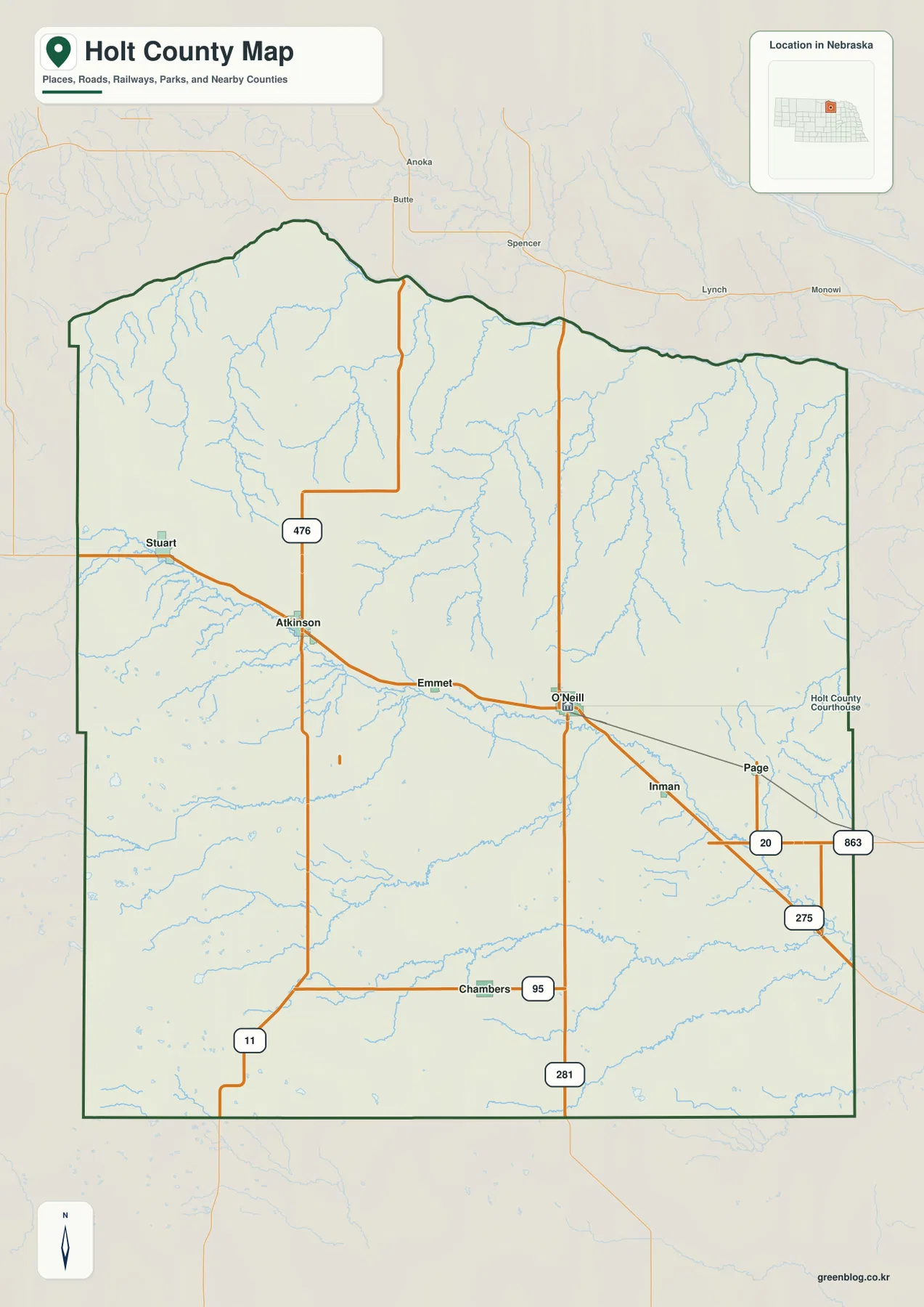
O’Neill is the clearest starting point on the general county map. It lies slightly east of the county’s center and near the junction of U.S. 281 and U.S. 275. From O’Neill, the main westward line passes Emmet and reaches Atkinson, then continues toward Stuart near the western side of the county. That sequence broadly follows the Elkhorn River lowland, so roads, towns, and a major watercourse appear in the same part of the map. O’Neill is also the county seat, which gives the town an administrative role in addition to its position within the transportation network.
East and southeast of O’Neill, Inman sits along the route toward Ewing, while Page lies farther to the east near the U.S. 20 corridor. Ewing is close to the eastern county line and is separated from O’Neill by a much broader rural area than the compact map symbol might suggest. Chambers forms another important reference in the south, away from the central Elkhorn corridor and near Nebraska Highway 95. These locations show that Holt County does not have one simple line of communities; instead, it has a central river-and-road belt with additional settlement points extending south and east.
Stuart and Atkinson provide the main orientation points in the west. Stuart lies near the western edge along U.S. 275, and Atkinson is farther east where several roads branch toward northern and southern rural areas. The general map is useful for understanding these relative positions because it keeps the county boundary, communities, and major numbered roads on the same sheet. It is not a live navigation product, however, so road closures, construction, winter conditions, and exact travel times should always be checked with current transportation information before a trip.
The surrounding counties help define Holt County’s broad position in north-central Nebraska. Boyd County is to the north, Keya Paha County to the northwest, Rock County to the west, Loup County to the southwest, Garfield and Wheeler counties to the south, and Antelope and Knox counties to the east. The northern boundary is less geometric than the straighter southern and western edges because it follows terrain near the Niobrara River. Using the river together with the neighboring county labels is an easier way to remember the shape of the northern edge than memorizing the boundary line by itself.
The six-city index shows how widely Holt County’s population centers are separated
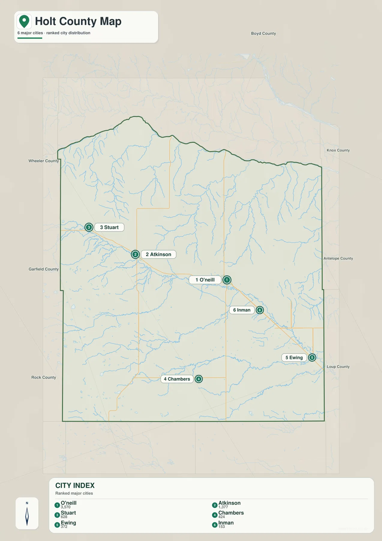
The city-distribution map ranks six major communities within Holt County. O’Neill is marked first, Atkinson second, Stuart third, Chambers fourth, Ewing fifth, and Inman sixth. The ranking is useful as a visual index rather than an administrative hierarchy. What matters most is the geography: O’Neill is near the east-central part of the county, Atkinson and Stuart extend westward, Chambers is well to the south, and Ewing and Inman occupy the eastern side. The arrangement immediately shows that the county’s important settlement points are dispersed across a large area rather than clustered in one compact urban zone.
The index printed on the map lists O’Neill at 3,570, Atkinson at 1,377, Stuart at 628, Chambers at 424, Ewing at 372, and Inman at 153. Those numbers are part of the supplied city map and are best used to understand relative scale within the graphic. Anyone needing current official population counts should consult the latest Census release rather than treating the index as a live demographic table. For map reading, the main point is clear: O’Neill is substantially larger than the other labeled communities, while the remaining towns form much smaller centers spread across western, southern, and eastern Holt County.
The spacing among the six towns also reveals the practical effect of the county’s size. Stuart and Atkinson are separated from O’Neill by a long stretch of rural land, Chambers sits far south of the main west–east settlement belt, and Ewing is close to the eastern boundary. Inman lies between the O’Neill area and the southeastern route toward Ewing. A close-up map of one town would hide these relationships, but the county-scale view makes it obvious why local orientation depends on several different reference points rather than a single downtown center.
The county seat’s location also has historical context. History Nebraska notes that Holt County was organized in 1876 and that the first county seat was at Paddock near the northern part of the county. After an election in 1879, the county seat moved to O’Neill, a more centrally located community. The same source describes repeated disputes over county division, reflecting how difficult it was to administer such a large territory. On a modern map, O’Neill’s location near major east–west and north–south routes helps explain why its position has remained important.
The Niobrara forms the northern frame while the Elkhorn cuts through the middle
Two rivers provide the strongest natural framework on the terrain-and-water map. The Niobrara River follows the northern edge of Holt County, creating a recognizable boundary zone with steep tributary valleys extending southward. The Elkhorn River crosses the county much farther south, entering from the west-central side and continuing diagonally toward the east. Because the rivers occupy separate parts of the county rather than one shared valley, northern Holt County and the central settlement corridor have noticeably different drainage and terrain patterns.
The Elkhorn River lies close to the Stuart–Atkinson–O’Neill belt and is joined by many smaller streams from both the north and south. On the water map the main stem is emphasized with a heavier blue line, making it easy to distinguish from the finer tributaries. West of O’Neill and around Atkinson, several drainage lines converge toward the river. Farther east, the river continues through lower ground toward the Inman and Ewing side of the county. Comparing this map with the road map shows why the central corridor is such an effective geographic reference for both communities and transportation.
South of the main Elkhorn corridor, the South Fork Elkhorn River is another prominent stream. It crosses the southern half of the county and receives water from smaller channels including Dry Creek. Cache Creek forms a long drainage in the southeast, while other unnamed tributaries create a dense branching pattern toward the eastern boundary. These waterways show that southern Holt County is not a featureless plain. Even where large towns are absent, the land is divided by shallow valleys, intermittent channels, and small lakes that become clearer when the shaded terrain is viewed together with the blue water lines.
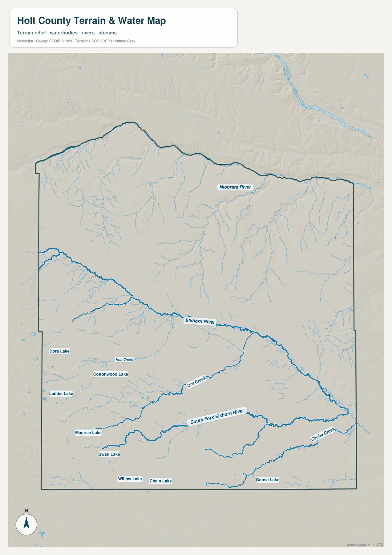
This water-reference map is intended for geographic orientation, not for flood decisions, navigation, property boundaries, or real-time river conditions. The location of a stream on the map does not indicate current discharge, channel access, or legal water rights. Large rivers such as the Niobrara can also shift within their valley over time. For general study, the map is valuable because it shows which drainage belongs to which part of the county; for safety, engineering, or regulatory questions, current official data should be used instead.
Small lakes from Dora Lake to Goose Lake distinguish the southern Sandhills
The water map becomes more distinctive in the south and southwest, where a series of named lakes is scattered across the Sandhills landscape. Dora Lake, Cottonwood Lake, and Lambs Lake appear in the western half, while Maurice Lake and Swan Lake lie farther south. Near the southern boundary, Willow Lake and Chain Lake provide additional reference points, and Goose Lake is labeled in the southeastern part of the county. These are not one connected reservoir system. Their separation across broad upland terrain is part of what makes southern Holt County look different from the continuous Elkhorn River corridor farther north.
Holt Creek provides a useful smaller landmark between the western lake country and the central drainage network. Dry Creek is more prominent farther south and flows eastward before joining the broader Elkhorn system, while Cache Creek occupies a long valley in the southeast. The branching blue lines line up closely with low areas on the elevation map. Looking at the two maps together explains why the stream network has its shape: water is concentrated in the lower channels between broad rolling uplands rather than spread evenly across the county.
The named lakes are also helpful when orienting areas that have few large town labels. South and southwest of Chambers, a reader can use Swan Lake, Willow Lake, or nearby water features to locate a part of the county that otherwise appears as a broad rural expanse. The map does not provide lake depth, public-access information, fishing regulations, water quality, or seasonal conditions. Those details require separate management sources. Here the lakes function primarily as geographic landmarks and as evidence that the Sandhills portion of Holt County contains many localized water features.
A 411–776 meter elevation range separates the southwest uplands from lower river valleys
The supplied elevation map gives an actual county-wide range of about 411 to 776 meters, with a mean near 620 meters. The highest colors—brown and dark orange—are concentrated across the southwest and parts of the western side. The lowest greens occur along the Niobrara valley near the northern boundary and within major eastern and central drainages. A difference of roughly 365 meters between the county’s low and high extremes is substantial enough to produce a clear landscape contrast even though Holt County has no mountain range.
The southwestern high ground is not a single smooth plateau. Shaded relief reveals many small ridges, rounded hills, and incised channels crossing the brown and orange surface. Moving northward, the color generally shifts through yellow and lighter green. The Elkhorn River occupies a lower corridor across the middle, and narrow green fingers follow tributaries away from the main stem. This matches the water map closely and makes the basic relationship easy to understand: the rivers and creeks occupy lower ground that cuts into a much broader rolling surface.
Northern Holt County has a different kind of relief because tributaries descend toward the Niobrara River. Along the north-central and northeastern edge, narrow valleys extend south from the boundary and repeatedly divide the upland surface. Eastern Holt County is also generally lower than the southwest, but it is far from flat; numerous drainage lines create a branching pattern of low corridors. It is therefore more accurate to describe the county as a high southwestern Sandhills area grading toward lower northern and eastern valleys, with many smaller channels breaking up that broad trend.
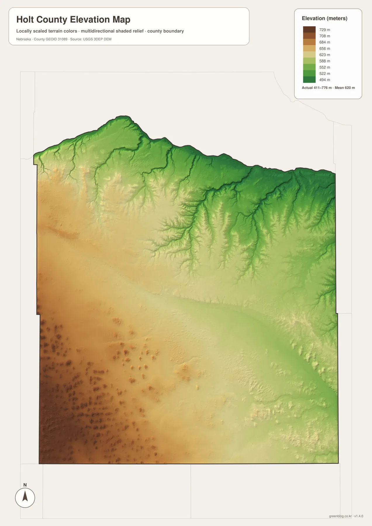
The elevation surface is generalized for county-scale comparison. It should not be used as survey-grade elevation for a parcel, building site, drainage design, road grade, or engineering project. Those tasks require current high-resolution data from sources such as the USGS 3D Elevation Program and, where appropriate, professional field measurements. For regional study, classroom use, and understanding why streams and roads occupy particular corridors, the color ramp and shaded relief provide a clear and useful overview.
U.S. 275 and U.S. 281 explain why O’Neill works as a county-wide reference point
Holt County’s size makes the numbered highways especially useful for orientation. U.S. 20 crosses the central part of the county through Stuart, Atkinson, and Emmet before reaching O’Neill. U.S. 281 runs north–south through O’Neill, while U.S. 275 approaches from the southeast and shares part of the corridor toward its O’Neill terminus. The combination places O’Neill at a natural crossroads between western communities, eastern communities, and routes leading outside the county. The road pattern is one reason the town is easier to use as a reference point than a settlement located near an outer boundary.
East of O’Neill, the U.S. 20 and U.S. 275 corridors connect with the road network serving Page, Inman, Ewing, and nearby rural areas. Nebraska Highway 95 runs near Chambers, helping define the southern part of the county, while Highway 11 is visible toward the southwest. Numerous smaller roads fill the spaces between those corridors, but the county map does not claim to show every current local-road condition. For travel planning, it is best used to understand the large framework first and then paired with up-to-date state transportation or navigation information.
The highways also make more sense when compared with terrain. Much of U.S. 20’s central route lies close to the Elkhorn River lowland rather than across the highest southwestern terrain. Around O’Neill, several roads converge where the valley provides a broad east–west corridor. Chambers, in contrast, lies away from the main Elkhorn stem and depends more on Highway 95 and connecting north–south roads for regional orientation. The map therefore shows that “the main road” depends on which part of Holt County a traveler is trying to understand.
Start with rivers and towns before trying to memorize Holt County’s boundary
The county outline can be difficult to remember because its north side bends while the south and west are more regular. A simpler method is to find the Niobrara River first, then locate O’Neill and the Elkhorn River in the middle. From O’Neill, Atkinson and Stuart establish the western direction, Chambers marks the south, and Ewing provides an eastern reference. Once those landmarks are in place, the administrative line becomes much easier to interpret because it can be related to features that already have recognizable names and shapes.
The same approach helps when looking beyond the county. The Niobrara valley defines much of the side facing Boyd County, while the northwest reaches toward Keya Paha County and the west faces Rock County. Sandhills terrain continues toward Loup County in the southwest and Garfield and Wheeler counties to the south. The Elkhorn River and major roads continue east toward Antelope and Knox counties. Natural features do not stop at an administrative border, so the county line is best treated as a location framework rather than a physical wall in the landscape.
Switching between maps reinforces that idea. Find O’Neill and U.S. 20 on the county map, then locate the same area beside the Elkhorn River on the water map and within the lower green corridor on the elevation map. In the southwest, use Chambers or the named lakes as location clues and compare them with the brown uplands. Along the north, pair the Niobrara River with the irregular boundary and deeply cut tributary valleys. Repeating that process at a few points builds a much stronger mental picture than studying any single map in isolation.
Choose the Holt County map that matches the question you are asking
For towns, roads, neighboring counties, and administrative orientation, the general county map is the best starting sheet. It keeps O’Neill, Atkinson, Stuart, Chambers, Inman, Ewing, Page, Emmet, the county boundary, and the major numbered roads in one view. The city-distribution map is more focused. By reducing background information and ranking the six larger communities, it quickly communicates how far the principal settlement points are spread across western, central, southern, and eastern Holt County.
Use the terrain-and-water map when the Niobrara River, Elkhorn River, South Fork Elkhorn River, Dry Creek, Cache Creek, or the southern lakes are the main subject. It is particularly useful for distinguishing the northern boundary drainage from the central Elkhorn corridor. The elevation map answers a different question: where is the land higher or lower? Its 411–776 meter range makes the high southwestern Sandhills and the lower northern and eastern valleys easy to compare without requiring detailed topographic contour reading.
For a classroom project or regional comparison, a useful sequence is to identify towns and roads first, then add water and elevation. The position of U.S. 275 becomes more meaningful beside the Elkhorn valley, and the southern lakes make more sense when viewed within the higher Sandhills terrain. If labels need to be enlarged or the maps printed, the original JPG files in the download archive are preferable to the smaller WebP previews used on the page. These maps are general-reference products, so legal boundary work, flood decisions, surveying, live road conditions, and engineering design should rely on the latest authoritative sources.
Frequently Asked Questions
Where is the Holt County seat?
O’Neill is the county seat. The current Holt County government website lists its offices in O’Neill, and History Nebraska notes that the seat moved from Paddock to O’Neill after an 1879 election. On the map, O’Neill is also a practical geographic reference because U.S. 20 and U.S. 281 meet there, while U.S. 275 approaches from the southeast near the Elkhorn River corridor.
Do the Niobrara River and Elkhorn River follow the same part of Holt County?
No. The Niobrara River follows the northern edge of the county, while the Elkhorn River crosses the central part near the Stuart–Atkinson–O’Neill settlement corridor. A wide area of uplands and tributary valleys separates the two systems, which is why the water and elevation maps show distinct northern and central landscape patterns.
Can the 411–776 meter elevation range be used for surveying or construction?
No. The elevation map is a generalized county-scale surface intended to compare broad terrain, such as the high southwestern Sandhills and lower river valleys. Parcel design, drainage calculations, construction, road engineering, or surveying should use current detailed elevation data and professional measurements rather than this regional reference map.
Map File Information
The county, city-distribution, terrain-and-water, and elevation maps described on this page are available together in one ZIP file. It contains four original high-resolution JPG maps suitable for printing and detailed viewing.
- Included Files: County map, city-distribution map, terrain-and-water map, elevation map
- File Type: JPG files in a ZIP archive
Related Maps
Sources and references
These official and public sources provide additional context for Holt County government, county history, administrative boundaries, waterways, and elevation. The maps on this page are simplified for readable regional reference, so legal, engineering, and current-condition decisions should be checked against the original authoritative datasets and notices.
- Holt County, Nebraska official website – county overview and government information
- History Nebraska – Dividing Holt County – county size and county-seat history
- U.S. Census Bureau TIGER/Line – administrative boundary and geographic reference data
- USGS National Hydrography – river and stream data
- USGS 3D Elevation Program – elevation data
Green Map creates custom-edited map images using open geographic data sources such as geoBoundaries, Natural Earth, OpenStreetMap, and government open data. These maps are edited visual materials, not raw data files, and are provided for education, documents, presentations, and graphic reference.