Grant County occupies a broad stretch of the Nebraska Sandhills, with Hyannis serving as the county seat and Highway 2 carrying most of the county’s named communities across the northern half. Ashby, Hyannis, Duluth, and Whitman are separated by long reaches of ranch country, dune ridges, shallow lakes, and wetlands. Elevation is generally highest in the west and gradually lower toward the east, while the landscape remains strongly rippled by stabilized sand dunes throughout. High-resolution map files are available for download in the section below.
This page explains Hyannis and nearby places, Highways 2, 61, 209, and 217, South Branch Middle Loup River, named Sandhills lakes, and an elevation range of about 1,068 to 1,284 meters. The original high-resolution JPG versions of the supplied maps can also be downloaded together in a ZIP for printing, classroom use, or personal reference.
Table of Contents
Hyannis sits at the county’s central Highway 2 junction
Hyannis is the Grant County seat. The county’s official website says Grant County was established on March 31, 1887, and named for Ulysses S. Grant, the eighteenth president of the United States. The county site lists Hyannis, Ashby, and Whitman among its communities, while the supplied map also labels Duluth along the same east-west road corridor.
Hyannis lies near the middle of the county’s northern half, where Highway 2 meets a southbound route into the ranching interior. Ashby lies west, while Duluth and Whitman are east. The large empty spaces between those small settlements are an important part of the map, reflecting a county where ranches and open grassland occupy far more land than towns.
History Nebraska’s work on the Sandhill lake country says Hyannis was founded as the railroad arrived in the spring of 1887. Whitman first held the county-seat designation because of its early railroad position, but the line soon extended farther west and Hyannis became the more central station. A later election shifted county government to Hyannis.
Highway 2 links Ashby, Hyannis, Duluth, and Whitman across the Sandhills
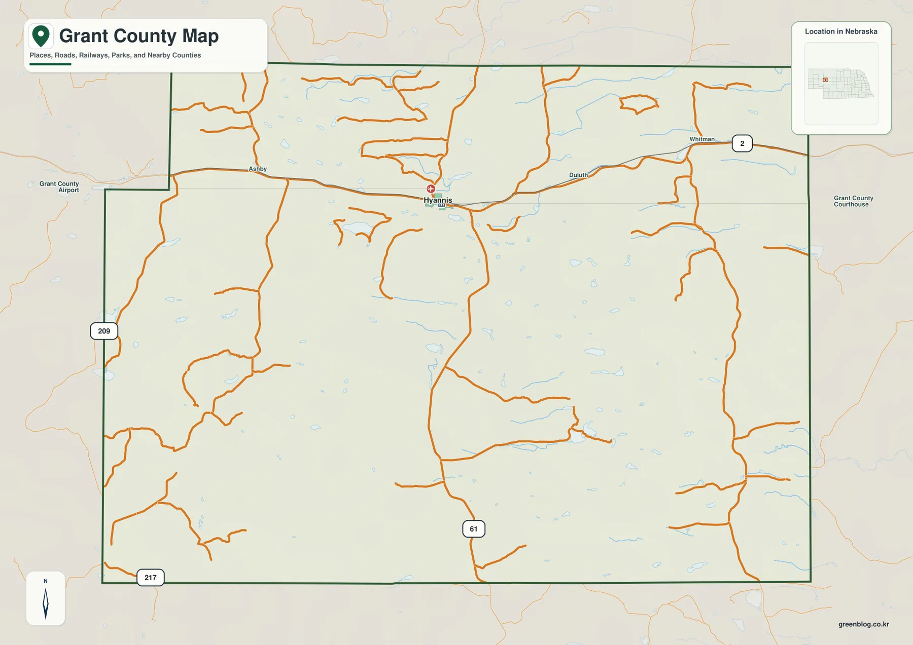
Nebraska Highway 2 is the county’s most important road and the easiest line to follow on the map. It enters near Ashby, passes through Hyannis, and continues through Duluth toward Whitman. The Nebraska Department of Transportation identifies this route as part of the Sandhills Journey National Scenic Byway, a 272-mile corridor through one of the state’s most distinctive landscapes.
At Hyannis, Route 61 extends south through the rural interior. Route 209 appears along the western side, and Route 217 marks part of the southwest. Most remaining orange roads are long local ranch routes rather than short urban streets, and their spacing becomes especially wide away from Highway 2.
The Sandhills terrain also affects road geometry. Long dune ridges, wet meadows, and lake basins interrupt a simple square grid, so some county roads bend or change direction around low ground. Drivers should verify road surface, winter conditions, construction, and closures with current Nebraska or local transportation information.
The city map contains only one ranked community: Hyannis
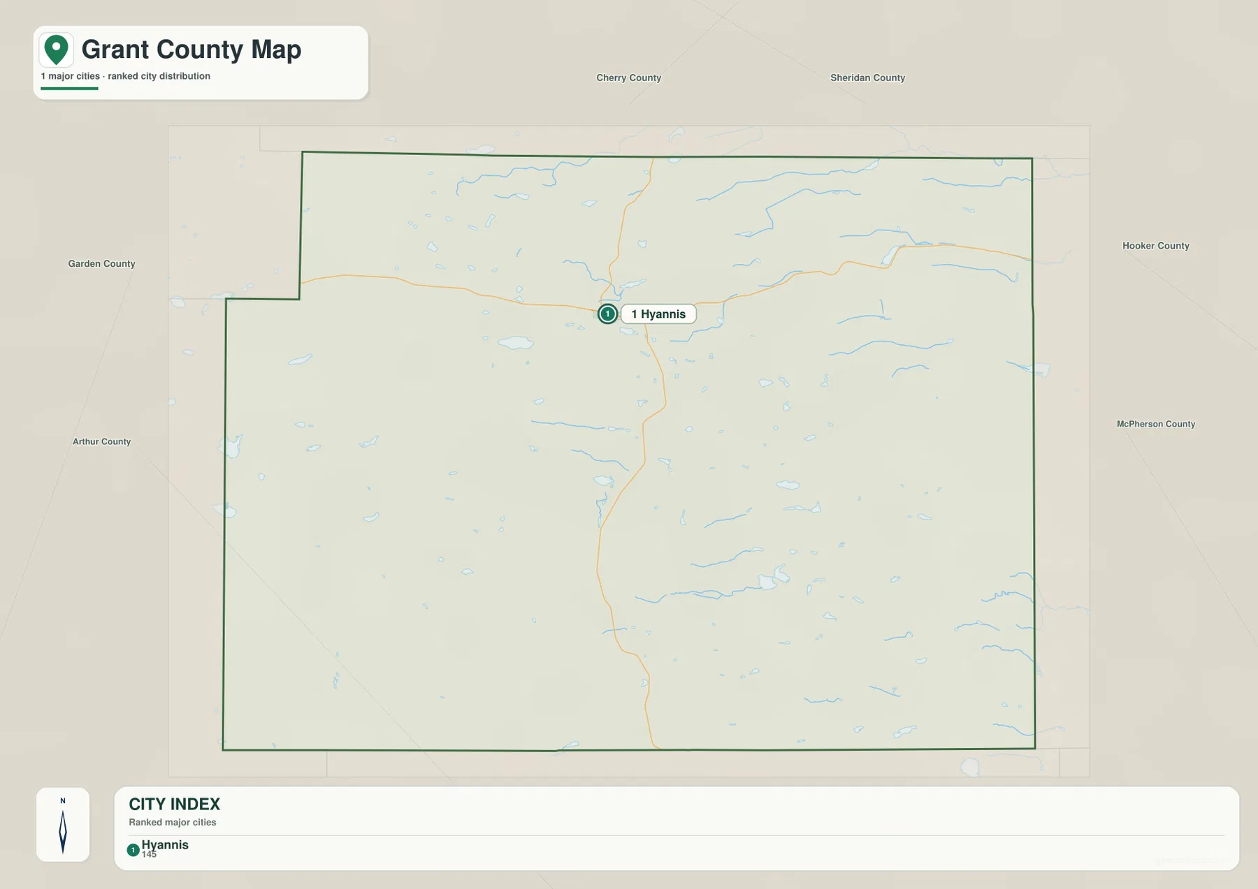
The supplied city distribution map ranks only Hyannis, with a printed value of 145. Ashby and Whitman appear on the general county map but do not appear in the ranked major-city index. This one-marker graphic is therefore a direct visual reminder of how lightly settled Grant County is.
Because no second ranked city appears, there are no connector lines or mileage labels. Hyannis is better understood by its position on Highway 2 and its relationship to Ashby and Whitman than by a city-to-city distance table. Route 61 provides the main reference for the much emptier southern interior.
The printed value of 145 belongs to the supplied ranking and should not be treated as a continuously updated population table. Current population counts and municipal status should be checked with the U.S. Census Bureau or current Grant County records when needed.
Small Sandhills lakes dominate the water map beyond the South Branch Middle Loup
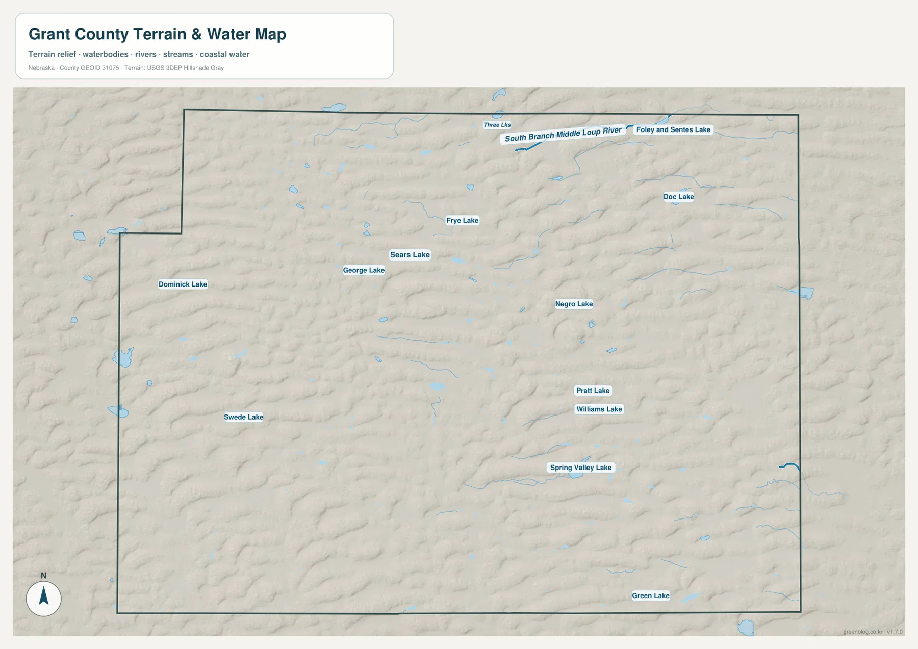
The water map is dominated by scattered lakes and wetlands rather than one large river. South Branch Middle Loup River crosses near the northern edge, with Three Lakes and Foley and Sentes Lake nearby. The river belongs to the broader Loup system, whose headwaters and tributaries are closely tied to groundwater moving through the Sandhills.
Dominick Lake, George Lake, Sears Lake, Frye Lake, and Swede Lake are spread across the western and central county. Farther southeast, Pratt Lake, Williams Lake, Spring Valley Lake, and Green Lake add another group of water bodies. The pattern is typical of the Sandhills, where shallow lakes and wetlands occupy lower basins between grass-covered dunes.
Nebraska Game and Parks notes that Sandhills wetlands are important areas of groundwater discharge and recharge and provide habitat for a wide range of birds and aquatic species. On the map, these lakes are not concentrated in one reservoir district; instead, they appear as individual blue patches scattered through the dune country.
This water map is intended for geographic reference. It does not define flood zones, legal water rights, parcel boundaries, present lake levels, water depth, fishing access, or navigability. Those questions require current information from USGS, Nebraska Game and Parks, or the responsible local agency.
Western dunes rise about 216 meters above the county’s lowest eastern ground
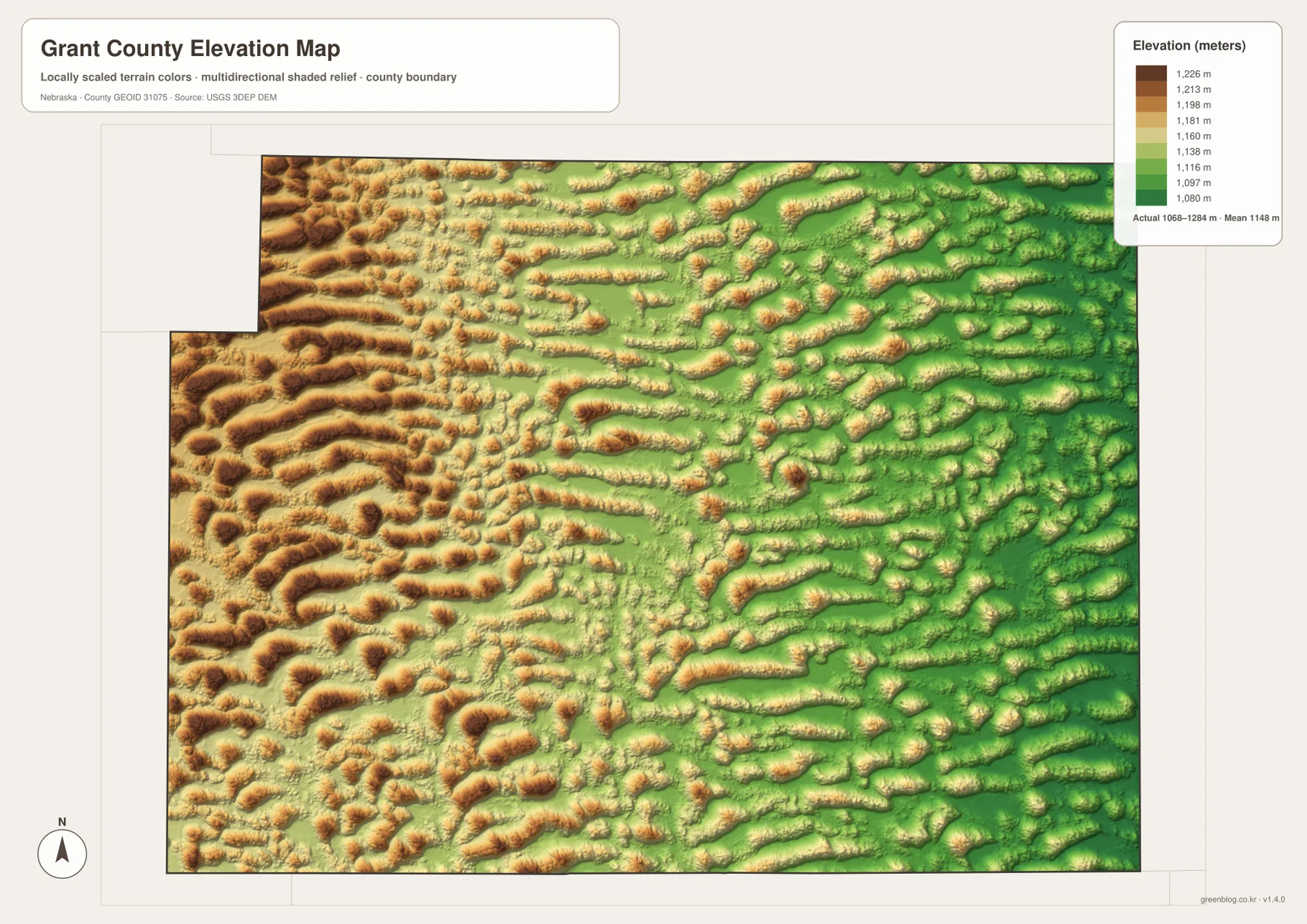
The elevation map reports an actual county-wide range of approximately 1,068 to 1,284 meters, with a mean near 1,148 meters. The highest brown terrain occupies much of the west and northwest, while the east contains more green. Total mapped relief is about 216 meters.
The most distinctive feature is not a single summit but hundreds of elongated dune ridges. Western Grant County contains closely spaced brown and orange ridges, while central areas mix higher crests with lower yellow-green swales. Eastern terrain is lower overall but remains strongly undulating rather than flat.
South Branch Middle Loup River and many of the mapped lakes occupy lower corridors or basins between dunes. This connection between relief and water becomes particularly clear when the elevation and water maps are compared: blue water bodies frequently sit in the greener low areas between higher dune crests.
The elevation colors are scaled locally for Grant County and should be used only for comparisons within this map. Similar shades on another county map may represent different absolute heights. The generalized surface is not survey-grade information for engineering, construction, drainage design, or property work.
County organization and the railroad reshaped the rivalry between Whitman and Hyannis
Grant County was organized in 1887, when ranching interests and local residents needed a functioning county government in a very sparsely settled Sandhills region. Nebraska county history also describes cattle rustling as a serious problem during this period, making local law enforcement one reason county organization mattered.
Whitman initially became the county seat because it was an established railroad point. As the railroad advanced westward, however, Hyannis became more centrally located. Hyannis won a county-seat election, and local history records a bitter dispute when representatives attempted to transfer the county records from Whitman. Hyannis ultimately became the permanent administrative center.
The Kinkaid Act reinforced a ranching landscape rather than a farm-town grid
The 1904 Kinkaid Act allowed much larger homestead claims in western Nebraska than the original Homestead Act. The Nebraska Association of County Officials says the new law brought many additional settlers into Grant County, but low rainfall and sandy soils made conventional crop farming difficult for many of them.
Ranching proved far better suited to the Sandhills. History Nebraska’s Abbott Ranch, established west of Hyannis in 1896, became one of the region’s prominent cattle operations and helps explain why Hyannis developed a strong ranching identity. The modern map still reflects that economy through long rural roads, large areas without towns, and a settlement pattern concentrated along Highway 2.
Use Hyannis and Highway 2 as the simplest orientation points
For basic orientation, start at Hyannis and follow Highway 2 west toward Ashby or east toward Duluth and Whitman. Then identify Route 61 heading south, Route 209 on the western side, and Route 217 in the southwest. Grant County Airport near the western side provides another useful landmark.
For physical geography, begin at South Branch Middle Loup River and move south through the scattered lake country. Comparing Three Lakes, Frye Lake, Sears Lake, Spring Valley Lake, and Green Lake with the elevation surface shows how water occupies lower basins between long Sandhills ridges.
The downloadable high-resolution JPG files are especially useful when county-road numbers or small lake names are difficult to read in the web previews. Starting with Hyannis and Highway 2, then comparing the water bodies with the west-to-east elevation change, gives a clear picture of Grant County’s unusual geography.
Frequently Asked Questions
Why does the city map show only Hyannis?
The supplied ranked-city map contains only Hyannis. Ashby and Whitman appear on the general map but are not included in the ranked major-city index, so the city map has no connector lines or distance labels.
Where is the highest terrain in Grant County?
The highest terrain is concentrated across the west and northwest. The mapped elevation range is about 1,068 to 1,284 meters, and terrain generally becomes lower toward the east. Lakes and wetlands often occupy lower basins between dune ridges.
Is Highway 2 part of a scenic byway?
Yes. Nebraska Highway 2 through Hyannis is part of the Sandhills Journey National Scenic Byway, a 272-mile route between Grand Island and Alliance. In Grant County it also serves as the main road connecting the county’s small communities.
Map File Information
The ZIP contains the original high-resolution JPG files for the Grant County boundary and road map, city distribution map, terrain and water map, and elevation map.
- Included Files: Use only the versions confirmed in the article and supplied images
- File Type: Use the confirmed download contents
- Intended Use: Printing, education, presentations, and map-based projects
Related Maps
Sources and references
- Grant County – About Our County
- Nebraska Association of County Officials – Grant County
- History Nebraska – Abbott Ranch
- Nebraska Department of Transportation – Scenic Byways
- Nebraska Game and Parks – Sandhills Wetlands
- USGS 3D Elevation Program
These maps are intended for geographic reference. For legal boundaries, land ownership, flood determinations, water rights, road conditions, construction, surveying, or other decisions requiring current authoritative information, consult Grant County and the responsible state or federal agency.
Green Map creates custom-edited map images using open geographic data sources such as geoBoundaries, Natural Earth, OpenStreetMap, and government open data. These maps are edited visual materials, not raw data files, and are provided for education, documents, presentations, and graphic reference.