Frontier County occupies a broad section of southwestern Nebraska, where Curtis and Stockville sit among high agricultural uplands cut by Medicine Creek and a dense network of smaller tributaries. The west and northwest are the highest parts of the county, while long creek valleys descend toward lower central and eastern terrain. Curtis, Maywood, Moorefield, Eustis, and Stockville are spread across the northern and central portions rather than forming one continuous urban corridor. High-resolution map files are available for download in the section below.
This page explains the main settlements and roads, the ranked distribution of five communities, Medicine Creek, Spring Creek, Muddy Creek, Dog Creek, and other waterways, plus an elevation range of about 698 to 955 meters. The original high-resolution JPG versions of the supplied maps can also be downloaded together in a ZIP for printing, classroom use, or personal reference.
Table of Contents
Stockville remains the county seat despite its very small size
Stockville is the Frontier County seat. History Nebraska records that the county was organized on January 17, 1872, during a period when stock raising dominated the local economy. Stockville was selected because it was one of the few settled places where public records could be maintained.
On the map, Stockville sits close to the geographic center of the county near Route 18 and several local roads. Curtis lies farther northwest and is much larger, but Stockville retained the county-seat role through multiple later relocation campaigns. The Nebraska Association of County Officials notes that the courthouse built in 1888 still stands there.
The county name reflects the same early history. Nebraska county records explain that the area represented part of the state’s southwestern frontier when it was organized. Agriculture and ranching later became firmly established, but the modern map still shows a sparsely settled county with small towns separated by long stretches of rural land.
Curtis and Stockville provide the clearest road references across the interior
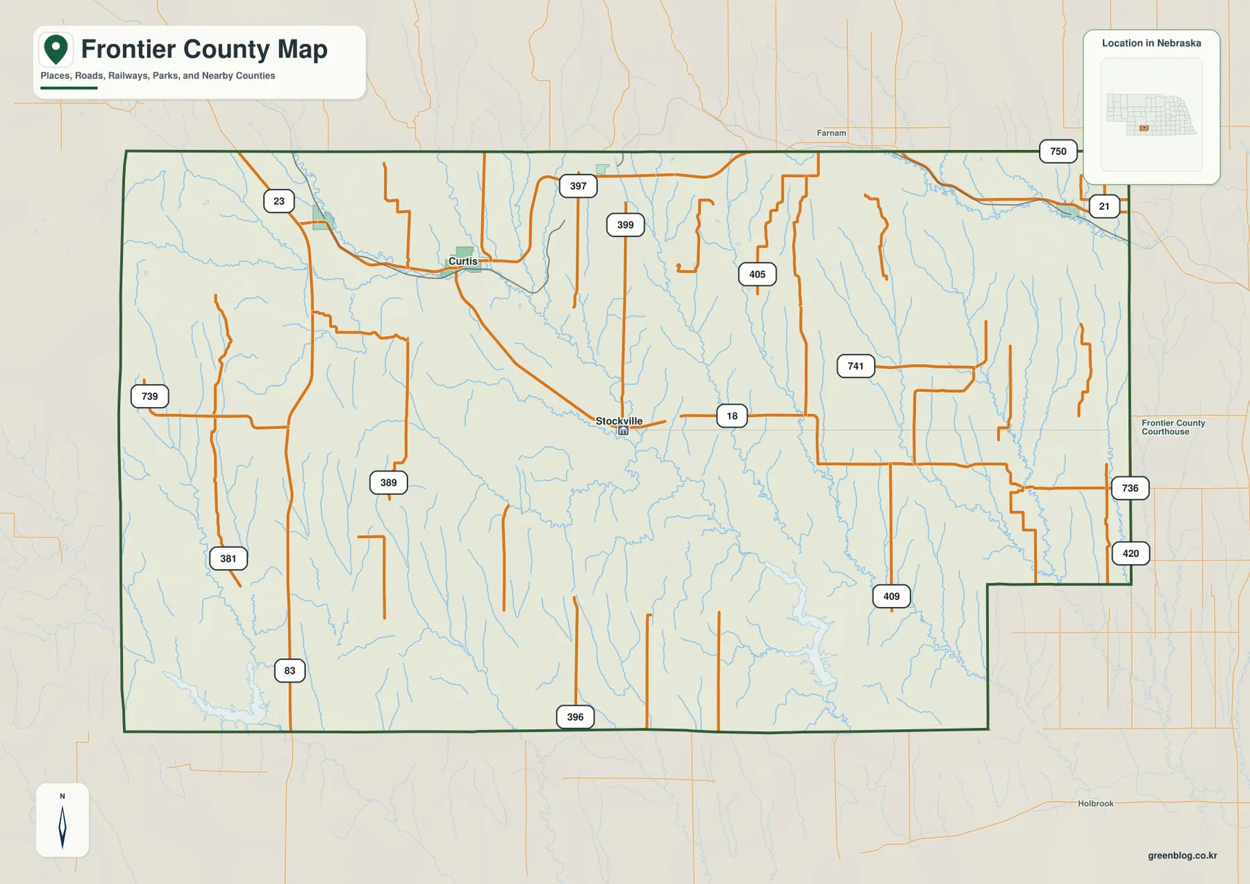
Curtis is the strongest road junction in the northwestern part of the county. Route 23 approaches from the northwest, while U.S. 83 runs north-south across the western side. Roads then extend southeast from Curtis toward the interior and connect with the Stockville area.
Route 18 leaves Stockville toward the east, and local roads numbered 389, 396, 397, 399, and 405 appear across the central area. On the eastern and northeastern side, routes marked 21, 420, 736, and 741 provide useful references near the Eustis side of the county. Roads 381 and 739 cross the western rural uplands.
The road network is less regular than a simple agricultural grid because creek valleys cut through much of the county. Central and eastern routes frequently bend around drainage lines and ridges, while the western uplands contain longer open sections. The map is useful for orientation, but current closures, construction, road surfaces, and travel times should be checked with live Nebraska transportation information.
Five ranked communities cluster across the northern and central county
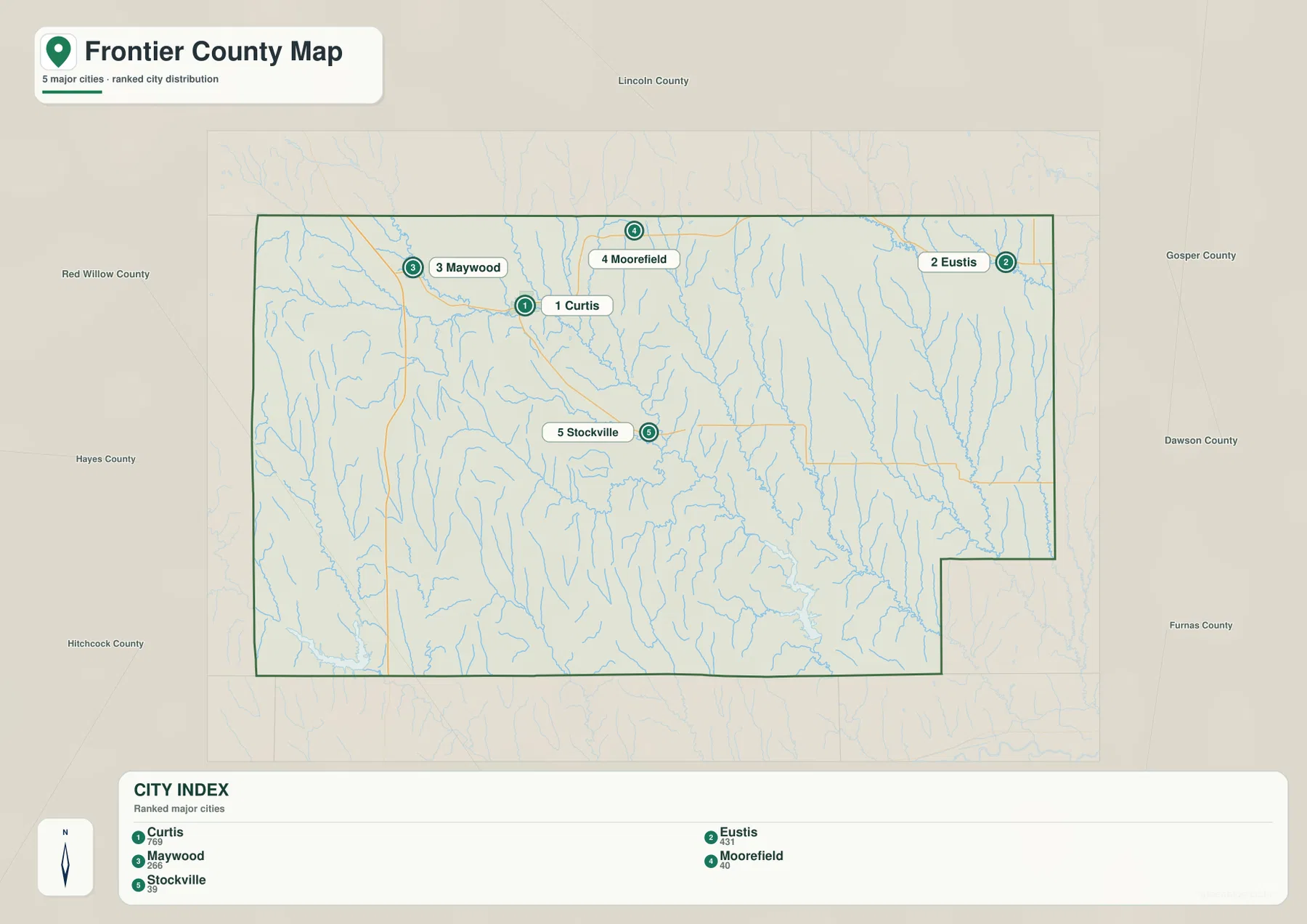
The city distribution map ranks Curtis first, followed by Eustis, Maywood, Moorefield, and Stockville. Curtis and Maywood lie in the northwest, Moorefield is north-central, Eustis occupies the northeastern side, and Stockville is near the middle. The five markers cover a broad area but remain concentrated north of the county’s southern half.
No connector lines or mileage labels appear on the supplied city map. The useful comparison is positional rather than numerical. Pairing it with the general road map makes it easier to see how Curtis and Stockville anchor the interior while Eustis and Maywood sit toward opposite ends of the northern settlement belt.
The values printed on the supplied city graphic are 769 for Curtis, 431 for Eustis, 266 for Maywood, 40 for Moorefield, and 39 for Stockville. They belong to the supplied ranking and should not be treated as a continuously updated population table. Current figures should be checked with the U.S. Census Bureau or other authoritative sources when needed.
Medicine Creek and Spring Creek cut long valleys through the interior
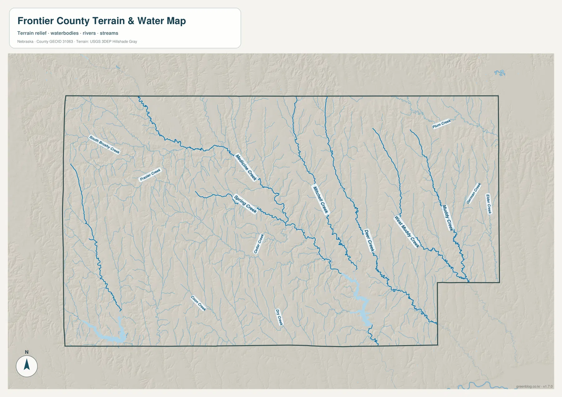
Medicine Creek is one of the strongest drainage lines on the western and central side. It descends southeast from higher ground, while South Brushy Creek and Frazier Creek cut additional valleys farther west. Spring Creek follows a similar southeastward course and creates another broad low corridor through the middle of the county.
Whittaker Creek and Dog Creek run south through the central-eastern interior. Farther east, West Muddy Creek and Muddy Creek form long parallel drainage lines, with German Creek and Elder Creek near the eastern boundary. Plum Creek crosses the northeastern corner and adds another branching tributary system.
Corn Creek and Dry Creek appear farther south, where many short tributaries descend from surrounding ridges. Frontier County therefore lacks one single dominant river through the middle; instead, numerous creeks divide the uplands into a repeating pattern of ridges and valleys.
This water map is intended for geographic reference. It does not define flood zones, legal water rights, parcel boundaries, current streamflow, channel depth, navigability, or public access. Those questions require current information from USGS and the responsible local or state agencies.
Western uplands rise more than 250 meters above the lowest creek valleys
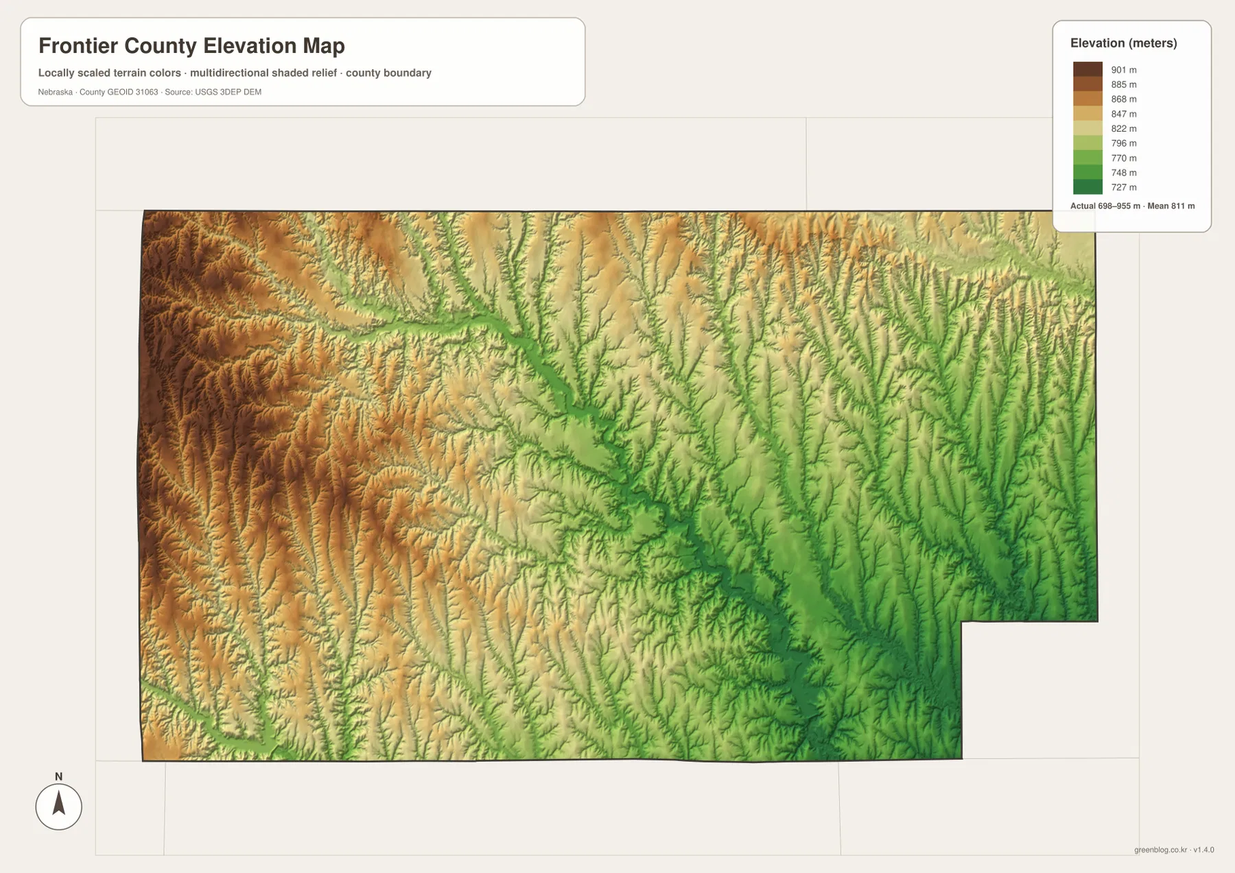
The elevation map reports an actual county-wide range of approximately 698 to 955 meters, with a mean near 811 meters. The highest brown terrain is concentrated across the west and northwest, while green terrain becomes increasingly common toward the center and east. Total relief is about 257 meters.
Medicine Creek and Spring Creek form long green corridors descending from the higher western country. Dog Creek and the Muddy Creek system cut even more deeply into the central and eastern uplands, and the lowest terrain becomes more widespread toward the southeastern side.
The west is not one flat plateau. Small tributaries carve the high surface into closely spaced ridges and valleys, although the overall elevation remains clearly higher than the east. Eastern Frontier County is lower on average but is also heavily dissected by Muddy, German, Elder, and related creeks.
The elevation colors are scaled locally for Frontier County and should be used to compare locations within this map. Similar shades on another county map may represent different absolute heights. The generalized surface is not survey-grade information for engineering, construction, drainage design, or property work.
Frontier County began as cattle country in 1872
History Nebraska describes the county’s early economy as strongly tied to stock raising. Ranchers supported formal county organization in 1872, and Stockville became the administrative center. Settlement remained relatively slow through the 1870s, when livestock operations still dominated much of the surrounding landscape.
Farming increased during the 1880s as settlers occupied lower and more fertile valleys. The Burlington and Missouri River Railroad then connected the county with larger markets, and several new townsites were created. Curtis grew rapidly during this railroad era, while Stockville kept the courthouse and county-seat designation.
Curtis became the county’s largest community and an agricultural education center
Curtis developed later than Stockville but grew quickly as a railroad town. Nebraska county history notes that its population expanded while Stockville remained much smaller, leading to repeated efforts to move the county seat. None met the required threshold, so Stockville continued to serve as the administrative center.
Curtis is also home to the University of Nebraska’s Nebraska College of Technical Agriculture. NCTA’s campus history says the school opened in 1913 as a regional agricultural high school and shifted into college-level technical agriculture education in 1965. That long educational role connects modern Curtis with the county’s continuing agricultural identity.
Use Curtis, Stockville, and Medicine Creek as three map anchors
For basic orientation, locate Curtis in the northwest and Stockville near the center, then extend outward toward Maywood, Moorefield, and Eustis. Routes 23, 83, and 18 provide the clearest numbered references, while Route 21 helps orient the northeastern side. The ranked city map offers a simplified view when minor roads are not needed.
For physical geography, start with Medicine Creek and Spring Creek, then move east through Whittaker and Dog creeks to West Muddy and Muddy creeks. The elevation map explains the same pattern by showing high brown uplands in the west and lower green valleys across the center and east.
For printing or classroom display, the downloadable high-resolution JPG files preserve more road numbers, creek names, and local relief detail than the web previews. The county map emphasizes roads and settlements, the city map summarizes five ranked communities, the water map shows the branching creek network, and the elevation map highlights the county’s strong west-to-east relief change.
Frequently Asked Questions
Does the city map show the distance between Curtis and Stockville?
No. The supplied city map ranks and locates Curtis, Eustis, Maywood, Moorefield, and Stockville, but it does not include connector lines or mileage. Use the road map for relative position and a current routing service when actual driving distance is needed.
Where is the highest terrain in Frontier County?
The highest terrain is concentrated across the west and northwest. The mapped elevation range is about 698 to 955 meters, with lower ground becoming more common toward the center and east. Major creek valleys are substantially lower than the surrounding uplands.
Why is Stockville still the county seat even though Curtis is larger?
Stockville was selected when Frontier County was organized in 1872 because it was an established place for maintaining public records. Curtis later grew much larger with the railroad, but repeated efforts to relocate the county seat did not meet the required voting threshold.
Map File Information
The ZIP contains the original high-resolution JPG files for the Frontier County boundary and road map, city distribution map, terrain and water map, and elevation map.
- Included Files: Use only the versions confirmed in the article and supplied images
- File Type: Use the confirmed download contents
- Intended Use: Printing, education, presentations, and map-based projects
Related Maps
Sources and references
- Nebraska Association of County Officials – Frontier County
- History Nebraska – Frontier County Historical Note
- History Nebraska – Stockville History
- Nebraska College of Technical Agriculture – Campus History
- USGS National Hydrography
- USGS 3D Elevation Program
These maps are intended for geographic reference. For legal boundaries, land ownership, flood determinations, water rights, road conditions, construction, surveying, or other decisions requiring current authoritative information, consult Frontier County and the responsible state or federal agency.
Green Map creates custom-edited map images using open geographic data sources such as geoBoundaries, Natural Earth, OpenStreetMap, and government open data. These maps are edited visual materials, not raw data files, and are provided for education, documents, presentations, and graphic reference.