Fillmore County lies in southeastern Nebraska, where Geneva sits near the center of a broad agricultural landscape crossed by small creek valleys and a regular rural road grid. Fairmont, Exeter, and Grafton form a northern settlement line, while Shickley, Milligan, Strang, and Ohiowa occupy the southern and eastern interior. Elevation is generally higher in the west and lower toward the east, with Turkey Creek and the West Fork Big Blue River drainage carving gentle but visible relief. High-resolution map files are available for download in the section below.
This page explains the locations of Geneva, Fairmont, Exeter, Shickley, Milligan, and Grafton, the main highway corridors, Turkey Creek and Big Blue drainage, and an elevation range of about 450 to 533 meters. The original high-resolution JPG versions of the supplied maps can also be downloaded together in a ZIP for printing, classroom use, or personal reference.
Table of Contents
Geneva sits close to the geographic center of the county
Geneva is the Fillmore County seat and occupies an unusually central position. The county’s official history says Fillmore County was established in 1856, formally organized in 1871, and named for President Millard Fillmore. History Nebraska records that an April 1871 organizational election selected a county-seat location near the geographic center, in the area that became Geneva.
On the modern map, Geneva is a practical reference for almost every direction. Fairmont lies to the north, Exeter northeast, Milligan east, and Shickley southwest. The City of Geneva identifies U.S. Highway 81 and Nebraska Highway 41 as its principal highway connections, reinforcing the city’s role as the county’s central road junction.
Fillmore County’s current official website lists Geneva, Fairmont, Ohiowa, Shickley, Exeter, Milligan, Grafton, and Strang among its cities and villages. Most appear on the supplied county map, so the area’s settlement pattern can be read as a series of small towns distributed around Geneva rather than one dominant river corridor.
U.S. 6 and U.S. 81 make Fairmont the northern road junction
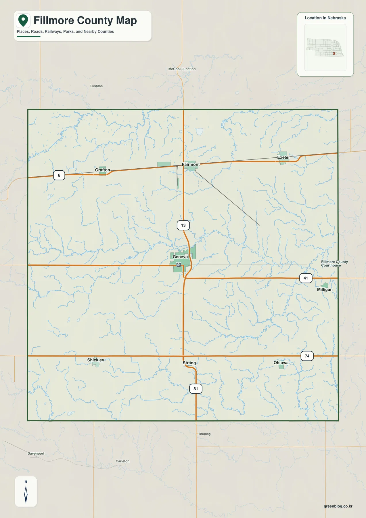
U.S. 6 is the clearest east-west route across the northern part of the county. It runs from Grafton through Fairmont toward Exeter and follows the same general corridor as the historic railroad. Fairmont therefore sits at an important northern junction where the east-west route meets the main north-south highway.
U.S. 81 continues south from Fairmont through Geneva toward Strang. Nebraska Highway 41 crosses the county through Geneva and Milligan, while Highway 74 serves the southern tier near Shickley, Strang, and Ohiowa. The towns are not all concentrated on one major river, so these intersecting road corridors provide the simplest framework for orientation.
Much of the rural road system follows a regular grid, but smaller stream valleys interrupt that pattern, especially across the eastern and southeastern half. The general map is useful for county-wide orientation, while current construction, closures, unpaved segments, and actual travel times should be checked with live Nebraska transportation information.
Six ranked communities show a balanced county-wide settlement pattern
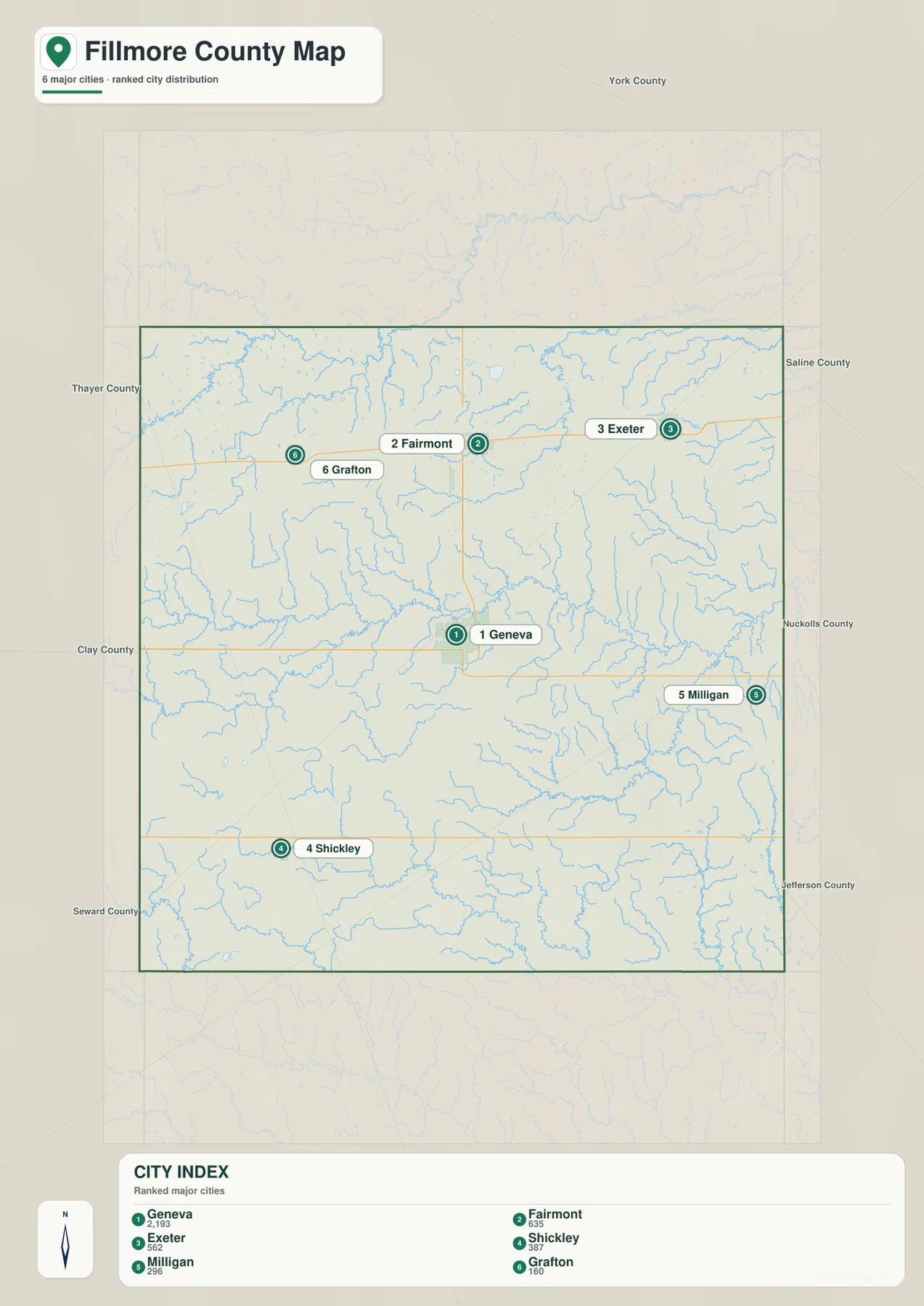
The city distribution map ranks Geneva first, followed by Fairmont, Exeter, Shickley, Milligan, and Grafton. Geneva is central, Fairmont and Exeter occupy the north, Shickley is southwest, Milligan east, and Grafton northwest. The six markers therefore span most of the county instead of clustering around a single edge.
No connector lines or mileage labels appear on the supplied city map. The useful comparison is positional rather than numerical. Pairing this view with the road map makes it easy to see that Fairmont, Exeter, and Grafton belong to the northern U.S. 6 corridor, while Shickley and Milligan sit on different southern and eastern routes.
The values printed on the supplied map are 2,193 for Geneva, 635 for Fairmont, 562 for Exeter, 387 for Shickley, 296 for Milligan, and 160 for Grafton. They belong to the supplied ranked-city graphic rather than a continuously updated demographic table. Current population figures should be checked with the U.S. Census Bureau or county sources when needed.
Turkey Creek divides the center while Big Blue drainage reaches the north
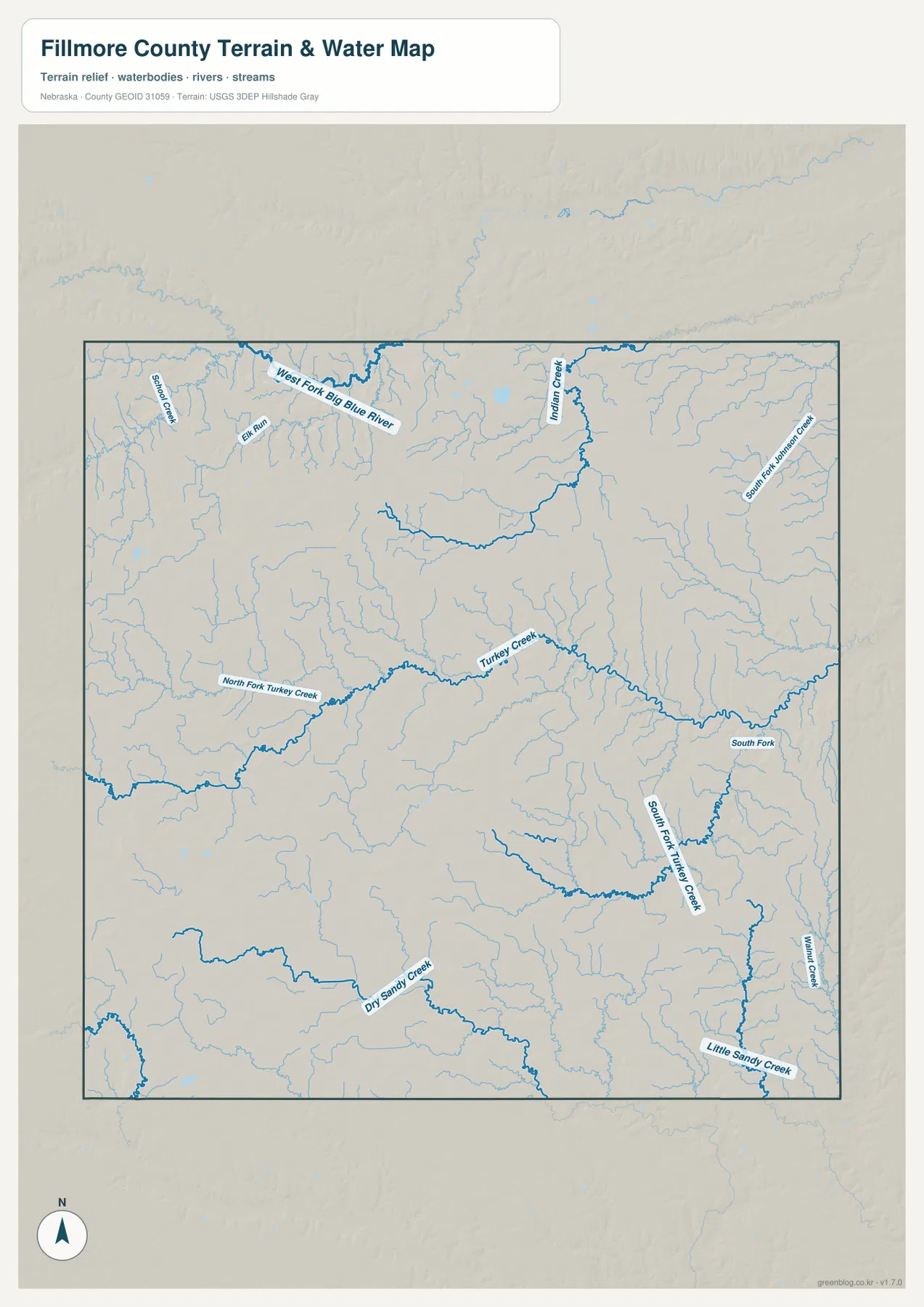
Turkey Creek is the strongest interior drainage line on the supplied water map. North Fork Turkey Creek descends from the west and joins the main channel, while eastern branches include South Fork and South Fork Turkey Creek. These channels create a long lower corridor through the central and southeastern agricultural landscape.
Across the north, West Fork Big Blue River reaches the county from the northwest and is joined by smaller features such as School Creek and Elk Run. Midland Creek and South Fork Johnson Creek occupy the northeastern side, where numerous tributaries create a more closely dissected surface than the higher western interior.
Dry Sandy Creek crosses part of the southern interior, while Walnut Creek and Little Sandy Creek appear farther southeast. The county therefore depends more on branching creek systems than on one large river running through its center. Those channels are small on a statewide map but strongly influence local relief.
This water map is intended for geographic reference. It does not define flood zones, legal water rights, parcel boundaries, current streamflow, channel depth, or public access. Those questions require current information from USGS and the responsible local or state agencies.
An 83-meter west-to-east drop shapes the county’s gentle relief
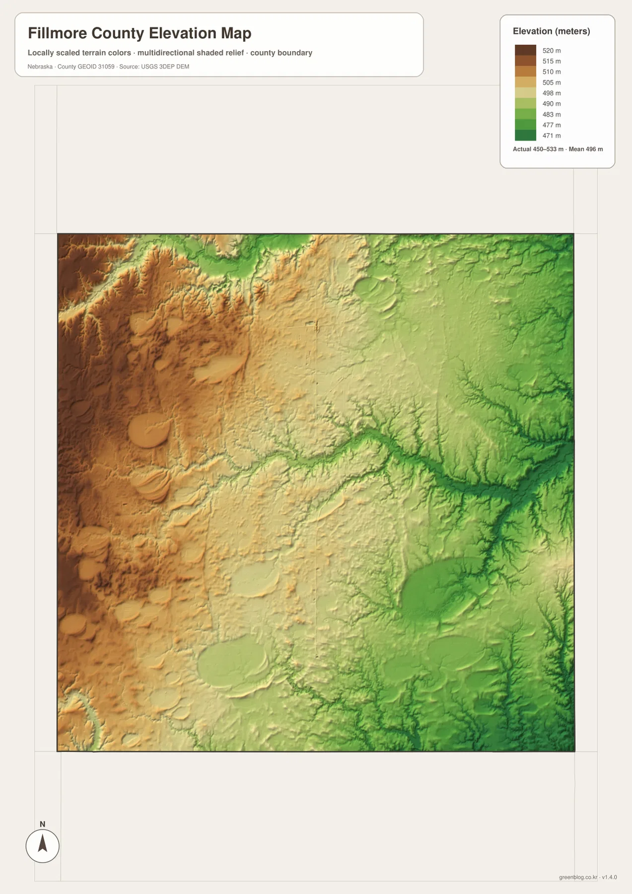
The elevation map reports an actual county-wide range of approximately 450 to 533 meters, with a mean near 496 meters. The highest brown terrain lies along the western side, including the northwest and southwest, while greens become more common toward the east. The overall relief is only about 83 meters, but the broad west-to-east slope is easy to see.
Turkey Creek creates a long lower corridor across the middle of the county, and West Fork Big Blue River and Midland Creek form additional low routes across the north. Little Sandy Creek and related southeastern drainage continue the same pattern toward the lower eastern edge.
The western side is not mountainous, but small tributaries cut the higher agricultural surface into low ridges and shallow valleys. Eastern Fillmore County is lower overall and more closely dissected by streams. The result is a landscape that looks broadly level from the road yet still contains persistent local relief.
The elevation colors are scaled locally for Fillmore County and should be used to compare locations within this map. Similar shades on another county map may represent different absolute heights. The generalized surface is not survey-grade information for engineering, construction, drainage design, or property work.
The 1871 county organization placed Geneva near the center
Fillmore County’s official history says the county was established in 1856 and formally organized in 1871. History Nebraska records that voters met on April 21, 1871, and chose a county-seat site near the geographic center. The location was initially associated with the name Henry, but it soon became Geneva.
The City of Geneva notes that the present Fillmore County Courthouse was completed in 1894 and stands prominently in the town square. Geneva’s central location and the crossing of U.S. 81 and Highway 41 still make it an obvious administrative hub despite its relatively small population.
Railroad routing shaped Exeter, Fairmont, and Grafton across the north
Settlement accelerated after the Burlington and Missouri River Railroad entered northern Fillmore County in 1871. The Nebraska Association of County Officials notes that the railroad shifted its planned route south from York County into Fillmore County, giving the county a stronger transportation advantage and encouraging rapid settlement.
History Nebraska’s account of the Burlington line says stations west of Crete were named in alphabetical sequence, including Dorchester, Exeter, Fairmont, and Grafton. The present map still preserves that history: Exeter, Fairmont, and Grafton appear in a clear east-west line along the modern U.S. 6 corridor.
Use Geneva and Turkey Creek as two simple map anchors
For basic orientation, start at Geneva and follow U.S. 81 north toward Fairmont or south toward Strang. Then use U.S. 6 to find Grafton and Exeter, Highway 41 to reach Milligan, and Highway 74 to locate Shickley and Ohiowa. The ranked city map provides a cleaner settlement view when minor roads are not needed.
For physical geography, begin with Turkey Creek through the center and trace its north and south forks before moving to West Fork Big Blue River in the north and Dry Sandy Creek in the south. The elevation map adds the vertical context by showing higher western ground and lower green valleys toward the east.
For printing or classroom display, the downloadable high-resolution JPG files preserve more road labels, creek names, and local relief detail than the web previews. The county map emphasizes roads and settlements, the city map summarizes six ranked communities, the water map shows the branching creek network, and the elevation map highlights the county’s gentle west-to-east drop.
Frequently Asked Questions
Does the city map show distances from Geneva to Fairmont or Exeter?
No. The supplied city map ranks and locates Geneva, Fairmont, Exeter, Shickley, Milligan, and Grafton, but it does not include connector lines or mileage. Use the road map for relative position and a current routing service when actual driving distance is needed.
Where is the lowest terrain in Fillmore County?
The eastern and southeastern creek valleys are generally the lowest parts of the county. The mapped elevation range is about 450 to 533 meters, with higher ground concentrated toward the west. Turkey Creek, Midland Creek, and Little Sandy Creek all follow lower terrain.
Why do Fairmont, Exeter, and Grafton form a northern line?
Their development was closely tied to the Burlington and Missouri River Railroad, which crossed northern Fillmore County in the early 1870s. Modern U.S. 6 follows the same general east-west corridor, so the railroad-era settlement pattern remains obvious on today’s map.
Map File Information
The ZIP contains the original high-resolution JPG files for the Fillmore County boundary and road map, city distribution map, terrain and water map, and elevation map.
- Included Files: Use only the versions confirmed in the article and supplied images
- File Type: Use the confirmed download contents
- Intended Use: Printing, education, presentations, and map-based projects
Related Maps
Sources and references
- Fillmore County – About Our County
- City of Geneva – Fillmore County
- History Nebraska – Fillmore County Historical Society
- History Nebraska – Burlington and Missouri River Railroad
- USGS National Hydrography
- USGS 3D Elevation Program
These maps are intended for geographic reference. For legal boundaries, land ownership, flood determinations, water rights, road conditions, construction, surveying, or other decisions requiring current authoritative information, consult Fillmore County and the responsible state or federal agency.
Green Map creates custom-edited map images using open geographic data sources such as geoBoundaries, Natural Earth, OpenStreetMap, and government open data. These maps are edited visual materials, not raw data files, and are provided for education, documents, presentations, and graphic reference.