Colfax County in eastern Nebraska is organized around two very different landscapes: the broad Platte River plain in the south and a more deeply dissected upland across the north and northwest. Schuyler sits in the southern lowland near U.S. 30 and the Union Pacific railroad, while Clarkson, Howells, and Leigh occupy the higher northern side. Shell Creek and the West and East forks of Maple Creek connect those uplands with the Platte corridor. High-resolution map files are available for download in the section below.
This page explains the county’s towns and roads, the Platte River and interior creek network, and an elevation range of roughly 396 to 529 meters. The original high-resolution JPG versions of the supplied maps are also available together in a ZIP for printing, classroom use, or personal reference.
Table of Contents
Schuyler occupies the low southern edge near the Platte River
Schuyler is the Colfax County seat and the strongest reference point on the map. The official county website lists Schuyler, Clarkson, Howells, Leigh, Richland, and Rogers as the county’s cities and villages. Schuyler is much larger than the other communities and sits in the south-central part of the county where U.S. 30, the railroad, and a major north-south road come together.
The Platte River runs along the southern side, creating a broad low plain around Schuyler and the U.S. 30 corridor. North and northwest of town, the land rises rapidly into rolling terrain cut by numerous creeks. The contrast is strong enough that the county can be understood almost immediately as a river lowland backed by higher creek-cut uplands.
History Nebraska records that Colfax County was created from Platte County on March 15, 1869, and named for Schuyler Colfax, then vice president of the United States. Schuyler, formerly known as Shell Creek Station on the Union Pacific Railroad, was designated the county seat. The city was incorporated in 1870.
U.S. 30 serves the Platte plain while Routes 91 and 57 organize the north
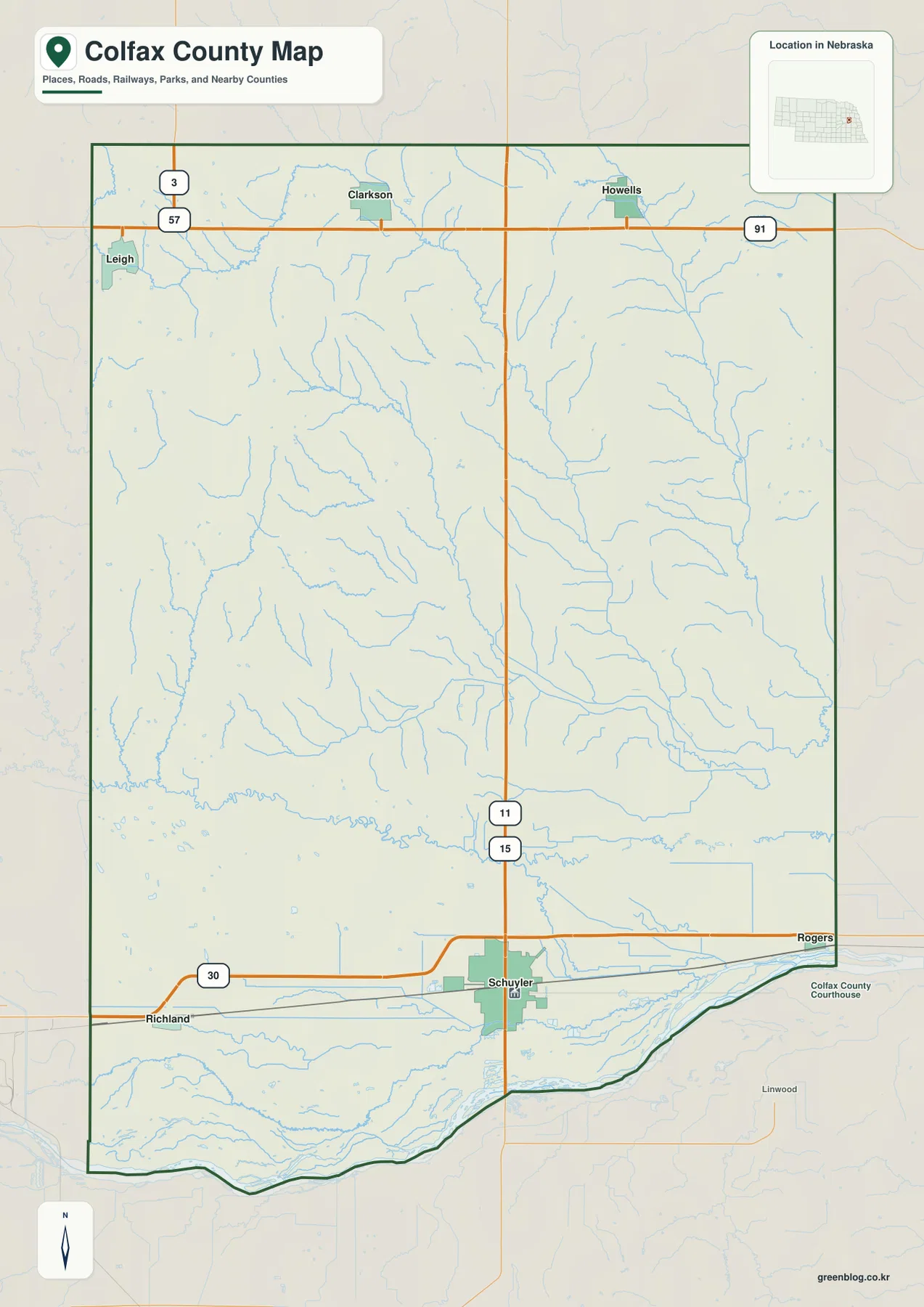
U.S. 30 is the clearest east-west road on the county map. It runs from Richland through Schuyler toward Rogers and follows the same southern corridor as the Union Pacific main line. Towns, railroad infrastructure, and the flattest land therefore cluster together along the Platte side of the county.
Across the north, Route 91 links the Clarkson and Howells area, while Route 57 provides an important reference near Leigh in the northwest. Route 15 runs north from Schuyler through the county interior. Colfax County’s comprehensive plan specifically identifies U.S. 30 and Nebraska Highways 15, 91, and 57 as principal routes.
Roads on the Platte plain are often long and direct, but the central and northwestern uplands contain many short tributary valleys that produce a more broken local road pattern. The general map is useful for county-wide orientation; current construction, closures, surface conditions, and travel time should be checked with live Nebraska transportation information.
The ranked city map separates Schuyler from the smaller northern towns
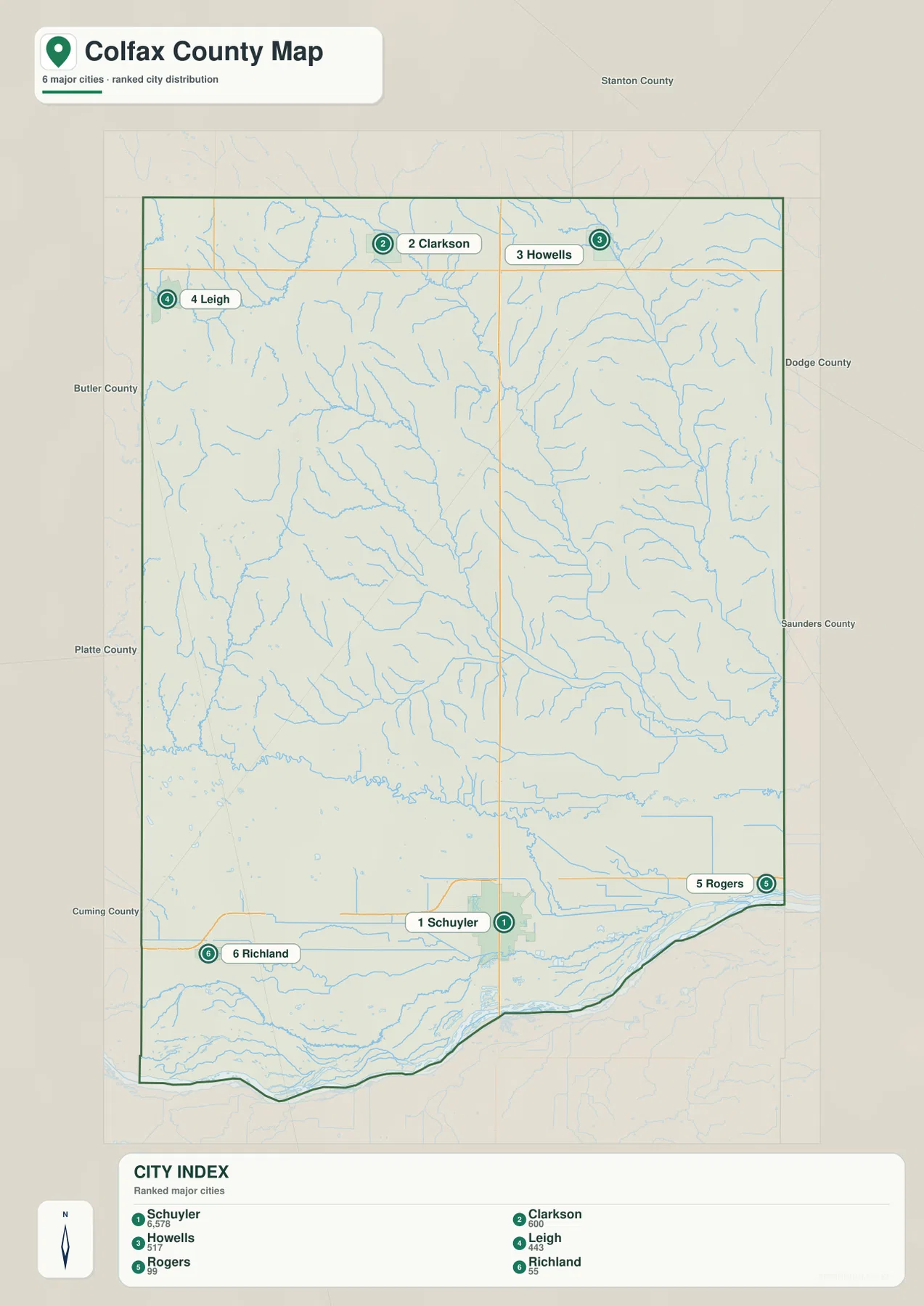
The city distribution map ranks Schuyler first, followed by Clarkson, Howells, Leigh, Rogers, and Richland. Schuyler is south-central, Clarkson and Howells sit in the north, Leigh is northwest, and Rogers and Richland occupy opposite sides of the U.S. 30 corridor. The six markers show a clear split between northern upland communities and settlements along the southern river plain.
No connector lines or mileage labels appear between the communities on the supplied city map. The useful comparison is therefore positional rather than numerical. The general road map is the better source for practical travel relationships, while the city view makes the settlement pattern much easier to compare at a glance.
The values printed on the supplied city map are 6,578 for Schuyler, 600 for Clarkson, 517 for Howells, 443 for Leigh, 99 for Rogers, and 55 for Richland. These are part of the supplied comparison graphic rather than a continuously updated demographic table. Current population figures should be checked with the U.S. Census Bureau or county sources when needed.
Shell Creek and the Maple forks cut long valleys through the uplands
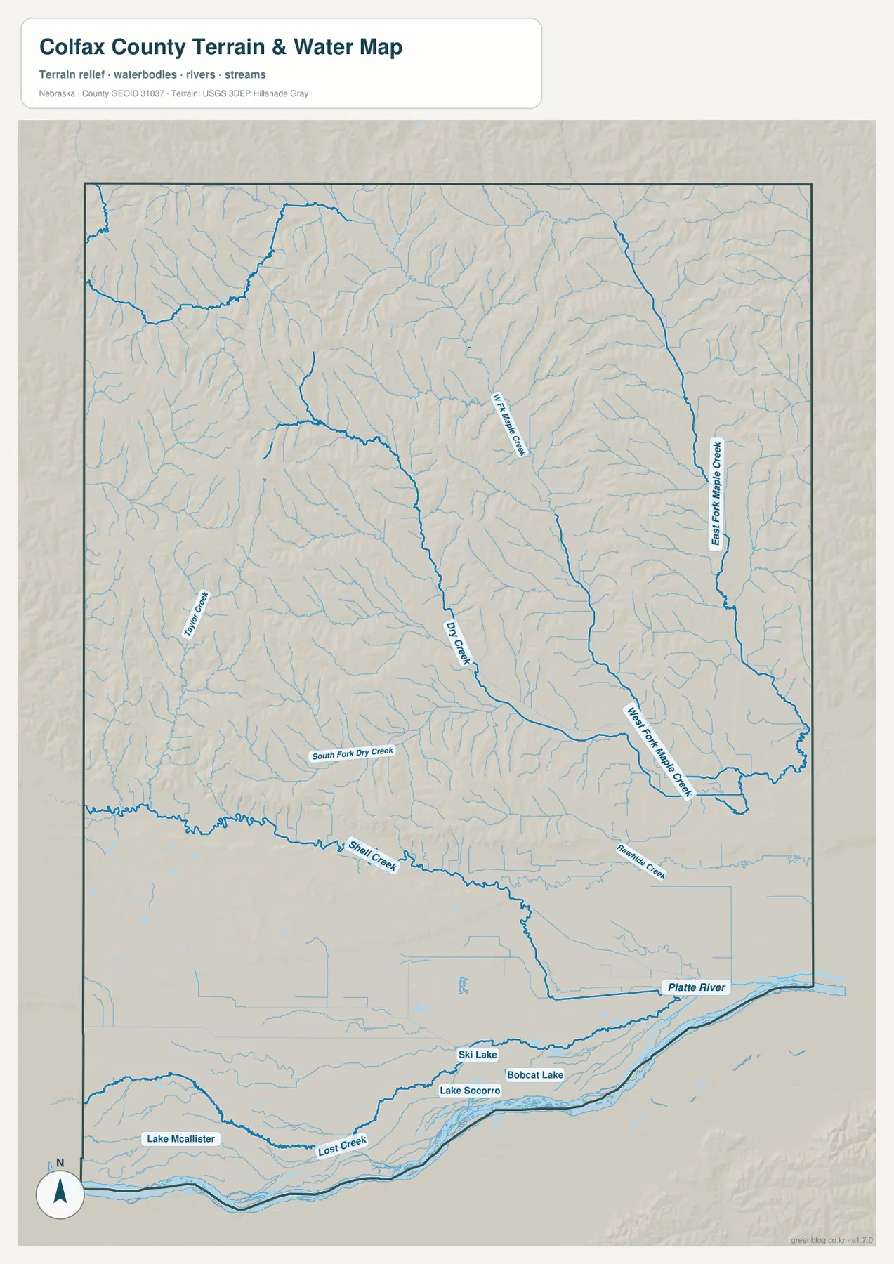
The Platte River is the largest water reference along the southern edge. Shell Creek and Lost Creek descend into the broad lowland around Schuyler, while a dense network of small channels crosses the river plain. The contrast between this flat southern drainage zone and the incised interior is one of the county’s strongest map features.
Dry Creek crosses the central interior on a long southeastward course. East of it, West Fork Maple Creek forms a broad valley, and East Fork Maple Creek follows another pronounced drainage farther east. The two Maple Creek branches are separated by narrow ridges and many smaller tributaries, producing a heavily dissected pattern across the eastern uplands.
Taylor Creek appears on the western side, while Rawhide Creek occupies the southeast before reaching the Platte corridor. Small lakes on the southern plain include Lake McAllister, Lake Socorro, Ski Lake, and Bobcat Lake. The county does not have a large lake system, but the mix of river, creek valleys, and small standing-water features gives the water map considerable local detail.
This water map is intended for geographic reference. It does not define flood zones, legal water rights, parcel boundaries, channel depth, navigability, or public access. Those questions require current information from USGS and the appropriate local or state agencies.
Elevation rises from the Platte plain into the northwest hills
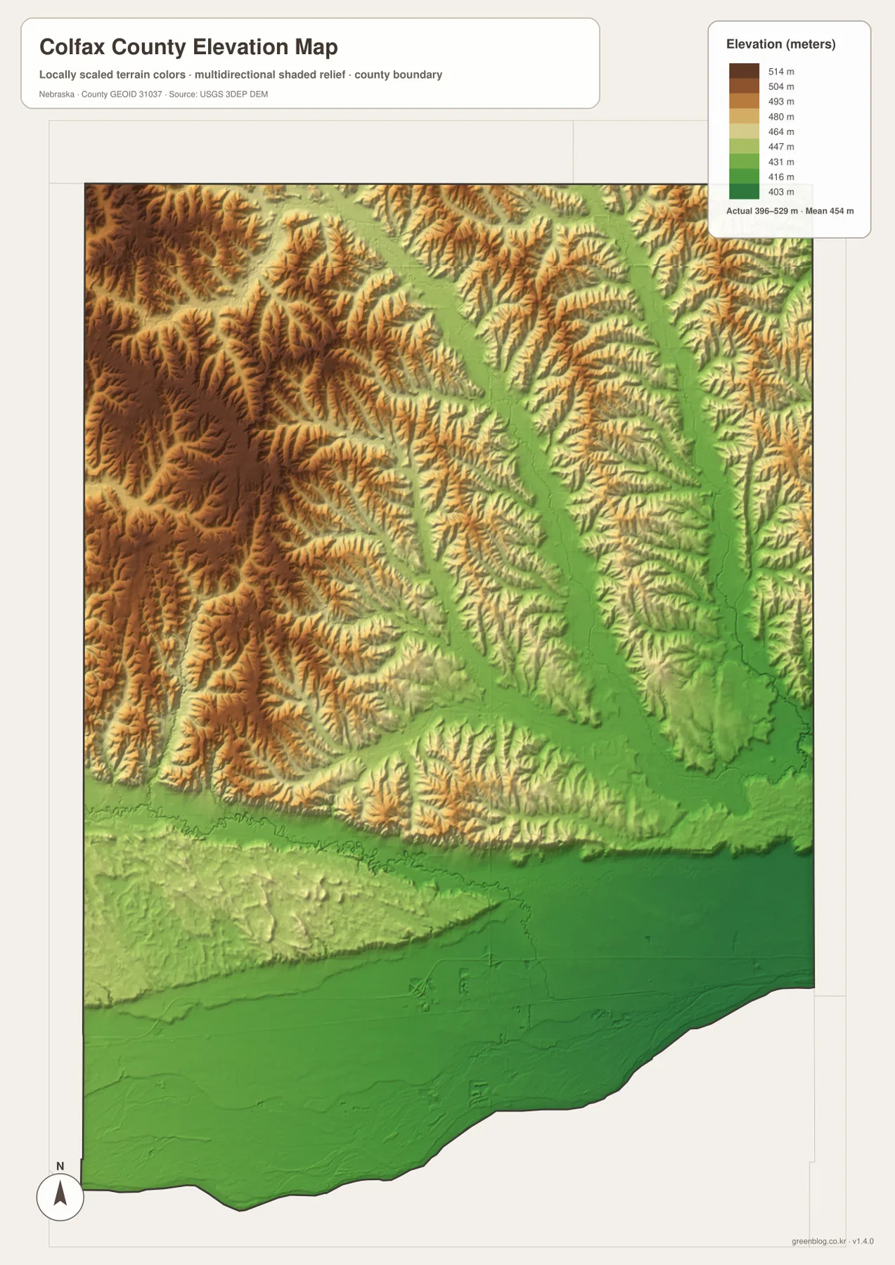
The elevation map reports an actual county-wide range of approximately 396 to 529 meters, with a mean near 454 meters. The lowest green terrain spreads across the Platte River plain in the south, including the Schuyler and Rogers area. Elevation increases quickly north of that lowland.
The highest brown terrain is concentrated in the west and northwest, particularly south of Leigh and west of Clarkson. Numerous short creek valleys cut into the uplands, so the surface looks strongly textured even though the total county-wide relief is only about 130 meters. The northwestern hills are therefore much more dissected than the broad southern plain.
West Fork and East Fork Maple Creek form long green corridors through the higher eastern interior, while Dry Creek produces another lower route closer to the center. Shell Creek leads into the Platte plain. Comparing the water and elevation maps makes the connection between named creeks and lower terrain especially clear.
The colors are scaled locally for Colfax County and should be used to compare places within this map. Similar shades on another county map may represent different absolute elevations. The generalized surface is not survey-grade information for engineering, construction, drainage design, or property work.
Schuyler grew from a railroad station on the Platte corridor
Colfax County’s comprehensive plan describes Schuyler as the community that developed from Union Pacific’s Shell Creek Station during the railroad’s westward construction in the 1860s. When the county was created in 1869, the site was selected as the county seat. The modern map still places the railroad, U.S. 30, Schuyler, and the broad Platte lowland in the same corridor.
History Nebraska records that the first county commissioners met on March 20, 1869, and the first courthouse was completed in 1872. Schuyler incorporated in 1870. The persistence of the same southern transportation and administrative center helps explain why the county’s largest city remains far larger than the smaller upland communities.
The Platte plain and creek-cut uplands form two recognizable county settings
A useful way to understand Colfax County is to separate the low southern Platte corridor from the uplands to the north. Schuyler, Richland, and Rogers are associated with the flatter southern side, while Clarkson, Howells, and Leigh sit closer to higher, more rolling terrain. The city pattern therefore reflects both transportation history and physical geography.
The Maple Creek system ties those two settings together. Water from the northern and eastern uplands follows West Fork and East Fork Maple Creek toward lower country, while Dry Creek and Shell Creek create additional routes into the Platte plain. Using the creek valleys as reference lines makes the interior road and settlement pattern easier to understand.
Using the four Colfax County map views together
For basic orientation, start with Schuyler and U.S. 30, then move west to Richland and east toward Rogers. Route 15 provides the main northward reference, while Routes 91 and 57 help organize Clarkson, Howells, and Leigh across the northern side.
For physical geography, begin with the Platte River and Shell Creek in the south, then trace Dry Creek and the two Maple Creek forks into the interior. The elevation map adds the vertical context by showing the Platte plain in green and the northwestern uplands in tan and brown.
For printing or classroom display, the downloadable high-resolution JPG files preserve more road labels and creek detail than the web previews. The county map emphasizes roads and settlements, the city map summarizes the six ranked communities, the water map identifies the creek network, and the elevation map highlights the contrast between the southern lowland and higher northwest.
Frequently Asked Questions
Does the city map show distances from Schuyler to Clarkson or Howells?
No. The supplied city map ranks and locates Schuyler, Clarkson, Howells, Leigh, Rogers, and Richland, but it does not include connector lines or mileage. Use the general road map for relative position and a current routing service when actual driving distance is needed.
Where is the lowest terrain in Colfax County?
The Platte River plain along the southern side is the lowest broad area. The county-wide elevation range is about 396 to 529 meters, with higher and more dissected terrain becoming common toward the west and northwest.
Why are Schuyler, U.S. 30, and the railroad concentrated in the south?
The southern Platte corridor provides a broad, low route compared with the creek-cut uplands farther north. Union Pacific established Shell Creek Station there, Schuyler grew around it, and today’s U.S. 30 and railroad continue to use the same general transportation corridor.
Map File Information
The ZIP contains the original high-resolution JPG files for the Colfax County boundary and road map, city distribution map, terrain and water map, and elevation map.
- Included Files: Use only the versions confirmed in the article and supplied images
- File Type: Use the confirmed download contents
- Intended Use: Printing, education, presentations, and map-based projects
Related Maps
Sources and references
- Colfax County official website
- Colfax County Comprehensive Plan
- History Nebraska – Colfax County Historical Note
- U.S. Census Bureau TIGER/Line Shapefiles
- USGS National Hydrography
- USGS 3D Elevation Program
These maps are intended for geographic reference. For legal boundaries, land ownership, flood determinations, water rights, road conditions, construction, surveying, or other decisions requiring current authoritative information, consult Colfax County and the responsible state or federal agency.
Green Map creates custom-edited map images using open geographic data sources such as geoBoundaries, Natural Earth, OpenStreetMap, and government open data. These maps are edited visual materials, not raw data files, and are provided for education, documents, presentations, and graphic reference.