Cedar County occupies Nebraska’s northeastern border, with Hartington near the center and a long Missouri River boundary along the north. Laurel and Randolph anchor the south, Wynot and Fordyce sit farther north, and a dense network of Bow Creek tributaries cuts the rolling interior. The terrain rises markedly toward the southwest, creating a strong contrast with the low river corridor. High-resolution map files are available for download in the section below.
This page explains the county boundary and road network, the ranked distribution of six major communities, the Missouri River and Bow Creek drainage, and an elevation range of about 344 to 588 meters. The original high-resolution JPG versions of the supplied maps are also available together in a ZIP for printing, classroom use, or personal reference.
Table of Contents
Hartington provides a central reference in a long north-south county
Hartington is the Cedar County seat and the easiest place to begin reading the map. The official county website lists Hartington, Laurel, Randolph, Belden, Coleridge, Fordyce, Magnet, Obert, Saint Helena, and Wynot among the county’s communities. Hartington sits close to the middle, making it a practical reference between Laurel and Randolph in the south and Wynot and St. Helena toward the Missouri River.
The Missouri River forms the northern boundary opposite South Dakota. Dixon County lies to the east, while Knox and Pierce Counties are west and southwest and Wayne County borders the south. The northern edge follows broad river bends, while several other county lines are much straighter, giving the outline a clear contrast between natural and surveyed boundaries.
Cedar County’s official history and History Nebraska record that the county was organized on February 12, 1857. Early county seats included St. James and St. Helena, and Hartington became the permanent seat in 1885 because its central location was more convenient for residents. That historical choice is easy to understand on the modern map.
Roads from Hartington reach Laurel, Randolph, Wynot, and the Missouri edge
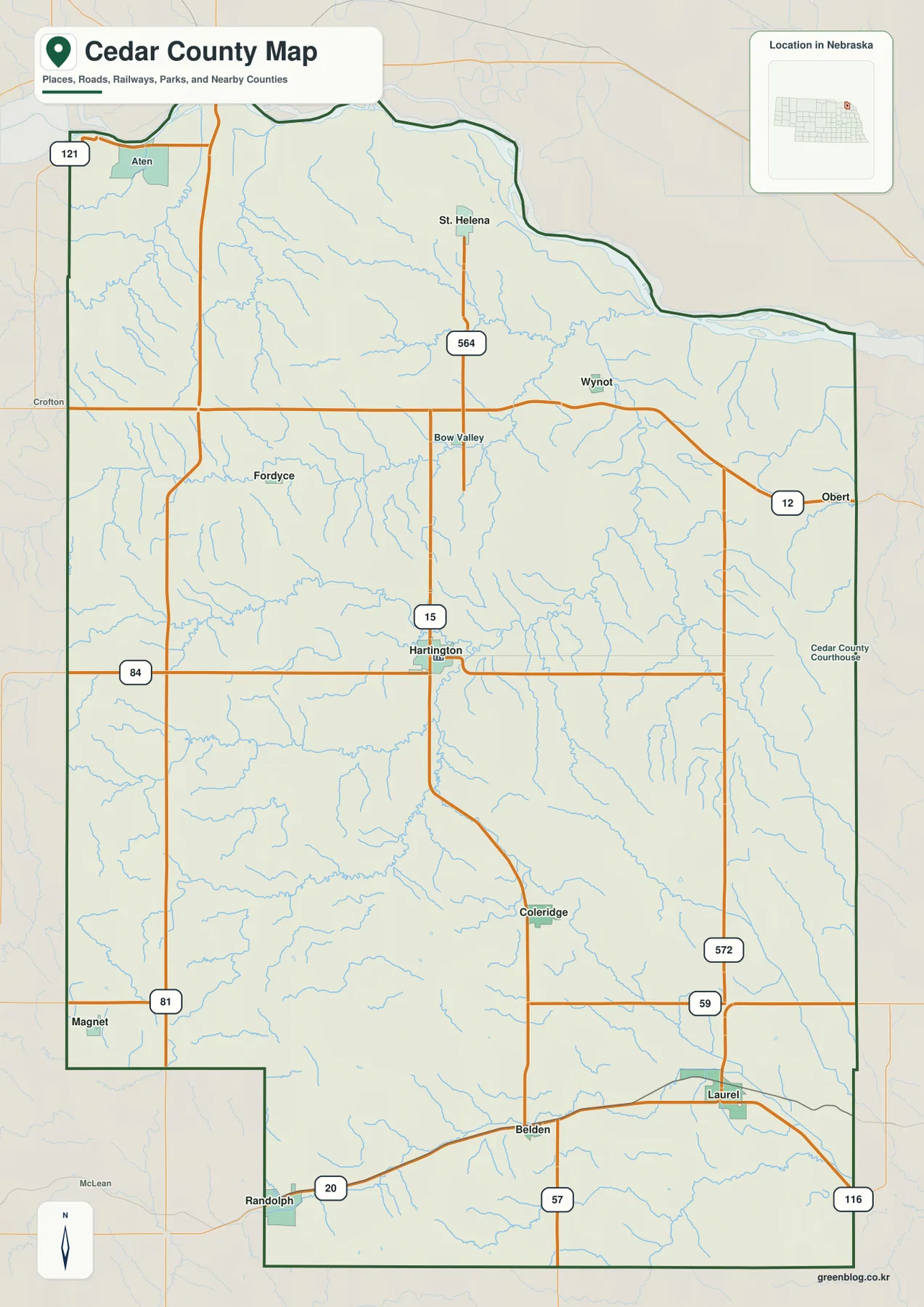
The road map is easiest to follow from Hartington, where routes marked 15 and 84 form strong north-south and east-west references. Bow Valley and Fordyce lie north of the county seat, with Wynot and St. Helena farther toward the Missouri River. These northern roads cross a more deeply dissected landscape than the broad agricultural areas farther south.
South of Hartington, the road network reaches Coleridge before splitting toward Laurel and Belden in the southeast and Randolph in the southwest. Routes marked 57, 59, and 116 appear around Laurel, while 20 and 81 help locate the Randolph side of the county. These roads show how the southern communities connect both to Hartington and to neighboring counties.
Routes marked 12 and 564 are visible around Wynot and St. Helena, and 121 appears near Aten in the northwest. The road pattern bends more frequently near the Missouri River and the steeper creek valleys. The map is useful for overall orientation, but current construction, closures, road surfaces, and driving times should be checked with live transportation information.
Six ranked communities span the county from Randolph to Wynot
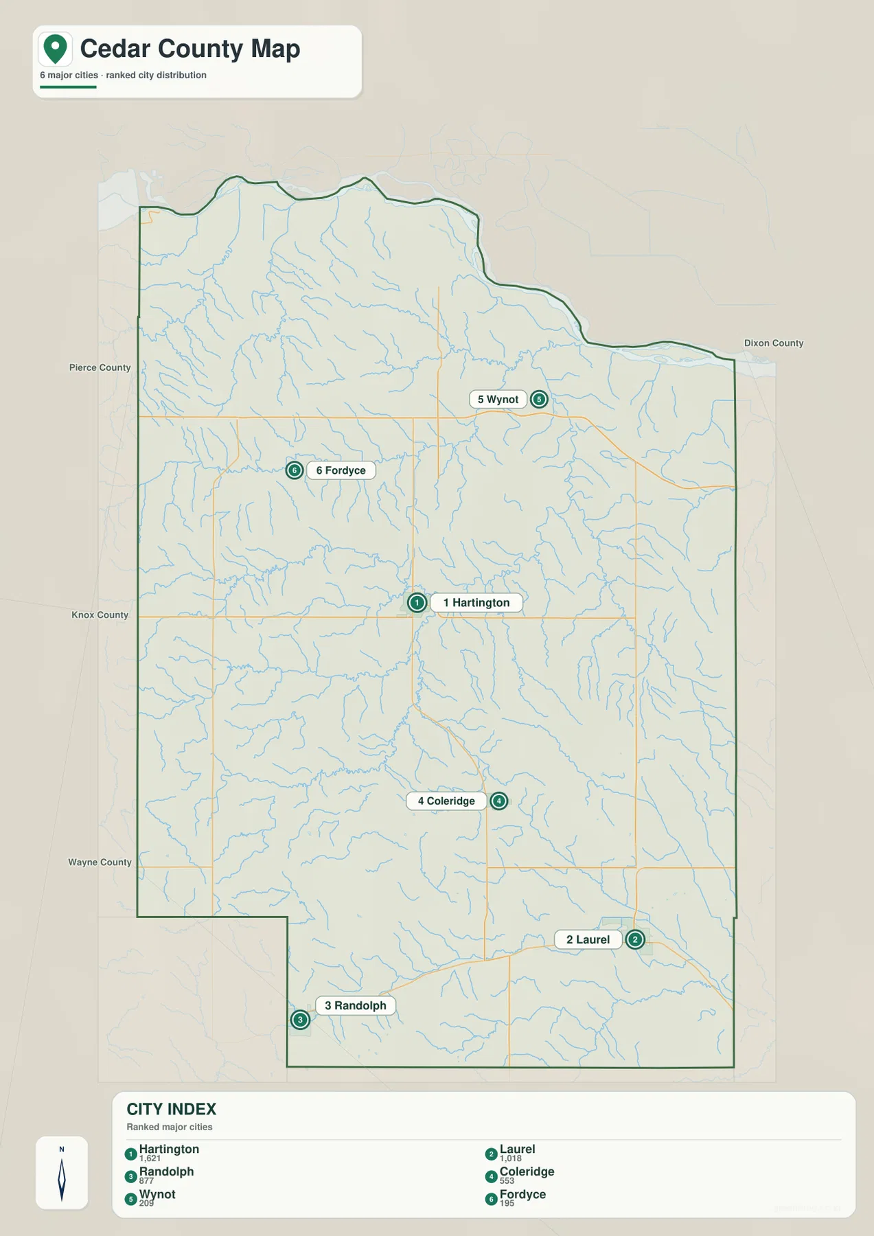
The city distribution map ranks Hartington first, followed by Laurel, Randolph, Coleridge, Wynot, and Fordyce. Hartington occupies the center, Laurel is southeast, Randolph southwest, Coleridge south-central, Wynot northeast, and Fordyce northwest. The six markers make the county’s long north-south settlement pattern easy to see.
No connector lines or mileage labels appear between the communities on the supplied map. The useful comparison is therefore positional rather than numerical. The general county map is the better source when practical travel relationships matter, while the city map removes minor roads and highlights the relative distribution of the main places.
The ranked values shown on the map are 1,621 for Hartington, 1,018 for Laurel, 877 for Randolph, 553 for Coleridge, 209 for Wynot, and 195 for Fordyce. Other communities such as Belden, Magnet, Obert, and Saint Helena are also listed by Cedar County but are not part of this six-place city index.
Bow Creek tributaries cut the interior below the Missouri River boundary
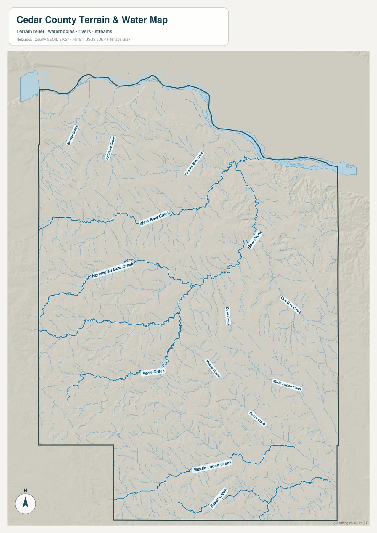
The Missouri River is the largest water reference, following the county’s northern edge. Immediately south of the river, short tributary valleys descend through the bluffs, including Beaver Creek, Antelope Creek, and Second Bow Creek. The river corridor is also the lowest broad zone on the elevation map.
West Bow Creek and Bow Creek dominate the central drainage pattern. West Bow Creek runs across the interior from the west, while Bow Creek descends from the northeast and connects with a network of smaller tributaries. Norwegian Bow Creek adds another long valley farther west, making the middle of the county a landscape of repeated creek corridors rather than one flat plain.
Pearl Creek is prominent farther south, with Middle Creek, Kerber Creek, North Logan Creek, and Prairie Creek crossing the southeastern interior. Middle Logan Creek and Baker Creek appear near the southern edge. The map shows many separate drainage lines instead of one major interior river, which helps explain the strongly dissected relief visible on the elevation view.
This water map is intended for geographic reference. It does not define flood zones, legal water rights, parcel boundaries, channel depth, navigability, or public access. Those questions require current information from USGS and the appropriate Nebraska or local agency.
Elevation climbs from the Missouri lowlands toward the southwest
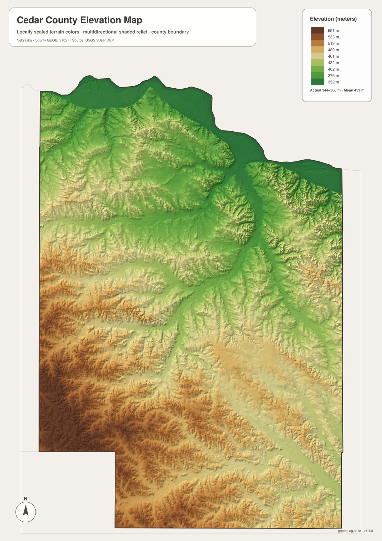
The elevation map reports an actual county-wide range of approximately 344 to 588 meters, with a mean near 453 meters. The lowest green terrain follows the Missouri River across the north, including the area north and east of Wynot. Elevation rises quickly away from the river as short ridges and valleys repeat through the northern interior.
The southwest contains the highest terrain, where broad brown and dark-brown uplands surround deeply cut creek valleys. The difference from the river corridor exceeds 240 meters across the county. Rather than one mountain mass, the higher country consists of rolling ridges separated by narrow drainages.
Bow Creek and West Bow Creek form long lower corridors through the central uplands, and Pearl Creek and Middle Logan Creek create similar green valleys farther south. East Bow Creek is also visible as a lower strip on the eastern side. Comparing the water and elevation maps makes the connection between named streams and terrain especially clear.
The colors are scaled locally for Cedar County and should be used to compare places within this map. Similar shades on another county map may represent different absolute elevations. The generalized surface is not survey-grade data for engineering, construction, drainage design, or property work.
Hartington’s central position explains its county-seat role
Hartington sits well south of the Missouri River lowland but does not extend into the highest southwestern terrain. Routes marked 15 and 84 meet there, giving the city direct connections toward both the northern and southern parts of the county. On the elevation map, it occupies a moderate interior setting between several creek valleys.
History Nebraska says Hartington was selected as the permanent county seat in 1885 largely because its central location improved access for county residents. The Cedar County Courthouse was built in 1891-1892 and remains a prominent local landmark. The modern road and city maps still reflect the same centrality that drove the nineteenth-century decision.
The Missouri River and early settlement shaped Cedar County’s history
Cedar County’s official history notes long-standing Omaha, Ponca, and Sioux presence in the region and records the Lewis and Clark Expedition traveling along the Missouri River in 1804. The county name came from the cedar groves found in the area. The Missouri remains the strongest natural boundary on the modern map and an important part of the county’s historical identity.
St. Helena once served as the county seat, while Wynot, Fordyce, Coleridge, Laurel, Randolph, and other small communities developed around agriculture and transportation. The present map still shows that dispersed rural structure, with towns separated by broad farmland and a dense network of creek valleys.
Using the four Cedar County map views together
For basic orientation, start with Hartington and the roads marked 15 and 84, then move south toward Coleridge, Laurel, and Randolph or north toward Fordyce and Wynot. The city map provides a simpler view of the same six major communities when settlement distribution is the main question.
For physical geography, begin at the Missouri River and move south through West Bow Creek, Bow Creek, and Norwegian Bow Creek before tracing Pearl Creek and Middle Logan Creek. The elevation map adds the vertical context by showing the river edge in green and the highest southwestern terrain in tan and brown.
For printing or classroom display, the downloadable high-resolution JPG files preserve more road labels and creek names than the web previews. The county map emphasizes roads and boundaries, the city map summarizes ranked communities, the water map identifies the creek network, and the elevation map shows the strong north-to-southwest relief change.
Frequently Asked Questions
Does the city map show distances from Hartington to the other communities?
No. The supplied city map ranks and locates Hartington, Laurel, Randolph, Coleridge, Wynot, and Fordyce, but it does not include connector lines or mileage. Use the general county map for relative position and a current routing service when actual driving distance is needed.
Where is the lowest terrain in Cedar County?
The Missouri River corridor along the northern boundary is the lowest broad area. The county-wide elevation range is about 344 to 588 meters, with higher terrain becoming more common toward the southwest. Bow Creek and other major creek valleys also appear lower than the surrounding ridges.
Can the water map be used for flood or property decisions?
No. It is a geographic reference showing the Missouri River, Bow Creek, West Bow Creek, Pearl Creek, Middle Logan Creek, and smaller tributaries. Flood risk, water rights, parcel boundaries, channel conditions, and access questions require current authoritative records.
Map File Information
The ZIP contains the original high-resolution JPG files for the Cedar County boundary and road map, city distribution map, terrain and water map, and elevation map.
- Included Files: Use only the versions confirmed in the article and supplied images
- File Type: Use the confirmed download contents
- Intended Use: Printing, education, presentations, and map-based projects
Related Maps
Sources and references
- Cedar County – About Our County
- History Nebraska – Cedar County Historical Marker
- U.S. Census Bureau TIGER/Line Shapefiles
- USGS National Hydrography
- USGS 3D Elevation Program
These maps are intended for geographic reference. For legal boundaries, land ownership, flood determinations, water rights, road conditions, construction, surveying, or other decisions requiring current authoritative information, consult Cedar County and the responsible state or federal agency.
Green Map creates custom-edited map images using open geographic data sources such as geoBoundaries, Natural Earth, OpenStreetMap, and government open data. These maps are edited visual materials, not raw data files, and are provided for education, documents, presentations, and graphic reference.