Brown County in north-central Nebraska is easiest to understand from Ainsworth, where U.S. 20 crosses the northern part of the county and several north-south roads meet. Long Pine lies to the east, Johnstown to the west, the Niobrara River follows much of the northern boundary, and the southern half opens into higher Sandhills terrain crossed by the Calamus River system.
This page explains the county boundary and road network, the straight-line city connections from Ainsworth, the main rivers and creeks, and the elevation contrast between the northern river valleys and higher Sandhills. The original high-resolution JPG map files are also available together in a ZIP for printing, classroom use, or personal reference.
Table of Contents
Ainsworth and U.S. 20 provide the clearest starting point
Ainsworth is the county seat and the strongest geographic reference on the map. Brown County Government is based there, and History Nebraska records that Brown County was organized in 1883 and that Ainsworth was selected as the permanent county seat at the county’s first election. The modern map reflects that role, with the largest concentration of major roads near the city.
Keya Paha County lies to the north, Rock County is east, Thomas County is southeast, and Loup County is southwest. Blaine and Cherry Counties appear toward the west. The northern boundary is particularly distinctive because a long portion follows the winding Niobrara River instead of a straight survey line.
U.S. 20 links Johnstown, Ainsworth, and Long Pine
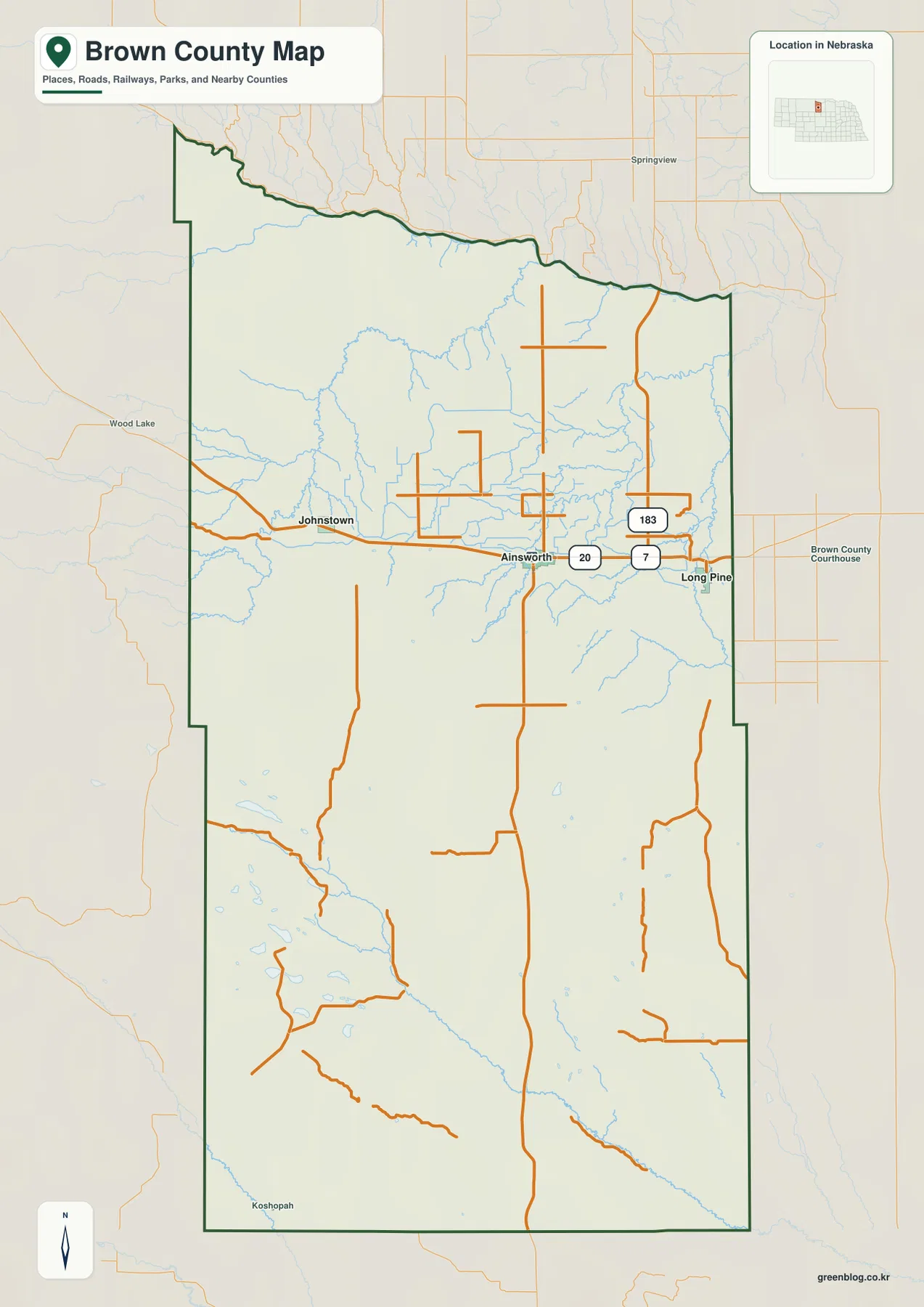
U.S. 20 is the most useful road to follow across the general map. It approaches from the west near Johnstown, passes through Ainsworth, and continues east toward Long Pine. The three principal communities therefore sit along one broad east-west transportation corridor in the northern half of the county.
Near Ainsworth, Nebraska Highway 7 and U.S. 183 provide north-south references. These roads connect the U.S. 20 corridor with rural areas closer to the Niobrara River and with the large Sandhills interior to the south. Around Long Pine, local roads branch into a more deeply cut creek landscape near the eastern side of the county.
Road spacing becomes much wider south of the U.S. 20 corridor. The southern Sandhills contain long rural segments between junctions, and roads often follow practical routes between ridges, wet depressions, and stream crossings. The county map is useful for orientation, but live road conditions, construction, and driving times should be checked separately.
Long Pine is 8 straight-line miles from Ainsworth, Johnstown 10
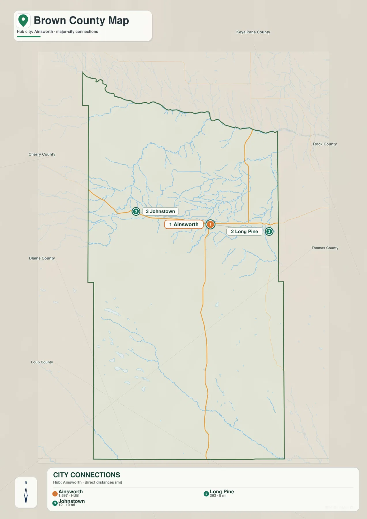
The city-connection map uses Ainsworth as the hub. It shows about 8 straight-line miles from Ainsworth to Long Pine and about 10 miles from Ainsworth to Johnstown. These are direct point-to-point measurements rather than road mileage, so actual driving distances depend on the route and the exact starting and ending locations.
Long Pine lies east of Ainsworth and Johnstown lies west, placing all three selected communities along the same general U.S. 20 corridor. The map ranks Ainsworth first, Long Pine second, and Johnstown third, making it a simple way to compare their relative positions without the additional detail of minor roads.
Long Pine also has a distinctive natural setting. Nebraska Game and Parks describes Long Pine State Recreation Area as a 153-acre tract straddling Long Pine Creek, with camping, hiking, fishing, and other outdoor activities. That creek-valley setting is clearly visible on the terrain and water map east of Ainsworth.
The Niobrara River defines the north while smaller creeks cut inland valleys
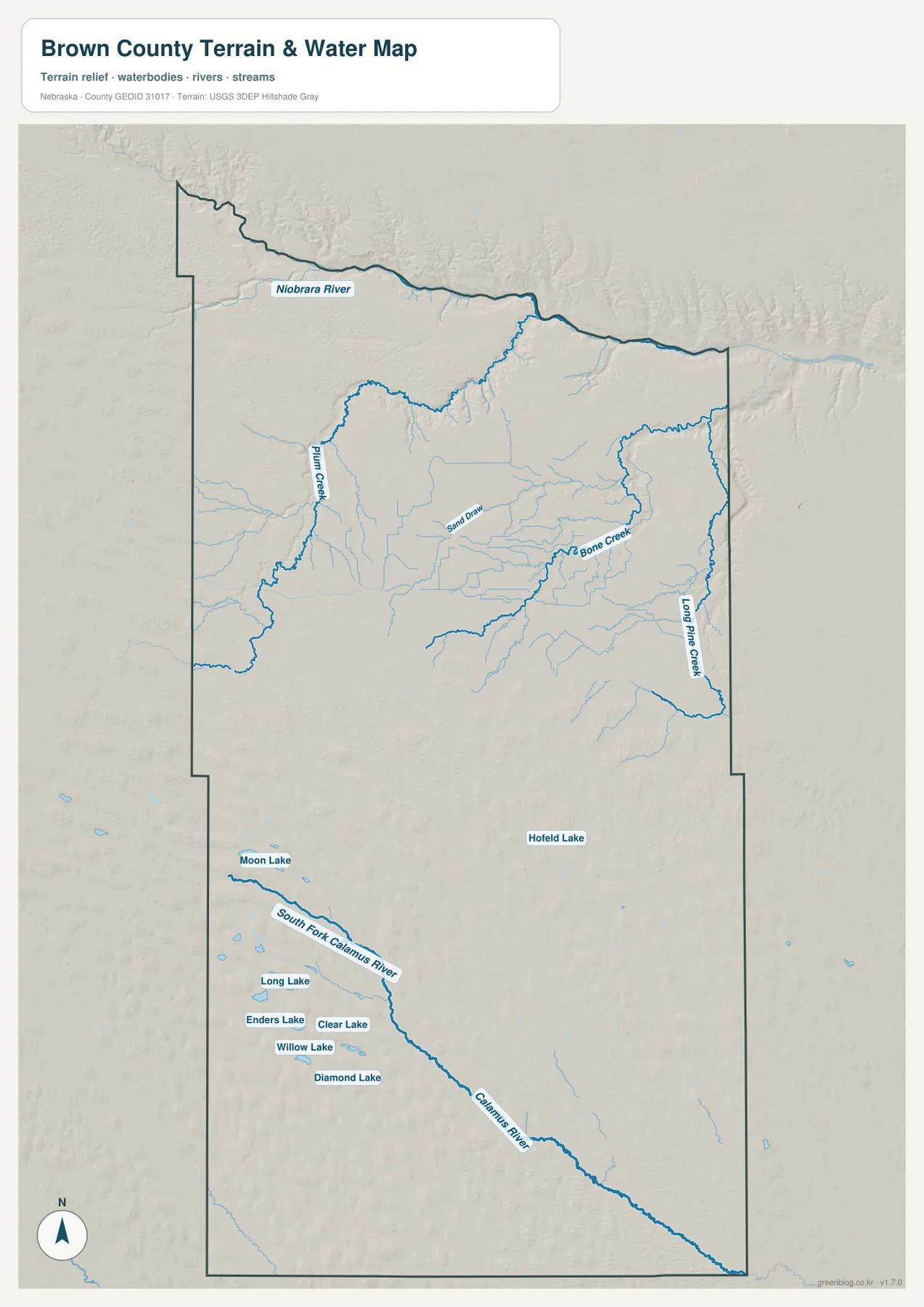
The Niobrara River is the dominant water reference in the north. It follows a long, winding section of the county boundary from west to east, with short tributaries descending into the valley from the Brown County side. Because the administrative boundary and the river course coincide for so much of the northern edge, the Niobrara is also a useful guide to the shape of the county.
Plum Creek is prominent in the western and central north, while Bone Creek cuts through the eastern-central section. Sand Draw and many smaller tributaries occupy the country between them. Long Pine Creek is especially clear near the eastern border, where it follows a deep valley northward toward the Niobrara system.
The southern half has a different water pattern. South Fork Calamus River begins near a cluster of small lakes and continues southeast as part of the Calamus River system. Moon Lake, Long Lake, Enders Lake, Clear Lake, Willow Lake, and Diamond Lake are concentrated in the southwest, while Hofeld Lake appears farther east. These scattered lakes fit the Sandhills landscape of ridges separated by lower wet pockets.
This water map is intended for geographic reference. It does not define flood zones, legal water rights, parcel boundaries, channel depths, or navigability, and it should not be used as a substitute for current agency data when those questions matter.
Elevation rises from the river valleys into the southern Sandhills
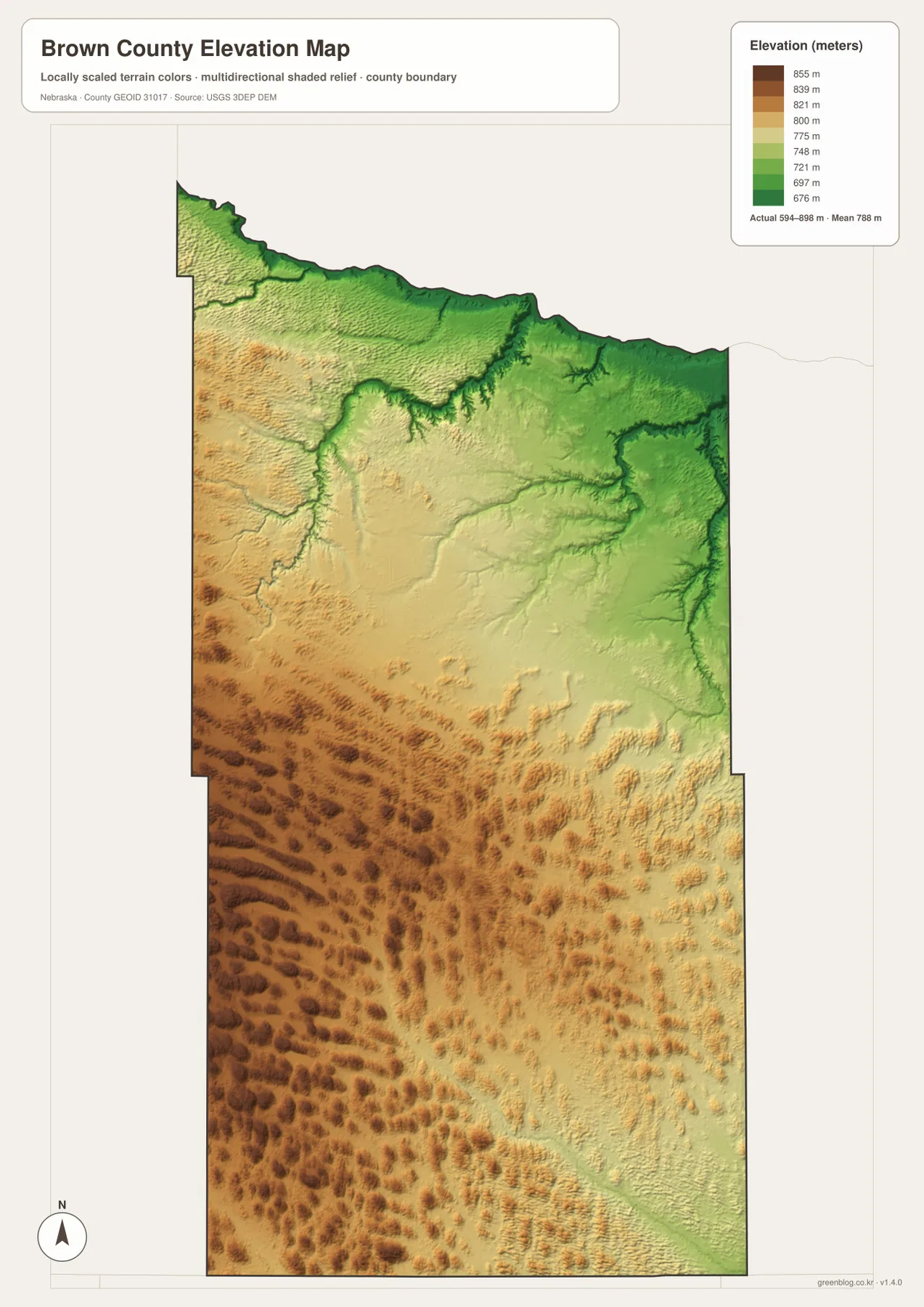
The elevation map reports an actual county-wide range of roughly 594 to 898 meters, with a mean near 788 meters. The lowest green terrain follows the Niobrara River along the northern edge and continues into major tributary valleys such as Long Pine Creek and Bone Creek.
Elevation generally increases toward the west and southwest. Yellow and brown colors cover much of the southern half, where long, narrow Sandhills ridges repeat across the landscape. Rather than forming a single mountain front, the higher ground consists of many parallel and overlapping hills separated by shallow depressions and stream corridors.
The northern half is not uniformly flat. Land rises quickly away from the Niobrara valley, and Plum Creek, Bone Creek, and Long Pine Creek cut distinct lower corridors into the surrounding uplands. The eastern side near Long Pine is especially dissected, with numerous short tributary valleys creating a much rougher surface than the broad county outline suggests.
The colors are scaled locally for Brown County and are intended for relative comparison within this map. They should not be matched directly with colors on another county map, and the generalized surface is not survey-grade data for engineering, construction, drainage design, or property work.
Long Pine Creek shows where water and relief meet most clearly
The Long Pine area is one of the best places to connect the water and elevation views. Nebraska Game and Parks notes that Long Pine State Recreation Area straddles Long Pine Creek and provides access for hiking and trout fishing. On the county map, the creek occupies a deep eastern valley that is easy to trace toward the Niobrara River.
Keller Park State Recreation Area, also in the Long Pine area, is associated with Bone Creek and several small lakes. Nebraska Game and Parks describes it as a canyon setting with tree-covered bluffs and opportunities for fishing and hiking. Together, Bone Creek and Long Pine Creek show why the eastern part of Brown County has such pronounced local relief compared with the more open uplands between major valleys.
Brown County organized in 1883 with Ainsworth as the permanent seat
History Nebraska records that Brown County was organized in 1883 and that Ainsworth became the permanent county seat at the first county election. Brown County originally covered a larger area, but later county divisions created Keya Paha and Rock Counties and left Brown County with approximately its present form.
The county’s comprehensive plan also describes how early bridges across the Niobrara River and local creeks improved movement of people and goods. Today U.S. 20 and modern highways dominate the transportation map, but the same basic geography remains important: deep river and creek valleys still shape where roads can cross the landscape.
Using the four map views together
For basic orientation, start with Ainsworth and U.S. 20, then move east to Long Pine and west to Johnstown. Add the Niobrara River along the north and the county’s long southern extension, and the overall shape becomes much easier to remember. The city-connection map simplifies the same northern corridor with two direct-distance labels.
For physical geography, trace the Niobrara River first and then follow Plum Creek, Bone Creek, and Long Pine Creek into the interior. Farther south, the South Fork Calamus River and scattered lakes show a different Sandhills water pattern. The elevation map adds the vertical dimension by showing low river valleys against higher western and southern ridges.
For printing or classroom display, the downloadable high-resolution JPG files preserve more detail than the web previews. The county map emphasizes roads and boundaries, the city map shows Ainsworth-centered straight-line relationships, the water map identifies major streams and lakes, and the elevation map highlights the contrast between the Niobrara valley and the Sandhills uplands.
Frequently Asked Questions
Are the 8- and 10-mile city distances driving distances?
No. The city map shows straight-line distances from Ainsworth: about 8 miles to Long Pine and 10 miles to Johnstown. Actual driving mileage depends on the road network and the exact starting and ending points.
Where is the lowest terrain in Brown County?
The lowest ground is concentrated along the Niobrara River at the northern edge and in major creek valleys such as Long Pine Creek and Bone Creek. The county-wide elevation range is about 594 to 898 meters, with higher terrain becoming more common toward the west and southwest.
Can the water map be used for flood or property decisions?
No. It is a geographic reference showing the Niobrara River, Long Pine Creek, the Calamus River system, and named lakes. Flood risk, water rights, parcel boundaries, access, and channel conditions require current authoritative records.
Map File Information
The ZIP contains the original high-resolution JPG files for the Brown County boundary and road map, city-connection map, terrain and water map, and elevation map.
- Included Files: Use only the versions confirmed in the article and supplied images
- File Type: Use the confirmed download contents
- Intended Use: Printing, education, presentations, and map-based projects
Related Maps
Sources and references
- Brown County Government official website
- Brown County Comprehensive Plan
- History Nebraska – Brown County Historical Note
- Nebraska Game and Parks – Long Pine State Recreation Area
- USGS National Hydrography
- USGS 3D Elevation Program
These maps are intended for geographic reference. For legal boundaries, land ownership, flood determinations, water rights, road conditions, construction, surveying, or other decisions requiring current authoritative information, consult Brown County and the responsible state or federal agency.
Green Map creates custom-edited map images using open geographic data sources such as geoBoundaries, Natural Earth, OpenStreetMap, and government open data. These maps are edited visual materials, not raw data files, and are provided for education, documents, presentations, and graphic reference.