Boyd County stretches across northern Nebraska between the Niobrara River along the south and the Missouri River near the northeastern edge. Butte and Spencer provide the clearest central reference points, while Naper, Anoka, Bristow, Lynch, and Monowi extend the settlement pattern west and east. The county is narrow but long, with roads and creek valleys crossing rolling terrain that generally becomes lower toward the east.
This page brings together the county road map, ranked city distribution, water features, and elevation map. The original high-resolution JPG versions are also available in a ZIP download for printing, classroom work, or personal reference when the smaller road and stream labels need to remain readable.
Table of Contents
A long northern Nebraska county between two major rivers
Boyd County occupies a distinctive strip of northeastern Nebraska close to South Dakota. The official county profile describes it as lying between the Niobrara and Missouri rivers and identifies Butte as the county seat. On the map, Butte sits west of the midpoint while Spencer lies farther east, giving readers two convenient anchors for the county’s long shape.
Holt and Rock Counties lie to the west and southwest, Keya Paha County is south, and Knox County is visible toward the east. The northeastern corner narrows toward the Missouri River, while the southern boundary bends with the Niobrara. The contrast between straight survey lines and river-shaped boundaries is one of the county map’s most recognizable features.
Highway 12 and U.S. 281 organize much of the eastern road network
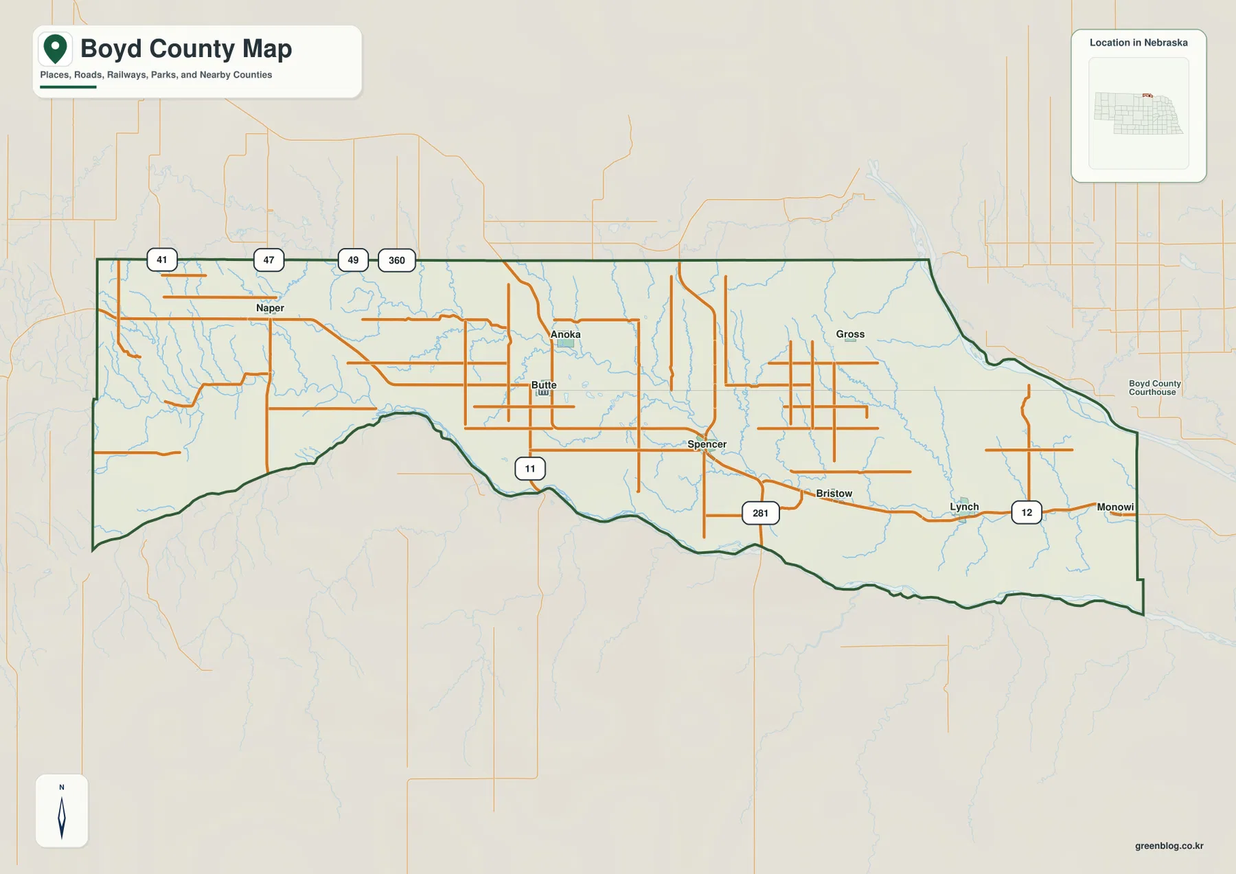
The clearest east-west road sequence runs from the Naper side toward Spencer, Bristow, Lynch, and Monowi. Nebraska Highway 12 is especially prominent in the east, passing through Lynch and continuing toward Monowi. Near Spencer, U.S. 281 provides an important north-south reference, while Highway 11 reaches south from the Butte area toward the Niobrara River side of the county.
Naper sits near roads marked 41, 47, 49, and 360 in the northwest. Anoka and Butte are relatively close in the central-western section, and the road network becomes more continuous toward Spencer and Lynch. Because the communities are widely spaced, using route numbers together with rivers and creeks is more helpful than relying on town names alone.
The official county page also notes that Highway 12 serves many communities and that U.S. 281 passes near Spencer. The map is not a live traffic source, so road work, closures, surfaces, and exact travel times should be checked separately before driving.
Six ranked communities are spread across the county
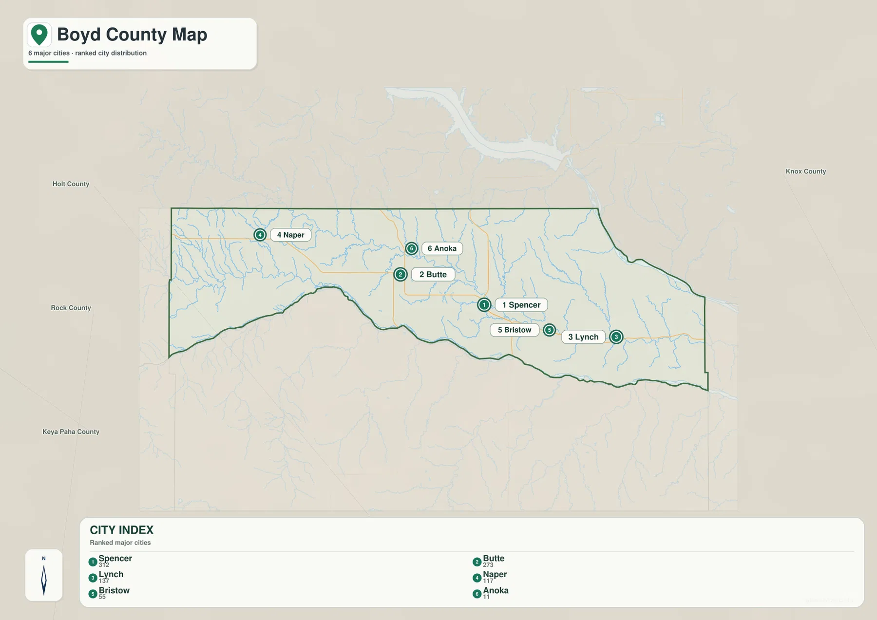
The city distribution map ranks Spencer first, Butte second, and Lynch third, followed by Naper, Bristow, and Anoka. Spencer and Butte are the main central references, while Naper marks the west and Lynch and Bristow help define the eastern half. Anoka lies north of Butte, adding another small community to the county’s widely dispersed pattern.
No city-to-city connector lines or mileage values appear on the supplied map. It would therefore be misleading to add a straight-line distance that is not part of the graphic. The map’s purpose is positional: it shows where the selected communities sit relative to one another across a long rural county.
Monowi appears on the general county map but is not included in the six-place ranking. That difference illustrates the roles of the two maps. The general view provides broader geographic context, while the city map simplifies the county to a selected set of ranked communities.
Keya Paha, Ponca, Niobrara, and Missouri waters frame the landscape
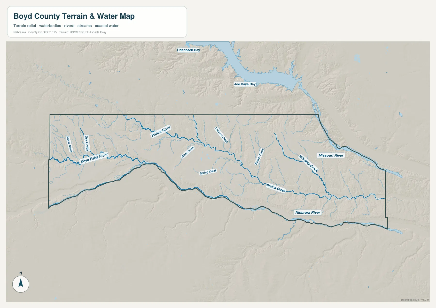
The Keya Paha River is the strongest water reference in the west. It enters the county from the western side and continues toward the southern boundary, where the Niobrara River forms a long natural edge. Smaller streams such as Dry Creek and Monowi Creek cut through the uplands around the western river system.
Across the central and northern interior, the Ponca River runs eastward through a broad network of tributaries. Taubers Creek, Dizzy Creek, and Beaver Creek descend toward the same general system. Farther south, Ponca Creek follows a long low corridor toward the eastern part of the county, with Whiskey Creek joining the drainage network nearby.
The Missouri River appears along the northeastern edge, with Joe Days Bay and Odenbach Bay visible beyond the county boundary. Together, the Missouri in the northeast and the Niobrara in the south create two large river references around a county interior divided by smaller creeks. This arrangement is also noted in Boyd County’s official geographic description.
The water map is intended for geographic reference. It does not establish flood zones, legal water rights, parcel boundaries, channel depth, access, or current streamflow. Those questions require current information from the relevant agencies.
Elevation falls from western uplands into the river valleys
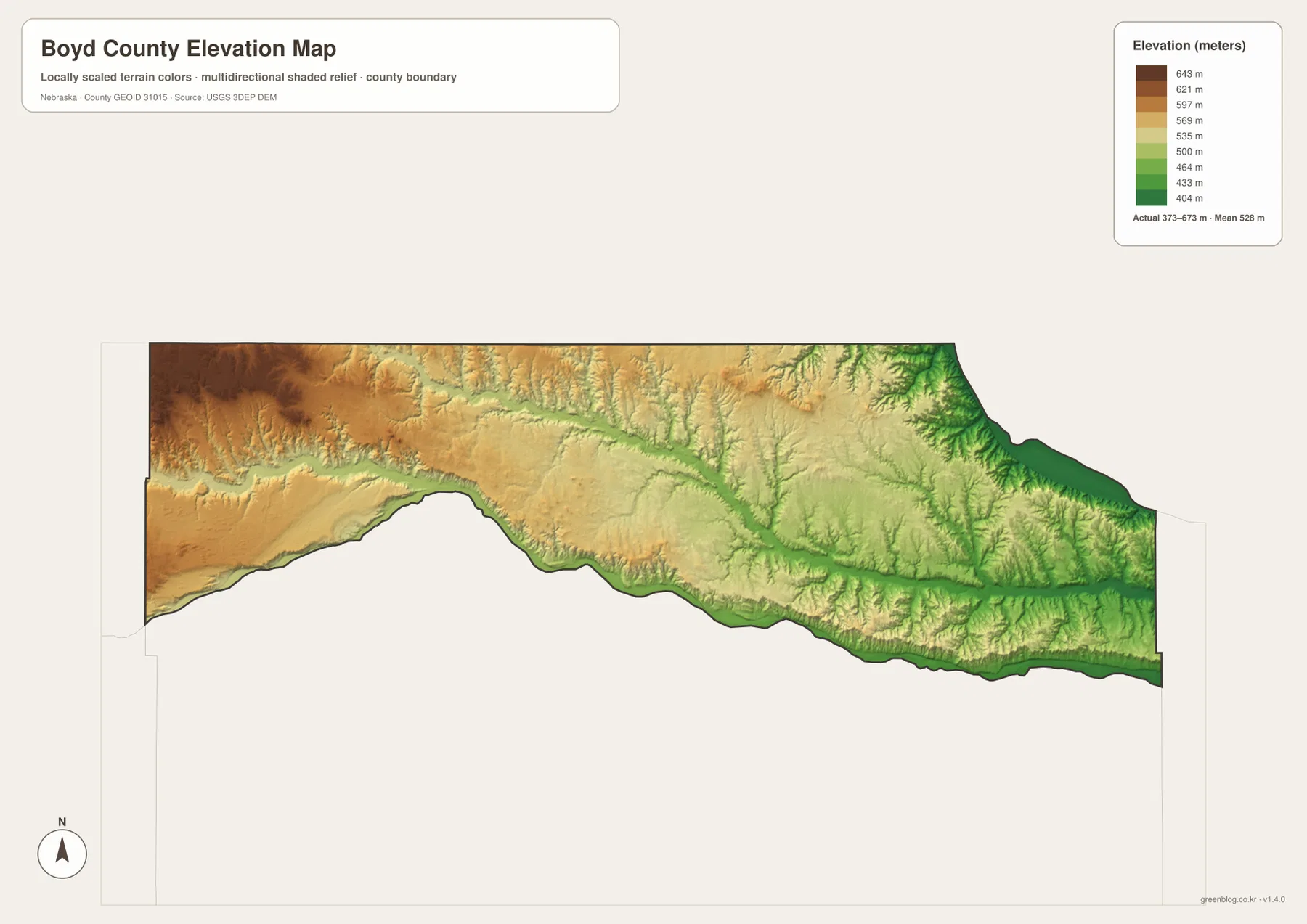
The elevation map reports an actual range of about 373 to 673 meters, with a mean near 528 meters. The highest brown terrain occupies the west and northwest, while greens become more common toward the east. A difference of roughly 300 meters across the county creates a clear contrast between western uplands and lower river corridors.
The Niobrara River follows a low green band along much of the southern boundary. The Missouri River side in the northeast is also deeply cut, and lower corridors trace the Ponca River and Ponca Creek through the interior. Comparing the water and elevation maps makes the relationship between stream valleys and lower terrain especially easy to see.
Western Boyd County has more elevated rolling country, but it is interrupted by the Keya Paha River and many tributary valleys. The eastern half is lower overall without being flat; small ravines and ridges become particularly noticeable toward the Missouri River. The result is a long county with a steady regional drop but considerable local relief.
The color scale is local to Boyd County and is meant for relative comparison within this map. It is not survey-grade elevation for engineering, construction, drainage design, or property work. Those tasks require original USGS data and professional measurements where appropriate.
Butte became the permanent county seat after organization in 1891
Boyd County’s official history states that the county was organized on August 1, 1891, by proclamation of Governor John M. Thayer. Butte City was chosen as the temporary county seat because of its central location and population, and voters later made it the permanent seat. Its position on the modern map still makes it a practical western-central reference.
The county was named for James E. Boyd, who was governor when the legislation creating Boyd County was approved in March 1891. History Nebraska explains that much of present-day Boyd County had previously been part of Dakota Territory and reservation land, which helps explain why the history of Nebraska’s northern boundary is unusually complicated in this area.
Use the towns and rivers together to read the map quickly
For a first look, locate Butte and Spencer, then follow the road sequence west toward Naper and east toward Lynch and Monowi. Add the Niobrara River along the south and the Missouri River at the northeastern edge, and the county’s long, narrow shape becomes much easier to understand. U.S. 281 and Highway 12 provide especially useful reference lines in the eastern half.
For physical geography, trace the Keya Paha River, Ponca River, and Ponca Creek before switching to the elevation map. The higher west, lower east, and deeply cut river valleys line up clearly across the two views, making it easier to see why roads and settlements occupy particular corridors.
The city map is best for comparing the positions of Spencer, Butte, Lynch, Naper, Bristow, and Anoka. The general map adds roads and extra place names such as Monowi. When larger labels are needed, the high-resolution JPG files in the ZIP are better suited to printing or classroom display.
Frequently Asked Questions
Is Butte or Spencer the county seat?
Butte is the county seat. Spencer is ranked first on the supplied city map, but the official Boyd County history identifies Butte as the permanent county seat selected by voters after the county was organized.
Do both the Niobrara and Missouri rivers touch Boyd County?
Yes. The Niobrara River follows much of the southern boundary, while the Missouri River appears at the northeastern edge. The interior also contains the Keya Paha River, Ponca River, Ponca Creek, and numerous smaller tributaries.
Can the 373-673 meter elevation range be used for surveying?
No. The range summarizes a generalized county-wide elevation surface intended for geographic comparison. Surveying, construction, engineering, and detailed drainage work require original elevation data and professional field measurements where appropriate.
Map File Information
The ZIP contains the original high-resolution JPG files for the Boyd County boundary and road map, ranked city map, terrain and water map, and elevation map.
- Included Files: Use only the versions confirmed in the article and supplied images
- File Type: Use the confirmed download contents
- Intended Use: Printing, education, presentations, and map-based projects
Related Maps
Sources and references
- Boyd County official profile and history
- History Nebraska – Adjusting Nebraska’s Northern Boundary
- U.S. Census Bureau TIGER/Line Shapefiles
- USGS National Hydrography
- USGS 3D Elevation Program
These maps are intended for geographic reference. For legal boundaries, land ownership, flood determinations, water rights, road conditions, construction, surveying, or other decisions requiring current authoritative information, consult Boyd County and the responsible state or federal agency.
Green Map creates custom-edited map images using open geographic data sources such as geoBoundaries, Natural Earth, OpenStreetMap, and government open data. These maps are edited visual materials, not raw data files, and are provided for education, documents, presentations, and graphic reference.