Antelope County in northeastern Nebraska is organized around Neligh and the Elkhorn River valley, but its communities are spread widely across the county. Orchard and Brunswick lie in the north, Clearwater is west of Neligh, Oakdale sits southeast along the river corridor, and Elgin occupies the southern part of the county. The road, water, and elevation maps show how those places relate to a landscape of broad uplands cut by many stream valleys. High-resolution map files are available for download in the section below.
This page explains the county boundary and road network, the ranked city distribution, the Elkhorn River and its tributaries, and the main elevation differences. The original high-resolution JPG versions of the supplied maps are also available together in a ZIP below for printing, classroom use, or personal reference.
Table of Contents
Neligh is the clearest starting point for Antelope County
Antelope County lies in northeastern Nebraska, with Neligh serving as the county seat. The official county profile identifies Neligh as the administrative center and lists Brunswick, Clearwater, Elgin, Neligh, Oakdale, Orchard, Royal, and Tilden among the county’s towns and cities. On the supplied map, Neligh sits a little east of the county’s center and is surrounded by one of the strongest concentrations of roads.
Knox County borders the north, while Pierce and Madison Counties are visible along the eastern side. Boone County lies to the southwest, and Wheeler and Holt Counties are on the west. Antelope County is generally taller north-to-south than east-to-west, with an indentation in the western boundary that gives the outline a less regular shape than a simple rectangle.
Roads spread outward from Neligh toward six distinct communities
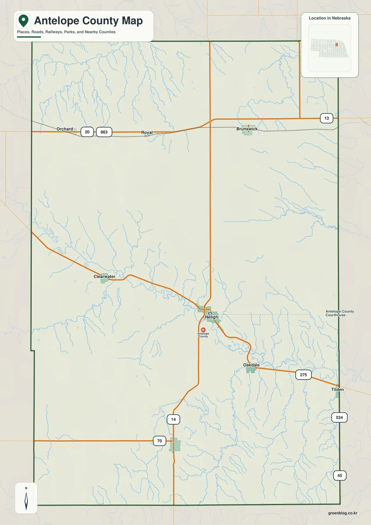
Neligh is the easiest place to orient the general map. A main east-west route approaches from the Clearwater side, passes through Neligh, and continues toward Oakdale and Tilden. Highway 14 runs south from the Neligh area, giving the central part of the county a strong north-south connection as well. These routes make the county seat a practical anchor before moving out into the more widely spaced rural roads.
In the north, Orchard and Brunswick are separated by a long east-west stretch of open country. Roads marked 20 and 863 appear near Orchard, while Brunswick connects toward Highway 13 on the east. Royal is labeled between the two. Southeast of Neligh, Highway 275 follows the Oakdale-Tilden corridor, making that section of the map one of the clearest examples of a road following the same general direction as the Elkhorn River valley.
The southern map includes routes marked 70 and 14, with roads 45 and 534 near the southeastern edge. Road spacing becomes wider in parts of the northwest and southwest, reflecting the more rural character of those areas. The map is useful for orientation, but construction, closures, surface conditions, and exact driving times should be checked with current transportation or routing information.
Six ranked places reveal a dispersed settlement pattern
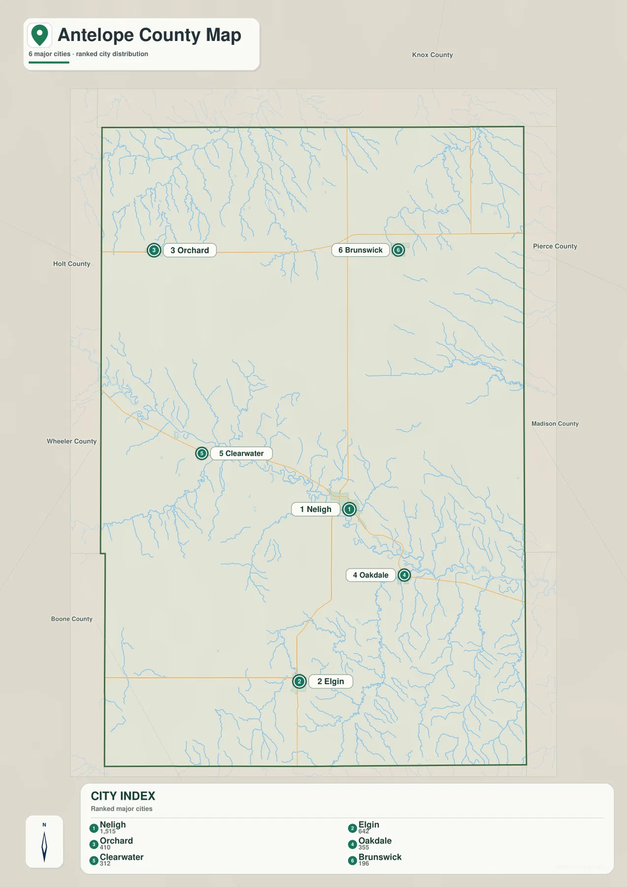
The ranked city map shows Neligh first, followed by Elgin, Orchard, Oakdale, Clearwater, and Brunswick. Rather than forming one compact cluster, the six selected places occupy different parts of the county. Neligh is east-central, Elgin is in the south, Orchard is northwest, Oakdale is southeast, Clearwater is west of Neligh, and Brunswick lies in the northeast.
This city map does not draw connectors or provide straight-line mileage between the ranked places. That distinction is important because no distance values should be inferred from the graphic. Its main value is positional: it shows the county’s leading communities in relation to one another and makes the dispersed settlement pattern easy to compare with the road and water maps.
The official county profile includes Royal and Tilden in its 2020 community list even though the ranked city map selects only six places. The two sources therefore serve different purposes. The official list provides a broader community inventory, while the supplied city map emphasizes the relative rank and location of a smaller set of major places.
The Elkhorn River forms the county’s central water corridor
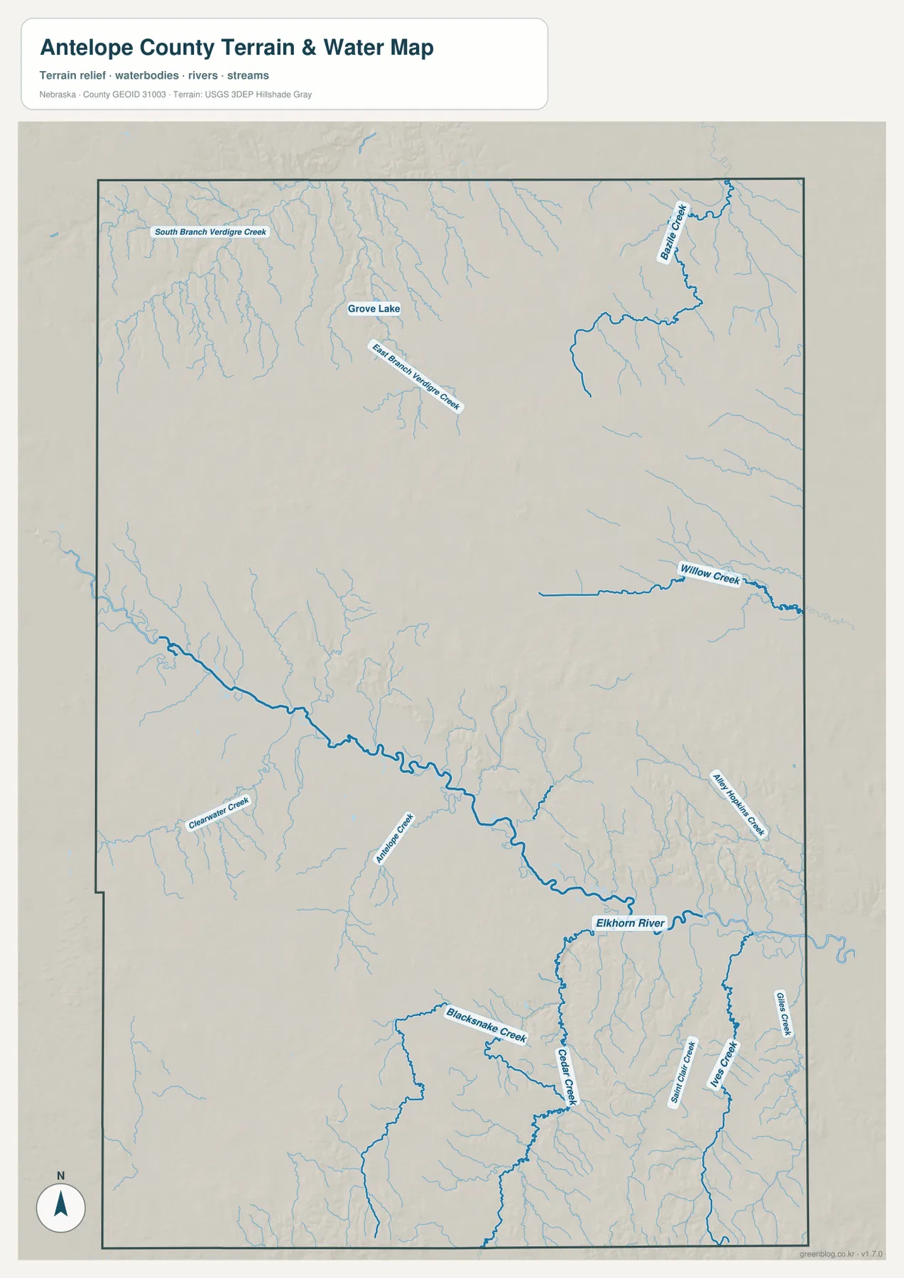
The Elkhorn River is the strongest water reference on the map. It enters from the west, bends through the central part of Antelope County between Clearwater and Neligh, and continues southeast toward Oakdale before leaving the county. The river occupies a broad low corridor, and many smaller streams descend from higher ground toward this central valley.
Beaver Creek stands out in the northeast, while Willow Creek crosses the eastern-central section. In the northwest, South Branch Verdigre Creek and East Branch Verdigre Creek occupy a separate set of valleys, with Grove Lake nearby. These northern waterways show that not every drainage in the county belongs to the same immediate river corridor, even though the Elkhorn remains the most visually dominant central feature.
South of the Elkhorn, Clearwater Creek and Antelope Creek approach the central valley, and the lower half of the county contains a dense network of smaller waterways. Blacksnake Creek, Cedar Creek, Sandy Creek, Lose Creek, Case Creek, and Andy Hollow Creek are all labeled. Their branching pattern becomes especially useful when compared with the elevation map, where the same valleys appear as lower green corridors between higher ridges.
This water map is intended for geographic reference. It does not establish current flow conditions, legal water rights, flood insurance zones, parcel boundaries, or navigability. Those questions require up-to-date records from the responsible local, state, or federal agency.
Elevation falls into the Elkhorn valley and rises in the west and southwest
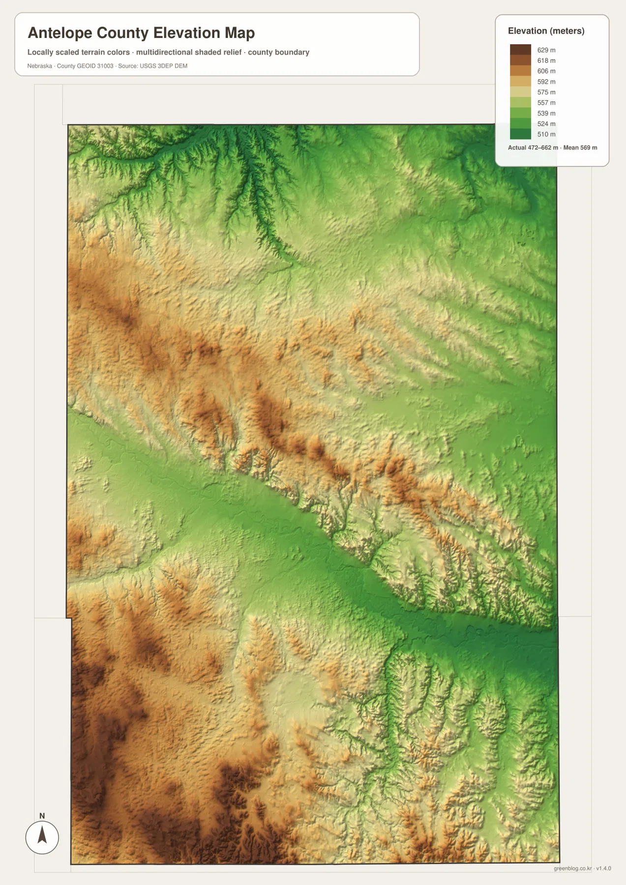
The elevation map reports an actual range of approximately 472 to 662 meters, with a mean near 569 meters. The lowest green terrain follows the Elkhorn River corridor across the center and east, and broad lower areas also appear in the northeast. Neligh and Oakdale sit close to this lower band rather than on the higher western uplands.
Higher ground is most visible in the west-central and southwestern sections. Tan and brown ridges spread across those areas, interrupted by narrow stream valleys. The northwest also alternates between elevated uplands and lower drainage lines, but the strongest concentration of higher terrain appears toward the southwest corner.
The southern half is particularly varied. Although the Elkhorn valley itself is low, ridges rise quickly south of the river around the Cedar Creek and Blacksnake Creek systems, and another broad higher zone occupies the county’s lower edge. The result is not a flat, uniform plain but a rolling landscape in which stream valleys cut visibly into the surrounding uplands.
The colors are scaled locally for Antelope County, so they are best used to compare places within this map. The same shade on a different county map may correspond to another elevation. The surface is also generalized and is not survey-grade data for engineering, construction, drainage design, or property work.
Neligh, Clearwater, and Oakdale share the lower river setting
Comparing the road, water, and elevation layers shows why Neligh, Clearwater, and Oakdale form a recognizable central corridor. All three are positioned close to the Elkhorn River, and important roads follow the same general lowland. Neligh gains additional importance because east-west and north-south routes intersect near the county seat.
The other ranked communities occupy different terrain. Orchard and Brunswick are north of the main Elkhorn valley, while Elgin lies farther south near more elevated and strongly dissected ground. The city map alone shows the separation, but the water and elevation views explain why those communities belong to distinct local settings rather than one continuous built-up corridor.
A county-seat rivalry between Oakdale and Neligh shaped local history
History Nebraska records that Antelope County was organized on June 15, 1871. Oakdale became the early county seat, and a courthouse was built there in 1874 before burning the following year. After repeated elections and local competition, Neligh became the county seat in 1884. Seeing both towns on the same Elkhorn River corridor gives that nineteenth-century rivalry a clear geographic setting.
The historical record also notes that permanent settlement began in 1868 and that the Fremont, Elkhorn and Missouri Valley Railroad was the first railroad to enter the county. Transportation and river geography therefore influenced local growth long before the modern road system shown on today’s map. The present relationship between Neligh and Oakdale still reflects a corridor that has been important for movement and settlement for more than a century.
Choosing the most useful map for your question
For basic orientation, begin with Neligh and the Elkhorn River on the general map. From there, follow the central road corridor west toward Clearwater and southeast toward Oakdale, then use Highway 14 to locate Elgin to the south. Orchard and Brunswick provide useful northern reference points for understanding the full length of the county.
For physical geography, start with the Elkhorn River and then trace Beaver Creek, Willow Creek, the Verdigre Creek branches, Antelope Creek, and Cedar Creek into their surrounding valleys. The elevation map adds the missing vertical context by showing lower green drainage corridors and the higher western and southwestern ridges around them.
For community distribution, the ranked city map provides the cleanest comparison of Neligh, Elgin, Orchard, Oakdale, Clearwater, and Brunswick. The downloadable JPG files are larger than the web previews and are better suited to printing or classroom display when labels and terrain details need to remain readable.
Frequently Asked Questions
Why are there no distance lines between the six ranked places?
The supplied city map ranks and locates Neligh, Elgin, Orchard, Oakdale, Clearwater, and Brunswick, but it does not include city-to-city connectors or mileage. Use the general road map for relative location and a current routing service when actual driving distance or travel time is needed.
Which river is the main geographic reference in Antelope County?
The Elkhorn River is the strongest central reference. It passes between Clearwater, Neligh, and Oakdale, while tributaries such as Beaver Creek, Willow Creek, Antelope Creek, and Cedar Creek drain other parts of the county. The elevation map shows the Elkhorn corridor as one of the lowest continuous areas.
Can the 472-662 meter elevation range be used for surveying?
No. The range summarizes a generalized county-wide elevation surface intended for geographic comparison. Engineering, construction, drainage design, and surveying require original elevation data and, where appropriate, professional field measurements.
Map File Information
The ZIP contains the original high-resolution JPG files for the Antelope County boundary and road map, ranked city map, terrain and water map, and elevation map.
- Included Files: Use only the versions confirmed in the article and supplied images
- File Type: Use the confirmed download contents
- Intended Use: Printing, education, presentations, and map-based projects
Related Maps
Sources and references
- Antelope County official profile
- History Nebraska – Antelope County Historical Note
- U.S. Census Bureau TIGER/Line Shapefiles
- USGS National Hydrography
- USGS 3D Elevation Program
These maps are intended for geographic reference. For legal boundaries, land ownership, flood determinations, water rights, road conditions, construction, surveying, or other decisions requiring current authoritative information, consult Antelope County and the responsible state or federal agency.
Green Map creates custom-edited map images using open geographic data sources such as geoBoundaries, Natural Earth, OpenStreetMap, and government open data. These maps are edited visual materials, not raw data files, and are provided for education, documents, presentations, and graphic reference.