Flathead County is best understood as a low central valley surrounded by increasingly rugged mountain country. Kalispell, Whitefish, and Columbia Falls sit in the most connected part of the county, while West Glacier, Lake McDonald, Hungry Horse Reservoir, and the South Fork Flathead River lie in steeper terrain to the east and southeast. The maps on this page show that transition clearly: roads and towns are concentrated in the valley, while long river corridors and high ridges dominate the outer mountain areas. High-resolution JPG versions of the maps are available together in the download ZIP below.
Kalispell provides the strongest starting point for the road network, but the Flathead River system provides the stronger physical reference. Whitefish River, Stillwater River, and the Flathead River occupy the lower interior, and the elevation map keeps the same zone in deep green. Beyond Columbia Falls, the county changes quickly as U.S. 2 and the river corridors enter narrower mountain valleys toward West Glacier.
Table of Contents
The main road network spreads across the Kalispell lowland
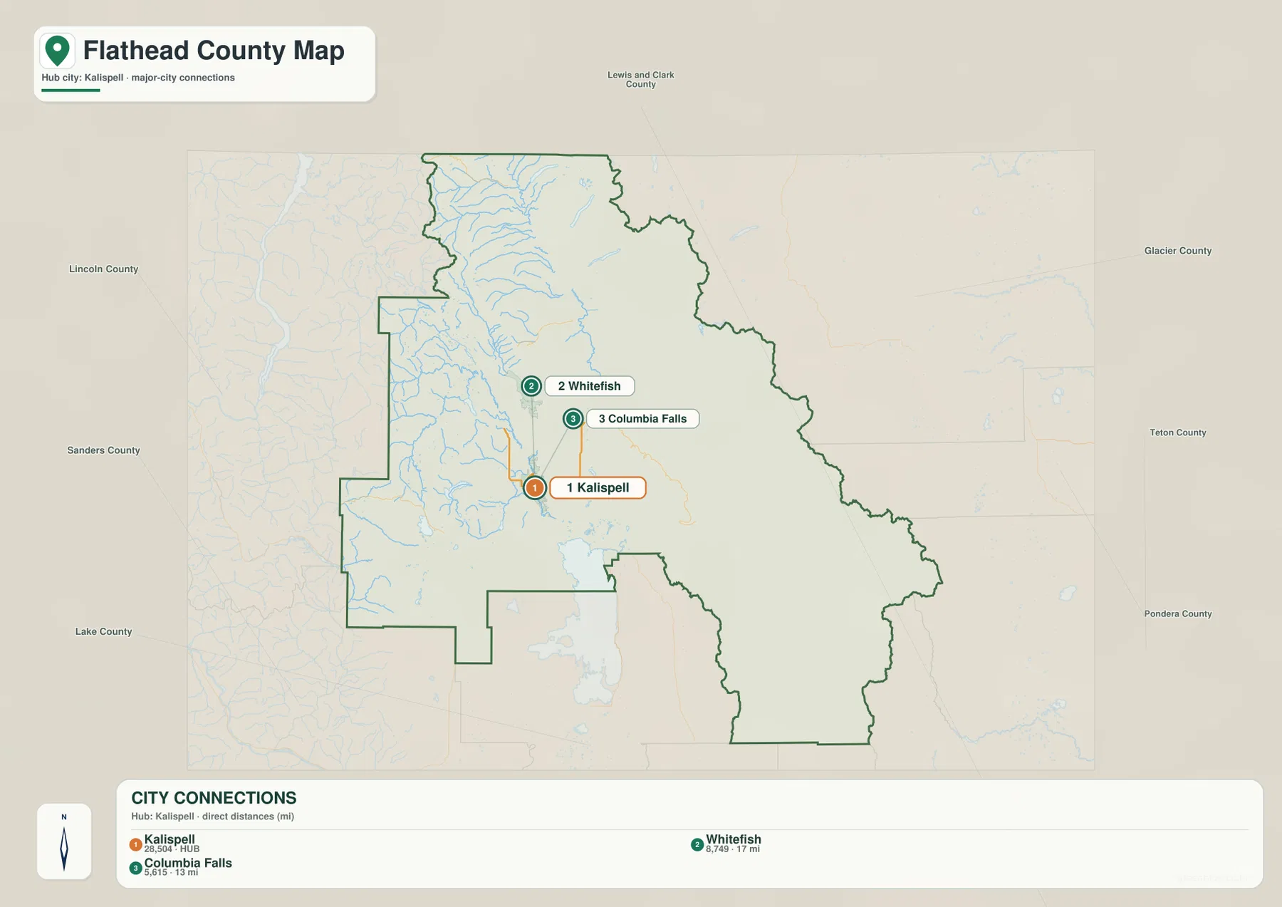
On the general county map, Kalispell lies in the broad lowland west of the Flathead River. U.S. 93 runs north toward Whitefish and south toward Lakeside, while U.S. 2 travels northeast through Columbia Falls toward West Glacier. Route 40 crosses between the Whitefish and Columbia Falls sides, reinforcing the close relationship among the county’s three main urban centers.
The western half of the county looks different. Kila and Marion sit along a more lightly settled road corridor, Little Bitterroot Lake provides a clear landmark, and Niarada appears in the southwestern projection. East of the central valley, Coram and West Glacier sit where the road network begins to follow more restrictive mountain terrain.
The map is useful for understanding the overall road pattern, but it is not a live travel service. Mountain weather, construction, seasonal restrictions, and Glacier National Park road conditions should be checked separately before a trip.
Whitefish and Columbia Falls sit within one compact valley network
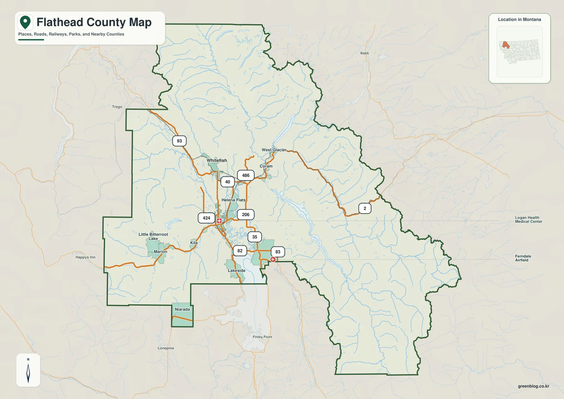
The city-connections map uses Kalispell as the hub and links it directly with Whitefish and Columbia Falls. Whitefish is labeled 17 miles from Kalispell, while Columbia Falls is 13 miles away. These measurements are straight-line distances, not road mileage, so actual driving distances depend on the route taken.
The printed city index shows Kalispell at 28,504, Whitefish at 8,749, and Columbia Falls at 5,615. Those are the values embedded in the supplied map rather than guaranteed current estimates. Current population figures should be checked with recent Census data.
Direction matters as much as distance. Whitefish lies north of Kalispell and is closely associated with Whitefish Lake, while Columbia Falls sits northeast, closer to the Flathead River and the gateway road toward West Glacier. The city map therefore works best as a quick scale reference before returning to the more detailed road map.
The Flathead River system defines the county’s low center
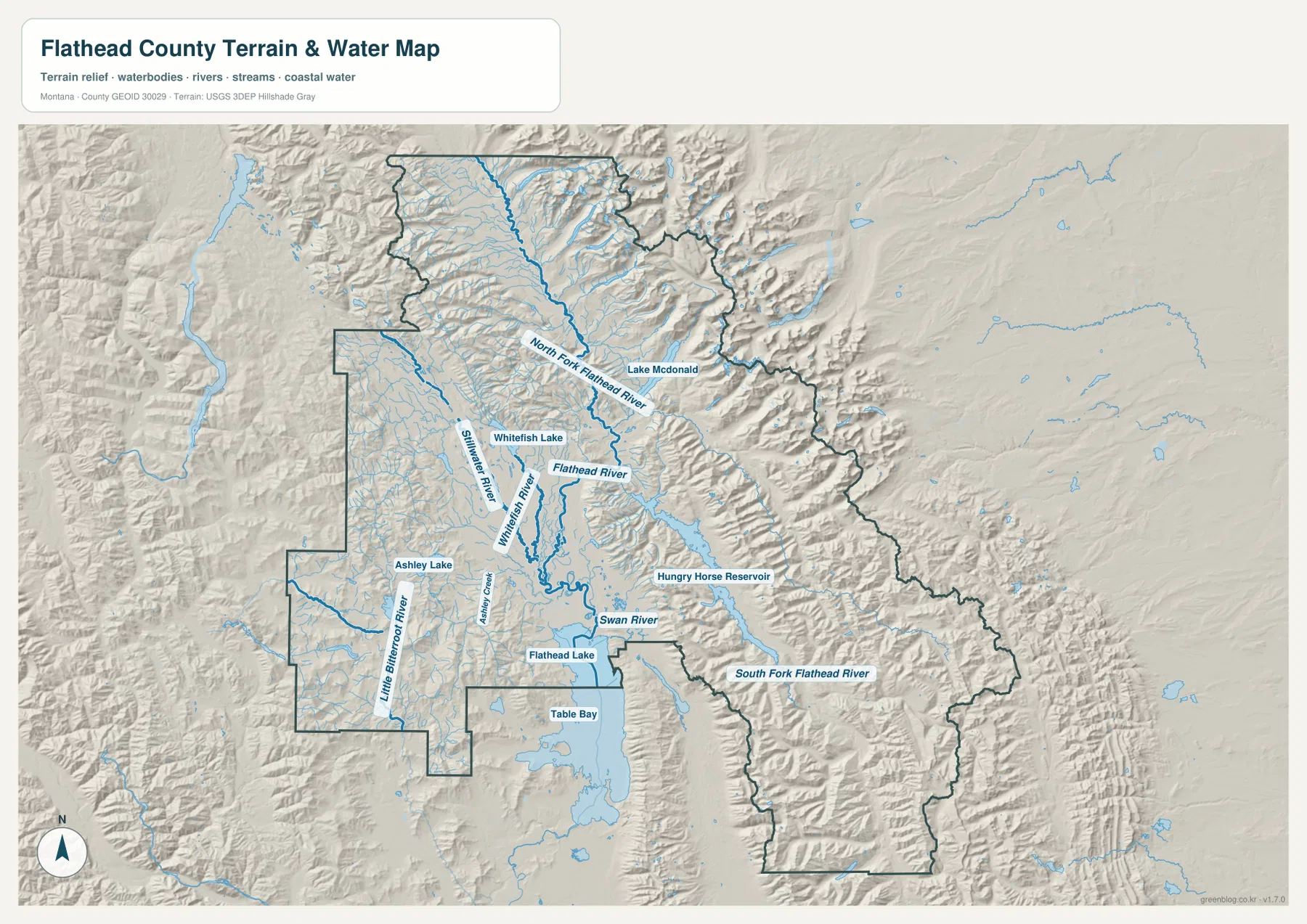
The terrain-and-water map makes the Flathead River system the most important physical feature in the middle of the county. North Fork Flathead River descends from the north, while Whitefish River and Stillwater River run through the lower valley farther west. The main Flathead River passes the Columbia Falls side before continuing south through the broader lowland.
Whitefish Lake lies just north of the central urban area, Ashley Lake sits to the west, and the northern part of Flathead Lake appears along the county’s southern edge. Little Bitterroot River provides another western drainage reference. These large water features are easier to use for orientation than the many small mountain streams that appear across the map.
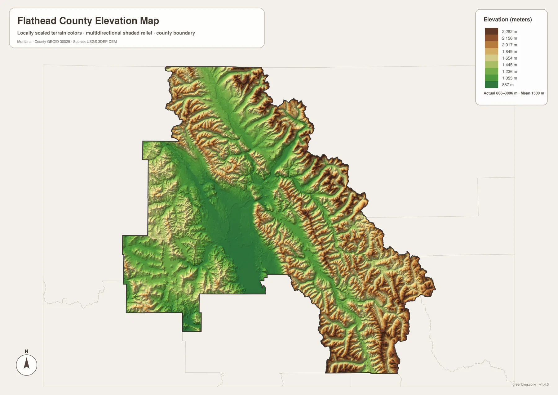
The same low river corridors stand out on the elevation map. The waterways remain green while surrounding ridges rise quickly around them. This map is intended for geographic reference and should not be used for flood zoning, navigation, parcel boundaries, water-rights decisions, or safe-crossing determinations.
Lake McDonald and Hungry Horse sit inside a much steeper eastern landscape
Lake McDonald occupies a long mountain valley in the northeastern part of the county. The National Park Service identifies the Lake McDonald valley as a major west-side area of Glacier National Park, and the county map shows U.S. 2 approaching the park through Columbia Falls, Coram, and West Glacier. That route marks the transition from the broad central valley to a narrower mountain corridor.
Hungry Horse Reservoir lies farther south and is surrounded by high relief. Swan River appears to its west, while South Fork Flathead River runs through the rugged southeastern interior. These features are not isolated landmarks; together they define an eastern half of the county where water and terrain are far more useful for orientation than town names.
The mountain setting also makes access more seasonal. Park roads, forest routes, and reservoir access can change with weather and management conditions, so the static map should be paired with current agency information before travel.
The county rises from about 866 meters to 3,006 meters
The elevation map reports an actual range of about 866 to 3,006 meters, with a mean elevation near 1,500 meters. Kalispell, Whitefish, Columbia Falls, and much of the central valley remain in dark green. Moving north, east, or southeast, the colors change rapidly through yellow and brown as high ridges close in around the river corridors.
North Fork Flathead River cuts a long lower route through the northern mountains. Around Lake McDonald, the terrain rises sharply on both sides of the lake valley. South Fork Flathead River shows a similar pattern in the southeast, where a narrow lower corridor is bordered by high mountain blocks.
The west and southwest contain their own hills and lower mountain terrain, but the most continuous high relief is concentrated on the eastern side. This makes the county’s overall shape easy to summarize visually: a low central valley surrounded by progressively higher terrain. The elevation surface is intended for county-wide comparison and should not be treated as survey-grade or engineering-grade data for a specific property.
Reading the county from valley floor to mountain edge keeps the map coherent
A useful way to read Flathead County is to move outward from the low central valley rather than jumping between unrelated place names. Kalispell, Whitefish, and Columbia Falls form the main connected urban area. From there, U.S. 2 and the Flathead River lead east toward West Glacier, while other water corridors continue toward Hungry Horse and the South Fork.
The west and southwest form a quieter transition zone around Kila, Marion, Ashley Lake, and Little Bitterroot Lake. The south opens toward the northern end of Flathead Lake. These areas are less mountainous than the Glacier side but more broken than the central urban valley, giving the county a gradual transition before the much steeper eastern terrain.
The WebP images are convenient for quick browsing. The high-resolution JPG files in the ZIP are better for printing or enlarging small road, river, and lake labels. Since these are static reference maps, current road closures, park access, and water conditions should always be checked through official sources before travel or field use.
Frequently Asked Questions
Are the Kalispell-to-Whitefish and Columbia Falls distances driving distances?
No. Whitefish is shown at 17 miles and Columbia Falls at 13 miles from Kalispell as straight-line distances. Actual driving distances are longer because roads follow established routes rather than the direct connector lines.
Which part of Flathead County has the highest terrain?
The highest terrain is concentrated in the northern, eastern, and southeastern mountain areas. The central valley around Kalispell, Whitefish, and Columbia Falls is much lower, while the Lake McDonald and South Fork Flathead River sides rise sharply.
Can the 866–3,006 meter elevation range be used for a property or engineering project?
No. The range is a county-wide reference for comparing the low central valley with surrounding mountain terrain. Precise site elevations should come from an authoritative source such as the USGS 3D Elevation Program and, when necessary, a professional survey.
Map File Information
Download the Flathead County county, city, terrain-and-water, and elevation maps as high-resolution A3 JPG files.
- Included Files: county map, city map, terrain and water map, elevation map
- File Type: ZIP containing 4 JPG files
Related Maps
Sources and References
County government and local information are available from the official Flathead County website. Glacier National Park access and Lake McDonald information can be checked through the National Park Service Glacier maps page and the Lake McDonald Valley page.
Boundary and road-reference data are available from U.S. Census Bureau TIGER/Line Shapefiles. Hydrographic data can be checked through USGS National Hydrography, and elevation data through the USGS 3D Elevation Program.
Green Map creates custom-edited map images using open geographic data sources such as geoBoundaries, Natural Earth, OpenStreetMap, and government open data. These maps are edited visual materials, not raw data files, and are provided for education, documents, presentations, and graphic reference.