Fergus County is easiest to understand from the Lewistown basin outward rather than as one continuous stretch of central Montana. Lewistown sits near the middle of the county’s settled road network, while Winifred lies north, Denton northwest, Moore southwest, and Grass Range east. Waterways then divide the broad spaces between those towns: Judith River and Warm Spring Creek cross the central-west, Dog Creek organizes the north, and Box Elder Creek helps define the east. The landscape rises dramatically toward Crystal Lake and the southwestern mountains. High-resolution JPG versions of the maps on this page are available together in the download ZIP below.
The official Fergus County website places county government in Lewistown, and the map supports that role. Roads branch from the Lewistown area into every major part of the county, but farther from town the land is often easier to identify by creek valleys and elevation. The contrast between the lower northern and eastern country and the much higher southwest is one of the strongest features of the map set.
Table of Contents
Lewistown sits inside the county’s broad central basin
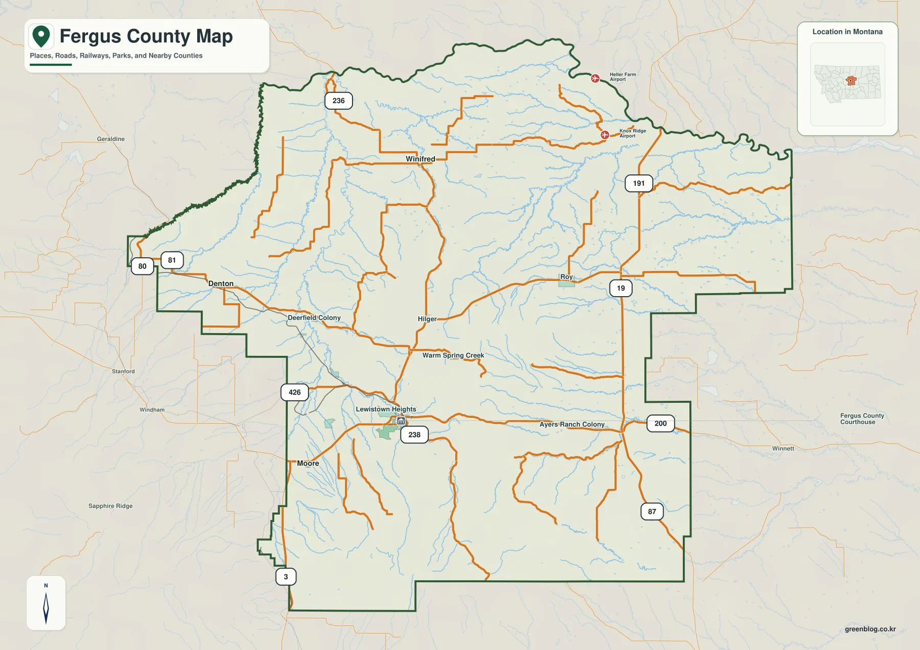
On the general county map, Lewistown lies near the northern edge of the southern half of Fergus County. Lewistown Heights appears just north of town, Route 238 crosses the area, and roads extend toward Moore in the southwest, Hilger and Winifred in the north, and Roy and Route 191 in the east. This road pattern gives the city a clear hub position without making the surrounding county look densely settled.
Denton and Deerfield Colony occupy the northwest, with routes 80 and 81 labeled nearby. Route 236 appears north of Winifred, while Route 3 and 426 provide western and southwestern references. East of Lewistown, Route 191 and 19 lead across large rural areas where towns are sparse and creek names become increasingly useful.
The map works well for regional orientation but not for live navigation. Winter closures, road work, unpaved surfaces, and travel times can change, especially away from the main routes.
Four straight-line links show how far the smaller towns spread from Lewistown
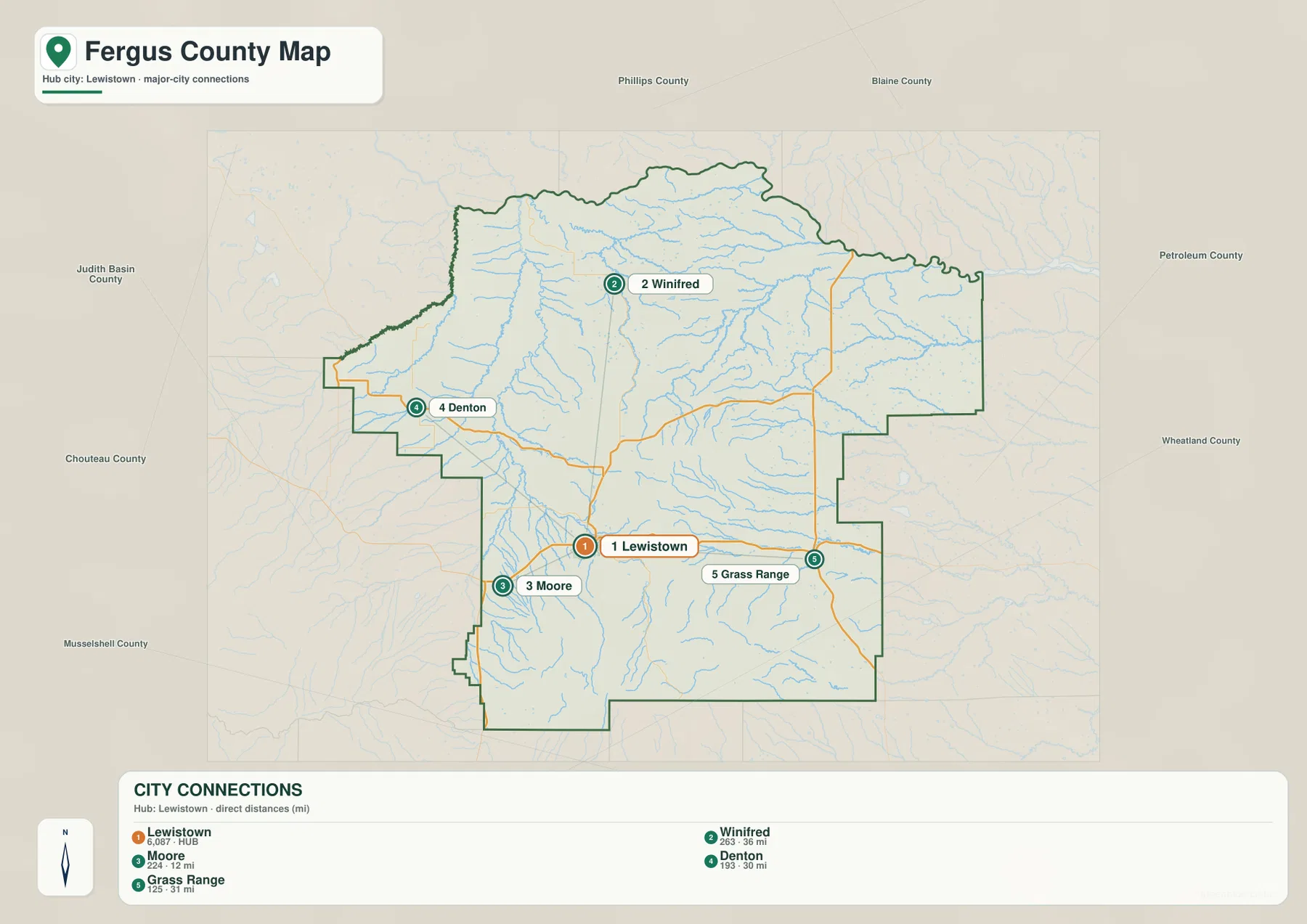
The city-connections map uses Lewistown as its hub and links it with Winifred, Moore, Denton, and Grass Range. The printed straight-line distances are 36 miles to Winifred, 12 miles to Moore, 30 miles to Denton, and 31 miles to Grass Range. These are not road mileages, so an actual trip can be longer where routes bend around hills or follow valley roads.
The map’s city index shows Lewistown at 6,087, Winifred at 263, Moore at 224, Denton at 193, and Grass Range at 125. Those figures are the values embedded in the supplied map and should not be treated as guaranteed current estimates. Current population figures should be checked through recent Census data.
The directions are just as useful as the numbers. Winifred is north of Lewistown, Denton northwest, Moore southwest, and Grass Range east. Once those positions are familiar, the general road map makes more sense because Hilger, Roy, and smaller roads fall naturally between the larger reference points.
Judith River marks the lower country west of Lewistown
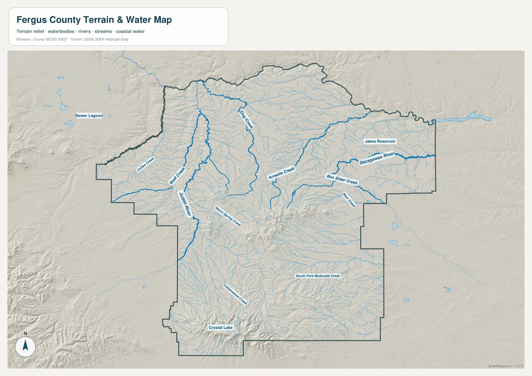
The terrain-and-water map shows Judith River as one of the strongest central-western waterways. Wolf Creek descends nearby, and Warm Spring Creek passes through the Lewistown side of the county. Coffee Creek lies farther west, while Cottonwood Creek extends through the southern interior. Together these channels show that the central county is a network of broad low valleys rather than one uniform plain.
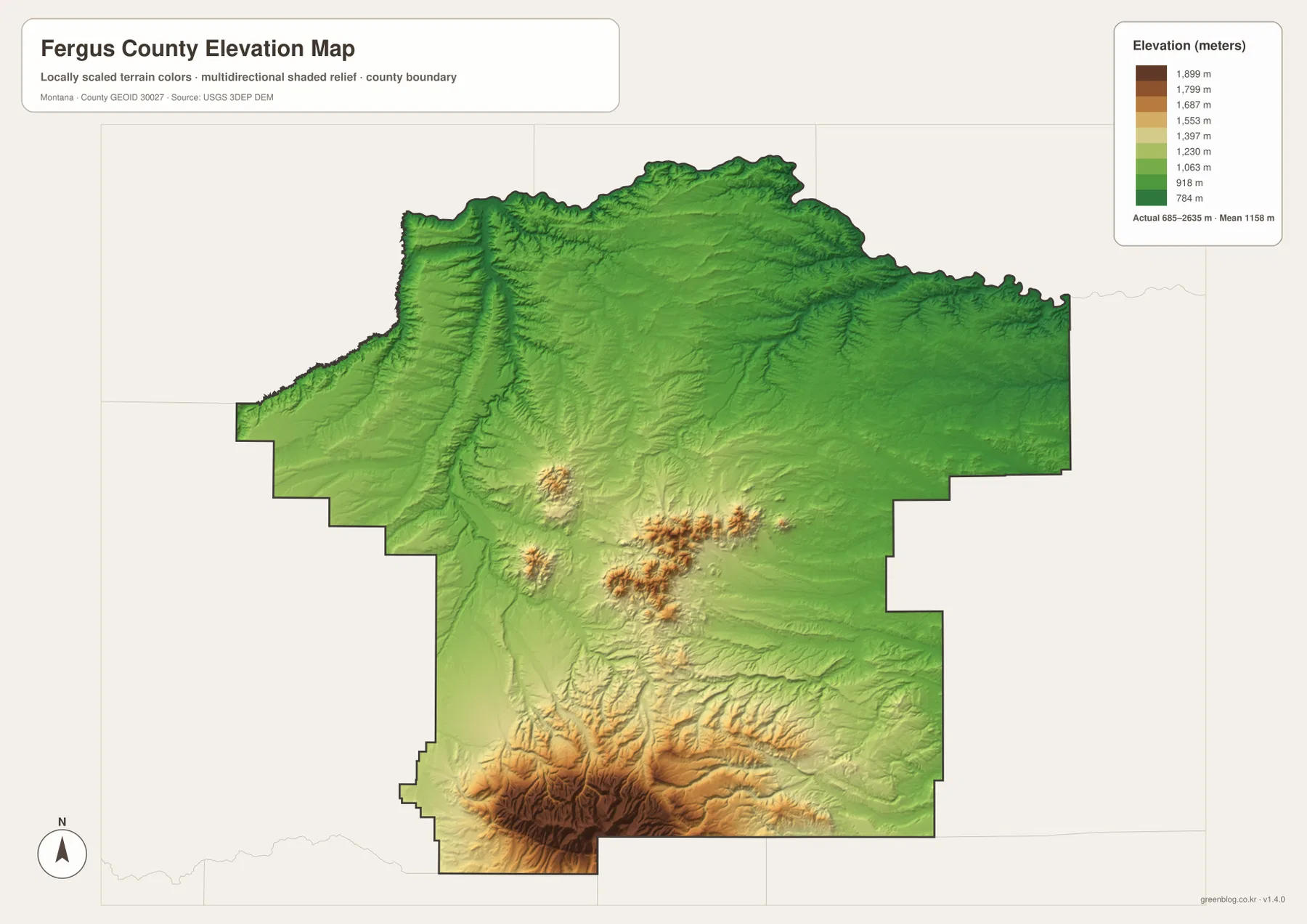
The elevation map reinforces that pattern. Judith River and Warm Spring Creek occupy lower ground than the ridges and mountain blocks around them. Following those low corridors makes it easier to see why roads and settlements tend to remain in more moderate terrain before the land rises toward the southwest.
The terrain-and-water map is a geographic reference rather than a flood, navigation, property, or water-rights product. Current stream conditions and parcel-specific information should be checked separately when needed.
Dog Creek and Box Elder Creek organize the lower north and east
Dog Creek provides a strong reference in the northern half near the Winifred side of the county. Numerous smaller tributaries join it across relatively open terrain. Armells Creek runs farther east through the middle of the county, where broad valleys are more common than steep mountain relief.
On the eastern side, Box Elder Creek and Bear Creek are among the most recognizable drainage names. The supplied map also labels Sacagawea River in the northeast, with Jakes Reservoir nearby. In this part of Fergus County, waterways often provide clearer location cues than towns because settlement is sparse.
South Fork McDonald Creek extends through the southern interior. Farther southwest, Crystal Lake appears in much steeper terrain, marking a sharp transition from the lower northern and eastern country into mountain relief.
Crystal Lake sits near the county’s highest terrain
The elevation map reports an actual range of about 685 to 2,635 meters, with a mean elevation near 1,158 meters. Large parts of the north and east appear in green, while the southwest rises quickly through yellow and brown. The highest terrain is concentrated around and beyond the Crystal Lake area.
Ridges and valleys are packed closely together in the southwestern mountains, and streams descend from that high country toward lower central and eastern areas. Smaller blocks of high terrain also appear through the south-central county, creating additional relief between Lewistown and the southern boundary.
Judith River, Dog Creek, Box Elder Creek, and other major drainages remain visible as lower corridors within the elevation surface. The map is useful for county-wide comparison, but it is not survey-grade or engineering-grade data for an individual property.
Three regional views make the county easier to navigate mentally
Instead of treating Fergus County as a list of towns and map types, it helps to divide it into three broad regions. The Lewistown basin and Judith River country form the central reference area. Winifred and Dog Creek define much of the north, while Grass Range and Box Elder Creek anchor the east. The southwestern mountain block around Crystal Lake stands apart as the highest and most rugged part of the county.
The city map adds scale to those regions. Moore is only 12 straight-line miles from Lewistown, while Winifred, Denton, and Grass Range are roughly 30 miles or more away. That distance, combined with the terrain differences, explains why the county can feel much larger than a quick glance at its boundary suggests.
The WebP images are convenient for quick browsing. The high-resolution JPG files in the ZIP are better for printing or enlarging smaller road and creek labels. Since the maps are static references, current road access, stream levels, and mountain conditions should be checked through official or local sources before field use.
Frequently Asked Questions
Which connected town is closest to Lewistown on the city map?
Moore is the closest of the four connected towns at 12 straight-line miles. Denton is 30 miles, Grass Range 31 miles, and Winifred 36 miles. These are straight-line measurements rather than driving distances.
Where is the highest terrain in Fergus County?
The strongest concentration of high terrain is in the southwest around Crystal Lake and the surrounding mountain area. The northern and eastern portions of the county are generally much lower.
Can the 685–2,635 meter elevation range be used for a property or engineering project?
No. The range is a county-wide reference for comparing lower valleys with higher mountain terrain. Precise site elevations should come from an authoritative source such as the USGS 3D Elevation Program and, when necessary, a professional survey.
Map File Information
Download the Fergus County county, city, terrain-and-water, and elevation maps as high-resolution A3 JPG files.
- Included Files: county map, city map, terrain and water map, elevation map
- File Type: ZIP containing 4 JPG files
Related Maps
Sources and References
County government and local background information are available from the official Fergus County website. Boundary and road-reference data can be checked through U.S. Census Bureau TIGER/Line Shapefiles.
Hydrographic reference data are available from USGS National Hydrography, and elevation data can be checked through the USGS 3D Elevation Program.
Green Map creates custom-edited map images using open geographic data sources such as geoBoundaries, Natural Earth, OpenStreetMap, and government open data. These maps are edited visual materials, not raw data files, and are provided for education, documents, presentations, and graphic reference.