Custer County covers a large area of southeastern Montana, with Miles City serving as the most useful reference point in the northwest and Ismay sitting far to the east. Major roads converge around Miles City, while long waterways divide the interior into broad valleys and rolling uplands. The Tongue River approaches Miles City from the south, the Powder River runs through the central-eastern part of the county, and Mizpah Creek forms another long drainage farther east. The maps shown on this page are also available as high-resolution JPG files in the download ZIP below.
The official Custer County site identifies Miles City as the county seat and notes its setting at the convergence of the Yellowstone and Tongue rivers. That description fits the map well: Miles City is where the county’s strongest road and river references come together. Eastward, settlement becomes sparse and Ismay is the only other ranked city on the supplied city map. Southward, the landscape is better understood through rivers, creeks, and elevation than through town names alone.
Table of Contents
Miles City anchors the road network in the northwest
On the general county map, Miles City sits close to the western edge of the northern half. I-94 and U.S. 12 pass through the area, and route numbers 158, 160, 489, and 119 appear nearby. The Custer County Courthouse and an airport symbol are also marked around Miles City, reinforcing its role as the county’s main administrative and transportation center.
North and northwest of the city, Hillcrest is labeled as a historical place, while Terry and Fallon appear beyond the county boundary. These outside references help place Custer County within the wider regional road network. The main eastbound route crosses a long stretch of the county before reaching Ismay, which occupies a small projecting section near the eastern side. The distance between the two ranked communities is visually striking even without a mileage label.
Route 59 runs toward the southern part of the county, and Route 439 is labeled along the eastern side. Several local roads extend through the interior where rivers and creeks divide the terrain into long north-south corridors. The map is useful for orientation, but it is not a live navigation product; construction, unpaved-road conditions, seasonal access, and actual travel times should be checked with current sources.

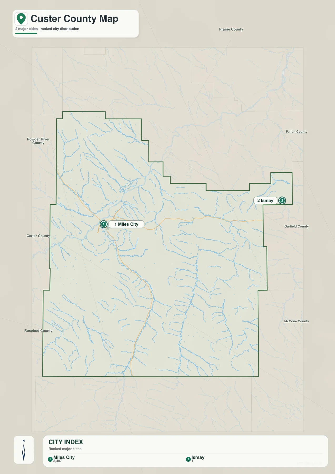
The city map reduces the county to Miles City and Ismay
The city map ranks two places: Miles City and Ismay. Its printed index lists Miles City at 8,407 and Ismay at 1. Those figures are values embedded in the supplied map and should not be treated as guaranteed current population estimates. For up-to-date demographic data, consult recent U.S. Census Bureau releases.
The more important information on this view is location. Miles City lies in the northwest, while Ismay sits far to the east near a narrow part of the county boundary. Neighboring county labels help with orientation: Powder River County is west, Prairie County is north, Fallon and Garfield counties are to the east, and Rosebud County lies to the south and southwest. The city map therefore gives a quick sense of how broad Custer County is even though it contains few ranked communities.
No connector line or distance number is printed between Miles City and Ismay. The spacing should be read only as a positional reference, not as road mileage or travel time. Anyone planning the actual trip should use the general county map together with current navigation and road-condition information.
Tongue River is the clearest southern water route into Miles City
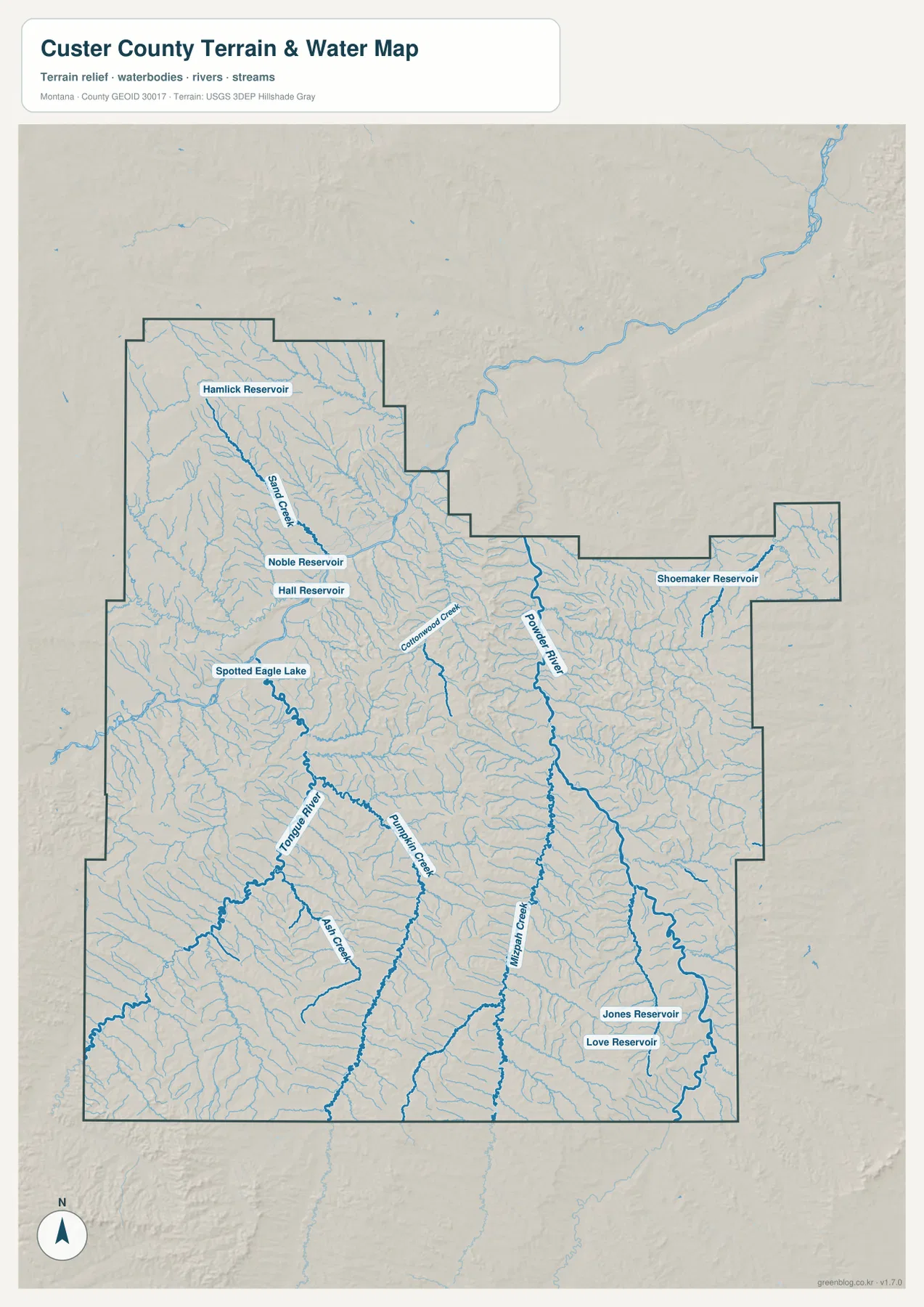
On the terrain-and-water map, the Tongue River is the strongest named channel in the western half of the county. It flows north from the southern boundary toward the Miles City area. Montana’s visitor information also describes the Tongue as a tributary that reaches the Yellowstone River at Miles City, giving the river a useful connection to the county’s main city.
Ash Creek and Pumpkin Creek are labeled around the Tongue River drainage, while Spotted Eagle Lake appears farther northwest near the Miles City side. In the northwestern interior, Sand Creek runs through a separate network of tributaries, and several small reservoirs—Hamlick Reservoir, Noble Reservoir, and Hall Reservoir—provide local reference points. These names are especially useful in a county where many small drainages otherwise look similar.
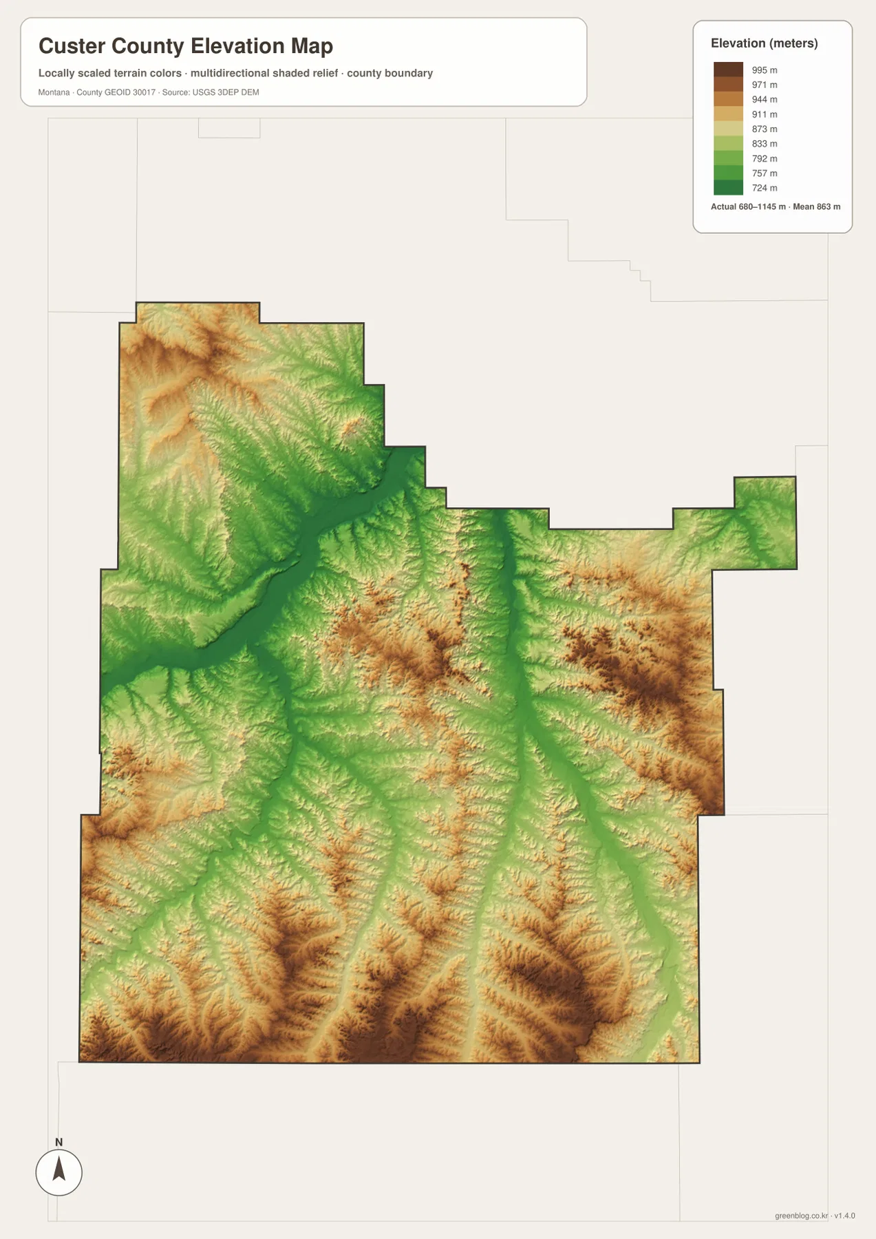
The river valley also stands out on the elevation map. Lower green terrain follows the Tongue River northward, while surrounding uplands rise in yellow and brown. The terrain-and-water map is intended for geographic reference; it does not establish flood zones, water depth, property boundaries, water rights, or safe crossing locations.
Powder River and Mizpah Creek divide the central and eastern interior
East of the Tongue River, the Powder River forms another major north-south corridor. It runs through the central-eastern part of Custer County and receives many smaller tributaries from both sides. Cottonwood Creek is one of the named streams approaching this drainage from the northwest. The Powder River valley is broad enough to remain visible even on the county-wide view.
Farther east, Mizpah Creek creates a separate long drainage. Jones Reservoir and Love Reservoir are labeled near the southeastern part of the county, while Shoemaker Reservoir appears closer to the northeastern side and the Ismay area. Together, these features show that eastern Custer County is broken by many creek valleys rather than forming one continuous flat plain.
Several waterways continue beyond the county boundary, which is important when reading a map limited to one county. The supplied image is designed to show the portion within and around Custer County, not the entire watershed. For basin-wide flow information or current stream conditions, an official hydrology source such as the USGS should be used.
Elevation ranges from about 680 to 1,145 meters
The elevation map reports an actual county range of about 680 to 1,145 meters, with a mean elevation near 863 meters. Low areas are shown in green, while higher uplands shift through yellow and brown. The total vertical range is moderate compared with western Montana mountain counties, but the contrast between river valleys and surrounding broken hills is clear throughout Custer County.
Low green corridors follow the Tongue River, Powder River, and Mizpah Creek. The Powder River in particular forms a long north-south depression through the central-eastern portion of the county. Around these valleys, branching tributaries create narrow cuts into higher ground. The Tongue River side shows a similar pattern, especially where several streams converge northward toward Miles City.
The broadest high areas appear along parts of the southern and eastern county, with additional elevated terrain in the northwest. Brown ridges become tightly spaced near the southern boundary, while the eastern half contains repeated uplands separated by green drainage corridors. This map is suitable for county-wide comparison, not for surveying, engineering, construction, or determining the precise elevation of an individual property.
Miles City, then the rivers, provide the simplest way to organize the county
A practical approach is to begin at Miles City and then move east and south. The road map shows I-94 and U.S. 12 around Miles City and the long route toward Ismay. The terrain-and-water map then replaces sparse town names with stronger natural references: Tongue River in the west, Powder River farther east, and Mizpah Creek near the eastern interior.
Once those three drainages are familiar, smaller features become easier to locate. Sand Creek and the northwestern reservoirs help organize the upper-left part of the county, while Spotted Eagle Lake is useful near Miles City. Jones and Love reservoirs mark the southeast, and Shoemaker Reservoir provides a reference closer to Ismay. The elevation map ties the same areas together by showing each main drainage as a lower strip between higher hills.
The WebP images embedded in the article are convenient for quick viewing. The high-resolution JPG files in the ZIP are better for printing or enlarging small road, creek, and reservoir labels. Because these maps are static references, changing conditions such as road closures, stream levels, and land-access restrictions should be checked through current official or local sources.
Frequently Asked Questions
Does the city map show the distance between Miles City and Ismay?
No. The city map ranks and locates Miles City and Ismay but does not print a connector distance or road mileage between them. For an actual trip, use the general road map together with current navigation and road-condition information.
Are the Tongue River and Powder River in the same part of Custer County?
They are both within the county but occupy different valleys. The Tongue River runs through the western and southwestern side toward Miles City, while the Powder River lies farther east and runs north through the central-eastern interior. The terrain-and-water map makes the separation easy to see.
Can the 680–1,145 meter elevation range be used for a property or engineering project?
No. The range is a county-wide reference for comparing lower river valleys with higher uplands. Precise site elevations for property, construction, or engineering work should come from an authoritative source such as the USGS 3D Elevation Program and, when necessary, a professional survey.
Map File Information
Download the Custer County county, city, terrain-and-water, and elevation maps as high-resolution A3 JPG files.
- Included Files: county map, city map, terrain and water map, elevation map
- File Type: ZIP containing 4 JPG files
Related Maps
Sources and References
Custer County identifies Miles City as the county seat and notes its location at the convergence of the Yellowstone and Tongue rivers on the official County Facts page. Regional information about Miles City and the Tongue River is also available from Visit Montana.
Boundary and road-reference data can be checked through U.S. Census Bureau TIGER/Line Shapefiles. Hydrographic reference data are available from USGS National Hydrography, and elevation data can be checked through the USGS 3D Elevation Program.
Green Map creates custom-edited map images using open geographic data sources such as geoBoundaries, Natural Earth, OpenStreetMap, and government open data. These maps are edited visual materials, not raw data files, and are provided for education, documents, presentations, and graphic reference.