Broadwater County is easiest to understand by following the low country through its middle. Townsend sits near the center, Canyon Ferry Reservoir fills a long reach to the north, and the Missouri River continues south toward Toston. Higher ground rises on both sides of that corridor, so the county changes quickly from broad valley floor to mountain slopes even though the principal roads and settlements remain concentrated near the middle. The maps in this article can be viewed on the page, and the matching high-resolution JPG files are available together in the download ZIP below.
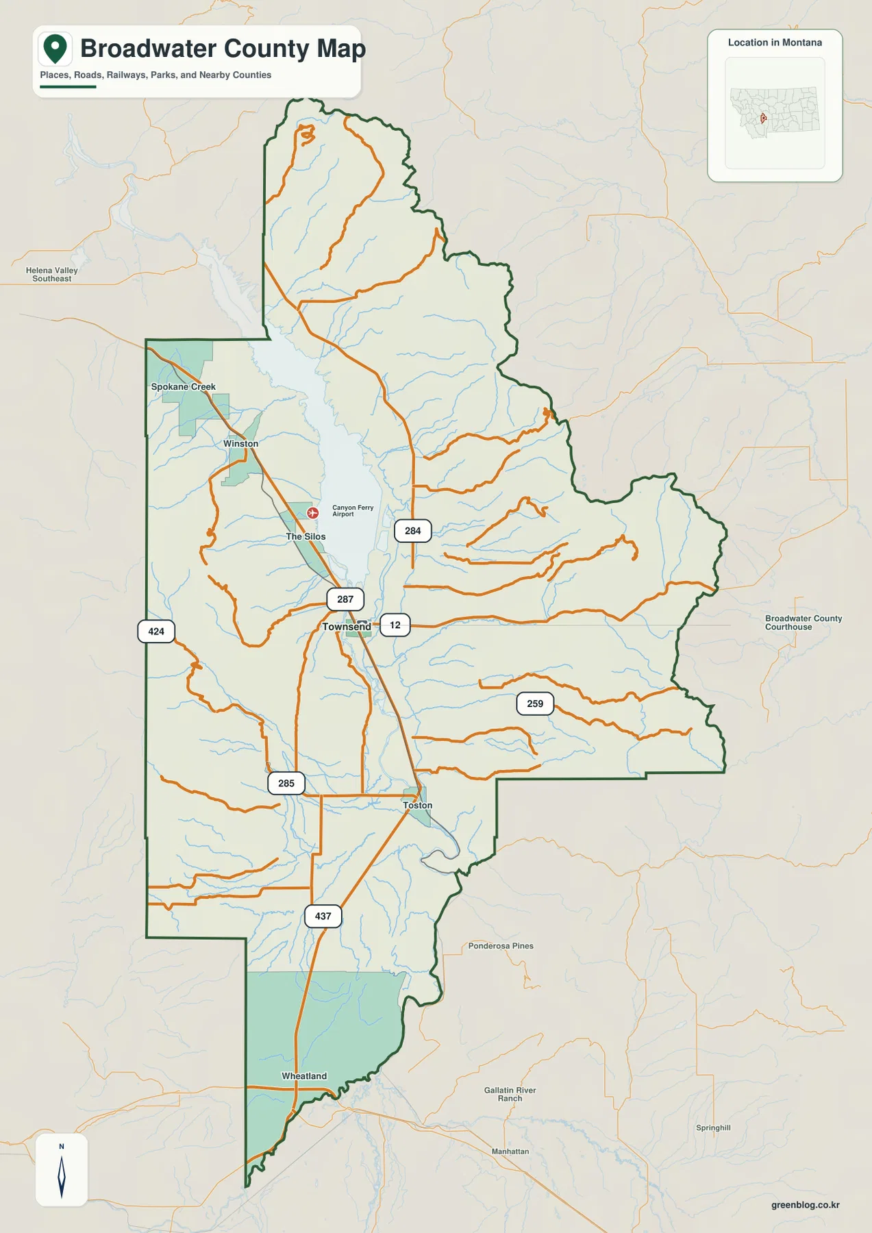
U.S. 287 supplies the clearest north-south reference, while U.S. 12 crosses the valley at Townsend. Winston and The Silos lie north of town near the reservoir, and Toston marks the southern river corridor. Looking at roads, water, and elevation together shows why Broadwater County does not feel like a uniformly open basin: the valley is broad around Townsend, but the county boundary reaches well into rugged country to the east and west.
Table of Contents
Townsend sits at the county’s most useful road crossroads
Townsend is the natural starting point on the county map because U.S. 287 and U.S. 12 meet in its vicinity. Following U.S. 287 north leads toward The Silos, Canyon Ferry Airport, and Winston; continuing south leads toward Toston and the long southern extension of the county. This arrangement makes Townsend more than a central label on the map—it is also the point from which the county’s main north-south travel pattern is easiest to read.
Several numbered routes branch away from the central corridor. Route 284 reaches toward the northeastern side of Canyon Ferry Reservoir, Route 259 crosses part of the broad eastern interior, and Routes 424 and 285 appear on the western and southwestern side. Route 437 is shown south of Toston. These labels help with orientation, but the map is not a substitute for current road-condition information, especially when construction or seasonal conditions affect local travel.
Broadwater County widens markedly around its middle before narrowing toward the north and stretching south along the Missouri River. The county meets Jefferson County to the west, Lewis and Clark County to the north, and Meagher County to the east. That shape matters because a location that appears close to Townsend in a straight line may still sit beyond high ground or require a road that follows a valley.
The simplified city view shows why Townsend feels central
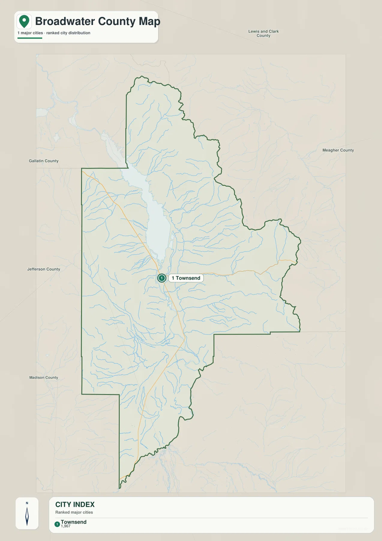
The city map highlights Townsend as the ranked major city and prints a value of 1,967 in its city index. That figure is the value used in the supplied map and should not be treated as a live population estimate. Readers who need current demographic totals should consult recent U.S. Census Bureau releases instead.
Removing most smaller labels makes Townsend’s setting unusually clear. The community lies in the broad lowland between higher terrain to the east and west, with Canyon Ferry Reservoir extending north and the Missouri River continuing south. When this view is compared with the elevation map, the concentration of settlement in the central valley becomes easier to understand.
This particular city map does not draw a connector to another city and does not provide a straight-line or driving distance. Its purpose is therefore positional rather than comparative. Winston, Toston, and The Silos are better located on the general county map, where the smaller road and place labels remain visible.
Canyon Ferry Reservoir feeds directly into the Missouri River corridor
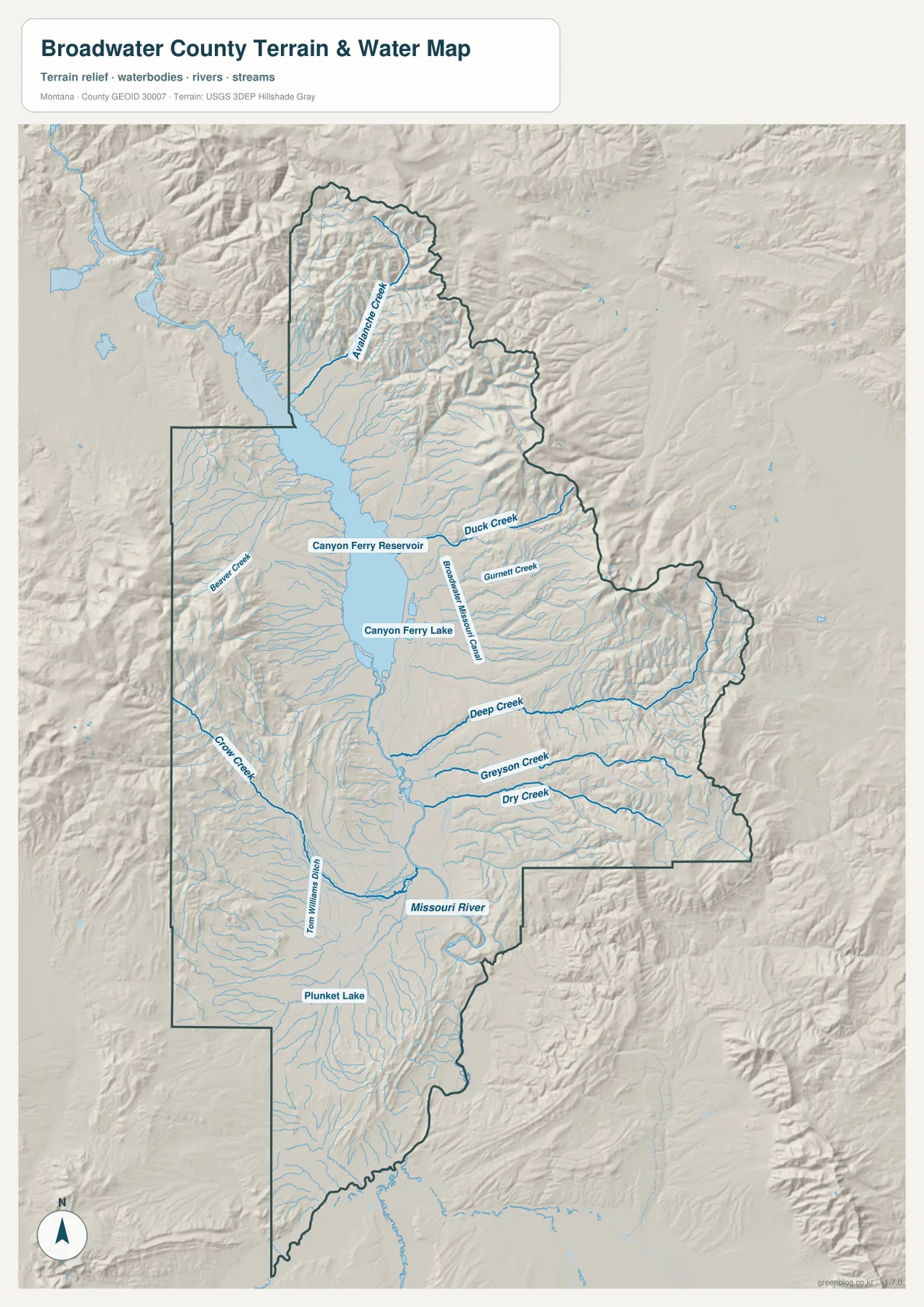
Canyon Ferry Reservoir dominates the northern interior of Broadwater County. Its southern end connects to the Missouri River, which then passes the Townsend area and continues toward Toston. This continuous water corridor is one of the clearest organizing features in the county because the principal lowland, the main highway, and the best-known settlement all occupy roughly the same central strip.
Smaller streams descend toward that strip from both sides. Beaver Creek is labeled west of the reservoir, Avalanche Creek crosses the rugged northern section, and Duck Creek and Gurnett Creek approach from the east. Farther south, Deep Creek, Greyson Creek, and Dry Creek cross the eastern half of the county, while Crow Creek drains part of the western side. Their directions reinforce what the relief suggests: water generally moves from the higher margins toward the lower central valley.
South of Townsend, the Missouri River follows the long lower portion of the county toward Toston. Plunket Lake appears in the southwest as a smaller local water feature, but it is minor compared with Canyon Ferry Reservoir. This map is intended for geographic reference only; it does not define flood zones, navigable channels, parcel boundaries, water rights, or current recreation restrictions.
Toston reveals how far the county continues south of Townsend
The area around Townsend can dominate a first impression because the county is widest there, but the boundary continues a considerable distance south. Toston sits along this narrower southern corridor, close to the Missouri River and U.S. 287. The river valley remains the easiest route through the landscape even as the county becomes narrower and the surrounding ridges close in.
This southern reach is useful for understanding the county’s proportions. Broadwater County is not simply the broad basin around Townsend and Canyon Ferry Reservoir; it also includes the long river section below Townsend. Seeing Toston in relation to the central valley prevents the southern part of the county from disappearing in a quick glance at the map.
Elevation rises from about 1,158 meters to nearly 2,889 meters
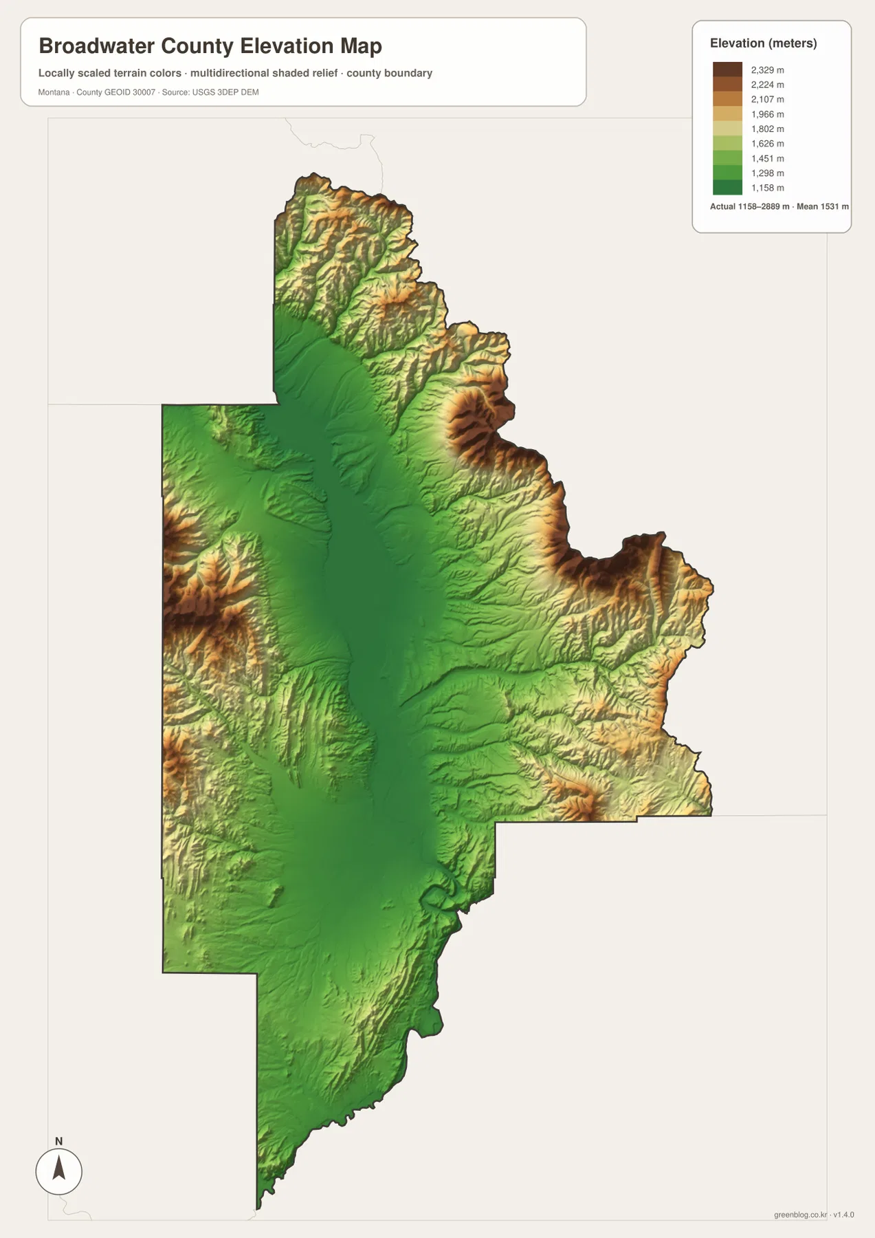
The elevation map reports a county range of about 1,158 to 2,889 meters and a mean elevation near 1,531 meters. Lower green shades follow Canyon Ferry Reservoir, Townsend, and the Missouri River, while higher yellow and brown tones build toward the eastern and western margins. The difference of more than 1,700 meters between the low and high ends of the range explains why the county can contain a broad valley floor and substantial mountain terrain within a relatively compact east-west span.
The east-central part of the county contains one of the strongest concentrations of high relief, and separate high ridges also line the western boundary. Around the reservoir, low ground is narrow in places and gives way quickly to steeper slopes. Comparing this view with the water map shows why streams such as Duck Creek, Deep Creek, and Crow Creek descend toward the center rather than running parallel to the outer ridges.
The southern extension is generally less dominated by the highest terrain, but the Missouri River still occupies the lowest continuous route through that part of the county. Ridges remain on both sides, so the valley stays visually distinct all the way toward the southern boundary. The elevation surface is suitable for county-wide comparison, not for surveying, engineering, or determining the exact elevation of a particular property.
Canyon Ferry Reservoir needs current access information in addition to a static map
Canyon Ferry Reservoir is both a major geographic landmark and an actively managed recreation area. The Silos and Canyon Ferry Airport are shown near its southern side, and the wider reservoir area includes boating, camping, and day-use facilities. The U.S. Bureau of Reclamation provides current information about facilities and operations, which is important because seasonal closures, maintenance, and water conditions can change after a static map is produced.
For trip planning, the county map is useful for understanding how the reservoir relates to Townsend, Winston, surrounding roads, and mountain terrain. It should not be used to determine whether a ramp is open, a campground is operating, or a temporary restriction is in effect. Those time-sensitive details should always be checked through the managing agency before travel.
Frequently Asked Questions
What is the easiest way to locate Townsend and Canyon Ferry Reservoir on the same map?
Start with the general county map. Townsend is near the middle at the U.S. 287 and U.S. 12 junction area, while Canyon Ferry Reservoir extends north from the central valley. The terrain-and-water map is useful next if you want to trace the reservoir into the Missouri River and identify nearby tributaries.
Why are Townsend and the main highways concentrated in the middle of Broadwater County?
The central portion of the county is lower and broader than the mountain terrain along the eastern and western margins. Canyon Ferry Reservoir and the Missouri River occupy the same low corridor, and the principal roads also follow this easier terrain. The elevation and water maps make that relationship especially clear.
Can the 1,158–2,889 meter elevation range be used for a property or engineering project?
No. The range is a county-wide reference for comparing lower valleys with higher terrain. Precise site elevations for construction, property work, or engineering should come from an authoritative source such as the USGS 3D Elevation Program and, when required, a professional survey.
Map File Information
The Broadwater County county, city, terrain-and-water, and elevation maps are provided as high-resolution A3 JPG files.
- Included Files: county map, city map, terrain and water map, elevation map
- File Type: ZIP containing 4 JPG files
Related Maps
Sources and References
Current information for Canyon Ferry Reservoir is available from the U.S. Bureau of Reclamation Canyon Ferry Reservoir page. County boundary and road-reference data can be checked through U.S. Census Bureau TIGER/Line Shapefiles.
Hydrographic reference data are available from USGS National Hydrography, while elevation data can be checked through the USGS 3D Elevation Program.
Green Map creates custom-edited map images using open geographic data sources such as geoBoundaries, Natural Earth, OpenStreetMap, and government open data. These maps are edited visual materials, not raw data files, and are provided for education, documents, presentations, and graphic reference.