Fayette County is centered on Lexington-Fayette, a large urban area surrounded by rural roads, creeks, reservoirs, and rolling ground near the county edges. The maps on this page make it possible to compare the county boundary, major roads, the dominant city location, named waterways, and relative elevation. The original high-resolution JPG files are also available together in the download box below.
A useful way to orient yourself is to begin with Lexington-Fayette and then move outward. Roads are densest around the urban core, while named creeks become stronger reference points toward the north and east. The southern edge has a different character because the land drops into the Kentucky River valley, creating a noticeable contrast with the higher interior.
Table of Contents
Start with Lexington-Fayette before tracing the county edge
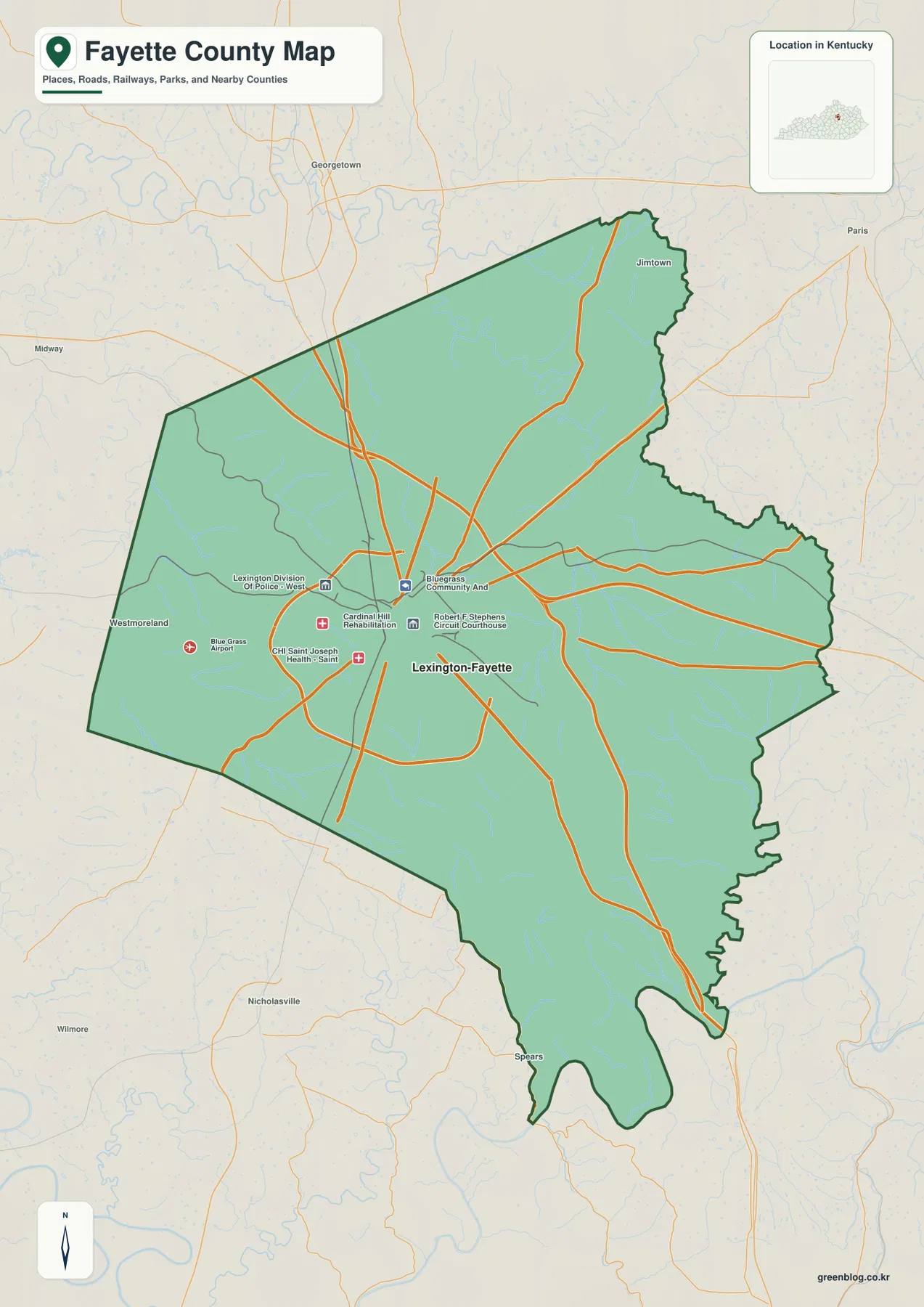
Lexington-Fayette is by far the strongest place label on the county map. The central and western urban area also contains several prominent facilities, including Blue Grass Airport, medical facilities, and the Robert F. Stephens Circuit Courthouse. Roads converge around the city and then spread outward toward the county boundary, so the map is easier to understand from the center out than from the outline inward.
Nearby cities outside the county help establish regional context. Georgetown lies to the north, Paris to the northeast, Nicholasville to the south, and Midway to the west. Those surrounding labels show where Fayette County sits in central Kentucky while the heavy county line keeps the local area distinct. Once the urban core is located, a road, creek, or reservoir can be used as a second landmark for finding more specific places near the edge.
The city index reflects a county dominated by one urban center
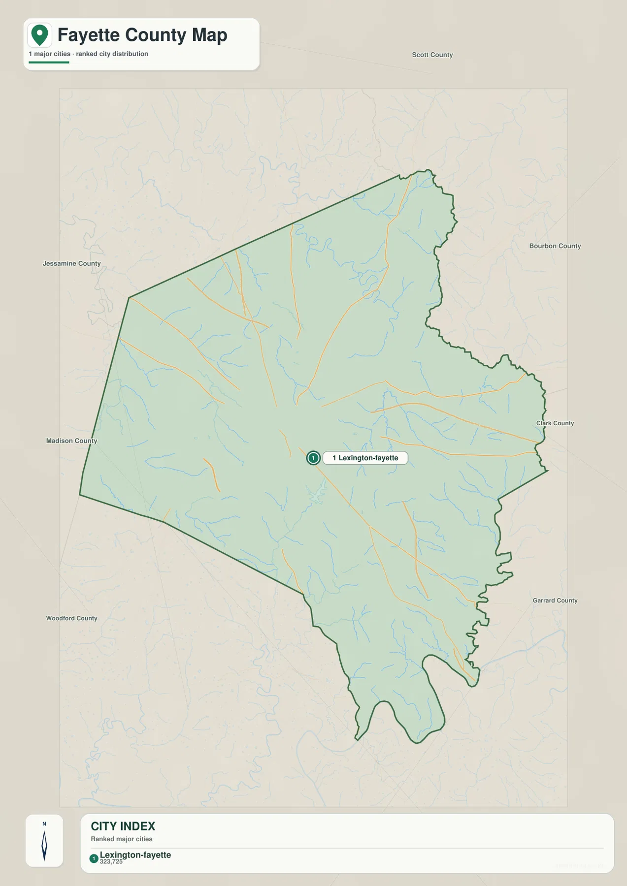
The city map lists Lexington-Fayette as the single major city in the package and shows a reference value of 323,725 in the city index. That number should be treated as the value used by this map package rather than a substitute for the latest population estimate. For current demographic statistics, the U.S. Census Bureau or another current official source is the better choice.
The more useful message of the city view is geographic. Fayette County does not look like a county built around several separate mid-sized towns. Instead, Lexington-Fayette occupies the central role, while the outer county is better understood through roads, streams, reservoirs, and the boundary itself. This also fits the Lexington-Fayette urban-county government structure, which closely links the city and county in local administration.
A dense urban road network gives way to longer rural routes
Around central Lexington, the road network is visually dense and includes routes that cross the city as well as roads that curve around parts of the urban area. Farther out, the pattern opens into longer corridors heading toward the north, east, south, and west boundaries. The west side is also easy to recognize because Blue Grass Airport and several major facilities appear near the urban edge.
For practical orientation, it helps to find the nearest large road first and then match it with a water feature or the shape of the county boundary. A route toward the northeast can be checked against North Elkhorn Creek or Goose Creek, while eastern locations can be compared with Boone Creek or Jones Creek. The map is static, so it should not be used as a source for live traffic, closures, construction changes, or turn-by-turn navigation.
Creek names become especially useful beyond the Lexington core
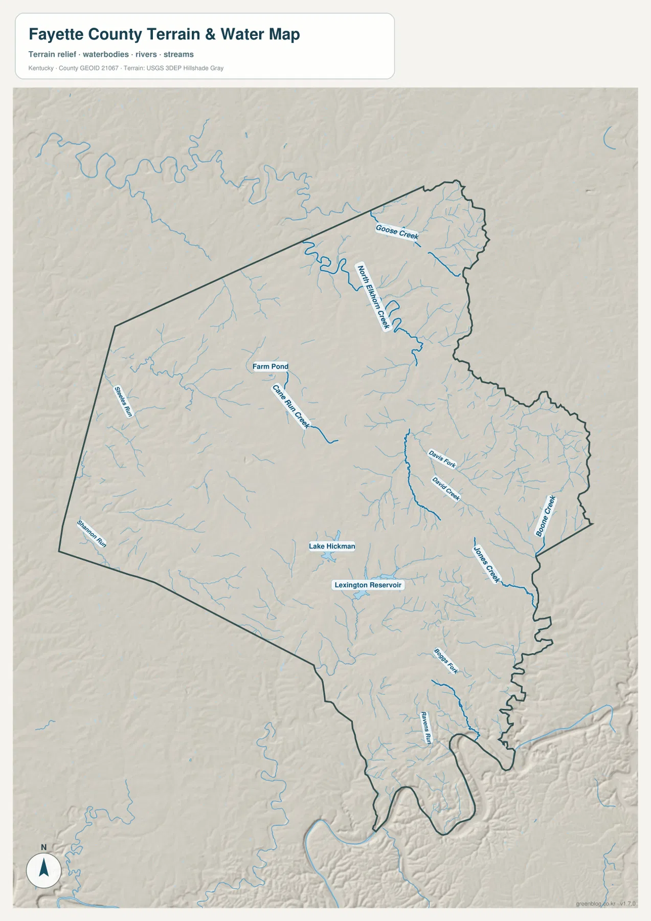
North Elkhorn Creek is one of the clearest water references in northern and northeastern Fayette County. It follows a winding course near the upper part of the county, with Goose Creek labeled nearby. Lexington watershed information also identifies tributaries such as David Fork, Avon Fork, Bryan Station Creek, and Goose Creek within the broader North Elkhorn system, giving the northern part of the county several recognizable stream names.
The eastern side has its own group of useful references. David Creek and Davis Fork appear closer to the middle-east, while Jones Creek and Boone Creek help distinguish areas nearer the eastern edge. To the south, Boone Fork and Ravens Run provide additional water landmarks. Cane Run Creek and Farm Pond are useful on the west-central side, while Lake Hickman and Lexington Reservoir stand out south of the urban core.
This terrain-and-water map is intended for geographic reference rather than hazard or legal decisions. It does not show current flood stages, flood insurance zones, water quality, navigation status, or property ownership. For those questions, current information from the appropriate agency is required. The map is most useful for understanding where named streams and reservoirs lie in relation to roads, the county boundary, and the surrounding terrain.
The lowest terrain is concentrated along deeper river and creek valleys
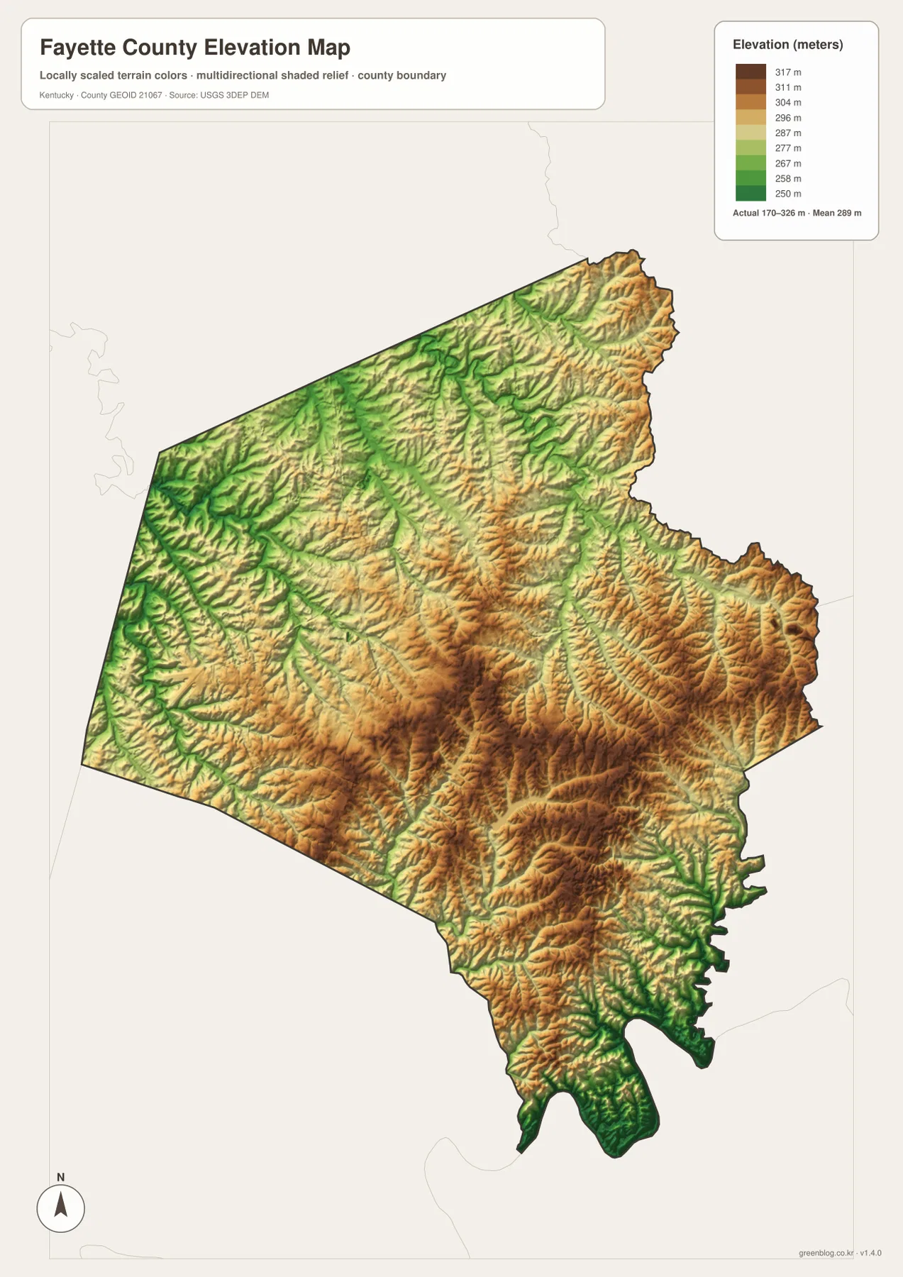
The elevation map shows an actual mapped range of about 170 to 326 meters, with a mean of 289 meters. Much of the central and eastern interior appears as higher rolling ground, while green lower corridors follow streams and valleys. The most striking low area is along the southern edge, where the land drops toward the Kentucky River valley.
Lower strips also follow smaller drainage corridors in the west and north, but they are less dramatic than the southern river valley. Lexington itself sits within rolling terrain rather than on a single perfectly flat surface. That helps explain why the county map can show places that are close in straight-line distance while roads still curve around creek valleys or follow more favorable ground.
The elevation colors are designed to compare relative height across the county, not to provide survey-grade measurements for individual properties. Engineering, construction, drainage design, and exact site elevations require more detailed elevation data or professional surveying. For county-scale orientation, however, the map clearly shows the contrast between lower valleys and the higher central and eastern uplands.
Use roads, waterways, and relief together when locating the outer county
Fayette County is easier to navigate on paper when two or three types of landmarks are combined. In the northeast, for example, a road leaving Lexington can be followed until it approaches North Elkhorn Creek or Goose Creek. In the east, Boone Creek and Jones Creek provide different references. Along the south, the lower terrain leading toward the Kentucky River gives another clue that is easy to verify on the elevation view.
The west side can be approached from Blue Grass Airport and Cane Run Creek, while Lake Hickman and Lexington Reservoir are useful south of central Lexington. These references are particularly helpful because the county does not present a long chain of separately ranked towns. The urban center is dominant, and the outer landscape is more effectively distinguished by roads, streams, reservoirs, and terrain.
Choose the file that matches the question you need to answer
The county map is the best starting point for boundaries, major roads, surrounding cities, and prominent facilities on one page. The city map strips the picture down to the dominant urban reference and works well when the main question is how Lexington-Fayette relates to the county. The terrain-and-water map is better for named creeks and reservoirs, while the elevation map makes the lower valleys and higher rolling ground easiest to compare.
The downloadable archive contains the original high-resolution JPG versions of the county map, city map, terrain-and-water map, and elevation map shown here. These larger files are useful when labels need to be enlarged or when preparing an A3 print. Because all four files use the same Fayette County boundary, they can be placed side by side without having to reconcile different extents.
Frequently Asked Questions
What is the best first reference point on a Fayette County map?
Lexington-Fayette is the easiest starting point because it dominates the center of the county and is surrounded by the densest concentration of roads and major facilities. From there, you can follow a road outward and use a creek, reservoir, airport, or county-boundary shape as a second reference.
Are North Elkhorn Creek and Boone Creek in the same part of the county?
No. North Elkhorn Creek is a strong reference in the northern and northeastern part of Fayette County, with Goose Creek nearby. Boone Creek appears along the eastern side and works with Jones Creek as a useful landmark for the outer eastern area.
Where does the elevation map show the clearest low ground?
The most obvious low terrain is along the southern edge where the county drops toward the Kentucky River valley. Lower corridors also follow smaller streams elsewhere, while much of the central and eastern interior is higher rolling ground. The 170–326 meter map is for relative terrain comparison, not engineering or survey measurements.
Map File Information
The ZIP contains the original high-resolution JPG files for the four Fayette County maps described on this page.
- Included Files: county map, city map, terrain and water map, and elevation map
Related Maps
Sources and references
County boundaries and geographic reference data can be checked through the U.S. Census Bureau TIGER/Line program. Local government context is available from the Kentucky Department for Local Government Fayette County profile and the Lexington-Fayette Urban County Government website.
Water features can be referenced through USGS National Hydrography and Lexington’s official watershed information. Elevation reference data are available through the USGS 3D Elevation Program.
Green Map creates custom-edited map images using open geographic data sources such as geoBoundaries, Natural Earth, OpenStreetMap, and government open data. These maps are edited visual materials, not raw data files, and are provided for education, documents, presentations, and graphic reference.