McDonald County occupies Missouri’s far southwestern corner, where a cluster of towns and highways on the west side meets a much more deeply dissected Ozark landscape to the east. Pineville, Anderson, Noel, Goodman, Lanagan, and Southwest City provide useful reference points, while the Elk River and the Big and Little Sugar Creek valleys explain much of the shape of the terrain between them. This page separates those features into road, city, water, and elevation views so they can be compared without crowding everything onto one image. A download box later on the page provides the four A3 high-resolution JPG originals for printing, close inspection, or offline reference.
A practical way to begin is to find Pineville and then follow U.S. 71 north toward Anderson and Goodman. From there, look west toward Lanagan and Noel, then east along Routes 76 and 90 into country with fewer large settlements and more closely spaced ridges and hollows. The water and elevation maps add the part that a standard road map cannot show as clearly: the county drops into broad western river valleys but rises into rougher high ground across the east and southeast, with the mapped elevation ranging from about 228 to 447 meters.
Table of Contents
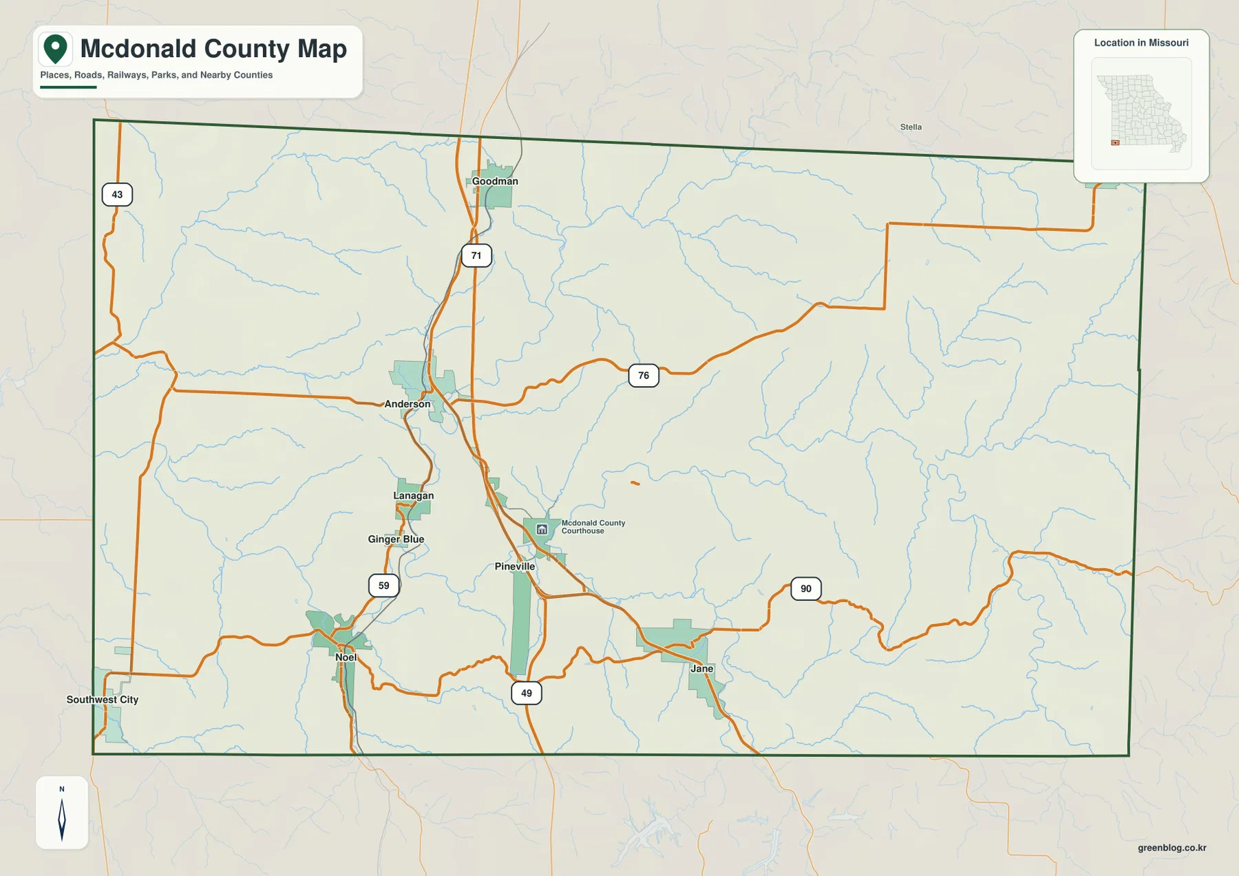
Start with Pineville, U.S. 71, and the county’s main road references
U.S. 71 is the easiest road to use as an organizing line on the county map. It enters the northern part of McDonald County near Goodman, passes the Anderson area, and continues south toward Pineville. Anderson also sits near the junction with Route 76, which heads east into a less settled part of the county. South of Pineville, Route 49 continues toward the state line, while Route 90 crosses the southern half of the county and passes the Jane area before continuing through the eastern hills. These roads make it possible to place the towns in relation to one another before turning to the more detailed stream and relief patterns.
Pineville is marked with the McDonald County Courthouse, making it an especially useful anchor for readers who want to connect the map to county government. Lanagan lies to the west-northwest of Pineville near Route 59, and Noel is farther south along the same general western corridor. Route 43 appears near the western edge, while Southwest City sits close to the county’s southwestern corner. The road network therefore does not form a simple central grid. Major routes bend around valleys and towns, and the eastern half has longer stretches between the highlighted communities.
The county outline also helps explain why outside destinations can lie in very different directions even when they are not far away in straight-line distance. McDonald County is at the corner of Missouri, with Newton County to the north and Barry County to the east, while state boundaries lie along the west and south. The map is useful for geographic orientation, but it is not a live navigation product. Road closures, construction, weather, and travel times should be checked through current transportation or navigation sources before a trip.
Why the highlighted towns cluster in the western valleys
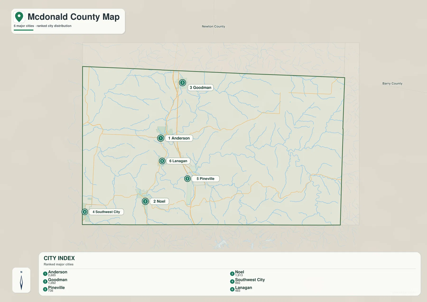
The city map highlights six places: Anderson, Noel, Goodman, Southwest City, Pineville, and Lanagan. Their distribution is immediately uneven. Goodman and Anderson line up in the northwestern part of the county close to U.S. 71. Lanagan and Noel sit farther south and west, Pineville occupies a more central-western position, and Southwest City is near the southwestern corner. The eastern half of the county has no comparable concentration of highlighted towns on this map. That empty-looking space becomes much more informative when it is compared with the water and elevation views.
Noel is a good example of the connection between settlement and the valley floor. On the city map it appears simply as one of the larger marked communities, but the water map places it beside the Elk River corridor. Lanagan and Pineville also occupy terrain cut by streams rather than the higher eastern ridges. The western side offers longer connected lowlands, whereas the east is broken into many short ridges and narrow hollows. The maps do not prove why every town developed where it did, but they make the physical setting of the present-day settlement pattern easy to see.
This city view is best for locating communities quickly because it removes much of the road and terrain detail. It should not be treated as a complete list of every settlement, neighborhood, or mailing address in McDonald County. Smaller places and individual properties require a more detailed local map. For a reader deciding where a named town sits within the county, however, the simplified markers provide a cleaner comparison than the general map.
Follow the Elk River and the two Sugar Creeks across the county
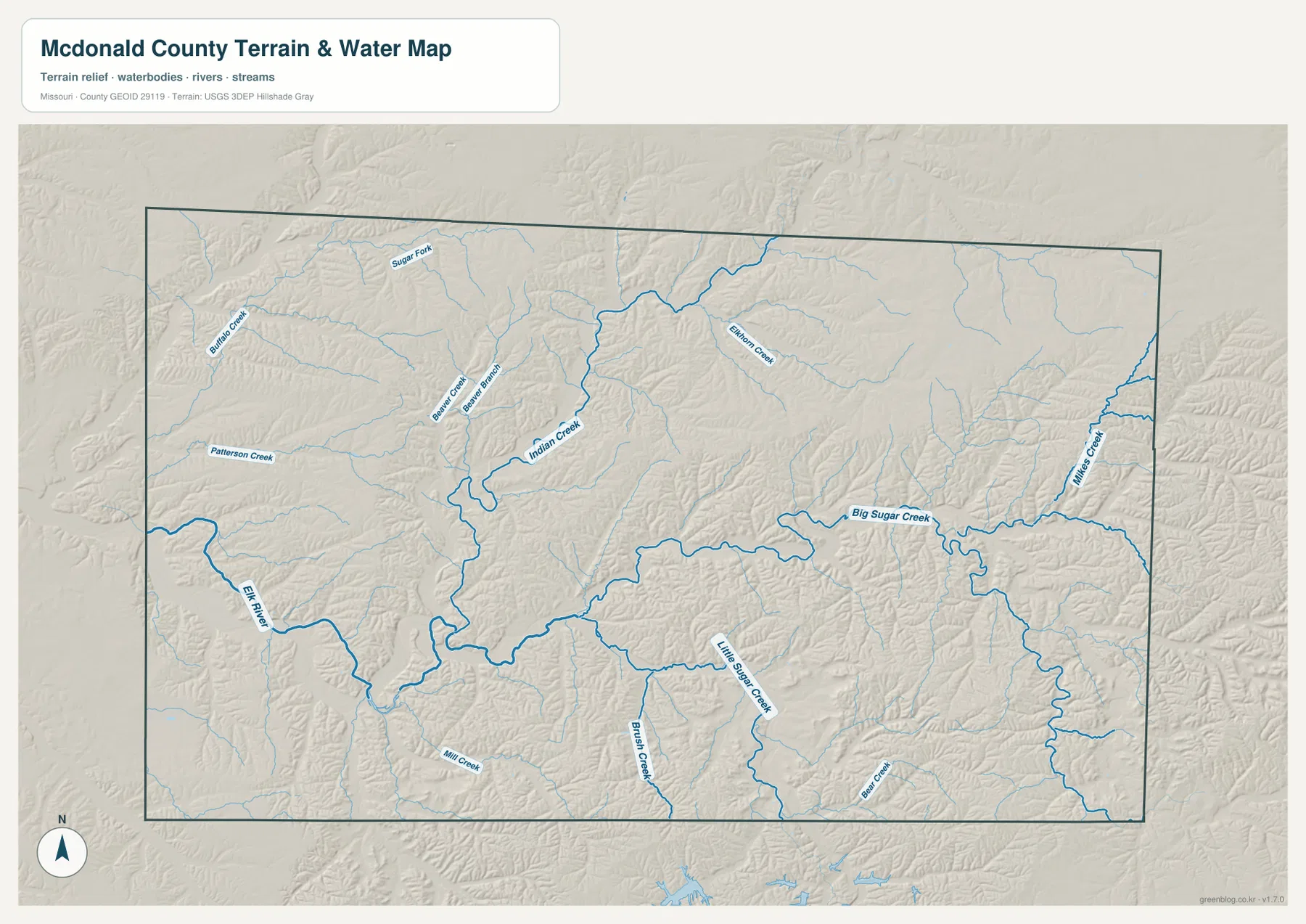
The terrain-and-water map reveals a dense network of streams cutting through McDonald County. The Elk River is one of the most prominent waterways on the west side, curving through a broad valley before leaving the county. Big Sugar Creek approaches from the east and southeast through a long, winding valley, while Little Sugar Creek occupies another major corridor to the south. Their paths are not straight because they follow lower ground between Ozark ridges. When these waterways are viewed together, the western half of the county looks like a meeting place for several valleys rather than a flat plain.
The map also labels smaller streams that help fill in the geography between the best-known rivers. Buffalo Creek and Patterson Creek appear in the northwest, with Beaver Creek, Beaver Branch, Indian Creek, and Sugar Fork nearby. Brush Creek and Bear Creek lie farther south, while Mikes Creek is marked in the eastern part of the county. These names are useful when a location is described by a creek rather than by a town or highway. They also show just how frequently the land is divided by drainage channels, especially in the higher eastern terrain.
Big Sugar Creek is particularly useful for comparing water with relief. It begins in higher country and follows a sinuous path westward through a succession of narrow valleys. Little Sugar Creek traces a similar lower route farther south. On the elevation map, both corridors stand out as lower green bands surrounded by higher slopes. That relationship makes the water map more than a list of stream names: it helps explain why roads and settlements often favor certain valleys and why cross-country travel can involve repeated climbs and descents.
Natural areas such as Big Sugar Creek State Park also reflect the importance of these wooded creek valleys to the county’s landscape. Anyone planning hiking, paddling, or other outdoor activity should still consult current park information, weather, and water conditions. The map is intended to show geographic relationships, not to certify access, river stage, trail condition, or safety on a particular day.
From low western valleys to 447-meter high ground in the east
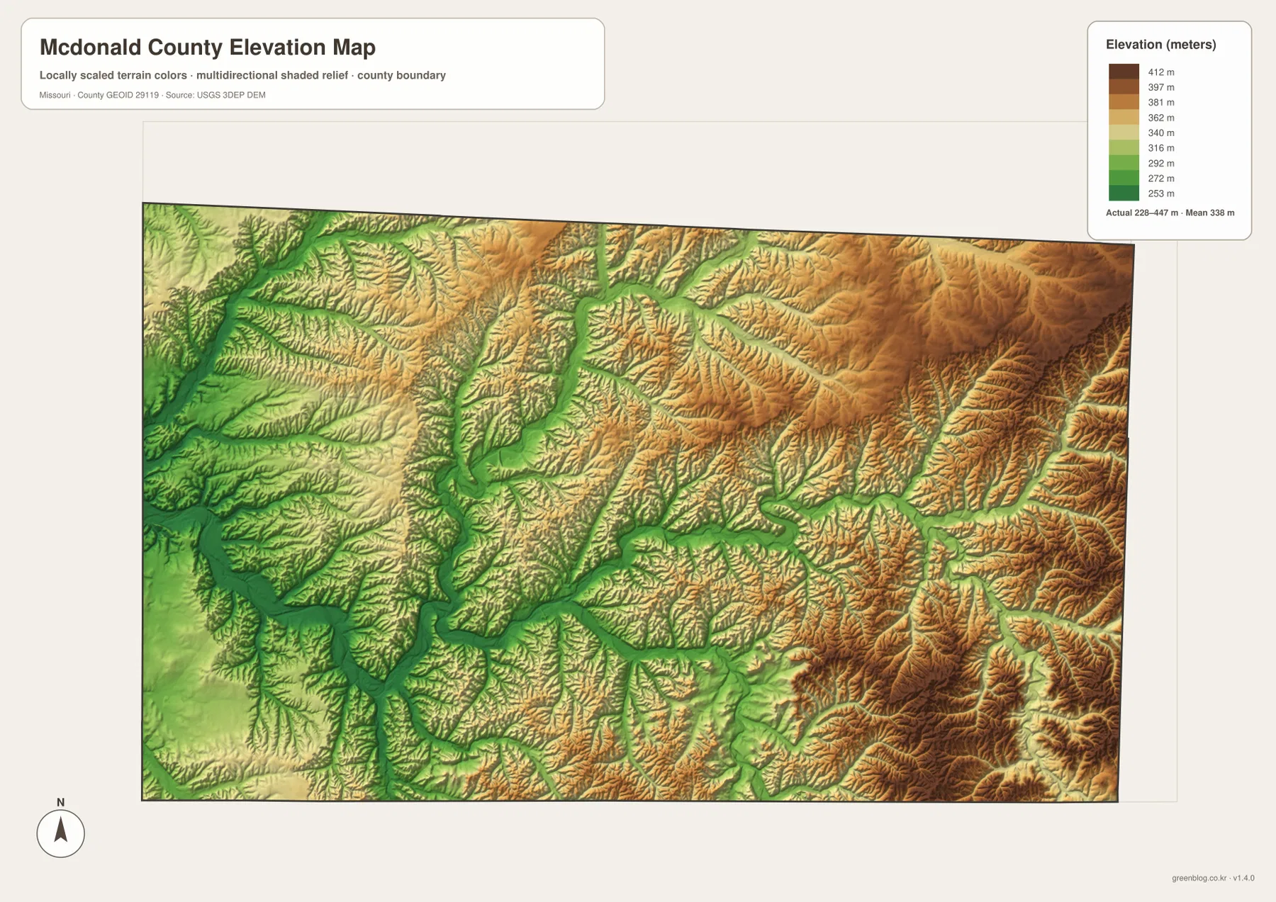
The elevation map gives McDonald County an entirely different appearance from the road map. Its stated actual elevation range is about 228 to 447 meters, with a mean near 338 meters. Lower greens are concentrated along the major western valleys and in the channels that reach into the interior. Higher tan and brown tones become more extensive toward the east and southeast. The result is not a smooth ramp rising from west to east; streams have cut deeply into the uplands, leaving a repeating pattern of narrow valleys and branching ridges.
The Elk River corridor is easy to recognize as a broad lower area on the western side. Similar green ribbons reach upstream along tributaries, showing that the low ground follows water rather than county or road boundaries. Around Pineville, Noel, and the western town corridor, lower terrain is more continuous. Farther east, the valleys become narrower and high ground occupies more of the space between them. The relief becomes especially pronounced toward the eastern and southeastern margins, where ridges stand well above nearby creek bottoms.
This topography helps explain why the road map contains so many curves outside the main U.S. 71 corridor. A road crossing the eastern Ozarks must work around slopes, hollows, and stream crossings, so straight-line distance can be a poor guide to actual travel. Route 90 provides a useful visual example because it runs from the more settled southern-central area toward Jane and the rugged east. The elevation map does not give road grades, but it makes the surrounding relief visible enough to show why a route across the county can feel very different from a trip along a broad western valley.
For an exact spot elevation, survey work, flood analysis, or engineering use, readers should consult the underlying USGS elevation and hydrography products rather than estimate from the colors in this illustration. The color scale is designed for comparison across the county, not for replacing site-specific measurements. Its main value here is to connect the stream network with the larger shape of the land.
Compare Noel, Pineville, and Jane across all four views
Noel demonstrates why using more than one map can change the way a place is understood. In the general county view, it is a town near Route 59 in the southwest. The city map makes its position relative to Anderson, Pineville, and Southwest City easier to judge. On the water map, the Elk River becomes the dominant nearby feature, and the elevation view confirms that the community sits in a broad low corridor compared with the higher land to the east. Each map answers a different question without requiring the others to repeat the same information.
Pineville works as another useful comparison point. The county map identifies the courthouse and shows the main roads around the community. The city view places it between the northern Anderson-Goodman corridor and the southern settlements. The stream map shows a web of tributaries and valleys around the area, while the elevation map places Pineville near the transition between broad western lowlands and more broken upland terrain. Its role as the county seat is administrative, but its mapped setting is strongly tied to the same valley system that organizes much of western McDonald County.
Jane illustrates the opposite problem: not every useful reference point appears among the six ranked cities. It is labeled on the general map along Route 90 in the southern part of the county, east of Pineville. From Jane eastward, large-town labels become sparse while ridges, branches of Big Sugar Creek, Mikes Creek, and higher terrain become more important for orientation. A reader searching this area may therefore get more value from combining the general, water, and elevation maps than from relying on the city index alone.
- Road and boundary context: use the general county map.
- Quick town-to-town comparison: use the city map.
- River and creek relationships: use the terrain-and-water map.
- Valleys, ridges, and relative height: use the elevation map.
The WebP images in the article are optimized for browser viewing. They are convenient for quickly checking where a road, town, stream, or ridge lies, but the downloadable JPG versions are better when small labels need to remain legible at a larger size. The archive contains the general county map, city map, terrain-and-water map, and elevation map as A3 high-resolution JPG files. They can be used independently, so there is no need to print every map when only one theme is relevant.
For printing, keep the original aspect ratio and allow for printer margins instead of stretching the image to fill the page. A3 paper preserves more label detail than a small sheet, especially on the stream and elevation maps. For presentations or web publishing, resizing from the original JPG generally produces a cleaner result than enlarging a browser preview. The files are geographic reference graphics rather than live navigation or emergency maps, so current transportation, weather, access, and hazard information should always come from the relevant official source.
Frequently Asked Questions
Which map is best for understanding the Elk River and Big Sugar Creek?
Start with the terrain-and-water map because it shows the Elk River, Big Sugar Creek, Little Sugar Creek, and their tributaries together. Then compare it with the elevation map to see that the major waterways occupy lower valleys between higher Ozark ridges. That second view is especially helpful in the eastern half, where the stream network is dense and the relief is stronger.
What is the easiest way to compare Anderson, Pineville, and Noel?
The city map is the fastest way to compare their positions because the highlighted communities are clearly marked and much of the extra detail is removed. If you also need the highways, switch to the general county map to see U.S. 71 and Route 59. For Noel, the terrain-and-water map adds important context because the Elk River valley is a major part of the town’s setting.
What is included in the download ZIP?
The ZIP contains four A3 high-resolution JPG originals: the general county map, city map, terrain-and-water map, and elevation map. They are intended for larger viewing and printing than the WebP previews in the article. They do not provide live traffic, road closure, river-stage, or emergency information.
Map File Information
The archive contains the McDonald County general, city, water, and elevation maps as A3 high-resolution JPG originals.
- Included Files: Use only the versions confirmed in the article and supplied images
- File Type: Use the confirmed download contents
- Intended Use: Printing, education, presentations, and map-based projects
Related Maps
Sources and reference links
For current county information and the official datasets behind boundary, hydrography, and elevation references, use the following sources.
- McDonald County, Missouri official website
- Visit Missouri – Big Sugar Creek State Park
- U.S. Census Bureau TIGER/Line Shapefiles
- USGS National Hydrography
- USGS 3D Elevation Program
Green Map creates custom-edited map images using open geographic data sources such as geoBoundaries, Natural Earth, OpenStreetMap, and government open data. These maps are edited visual materials, not raw data files, and are provided for education, documents, presentations, and graphic reference.