Madison County occupies a hilly part of southeastern Missouri, with Fredericktown providing the clearest starting point for finding roads and communities between the St. Francis River on the west and the Castor River side of the county on the east. The maps on this page combine county boundaries, highways, four highlighted communities, streams and lakes, and a relief surface ranging from about 131 to 457 meters. High-resolution JPG versions are available in the download box later in the article for printing or offline reference.
The county makes more sense on a map when it is viewed as a series of valleys and ridges instead of a broad, level rural plain. Fredericktown, Junction City, and Cobalt form a compact cluster in the north-central area, while Marquand sits well to the southeast. That separation becomes more meaningful when the city map is compared with the water and elevation views, because each group occupies a different mix of roads, tributaries, and uplands.
Table of Contents
Roads and communities around Fredericktown
On the general county map, Fredericktown is the easiest place to use as a reference point. U.S. 67 runs north and south through the county and continues toward Cherokee Pass, while Missouri Route 72 crosses the Fredericktown area and extends eastward. A dense set of smaller numbered roads fills the space between those routes, including roads labeled 217, 219, 208, 404, 411, 423, 303, 310, 315, 320, and 313 on the supplied map.
Mine La Motte appears just north of Fredericktown, and Cobalt lies close to the south side of the same developed cluster. Cherokee Pass is farther down the U.S. 67 corridor. Marquand is different: it sits near the southeastern side of the county, separated from the Fredericktown group by a broad interior of hills, creeks, and local roads. That arrangement puts much of the named settlement activity near the north-central part of the county while leaving Marquand clearly separated to the southeast.
The outer boundary also helps identify where Madison County fits within southeast Missouri. St. Francois County is to the north, Wayne and Iron counties are on the western side, Ste. Genevieve County touches the southwest, and Bollinger and Perry counties are on the east. The outline includes several bends rather than forming a perfect rectangle, especially toward the northwest and along the eastern edge.
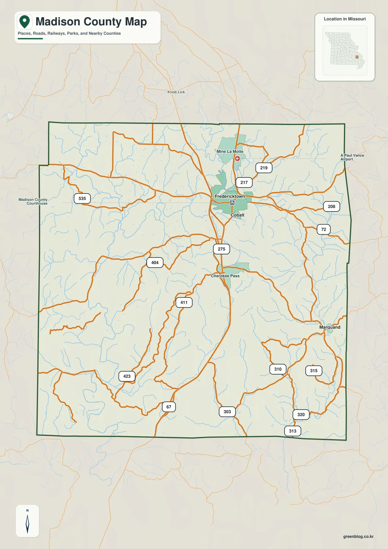
For orientation, this is the most complete of the supplied map views because it keeps roads, place labels, streams, and neighboring counties together. It is useful for answering basic questions such as whether a community lies north or south of Fredericktown, which highway provides the broad corridor through the county, or which neighboring county lies beyond a given edge. It is not designed to replace turn-by-turn navigation, live traffic data, or legal boundary records.
Fredericktown’s importance is not just visual. Madison County’s official government site lists the county courthouse at Courthouse Square in Fredericktown, reinforcing its role as the administrative center. Missouri Department of Transportation mapping also identifies U.S. 67, Business 67, and Route 72 in and around the city. Those references fit the pattern visible on the county map: a central service community positioned where several important routes converge.
Fredericktown, Junction City, and Cobalt near the center, with Marquand farther southeast
The city index simplifies Madison County to four ranked communities: Fredericktown, Junction City, Cobalt, and Marquand. The printed figures on the supplied map are 4,507 for Fredericktown, 372 for Junction City, 364 for Cobalt, and 187 for Marquand. Those values are best treated as the index used by this map rather than as a substitute for a current demographic profile, but they make the relative scale of the four places immediately clear.
Fredericktown is overwhelmingly the largest of the four, while Junction City and Cobalt are much smaller and sit close to it. Junction City is northeast of Fredericktown and Cobalt is just to the south-southeast, so all three can be located within a compact part of the county. Marquand stands apart in the southeast, making it the easiest place to use when explaining how settlement spreads beyond the Fredericktown-centered road network.
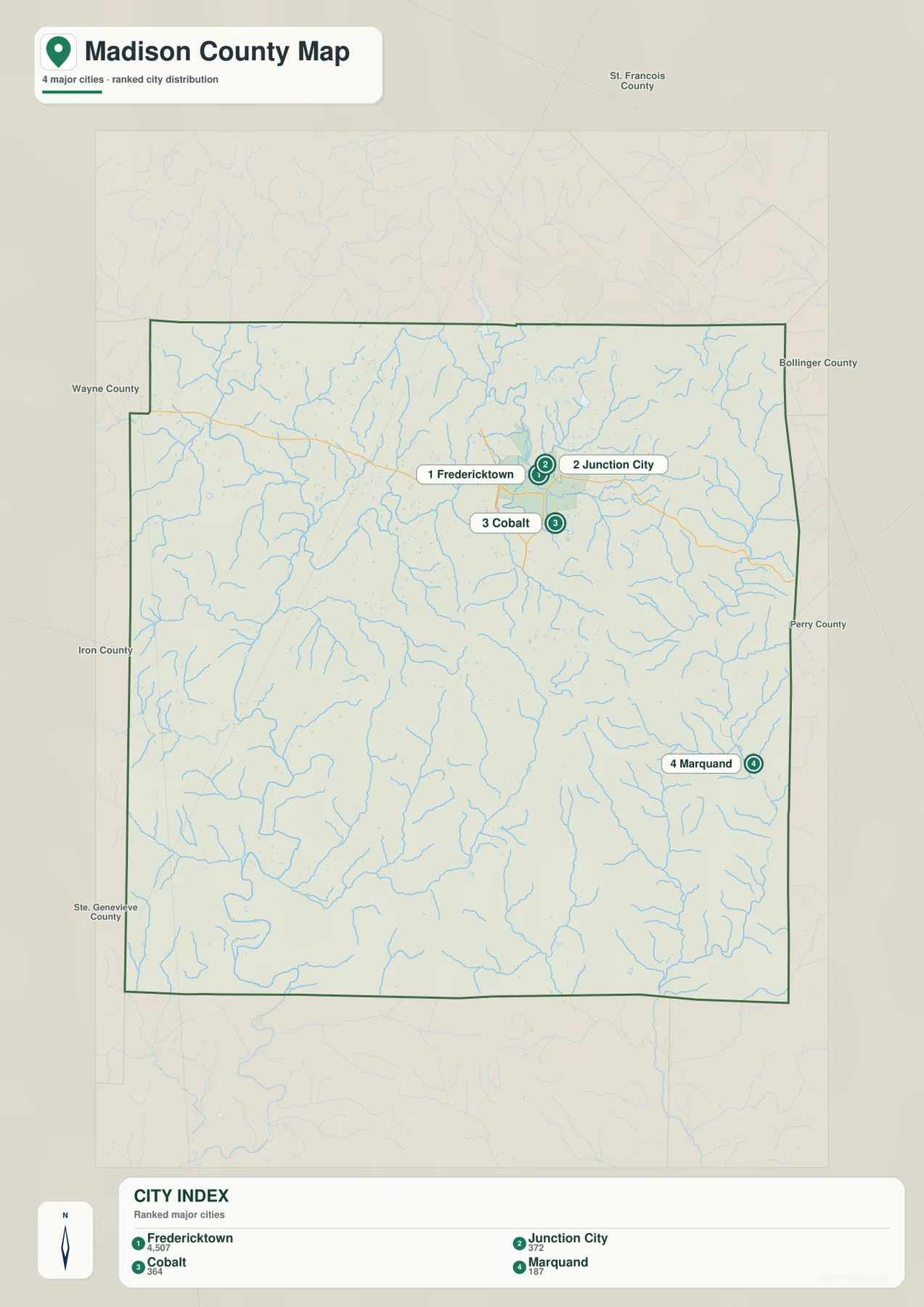
This map is intentionally simpler than the general county map. It works well when a reader needs to find the four highlighted communities without the visual competition of every road label. The apparent spacing should not be read as a driving-distance chart; roads bend around ridges and cross numerous streams, so actual travel mileage can differ noticeably from the straight visual gap between two labels.
Mine La Motte and Cherokee Pass are useful examples of why the two map types should be used together. Both are labeled on the general map, yet they are not part of the four-place city index. A search for a specific community therefore starts with the simplified city view only when that place is included there; otherwise, the broader county map provides the necessary context.
Marquand also demonstrates how settlement and physical geography interact. It lies closer to the eastern drainage network than the Fredericktown cluster does, with the Castor River and many small tributaries occupying that side of the county. The city map shows the separation first; the water map explains the landscape occupying the space between the communities.
St. Francis River to the west and Castor River waters to the east
The terrain and water map reveals that Madison County is crossed by far more small drainage lines than the general road view suggests. The St. Francis River follows the western and southwestern side of the county, while the Little St. Francis River descends through the northern interior. On the eastern side, the Castor River forms a long, distinct corridor. Between these larger rivers, Trace Creek, Twelvemile Creek, and many unnamed tributaries divide the hills into smaller valleys.
The mapped lakes are scattered rather than concentrated in one reservoir district. Nims Lake, Mine La Motte Lake, Lost Valley Lake, and Slime Pond appear in the north. Blue Mountain Lake is farther west, while Newman Lake and Brown Lake sit in the eastern half. Their distribution reinforces the impression that water features occur throughout the county even though no single lake dominates the map.
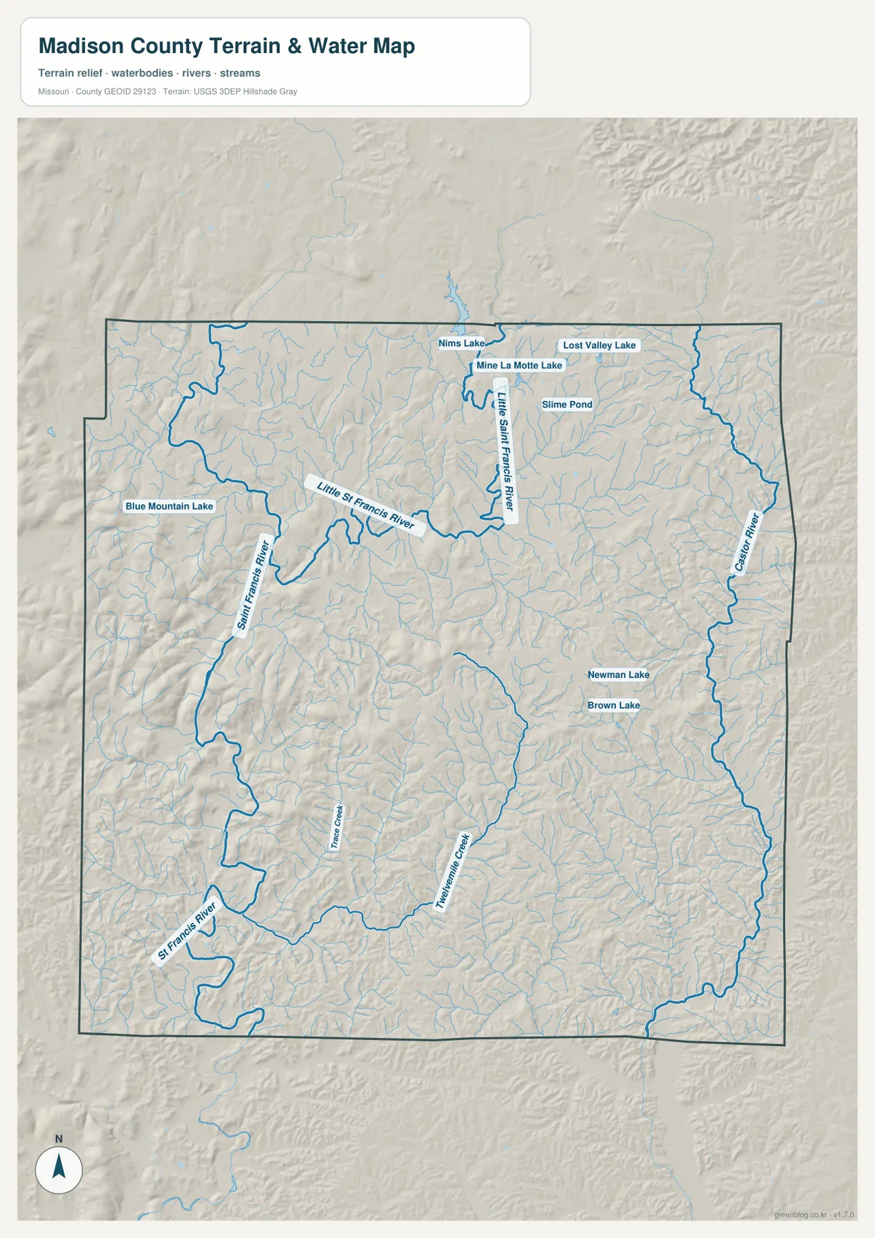
A county-specific example can be found west of Fredericktown at Millstream Gardens Conservation Area. The Missouri Department of Conservation places the 916-acre area in Madison County along Route 72 and describes the St. Francis River passing through the Tiemann Shut-ins before continuing toward the Silver Mines area. That setting matches the supplied map’s western river corridor, where the main channel is surrounded by tightly folded terrain rather than broad open lowland.
The northern water pattern is different. The Little St. Francis River and nearby lakes occupy the country around Mine La Motte and north of Fredericktown, with many small tributaries approaching from both sides. The east has another pattern again, because the Castor River forms a long north-south boundary-side corridor and Twelvemile Creek drains part of the southeastern interior.
The water map is a geographic reference, not a flood-hazard or boating-safety product. River stage, depth, access, and current conditions can change, and a line on this map does not establish whether a stream crossing is safe or a property is within a regulated floodplain. For recreation or hazard planning, current information from the appropriate managing agency should be used alongside the map.
Low river valleys and higher Ozark ridges from 131 to 457 meters
The elevation map gives Madison County a very different appearance from a conventional road map. Its legend reports an actual range of approximately 131 to 457 meters and a mean elevation of 245 meters. Greens mark the lower corridors, while yellow, tan, and brown tones identify higher ridges and hills. The contrast is strong enough that the drainage network can often be inferred even before individual stream names are checked.
Higher ground is especially conspicuous in the west and northwest. The St. Francis River winds through lower green corridors bordered by ridges that rise sharply in color on both sides. Additional high terrain appears across the north and northeast, while the central part of the county contains broader areas of moderate elevation cut by numerous narrow valleys.
The eastern side is not simply flat low country. The Castor River creates a long lower corridor, but its tributaries cut repeatedly into higher ground to the west. Twelvemile Creek and nearby branches create another set of low fingers in the southeast. Around Marquand, this produces a landscape of closely spaced valleys and ridges rather than one continuous plain.
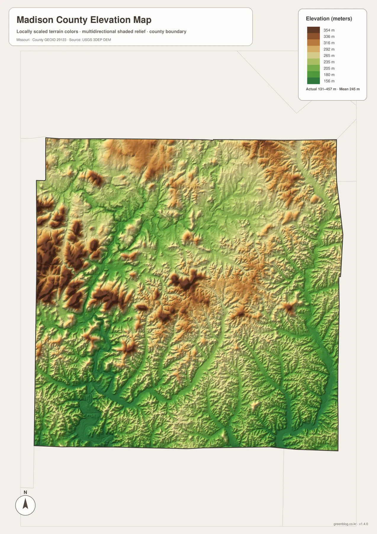
Comparing the elevation and water maps is particularly useful along the St. Francis River. The blue river line occupies a green low corridor, and surrounding ridges switch quickly to warmer elevation colors. The Tiemann Shut-ins area described by the Missouri Department of Conservation is a strong real-world example of why this western side feels more rugged than a simple county outline might suggest.
Fredericktown occupies a useful middle position for reading the county. It is not located on the most extensive high ridge or at the lowest mapped valley, but it sits close to several small drainage lines and road corridors that lead into very different terrain. Travel west brings the St. Francis River hills into view, while movement east and southeast approaches the Castor and Twelvemile drainage country.
The same comparison clarifies why a straight road grid is difficult to maintain across much of Madison County. Numerous creeks occupy low channels, and the ground rises again between them. Major roads can cross these features, but smaller local roads often bend or change direction as they connect ridges, valleys, and settlements. The elevation map therefore adds physical context to road shapes that may look arbitrary on the general map.
This shaded elevation surface is generalized for regional comparison. It should not be used as survey-grade elevation for a parcel, building site, drainage design, or engineering project. Its purpose here is to show where lower valleys and higher uplands are concentrated and to help readers connect that relief with the rivers, roads, and communities shown on the other maps.
Which Madison County map to use for roads, towns, water, or relief
Start with the general county map when the question is primarily about location. It is the best single view for finding Fredericktown, Mine La Motte, Cobalt, Cherokee Pass, Marquand, U.S. 67, Route 72, and the neighboring county boundaries. Once the target place is located, another map can answer a more specific question without forcing every layer of information onto one page.
The city map is the cleaner choice for comparing the four highlighted communities. It makes Fredericktown’s relative dominance and the separation of Marquand immediately obvious. The terrain and water view is more useful for locating the St. Francis, Little St. Francis, and Castor river systems, while the elevation view explains which of those corridors occupy lower ground and where the larger ridges rise.
For teaching or document preparation, pairing maps can be more informative than relying on one image. A road-and-settlement exercise can use the county map beside the city index, while a physical-geography exercise can compare the water map with the colored relief surface. Because the same county boundary anchors every version, readers can move from one subject to another without having to relearn the overall shape.
The WebP images in the article are optimized as on-page previews. The downloadable originals are JPG files measuring 3638 by 2572 pixels each, which provides more room for printed labels and document layouts. The archive contains the general county map, city map, terrain and water map, and elevation map.
What these maps can show—and what should be checked elsewhere
These maps are intended for geographic orientation, printing, education, and general reference. They do not establish parcel ownership, legal boundary monuments, zoning, engineering elevations, or emergency routing. County administrative questions should be checked with Madison County government, while current highway conditions and construction information are better handled through Missouri Department of Transportation resources.
The same caution applies to rivers and outdoor recreation. A mapped channel identifies a water feature but does not report current stage, current, access restrictions, or flood hazard. Millstream Gardens and the St. Francis River are managed environments with site-specific information, so the Missouri Department of Conservation is the more appropriate source when a visitor needs current rules or conditions.
For boundary and terrain datasets, the U.S. Census Bureau’s TIGER/Line resources, USGS National Hydrography information, and the USGS 3D Elevation Program provide authoritative starting points. These sources are useful when a general printable map needs to be followed by more detailed GIS or data work.
Frequently Asked Questions
Which maps are most useful for the St. Francis River and nearby hills?
Use the terrain and water map first to follow the St. Francis River, then compare the same area on the elevation map. The river occupies a lower green corridor while higher ridges rise on both sides, especially in the western part of the county. That pairing is also useful for understanding the setting of Millstream Gardens and the Tiemann Shut-ins area.
How can I compare Fredericktown and Marquand quickly?
The city map gives the simplest comparison because it isolates the highlighted communities and shows Fredericktown in the north-central cluster while Marquand sits well to the southeast. The general county map should be the next step when you need the road connections, and the water or elevation map can add physical context to the space between them.
Which downloadable files are included for printing?
The ZIP archive contains four high-resolution JPG files: the general county map, city map, terrain and water map, and elevation map. Each original image measures 3638×2572 pixels, so the downloaded versions retain more detail for printing and page layout than the smaller WebP previews displayed in the article.
Map File Information
The download package includes the general county map, city map, terrain and water map, and elevation map as high-resolution JPG files.
- File Type: JPG
Related Maps
Sources and references
These official and public resources are useful for checking county services, transportation, water features, boundaries, and elevation data.
- Madison County official website
- Missouri Department of Conservation – Millstream Gardens Conservation Area
- Missouri Department of Transportation – City Maps
- U.S. Census Bureau TIGER/Line Shapefiles
- USGS National Hydrography
- USGS 3D Elevation Program
Green Map creates custom-edited map images using open geographic data sources such as geoBoundaries, Natural Earth, OpenStreetMap, and government open data. These maps are edited visual materials, not raw data files, and are provided for education, documents, presentations, and graphic reference.