Lafayette County lies in western Missouri, with the Missouri River forming a long and irregular northern boundary. Lexington and Waverly sit close to the river, while Higginsville, Odessa, Concordia, and Alma occupy the rolling interior and the I-70 corridor. The county’s streams include Sni-A-Bar Creek, Little Sni-a-Bar Creek, Tabo Creek, Davis Creek, and Muddy Creek, all of which cut narrow valleys through the uplands. The elevation layer ranges from about 199 to 329 meters. High-resolution JPG versions of the map themes are available together in the ZIP for printing, enlarging labels, or offline reference. High-resolution map files are available for download in the section below.
A useful way to understand Lafayette County is to compare the low northern river edge with the higher land farther south. Lexington provides the clearest Missouri River reference, Higginsville anchors the interior, Odessa marks the southwestern I-70 side, and Concordia sits farther southeast. Matching these towns with the water and elevation layers reveals how the broad river lowland gives way to a dense network of creek valleys and rolling farmland.
Table of Contents
Lexington and the Missouri River define the northern side
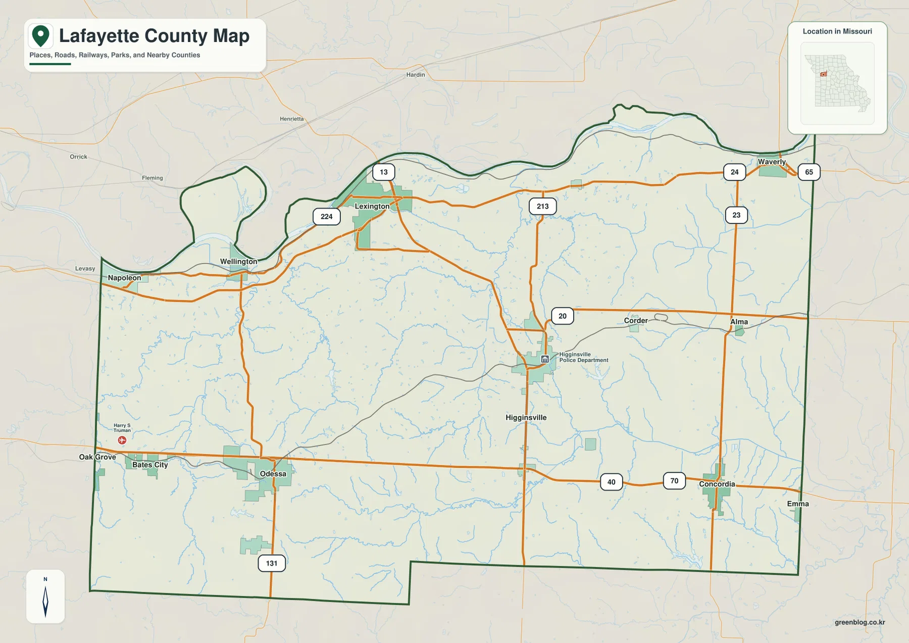
Lexington sits near the north-central edge of the county just south of the Missouri River. Route 13 runs south from the city toward Higginsville, Route 224 follows the river side west toward Wellington and Napoleon, and Route 24 continues east toward Waverly. This makes Lexington a useful junction between the river towns and the interior road network.
The official Lafayette County website identifies Lexington as the permanent county seat and lists the courthouse at 1001 Main Street. The county was organized in 1820 and renamed Lafayette in 1825 after the Marquis de Lafayette. On the modern map, Lexington remains both an administrative center and a strong geographic reference where the Missouri River lowland meets higher interior ground.
Higginsville and Odessa organize the interior road network
Higginsville lies slightly east of the county’s center near Routes 13 and 20. The supplied map labels the Higginsville Police Department within the developed area, and the city sits north of the I-70 and U.S. 40 corridor. Because Route 13 continues north toward Lexington, Higginsville provides an easy midpoint between the river side and the southern highway corridor.
Odessa occupies the southwest near I-70, U.S. 40, and Route 131. Bates City and Oak Grove lie just to the west, while roads extend north toward Wellington and Lexington. The landscape around Odessa is noticeably higher than the Missouri River edge, and the water map shows numerous short tributaries dividing the rolling farmland.
The city layer ranks six major communities
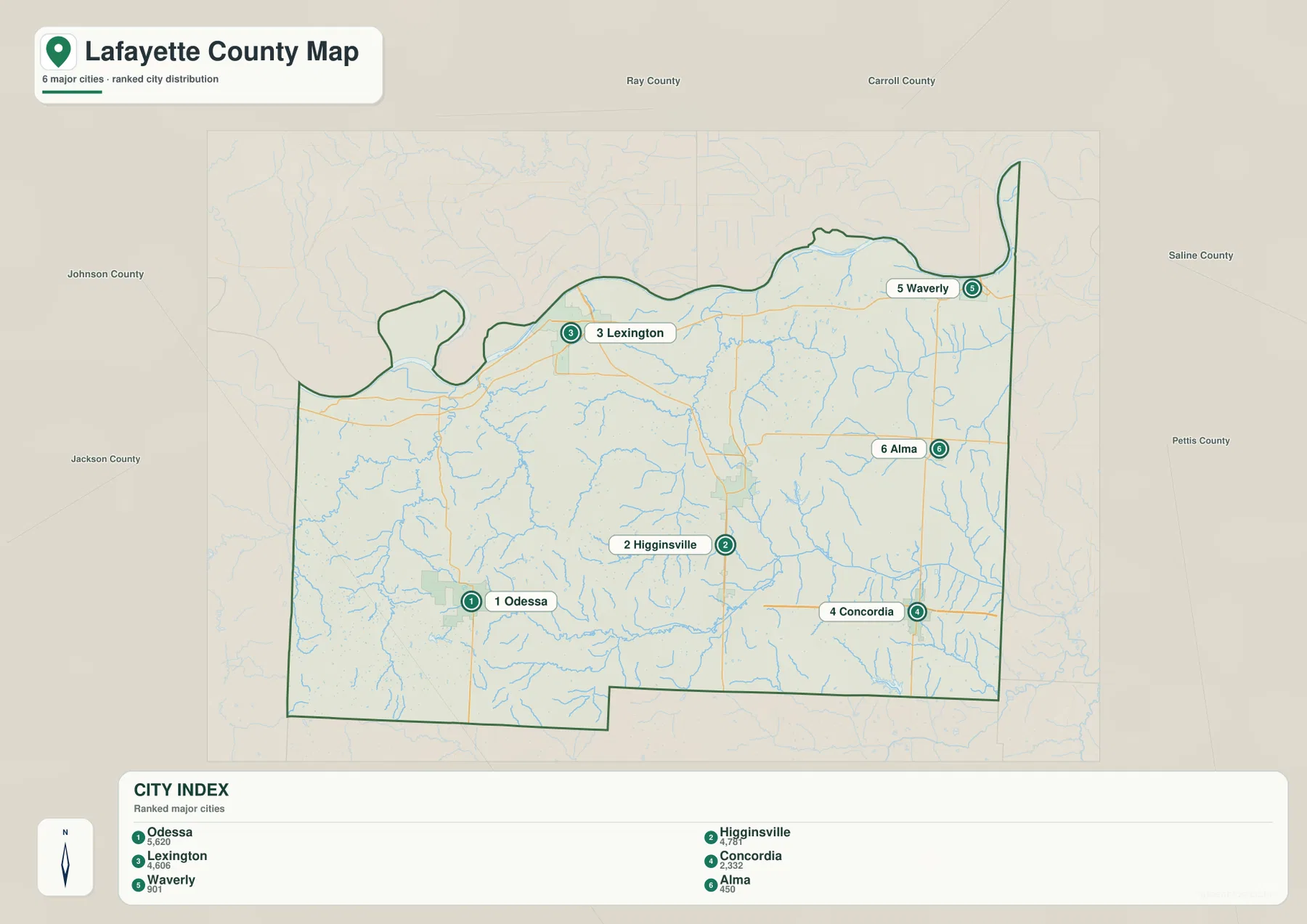
The ranked city map places Odessa first, Higginsville second, Lexington third, Concordia fourth, Waverly fifth, and Alma sixth. The CITY INDEX also displays a value for each community, but those numbers belong to the supplied map dataset and should not be presented as current official population estimates.
The distribution itself is more useful than the values. Odessa lies southwest, Higginsville near the center, Lexington on the north side near the river, Concordia southeast, Waverly in the northeastern river corridor, and Alma farther east. The numbered markers show rank rather than road mileage or travel time.
The Missouri River creates a broad low corridor from Napoleon to Waverly
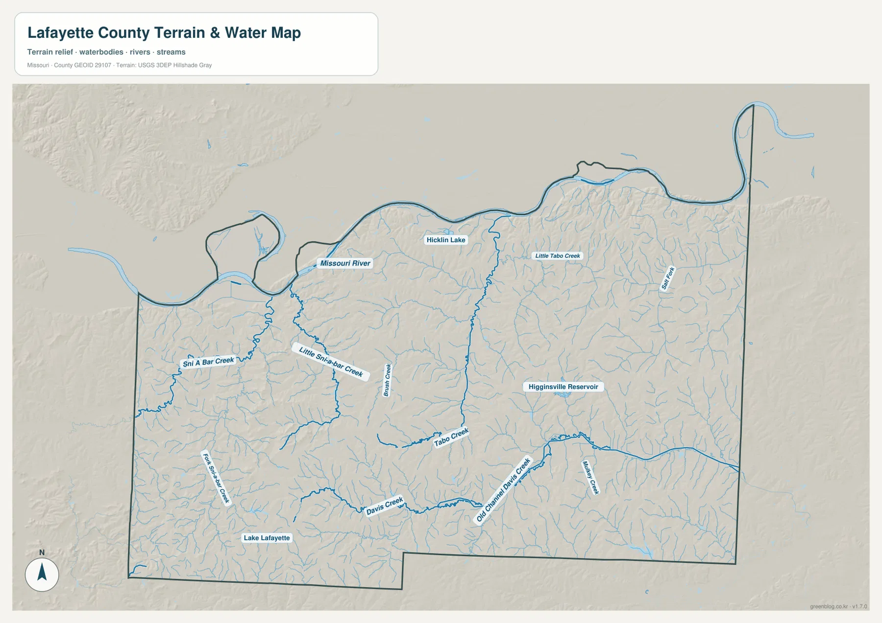
The Missouri River follows a series of large bends along the northern edge of Lafayette County. It passes the Napoleon and Wellington side in the west, continues north of Lexington, and reaches Waverly in the east. On both the terrain-and-water map and the elevation layer, this boundary forms the county’s broadest lowland.
The land rises quickly south of the river in several places, especially around Lexington and the nearby bluffs. Short tributaries cut through the slope between the uplands and the floodplain. The supplied water map is intended for general geographic reference and should not be used for current river stages, flood warnings, or legal floodplain decisions.
Sni-A-Bar Creek divides the western farm country
Sni-A-Bar Creek is one of the strongest named interior waterways on the western side of the county. Little Sni-a-Bar Creek joins the same broader landscape farther east, while Fork Sni A Bar Creek forms another southern drainage. Together, these streams divide the rural country north of Odessa and southwest of Lexington into repeated ridges and valleys.
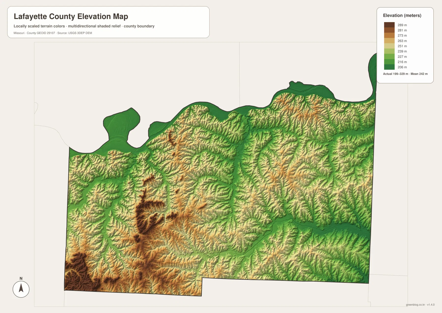
The elevation layer makes the pattern especially clear. The creek corridors remain green and low while the land between them rises into yellow and tan uplands. Unlike the broad Missouri River bottom, these are long, narrow valleys, and they explain much of the rolling character of western Lafayette County.
Tabo Creek and Higginsville Reservoir mark the central drainage
Tabo Creek crosses the central part of Lafayette County and provides a useful water reference between the western Sni-A-Bar system and the eastern creeks. Brush Creek descends nearby, and Higginsville Reservoir is labeled east and southeast of the city. Little Tabo Creek appears farther north in the central interior.
Around Higginsville, many of the most visible terrain changes occur outside the developed area. Small tributaries create green channels on the elevation map, while the ridges between them remain higher. The result is rolling agricultural land rather than a completely flat plain.
Davis Creek and Muddy Creek organize the southern and eastern side
Davis Creek runs across much of the southern interior, and Old Channel Davis Creek is labeled nearby in the east-central section. Muddy Creek forms another major drainage farther east around the Concordia and Alma side. Lake Lafayette is a small but useful landmark in the southwest.
Salt Fork appears in the northeastern interior south of Waverly, and Hicklin Lake is labeled closer to the Missouri River. These smaller waters do not dominate the county like the Missouri River, but they help match rural places between the road, terrain, and elevation maps.
Elevation ranges from about 199 to 329 meters
The elevation layer reports an actual mapped range of approximately 199 to 329 meters, with a mean near 242 meters. The Missouri River corridor forms the lowest continuous area along the northern edge. Higher terrain is much more extensive in the southwest and south-central interior, where tan and brown ridges rise above the creek valleys.
Sni-A-Bar Creek, Tabo Creek, Davis Creek, and Muddy Creek all cut narrow green corridors through the higher land. The contrast is particularly strong between the northern river bottom and the southwestern uplands around the Odessa side. This map is useful for county-scale terrain comparison but should not be treated as survey-grade or engineering-grade elevation data.
Battle of Lexington connects the river landscape with Civil War history
Lexington is home to Battle of Lexington State Historic Site, managed by Missouri State Parks. The site preserves the Oliver Anderson House, battlefield features, and a visitor center related to the three-day Civil War battle fought in September 1861. Missouri State Parks explains that control of the Missouri River was strategically important, making Lexington a significant military point.
That historical role makes sense on the county map. Lexington sits immediately above the Missouri River corridor and is connected inland by Route 13 and along the river by Routes 24 and 224. The historic site therefore adds useful context to the relationship between the river, transportation, and settlement. Current tours and operating hours should be checked on the Missouri State Parks page before visiting.
Lexington remains the county’s administrative center
Lafayette County’s official website lists the courthouse at 1001 Main Street in Lexington and provides access to the County Commission, County Clerk, Assessor, Collector, Recorder, and other offices. That confirms the city as both a geographic reference and the county’s current administrative center.
University of Missouri Extension also maintains a Lafayette County page with agriculture, business, health, 4-H, and community resources. Those services are especially relevant in a county with extensive farmland and many small communities. Office details and current programs should be checked directly on the official pages.
Choosing the right downloadable map
Use the general county map for Lexington, Higginsville, Odessa, the river towns, and the main road network. The ranked city layer is best for comparing Odessa, Higginsville, Lexington, Concordia, Waverly, and Alma. The terrain-and-water map is useful for the Missouri River, Sni-A-Bar Creek, Tabo Creek, Davis Creek, and reservoirs, while the elevation layer makes the difference between the low river edge and the higher southern uplands much clearer.
The download ZIP contains high-resolution JPG versions of the same map themes shown on the page. They are useful for enlarging labels, printing a reference sheet, or comparing layers side by side. The files are intended for general geographic reference and do not replace live navigation, flood warnings, legal boundary surveys, or professional elevation measurements.
Frequently Asked Questions
What are the best places to use as reference points in Lafayette County?
Lexington is the best reference for the Missouri River and county government, Higginsville works well for the central interior, and Odessa is a useful anchor for the southwestern I-70 corridor. Together they make the other towns easy to place.
Are the values on the city map current population counts?
They should not be treated as current official population estimates. The CITY INDEX values beside Odessa, Higginsville, Lexington, Concordia, Waverly, and Alma belong to the supplied map dataset, while the numbered markers show rank.
Where is the lowest terrain in Lafayette County?
The supplied elevation map shows the Missouri River corridor along the northern boundary as the broadest low area. Major creek valleys are also lower, while much of the southwest and south-central county rises into higher rolling uplands.
Map File Information
Download the map files associated with this page for reference, printing, and compatible visual projects.
- Included Files: Use only the versions confirmed in the article and supplied images
- File Type: Use the confirmed download contents
- Intended Use: Printing, education, presentations, and map-based projects
Related Maps
Sources and references
- Lafayette County, Missouri – Official Website – Lexington courthouse, county history, and local government
- Missouri State Parks – Battle of Lexington State Historic Site – Civil War battlefield and Missouri River history in Lexington
- University of Missouri Extension – Lafayette County – agriculture, 4-H, and community resources
- U.S. Census Bureau TIGER/Line Shapefiles – county boundary and road data
- USGS National Hydrography – rivers, streams, and water features
- USGS 3D Elevation Program – elevation data
Green Map creates custom-edited map images using open geographic data sources such as geoBoundaries, Natural Earth, OpenStreetMap, and government open data. These maps are edited visual materials, not raw data files, and are provided for education, documents, presentations, and graphic reference.