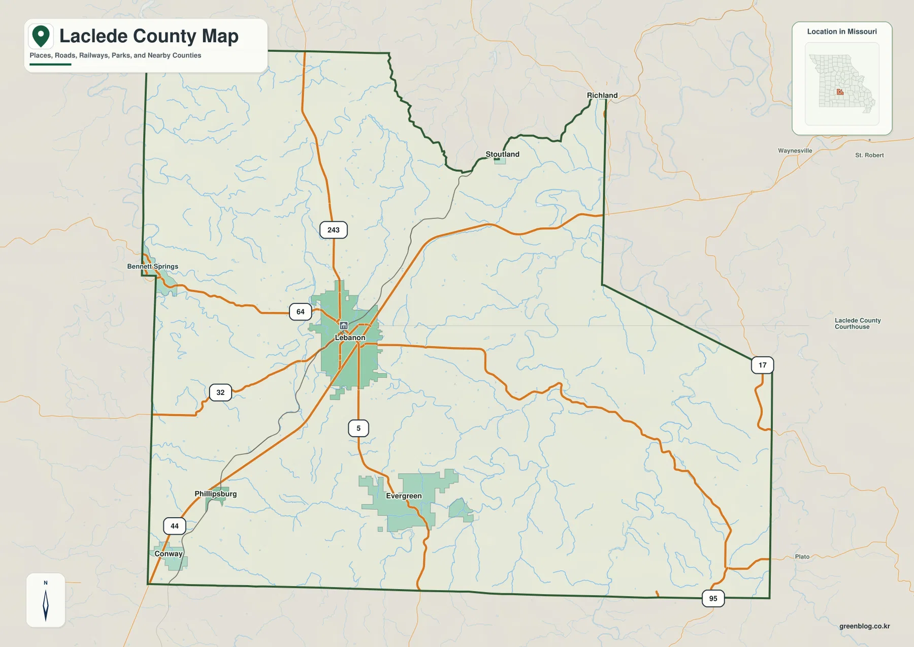
Laclede County sits in the central-southern Missouri Ozarks, with Lebanon as the dominant city and smaller communities such as Conway, Phillipsburg, Evergreen, Stoutland, and Richland spread across a deeply dissected landscape. The Niangua River reaches the northwest, while the Gasconade River and Osage Fork of the Gasconade cut long valleys through the eastern and southern parts of the county. Routes 5, 32, 64, 17, 95, and 243 provide the main road references, and the elevation layer ranges from about 228 to 446 meters. High-resolution JPG versions of the map themes can be downloaded together in the ZIP for printing or offline use. High-resolution map files are available for download in the section below.
A useful way to read Laclede County is to start at Lebanon and compare the southwest with the east. Conway and Phillipsburg lie toward the southwest, Evergreen is south of Lebanon, and Stoutland and Richland sit near the northeastern side. The road map looks relatively simple, but the water and elevation layers reveal a much more intricate Ozark landscape of long ridges, narrow tributaries, and deep river valleys.
Table of Contents
Lebanon is the county’s main road and administrative reference
Lebanon is the largest mapped urban area and lies slightly west of the county’s center. Route 5 runs north-south through the city, while Routes 32 and 64 provide strong east-west references. Route 243 extends north, Route 17 appears along the eastern side, and Route 95 helps orient the southeastern county. The Laclede County Courthouse is also labeled in Lebanon.
The official Laclede County government website identifies Lebanon as the county seat and lists the Government Center at 200 North Adams Avenue. The county also identifies Lebanon as its largest municipality, with Conway, Phillipsburg, Stoutland, Richland, and Evergreen among the other incorporated places. That makes Lebanon the natural anchor for comparing every other map layer.
Conway, Phillipsburg, and Evergreen organize the southern side
Conway lies near the southwestern corner of the county, close to the I-44 corridor. Phillipsburg is northeast of Conway and southwest of Lebanon, while Evergreen lies south of Lebanon near Route 5. These communities provide clear reference points for the higher terrain that dominates much of the southern and southwestern county.
Stoutland and Richland appear near the northeastern side. Their smaller developed areas sit closer to the deeply incised Gasconade drainage and Bear Creek country. Moving from the general road map to the terrain layer makes the contrast clear: the southwest is high and strongly ridged, while the east is cut by lower, winding river valleys.
The city layer uses Lebanon as a straight-line distance hub
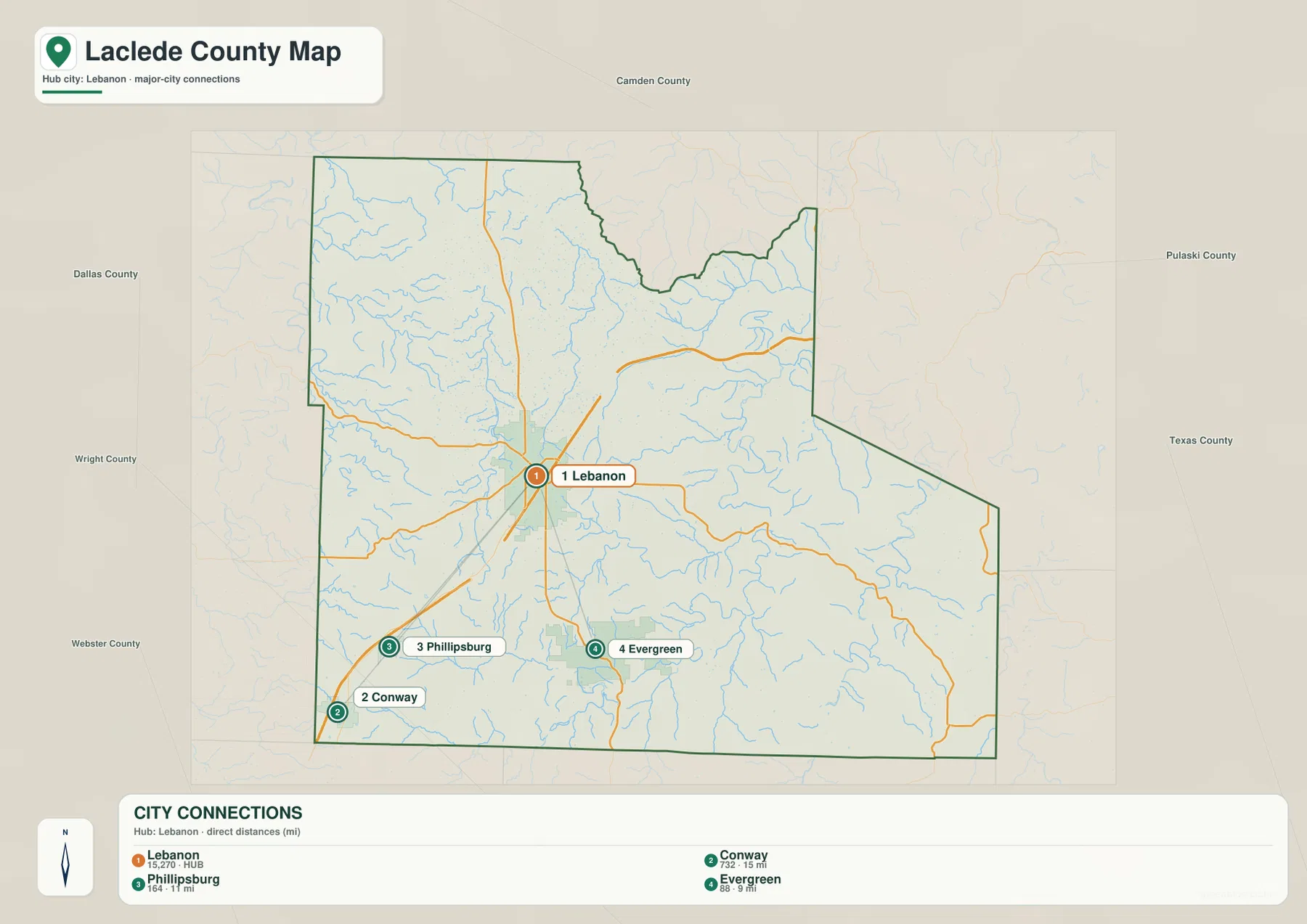
The city map is a connector-distance map rather than a simple ranked distribution. Lebanon is labeled as the HUB, with direct-distance links of about 15 miles to Conway, 11 miles to Phillipsburg, and 9 miles to Evergreen. Those measurements are straight-line distances between map points, not driving mileage.
Road travel can be longer because routes curve around Ozark ridges and stream valleys. The connector view is best used for direction and approximate separation: Conway lies southwest of Lebanon, Phillipsburg is also southwest but closer, and Evergreen is almost directly south. Numeric values shown under the place names belong to the supplied city dataset and should not automatically be treated as current official population figures.
Niangua River and Bennett Spring shape the northwestern corner
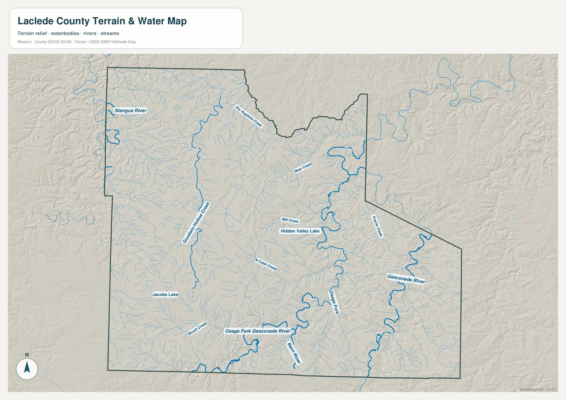
Niangua River is the main river feature in northwestern Laclede County. Its valley cuts into the Ozark uplands and is joined by many small tributaries. Bennett Springs is labeled near the western edge of the general map, providing an easy geographic link between the river system and one of the county’s best-known recreation areas.
Missouri State Parks places Bennett Spring State Park in Dallas and Laclede counties and reports that Bennett Spring releases more than 100 million gallons of clear water per day into the Niangua River. The park is well known for trout fishing, camping, cabins, and hiking. On the elevation map, the river side is distinctly lower than the broad high ground farther south and east.
Dry Auglaize Creek and Goodwin Hollow divide the north-central uplands
Dry Auglaize Creek runs through the north-central part of the county, while Goodwin Hollow Creek forms another long drainage farther west. These streams cut through the high land between the Niangua and Gasconade systems and create closely spaced valleys that are easy to miss on the road map.
Missouri Geological Survey material for Laclede County describes about 146 square miles of the north-central county as draining through Grand Glaize Creek tributaries, specifically Goodwin Hollow and Dry Auglaize Creek. That watershed distinction explains why the north-central streams do not simply follow the same direction as the Gasconade drainage farther east.
Gasconade River creates the deepest eastern corridor
Gasconade River is the dominant watercourse on the eastern side of Laclede County. It winds through a broad lower valley and is joined by Bear Creek, Palmer Creek, and numerous smaller tributaries. The elevation layer shows the river as a strong green corridor against much higher surrounding ridges.
Missouri Department of Conservation describes the Gasconade as a 271-mile river that passes through Laclede County and several other Ozark counties before reaching the Missouri River. The map shows the same pattern locally: the farther east the landscape approaches the Gasconade, the more strongly the terrain drops into a deep and winding valley. The water layer is a geographic reference rather than a live river-stage or flood-warning product.
Osage Fork of the Gasconade is the major southern drainage
The Osage Fork of the Gasconade River crosses the southern and south-central county before joining the Gasconade system to the east. North Cobb Creek and Brush Creek enter from the western side, while Mill Creek and Hidden Valley Lake provide additional references farther north. This is one of the strongest valley systems on the terrain map.
Missouri Geological Survey material identifies the Osage Fork as draining a large share of southern and east-central Laclede County. Missouri Department of Conservation also manages a special section of the river from the Skyline Drive bridge near Orla to the Gasconade River. Together, the Osage Fork and Gasconade define much of the county’s eastern and southern relief.
Elevation ranges from about 228 to 446 meters
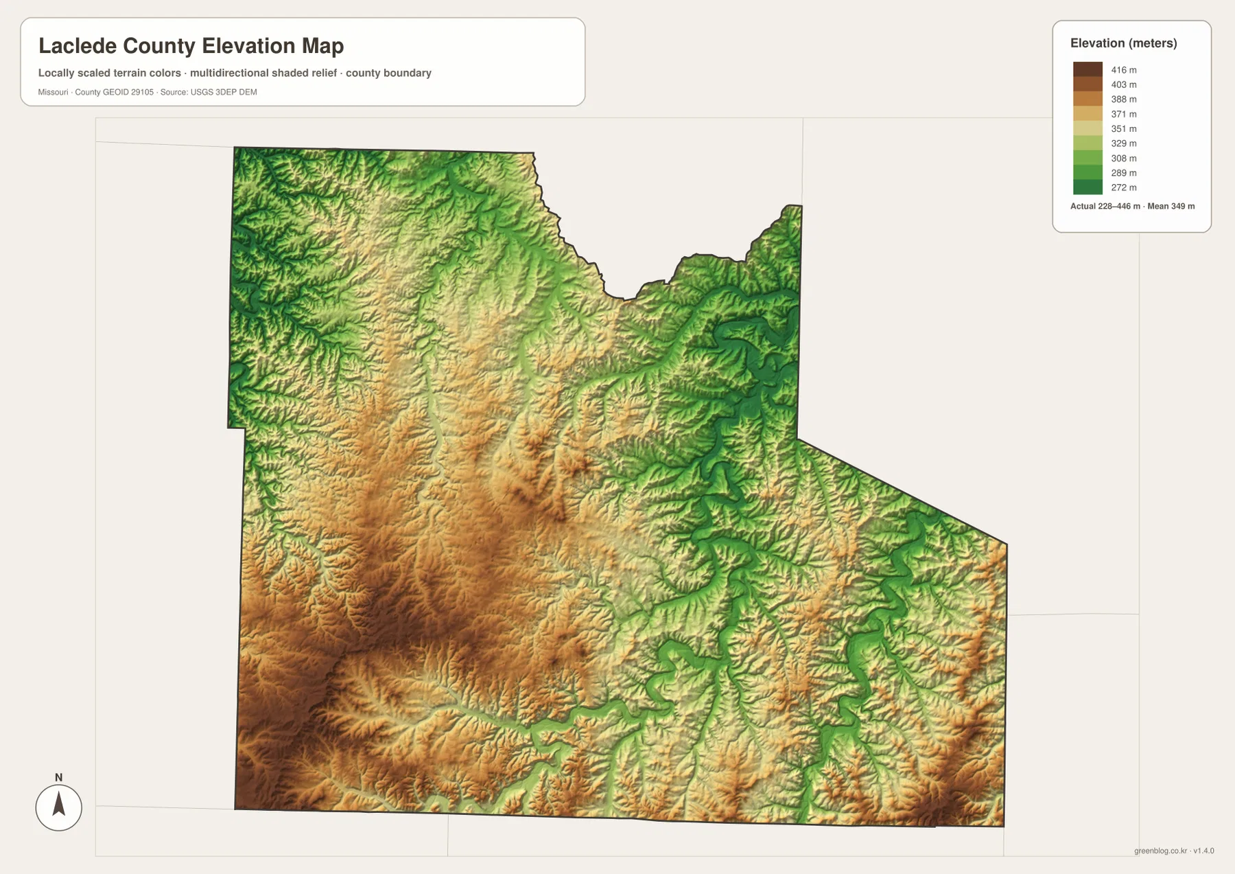
The elevation map reports an actual mapped range of approximately 228 to 446 meters, with a mean near 349 meters. The southwest and south-central parts of Laclede County contain extensive tan and brown high ground. Niangua River, Gasconade River, and the Osage Fork form much lower green valleys through those uplands.
Lebanon sits within rolling high country rather than a broad flat plain. Eastward, the Gasconade valley becomes deeper and more pronounced, while the northwestern Niangua corridor also drops sharply below surrounding ridges. The Osage Fork creates another long low route across the south. This map is useful for county-scale terrain comparison but should not be used as survey-grade or engineering-grade elevation data.
Lebanon’s Route 66 history matches its central transportation role
Lebanon has long been a transportation crossroads in southwest Missouri. The City of Lebanon’s official history describes an early trail that later became the Civil War-era Wire Road and explains that Route 66 followed a similar path through the area beginning in the late 1920s. Modern I-44 follows much of the same general east-west corridor.
That history fits the present map. Lebanon remains the place where several major roads converge, and the routes toward Conway, Phillipsburg, and the eastern county continue to radiate from the city. The map is not a dedicated Route 66 travel guide, so anyone planning a historic-road trip should still use current city and highway information for the exact drivable alignment.
Gasconade River access sites connect the map with public use
Missouri Department of Conservation’s Anna M. Adams Access provides a small public access point on the Gasconade River east of Lebanon. MDC lists a concrete boat ramp, parking, and bank-fishing opportunities, making it a practical example of the river corridor shown on the terrain map.
Hazelgreen Access is another Gasconade River site east of Lebanon and lies less than a mile downstream from the mouth of the Osage Fork. That location makes the confluence especially easy to connect with the county’s water map. Current road access and site regulations can change, so visitors should check the MDC pages before traveling.
Choosing the right downloadable map
Use the general county map for Lebanon, surrounding towns, and major roads. The city connections map is best for comparing the straight-line direction and separation of Conway, Phillipsburg, and Evergreen from Lebanon. The terrain-and-water layer is useful for the Niangua, Gasconade, Osage Fork, and their tributaries, while the elevation map shows the contrast between high southwestern uplands and deep eastern river valleys.
The download ZIP contains high-resolution JPG versions of the same map themes shown on the page. They are useful for enlarging labels, printing a reference sheet, or comparing layers side by side. The files are intended for general geographic reference and do not replace live navigation, flood warnings, legal boundary surveys, or professional elevation measurements.
Frequently Asked Questions
What is the easiest place to use as a reference in Laclede County?
Lebanon is the clearest starting point. Routes 5, 32, and 64 meet in the area, county government is centered there, and the city provides an easy reference for Conway, Phillipsburg, Evergreen, Stoutland, and Richland.
Are the 9, 11, and 15 mile labels on the city map driving distances?
No. They are direct straight-line distances from Lebanon to Evergreen, Phillipsburg, and Conway. Actual road mileage can be longer because routes curve through Ozark terrain.
Where is the strongest elevation contrast in Laclede County?
The supplied elevation map shows high ground across much of the southwest and south-central county, while the Gasconade River, Osage Fork, and Niangua River occupy much lower valleys. The mapped range is about 228 to 446 meters.
Map File Information
Download the map files associated with this page for reference, printing, and compatible visual projects.
- Included Files: Use only the versions confirmed in the article and supplied images
- File Type: Use the confirmed download contents
- Intended Use: Printing, education, presentations, and map-based projects
Related Maps
Sources and references
- Laclede County Missouri Government Center – county government and local information in Lebanon
- Missouri State Parks – Bennett Spring State Park – Bennett Spring and Niangua River context
- Missouri Department of Conservation – Gasconade River – official Gasconade watershed information
- City of Lebanon – History of Lebanon – Route 66 and Lebanon transportation history
- U.S. Census Bureau TIGER/Line Shapefiles – county boundary and road data
- USGS 3D Elevation Program – elevation data
Green Map creates custom-edited map images using open geographic data sources such as geoBoundaries, Natural Earth, OpenStreetMap, and government open data. These maps are edited visual materials, not raw data files, and are provided for education, documents, presentations, and graphic reference.