Dade County sits in southwest Missouri where small towns, farm roads, stream valleys, and rolling uplands share the same compact county outline. This page uses Greenfield as the main reference point, then follows the map west to Lockwood, east to Dadeville, southeast to Everton, south to South Greenfield, and north toward Arcola. The on-page maps can be viewed directly, and high-resolution JPG versions are also available together in one downloadable ZIP for printing or offline reference.
The general county map shows a road network centered on Greenfield, while the water map reveals how deeply the Sac River and its tributaries cut into the northern and eastern parts of the county. The elevation layer adds another dimension: lower green valleys follow the rivers and creeks, while warmer colors mark higher ground across much of the south and southwest. Comparing the same places across these maps gives a clearer picture than any single layer can provide.
Table of Contents
Greenfield as the road-network reference point
Greenfield is the easiest place to begin reading the county map. Route 39 runs north and south through the central part of Dade County, placing Greenfield close to the middle of the mapped road network. Lockwood lies to the west near Route 97, while Dadeville sits well to the east near the Route 245 corridor. Route 215 crosses the northern portion, and U.S. 160 appears toward the east and southeast. These numbered routes make it easier to keep the scattered communities oriented.
South Greenfield appears just below Greenfield, so the two names are close together on the map even though they remain distinct places. Arcola is much farther north, and Everton is positioned in the southeastern part of the ranked-city map. The layout matters because Dade County does not read as one continuous built-up corridor. Its communities are separated by rural land, creeks, and rolling terrain, and the road map shows how the main routes connect those separate parts of the county.
Six ranked communities across the county
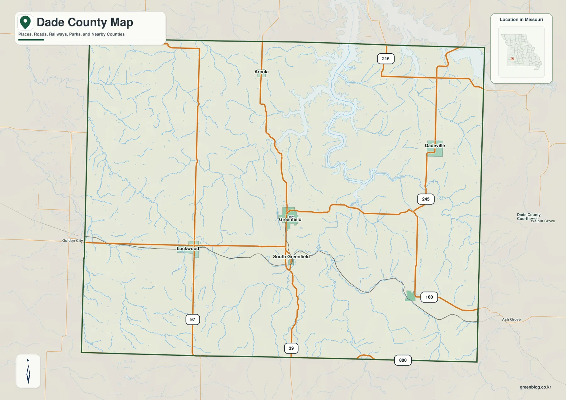
The city distribution map ranks Greenfield first, Lockwood second, Dadeville third, Everton fourth, South Greenfield fifth, and Arcola sixth. The numbers are ranking markers used to identify the six major communities on this map; they are not road distances, straight-line distances, or travel times. Greenfield occupies the central reference position, Lockwood anchors the west, and Dadeville provides an eastern counterpart. Everton, South Greenfield, and Arcola fill in the southern, central, and northern parts of the county.
This distribution view is especially helpful when moving between the city map and the general road map. Greenfield and South Greenfield line up near Route 39, while Lockwood is easier to find by following the western Route 97 corridor. Dadeville is located toward the eastern side of the county, away from the central Greenfield cluster. Arcola’s northern position and Everton’s southeastern location show how widely the county’s principal places are spread.
Sac River valleys in the north and east
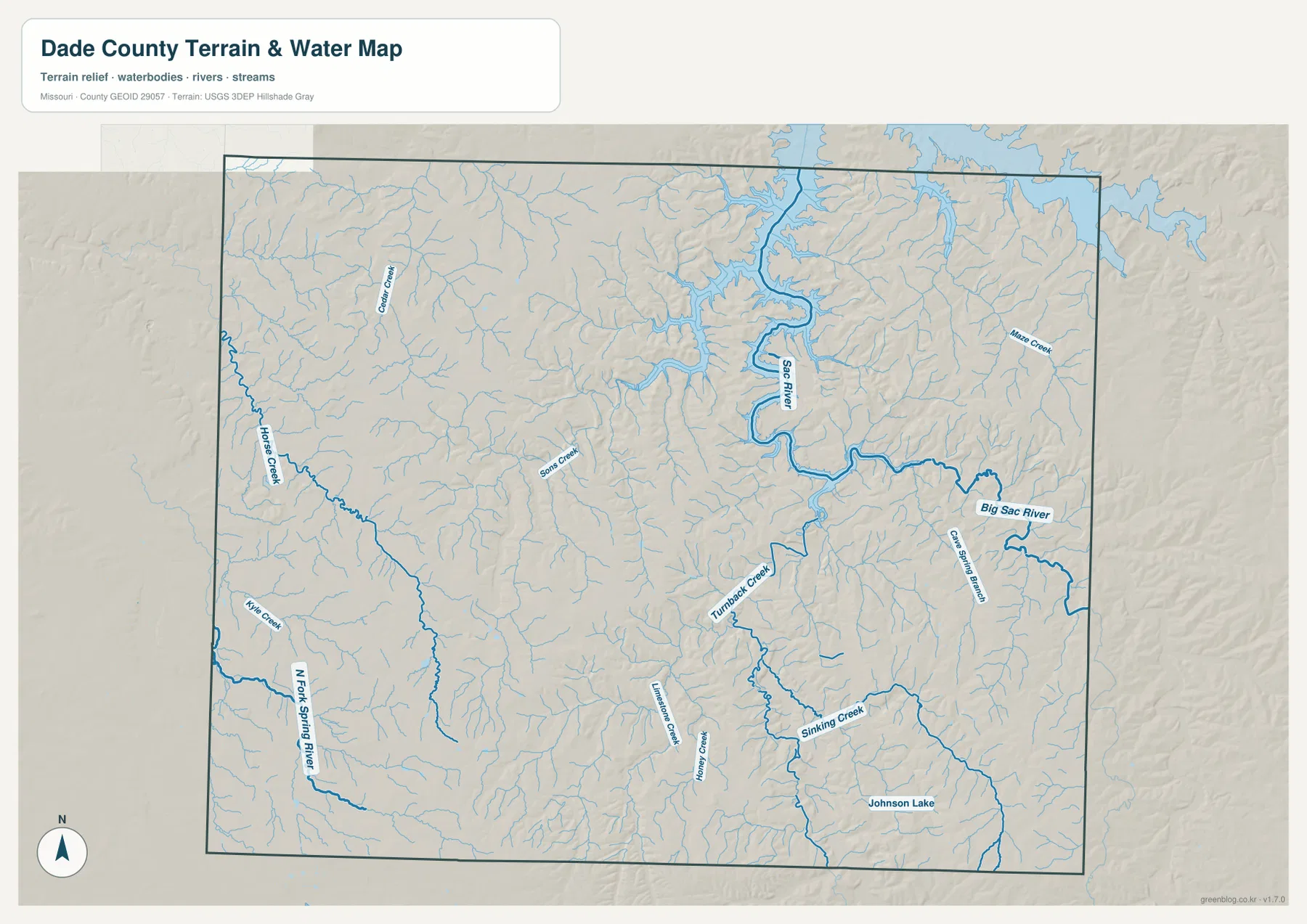
The water map is dominated by the Sac River, which winds through the north-central part of Dade County before continuing into a broader network of river valleys. Big Sac River is labeled farther east and southeast, where the stream corridor forms another strong feature on the map. Numerous smaller branches feed both river systems. Their density helps explain why the terrain layer contains so many narrow valleys and short ridges rather than a single flat surface.
Missouri Department of Conservation describes Dade County as part of the Sac River basin and identifies tributaries such as Turnback Creek, Sons Creek, Horse Creek, and other streams within the watershed. Several of those names are visible on the supplied map. That overlap makes the county map useful for connecting local labels to the larger watershed: the small creeks visible near Greenfield and the surrounding uplands eventually join the larger Sac River system.
Creeks and local water features beyond the main river
Horse Creek is one of the most prominent named streams on the western side of the county, while North Fork Spring River appears along the southwest. Greenfield Creek is labeled in the northwest, and Turnback Creek, Sons Creek, Limestone Creek, Honey Creek, and Sinking Creek add detail across the interior. Johnson Lake is also labeled in the southeast. These names show that Dade County’s water geography cannot be reduced to the Sac River alone.
The water map should be used as a geographic reference rather than a flood forecast, property survey, or navigation product. A creek’s mapped position helps explain nearby valleys, but it does not tell a reader whether a road is passable, whether a parcel is in a regulated floodplain, or whether a crossing is currently safe. For those questions, current agency information is required. Here, the value of the layer is in showing how streams fit into the county’s broader terrain.
Elevation from 264 to 387 meters
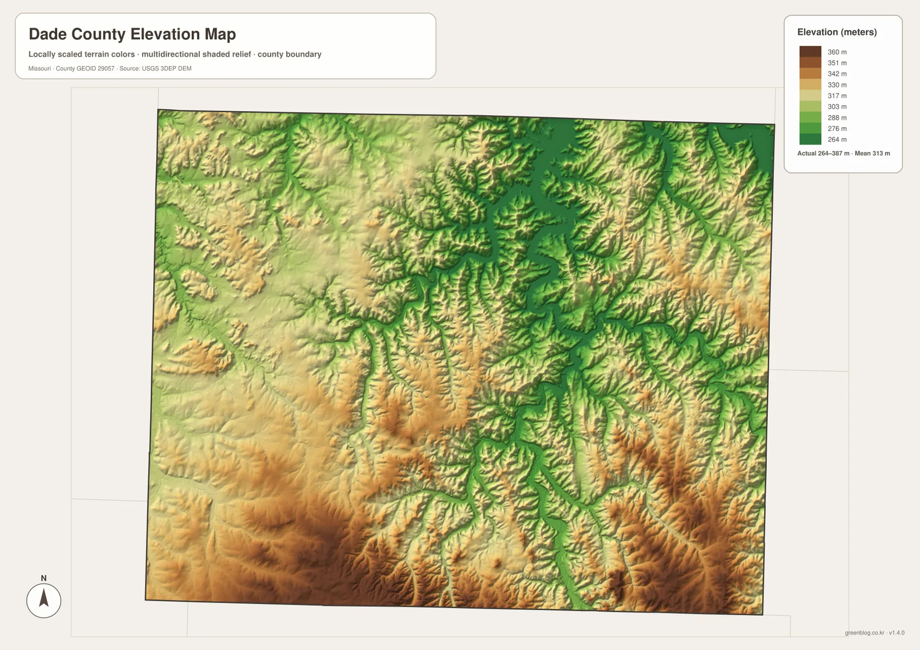
The elevation map shows an actual mapped range of about 264 to 387 meters, with a mean near 313 meters. Lower green tones follow the Sac River and many of the tributary valleys, especially through the north-central and eastern parts of the county. Higher tan and brown terrain becomes more extensive across the south and southwest. The total relief is large enough for the shaded map to reveal a strong contrast between valley floors and the surrounding uplands.
Greenfield sits within a landscape of alternating ridges and shallow valleys rather than at the foot of one dominant mountain ridge. Farther north, the terrain falls toward the Sac River corridor, while the southern half contains broader areas of higher ground. The pattern becomes particularly clear where narrow green drainage lines cut into warmer-colored uplands. This map is intended for county-scale comparison and should not be treated as survey-grade elevation for engineering or construction.
Greenfield and official county context
Dade County’s official government website places the county courthouse at 300 W. Water Street in Greenfield. The City of Greenfield’s official website also identifies Greenfield as the county seat and notes that the courthouse is located in the town’s historic square. Those local references match the map’s visual emphasis on Greenfield as the central named place and make it a practical starting point for readers who are unfamiliar with the county.
The local websites are useful for administrative and community information that a geographic map cannot provide. The maps on this page serve a different purpose: they show how Greenfield relates spatially to Lockwood, Dadeville, Everton, Arcola, the surrounding road network, and the nearby drainage system. Using the official sites together with the county maps gives readers both the local civic context and the physical layout.
Tracing one place across all four map themes
A simple way to use the set is to start with Greenfield on the general map. After locating Route 39 and the roads leaving town, switch to the water map and find the creeks and Sac River valleys around the same central area. Then open the elevation map to see which stream corridors sit below the neighboring ridges. Because every layer uses the same county boundary, the comparison can be made without learning a new coordinate system or map extent.
The same method works from Lockwood, Dadeville, or Everton. Lockwood can be compared with Horse Creek and the western uplands; Dadeville can be viewed against the eastern drainage network; and Everton helps anchor the southeastern part of the county. Arcola and South Greenfield add northern and southern reference points. Moving one familiar name through the four map themes turns separate images into a coherent view of roads, water, settlements, and relief.
Using the high-resolution map files
The downloadable ZIP contains high-resolution JPG versions of the general county map, the ranked city distribution map, the terrain-and-water map, and the elevation map. The larger files are more useful than the on-page WebP previews when readers need to enlarge labels, print a reference sheet, or place a map in a personal research document or classroom handout. Keeping all four files together also makes side-by-side comparison much easier.
These maps are static geographic references, not live navigation or emergency products. Road closures, construction, flood warnings, legal property boundaries, and other time-sensitive conditions require current official sources. The elevation layer is also a generalized county-scale surface rather than a substitute for field surveying. Used within those limits, the files provide a clear way to study Dade County’s communities, roads, streams, and changing terrain.
Frequently Asked Questions
What is the easiest place to use as a reference on the Dade County maps?
Greenfield is the clearest starting point because it is near the center of the county map, lies on Route 39, and is identified by local official sources as the county seat. From Greenfield, readers can orient themselves toward Lockwood in the west, Dadeville in the east, Everton in the southeast, Arcola to the north, and South Greenfield immediately to the south.
Do the numbers on the city map represent distance?
No. The numbers rank six major communities: Greenfield, Lockwood, Dadeville, Everton, South Greenfield, and Arcola. They do not represent driving distance, straight-line distance, or travel time. Use the actual map positions and road layer when comparing where the communities sit.
What elevation range is shown for Dade County?
The supplied elevation map shows approximately 264 to 387 meters, with a mean near 313 meters. Lower terrain follows the Sac River and many creek valleys, while higher ground is more extensive across the south and southwest. The values are suitable for broad county-scale comparison, not precision surveying or engineering work.
Map File Information
Download the map files associated with this page for reference, printing, and compatible visual projects.
- Included Files: Use only the versions confirmed in the article and supplied images
- File Type: Use the confirmed download contents
- Intended Use: Printing, education, presentations, and map-based projects
Related Maps
Sources and references
- Dade County, Missouri official website – county government and courthouse information in Greenfield
- City of Greenfield official website – local information and Greenfield county-seat context
- Missouri Department of Conservation – Sac River – watershed information including Dade County and named tributaries
- U.S. Census Bureau TIGER/Line Shapefiles – county boundaries and road data
- USGS National Hydrography – rivers, streams, and water features
- USGS 3D Elevation Program – elevation data
Green Map creates custom-edited map images using open geographic data sources such as geoBoundaries, Natural Earth, OpenStreetMap, and government open data. These maps are edited visual materials, not raw data files, and are provided for education, documents, presentations, and graphic reference.