Clark County occupies Missouri’s far northeastern corner, where the landscape changes from rolling uplands around Kahoka and the western half of the county to broad low ground near the Mississippi River. U.S. 136 crosses the county from west to east, passing through Kahoka before continuing toward Wayland and Alexandria, while U.S. 61 forms another major north-south reference in the east. The four maps on this page cover roads and places, ranked city distribution, terrain and water, and elevation. High-resolution JPG originals of all four are available together in the download box below.
Kahoka is the easiest starting point for reading the county. It sits near the middle of Clark County where U.S. 136 meets Missouri Route 1. Follow U.S. 136 west and the map leads toward Medill and Luray; follow it east and Wayland appears before the road reaches the Alexandria side of the county. Revere lies to the north, Wyaconda near the western boundary, and St. Francisville close to the northeastern edge. Once those place names are familiar, the Fox River and Wyaconda River valleys explain much of the remaining road and terrain pattern.
The official Clark County site describes a county organized in 1836 and named for William Clark. Its local history also emphasizes broad prairie land, broken hills along larger streams, and rich bottomlands near the Des Moines and Fox rivers. Those descriptions match the supplied maps well: western and central Clark County show frequent ridges and branching valleys, while the eastern edge becomes distinctly lower and flatter as it approaches the Des Moines and Mississippi river corridors. This article therefore focuses on the geographic relationships visible in the maps rather than trying to reproduce a full county history.
Table of Contents
U.S. 136 ties Kahoka to Wayland and the Mississippi side of the county
U.S. 136 is the clearest east-west line on the general county map. It enters from the Luray side, passes Medill, crosses Kahoka, then continues through the eastern half toward Wayland and Alexandria. Missouri Route 1 intersects it at Kahoka and provides a strong north-south reference through the center. Near Wayland, U.S. 61 and Route 27 add a second group of numbered highways, so the eastern part of Clark County has a more concentrated highway pattern than the western side.
Kahoka works as a geographic anchor because the road pattern is simple enough to remember. U.S. 136 establishes east and west, while Route 1 makes north and south immediately clear. Route 81 appears farther south, and smaller roads connect toward Revere and rural communities to the north. Instead of a dense metropolitan street grid, the county is organized around a small set of numbered routes crossing wide areas of farmland and stream-cut terrain. That makes the general map especially effective when printed or viewed at a larger scale.
The western side contains Wyaconda, Luray, and Medill at fairly wide intervals. Roads there cross more rolling ground and meet a dense network of small tributary valleys. Moving east from Kahoka, Wayland becomes a stronger road junction and Alexandria sits near the narrow southeastern extension of the county, close to the Mississippi River lowlands. St. Francisville occupies a different border setting to the northeast, near the Des Moines River side of the county.
State and county boundaries also explain the unusual shape. Scotland County lies to the west, with Knox and Lewis counties along the southwestern and southern sides. Iowa is immediately north. The Des Moines River helps form the northeastern boundary, and the Mississippi River separates Clark County from Illinois on the east. Clark County is therefore best understood as a three-state corner landscape influenced by two major rivers rather than as a simple rectangular inland county.
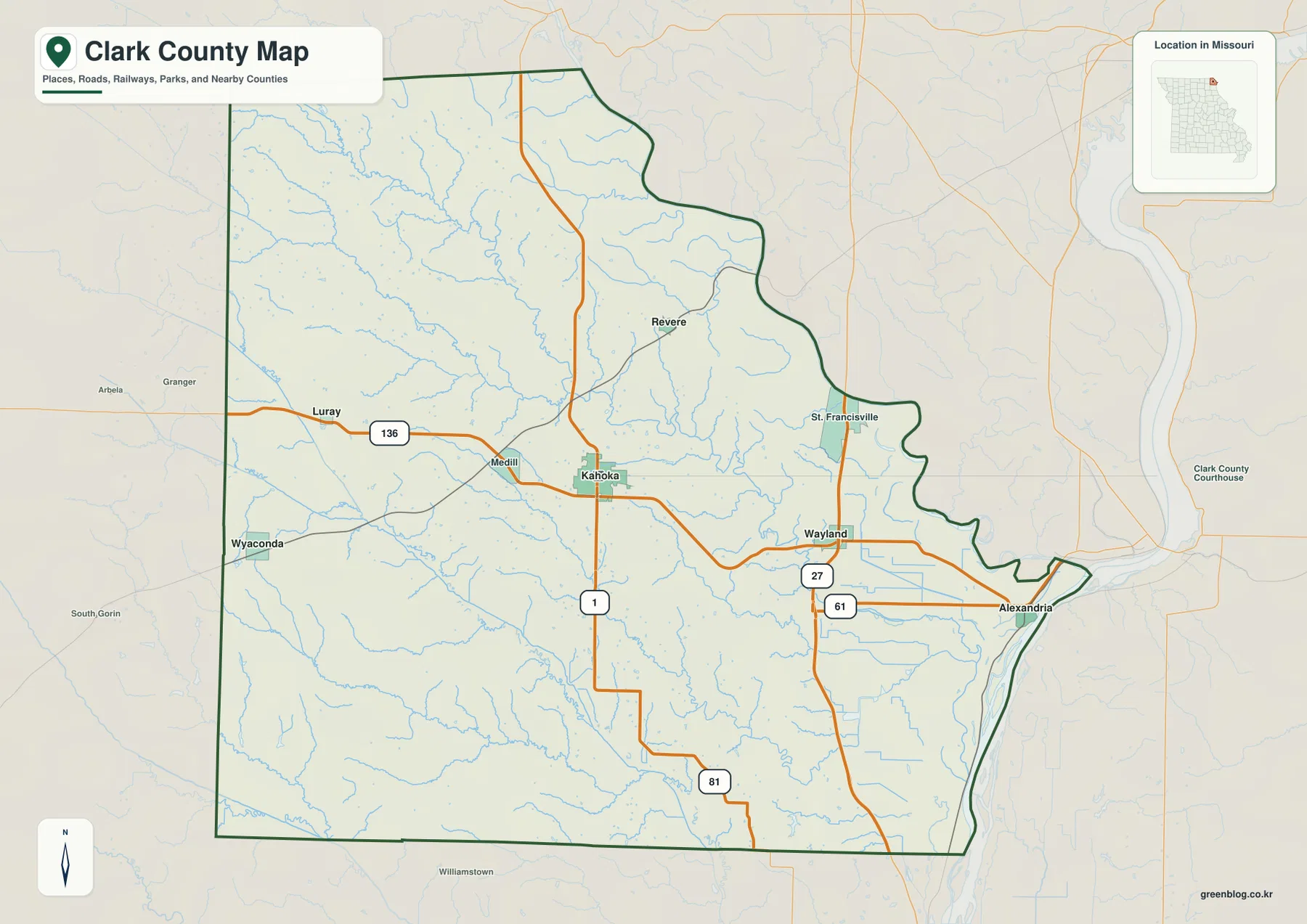
Use the general map when roads, communities, streams, and the county outline need to appear together. A useful method is to trace U.S. 136 from Kahoka to Alexandria, then switch to the terrain-and-water map and see where the Fox River and smaller tributaries cross the same part of the county. The image is not a live navigation product, however, and it does not show current closures, construction, or traffic conditions. Current travel decisions should be checked against up-to-date road information.
Six ranked cities show a dispersed settlement pattern
The ranked city map removes most road detail and highlights six communities: Kahoka first, Wayland second, Wyaconda third, Luray fourth, Alexandria fifth, and Revere sixth. The ranking is useful, but the spatial pattern matters more for understanding Clark County. Kahoka sits near the center, Wayland occupies the eastern interior, Wyaconda and Luray are on the west side, Alexandria is close to the southeastern river edge, and Revere is distinctly farther north.
Kahoka and Wayland are easy to connect mentally because both lie along the U.S. 136 corridor. Wyaconda and Alexandria illustrate the opposite edges of the county: Wyaconda is near the western boundary in more rolling terrain, while Alexandria lies beside the lower eastern side close to the Mississippi River. Revere occupies the northern uplands. St. Francisville appears on the detailed county map but not among the six ranked cities, a reminder that the city index is a selective summary rather than a complete municipal inventory.
Placing the city distribution beside the water and elevation maps adds physical context. North of Kahoka, the Fox River and its tributaries create a broad set of valleys. South and west, the Wyaconda River system cuts another group of low corridors. Wayland and Alexandria are closer to the broad eastern lowland where elevation colors shift toward green. The communities therefore sit in different terrain settings even though they belong to the same predominantly rural county.
This city graphic does not measure straight-line distance, driving distance, or travel time. It also does not show the legal extent of municipal boundaries. Its strength is clarity: for a classroom handout, presentation, or quick county overview, it immediately shows where the principal communities are located. When a road number or smaller place is important, the general county map is the better companion.
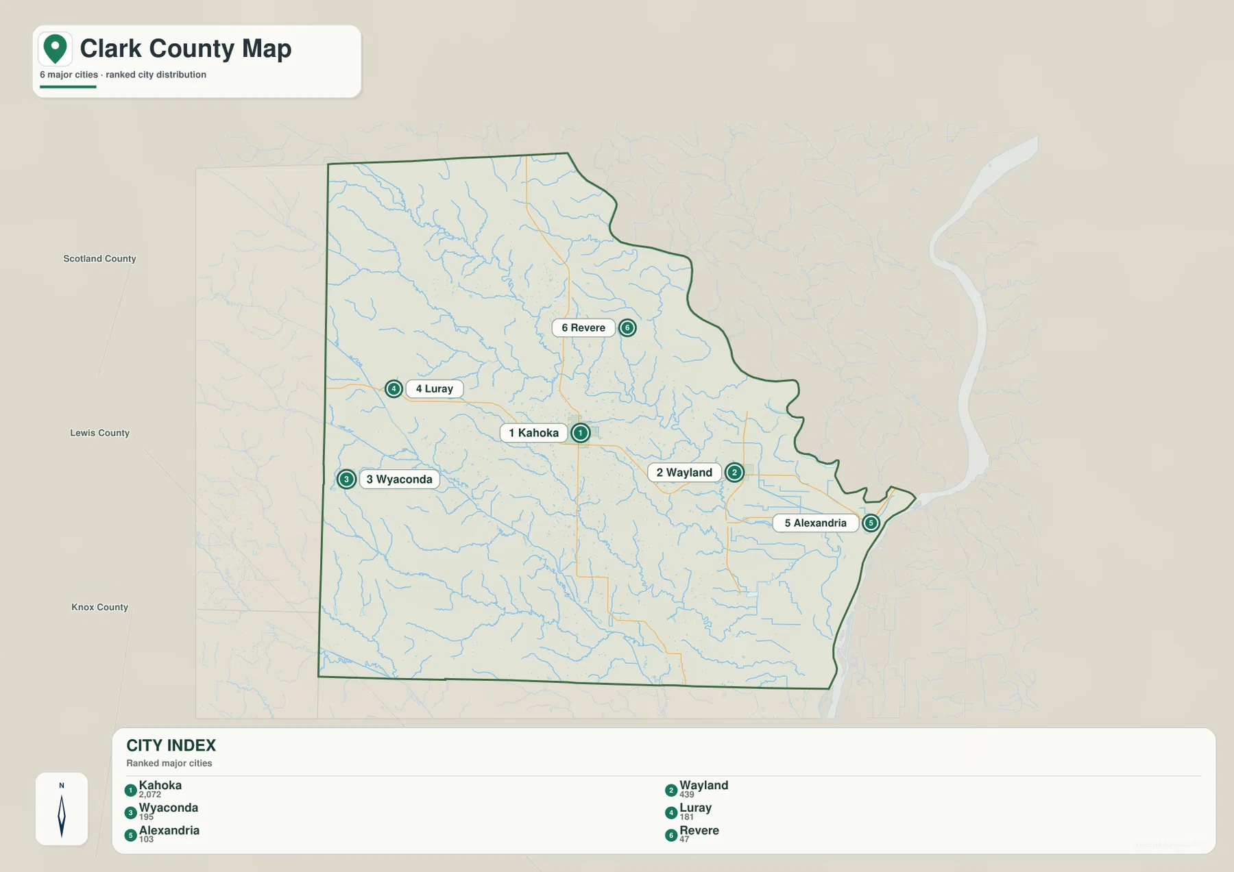
A simple way to remember the pattern is to use U.S. 136 as the horizontal reference: Luray sits west of Kahoka, Wayland east of it, and Alexandria still farther toward the river. Add Wyaconda at the far western side and Revere to the north. That mental framework makes the drainage maps easier to read because each major river valley can then be related back to a familiar town or road corridor.
Fox River and the Wyaconda system divide the county into distinct drainage areas
The terrain-and-water map makes the Fox River the dominant feature of northern and central Clark County. It enters from the northwest and bends southeast through a long valley. Little Fox River joins the system from the west, while N Elm Creek and numerous smaller tributaries feed the same corridor. The broad Fox valley lies north of Kahoka and southwest of Revere, and the surrounding shaded relief shows that many of the short streams occupy narrow cuts between rolling uplands.
Farther south, Wyaconda River and Little Wyaconda River create a second large drainage pattern. Their valleys extend from the western side toward the east and southeast, accompanied by the Old Channel Wyaconda River and tributaries such as Honey Creek and Bear Creek. Separating the Fox drainage from the Wyaconda drainage is more useful than trying to memorize every stream label at once. The two systems explain why the county contains several long low corridors rather than one uniform slope toward the Mississippi.
The eastern third contains shorter waterways such as Sisson Creek and Weaver Branch flowing toward broader low ground. Stout Pond is also labeled on the map. These eastern channels cross smoother terrain than many of the tributaries in the northwest, where branching valleys produce a tighter pattern. Shaded relief helps distinguish those settings: a blue line in a steeply incised western valley looks very different from a channel crossing the flatter eastern river plain.
Clark County’s official history names the Des Moines, Little Fox, Wyaconda, Little Wyaconda, Honey Creek, and other streams as important parts of the drainage network. The supplied terrain-and-water map supports that broader description, with the Fox and Wyaconda systems especially prominent and the eastern lowlands opening toward the major border rivers. Reading direction and valley shape is more informative than treating the hydrography as a list of names.
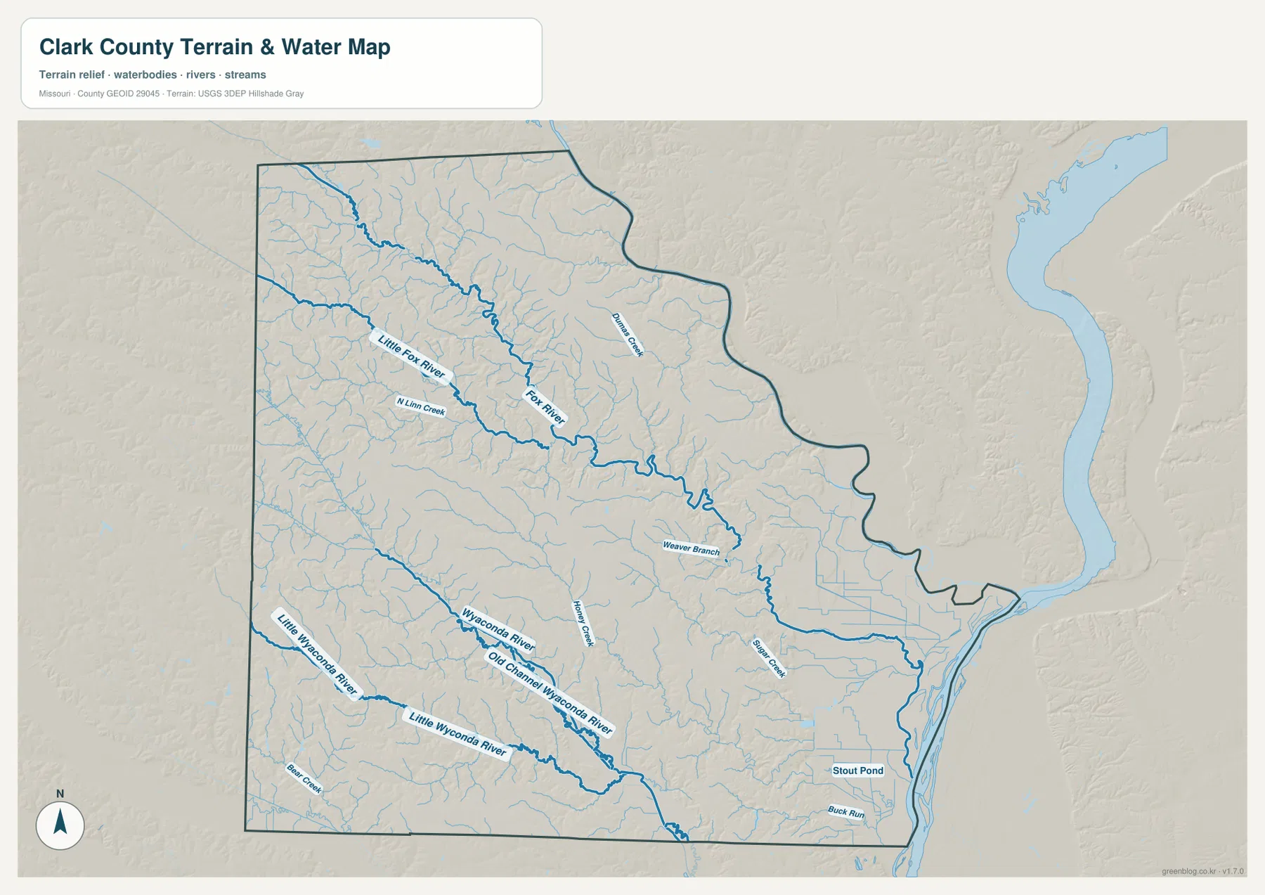
This is a geographic reference map, not a current flood or stream-stage product. A river or low area drawn on the map does not by itself identify an active floodplain, safe crossing, levee condition, or property-level risk. For safety, insurance, farming drainage, or property decisions, use current FEMA flood information, USGS stream data, and local government guidance instead of inferring conditions from the map colors.
The Des Moines and Mississippi rivers create a low border landscape in the east
Clark County’s eastern edge has a very different shape from its western boundary. The northeastern outline bends with the Des Moines River, while the far east meets the Mississippi River opposite Illinois. Alexandria lies close to the lower southeastern edge, and St. Francisville is positioned near the northeastern border. Together, the two major rivers make Clark County one of Missouri’s clearest examples of a county whose administrative outline follows large natural waterways.
The county’s official history describes fertile bottomland between the Des Moines and Fox rivers and additional bottomland south of the Fox. That account helps explain the broad green low-elevation area on the eastern side of the relief map. It is useful geographic background, but it should not be treated as a modern engineering statement about levee performance, present land use, or current flood-insurance zones. Those questions require current specialized sources.
The narrow protruding shape around Alexandria becomes much easier to understand when the maps are compared. On the road map it looks like an irregular county corner; on the water map the nearby channels and river edge become obvious; on the elevation map the same area appears as broad low green terrain. The three views together show how a natural river corridor can influence both the physical landscape and the shape of an administrative boundary.
St. Francisville and Alexandria should also be distinguished by which river border they approach. St. Francisville is associated with the northeastern Des Moines River side, while Alexandria lies much closer to the Mississippi River edge farther south. Keeping those two river references separate makes the county outline easier to remember and avoids treating all of eastern Clark County as one undifferentiated riverbank.
A 137–234 meter range separates western ridges from eastern bottomlands
The elevation map reports an actual county range of roughly 137 to 234 meters, with a mean near 196 meters. Green represents lower ground and tan-to-brown colors represent progressively higher terrain within this locally scaled map. The strongest contrast runs from the rolling western and central uplands to the broad eastern lowlands. Higher ridges repeat along the western side, while lower terrain widens toward the Mississippi River edge.
Fox River appears again as a long low corridor, but the elevation layer shows the shape of its valley more clearly than the water map. Green tributary cuts branch outward between higher ridges, creating a ribbed texture across the northern half of the county. Wyaconda River and Little Wyaconda River form similar low corridors in the south, although their valleys have different orientations and spacing. Matching these green bands to the blue waterways is one of the best ways to understand the county’s relief.
Kahoka occupies intermediate terrain rather than the broadest eastern lowland or the highest western ridges. Following U.S. 136 east from Kahoka toward Wayland and Alexandria, the colors gradually shift toward lower elevations. Going west toward Luray and Wyaconda, more rolling ridges and narrow drainage cuts appear. Short straight-line distances can therefore cross several rises and valleys, which helps explain why many local roads bend around drainage features instead of forming a perfectly regular grid.
Elevation colors should not be interpreted as land-cover or flood-risk classes. Green does not automatically mean wetland or floodplain, and brown does not indicate forest, protected land, or a development restriction. The map is meant to show relative height. Surveying, construction, drainage design, and other work that requires exact elevations should rely on USGS 3D Elevation Program data or professional measurements rather than values estimated from the image.
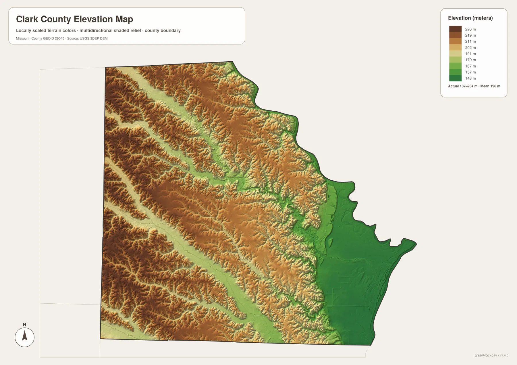
Because the elevation map contains little road or city labeling, it works best beside the general county map. Locate Kahoka, Wayland, Alexandria, and Wyaconda first, then transfer those positions to the colored relief. Alexandria’s low eastern setting contrasts strongly with the rolling land around the western side, while the Fox River valley provides a recognizable low corridor north of Kahoka. This side-by-side method keeps the color scale tied to real places.
Which Clark County map should you use?
Choose the general county map for orientation. It combines Kahoka, Wayland, Alexandria, Wyaconda, Revere, St. Francisville, numbered highways, streams, and the county outline in one view. U.S. 136 and Route 1 establish a simple coordinate system around Kahoka, while U.S. 61 provides another strong north-south reference in the east. This is the best first map when the question involves a road, community, or county boundary.
Use the ranked city map when the goal is a clean explanation of settlement. It highlights the six major communities without the visual weight of every road and stream. Use the terrain-and-water map for Fox River, Little Fox River, Wyaconda River, Little Wyaconda River, tributary valleys, and the eastern river plain. Choose the elevation map when the main question is height or relief, especially the contrast between western uplands and the low Mississippi side.
The download archive contains the original high-resolution JPG versions of all four maps shown on this page. Each image is 3638 by 2572 pixels, providing more room to enlarge highway shields, place labels, stream names, and shaded relief than the embedded WebP previews. The files are suitable for general reference, classroom material, print layouts, and presentations, but they do not replace legal surveys, parcel records, live navigation, official flood maps, or engineering-grade elevation data.
For a complete reading, start at Kahoka on the general map and trace U.S. 136 from Luray through Wayland toward Alexandria. Then check the city map to fix the six principal communities in memory. Move to the water map and follow Fox River in the north and the Wyaconda system in the south. Finish with the elevation map, where the same valleys appear as green low corridors and the eastern river plain opens out toward the Mississippi. That sequence turns four separate images into one connected view of Clark County.
Frequently Asked Questions
Which roads are the easiest anchors for locating Kahoka and the rest of Clark County?
Start with U.S. 136 and Missouri Route 1. They meet at Kahoka and make the central part of the county easy to orient. U.S. 136 leads west toward Medill and Luray and east toward Wayland and Alexandria. In the eastern part of the county, add U.S. 61 as another north-south reference close to Wayland and the Mississippi River side.
How can I tell Fox River from the Wyaconda River system?
Fox River is the prominent northern-central river, running from the northwest toward the southeast with Little Fox River and many tributaries joining it. Wyaconda River and Little Wyaconda River lie farther south and extend across the southern half of the county. Comparing the water map with the elevation map helps because each system appears again as a distinct low green valley.
Does the green area on the elevation map show the official floodplain?
No. Green only identifies relatively lower elevation within Clark County’s local color scale. The broad eastern lowlands and stream valleys therefore appear green, but flood risk depends on river stages, levees, rainfall, mapped flood zones, drainage, and other conditions. Use current FEMA, USGS, and local information for property or safety decisions.
Map File Information
The ZIP contains the original high-resolution JPG files for the general county map, ranked city map, terrain-and-water map, and elevation map shown in this article. The originals are larger than the on-page WebP previews and make highway numbers, place labels, stream names, and shaded relief easier to inspect.
- Included Files: 4 maps
- File Type: JPG
Related Maps
Sources and References
- Clark County Missouri – About: official county information on location, river boundaries, terrain, and history.
- City of Kahoka – About Us: official information about the Clark County seat.
- U.S. Census Bureau TIGER/Line Shapefiles: official county-boundary and transportation geography.
- USGS National Hydrography: official river, stream, lake, and related hydrography data.
- USGS 3D Elevation Program: official elevation and terrain-surface data.
Green Map creates custom-edited map images using open geographic data sources such as geoBoundaries, Natural Earth, OpenStreetMap, and government open data. These maps are edited visual materials, not raw data files, and are provided for education, documents, presentations, and graphic reference.