Cass County sits along Missouri’s western side, immediately south of the Kansas City area, and the maps show a county with two noticeably different settings. Belton, Raymore, Pleasant Hill, and Lake Winnebago cluster in the north, while Harrisonville occupies a more central position along the I-49 and U.S. 71 corridor. Farther south, the towns become more widely spaced and the landscape opens into a network of tributary valleys tied to the South Grand River. The high-resolution JPG versions of all the maps used here can be downloaded together in the ZIP box near the end of the article. High-resolution map files are available for download in the section below.
The most useful way to orient yourself is to begin with the north-to-south pattern. Belton and Raymore lie close together near the northern edge, with Pleasant Hill farther east and Peculiar just to the south of the northern cluster. Harrisonville is separated from those cities by a broader rural area and acts as the central reference point for roads running toward Archie, Garden City, Drexel, and the southern county line. Creeks become increasingly visible away from the built-up north, especially where the terrain drops toward the South Grand River system.
Cass County’s official history page identifies Harrisonville as the county seat and notes that the county was organized in 1835, originally under a different name before becoming Cass County in 1849. That history helps explain why Harrisonville remains an important administrative reference even though the northern part of the county now contains several of the larger communities highlighted on the city-distribution map.
Table of Contents
From the Belton–Raymore cluster to Harrisonville’s highway junction
The general county map immediately emphasizes the concentration of places in the north. Belton sits near the northwest, Raymore is just to its east, and Pleasant Hill occupies the northeastern side. Lake Winnebago appears close to the northern boundary, while Lee’s Summit is labeled just beyond the county line. Together these names make it easy to see how the northern edge of Cass County relates to the broader Kansas City metropolitan area without turning the map into a detailed urban street plan.
Several major routes help organize that northern half. Route 58 runs east-west, and Route 291 provides a clear north-south reference near the northeastern communities. The more prominent north-south corridor descends from the Belton and Raymore area through Peculiar and toward Harrisonville, where I-49 and U.S. 71 are labeled. Harrisonville also connects with Route 2 and other county roads, making it the clearest central road hub on the map.
The map includes Cass Regional Medical Center near Harrisonville and Lawrence Smith Memorial Airport a short distance away. Those labels give the road network practical context: the county map is not only showing municipal names but also a few landmarks that help readers recognize the Harrisonville area. Continuing south, the same north-south corridor reaches toward Archie, while Route 7 heads through the southeastern side near Garden City.
Western and southern places are more spread out. Cleveland appears near the western edge, Freeman lies southwest of Harrisonville, and Drexel is near the southwestern corner. Garden City is separated from Harrisonville to the southeast. The greater distance between these places, combined with the many small stream lines crossing the map, gives the central and southern portions a different character from the closely spaced northern municipalities.
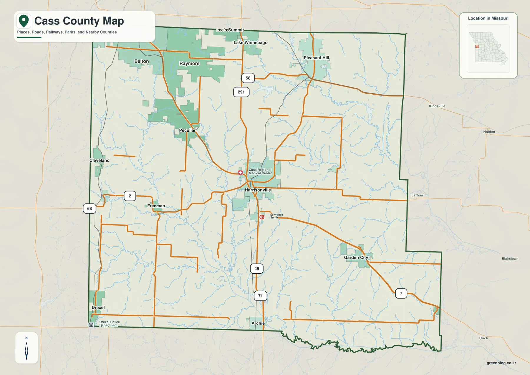
This map is best used for orientation rather than turn-by-turn navigation. It shows the relative position of towns, county boundaries, major road numbers, and selected landmarks, but it does not provide current construction closures, lane details, speed limits, or live traffic. For a trip, use the county map to understand the overall layout, then confirm the final route with current transportation information.
What the six-city index reveals about settlement in northern Cass County
The city-distribution graphic simplifies the county by highlighting six communities instead of labeling every place. Belton is marked as number 1, Raymore as 2, Harrisonville as 3, Pleasant Hill as 4, Peculiar as 5, and Lake Winnebago as 6. A matching city index appears below the map, allowing readers to compare the ranked set without searching through the full road map.
The geographic pattern is more informative than the numbers themselves. Belton and Raymore are close together near the northwest, while Pleasant Hill and Lake Winnebago also fall within the northern half. Peculiar forms a step south from the Belton–Raymore cluster, and Harrisonville sits farther down in the center. This creates a clear contrast between a more concentrated northern group and a central county seat that is geographically separated from it.
Neighboring county labels add another layer of context. Jackson County appears along the north, Johnson County to the east, Henry County farther southeast, and Bates County to the west. The northern communities sit close to the Jackson County side, whereas Harrisonville and the southern landscape extend well away from that boundary. This makes the city graphic useful for explaining both local settlement and the county’s position within western Missouri.
The index includes numeric values beside the city names, but the preview does not state a reference year prominently enough to treat those figures as a current census ranking. For that reason, this article uses the graphic as a supplied ranked-city index rather than asserting that it is the latest official population table. Anyone needing current population figures should verify them separately with the U.S. Census Bureau.
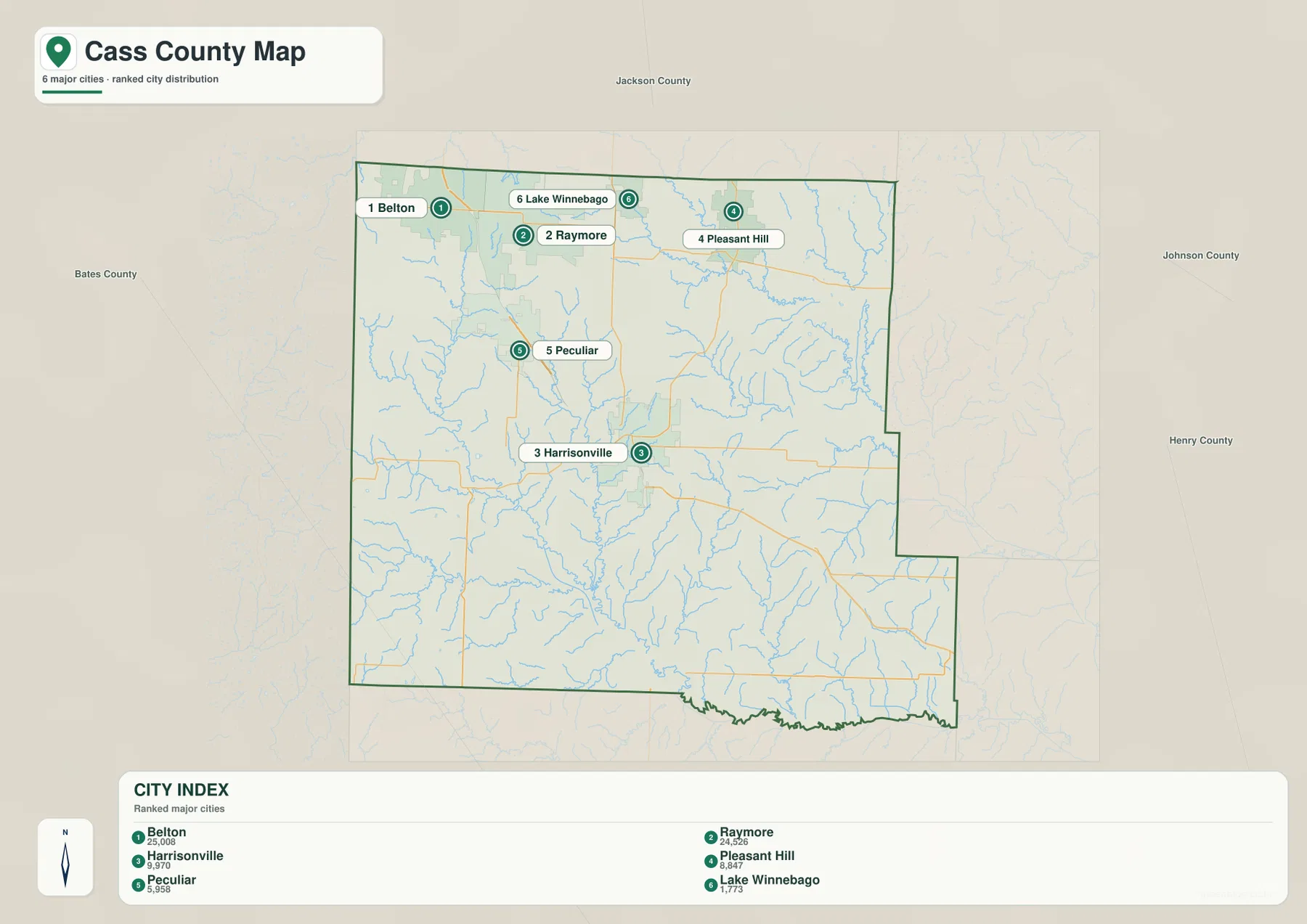
For a presentation or a quick regional overview, this simplified city map is often easier to read than the full county map because the road network has been reduced. If the goal is to explain how Harrisonville connects to Garden City, Drexel, or the state routes, however, the detailed county map is the better companion. The two maps answer different questions and work best when used together.
South Grand River branches, lakes, and the low corridors between the ridges
The terrain-and-water map changes the emphasis from towns to drainage. In the southern half, the South Grand River system is the dominant feature. Labels identify the East Fork South Grand River, South Fork South Grand River, Old Channel South Grand River, and South Grand River itself. These channels occupy broad low routes through the center and southwest before continuing toward the southern edge of the county.
Big Creek is a prominent named stream in the northeastern side, and smaller creek lines branch across much of the county. The density of these tributaries is important because it shows that Cass County is not a featureless plain. Even where the relief is moderate, water has cut a repeating pattern of narrow valleys that becomes much easier to recognize when the shaded terrain is viewed behind the blue drainage lines.
Several lakes provide additional reference points. Lake Winnebago and Pleasant Hill Lake are in the northern area, with Baldwin Lake farther south. Silver Lake appears toward the northwest, Harrisonville City Lake and another City Lake are near the central part of the county, and Lake Annette lies toward the southwest. These water bodies are smaller than the main river system, but they help connect familiar place names with the surrounding drainage.
A useful feature of this map is the way the streams and relief reinforce one another. Around Harrisonville, small tributaries descend into lower channels, and farther south the East Fork and South Fork occupy longer low corridors. Near Lake Annette, drainage trends toward the South Fork system. The resulting picture helps explain why the southern county looks more dissected by waterways than the more urbanized northern strip.
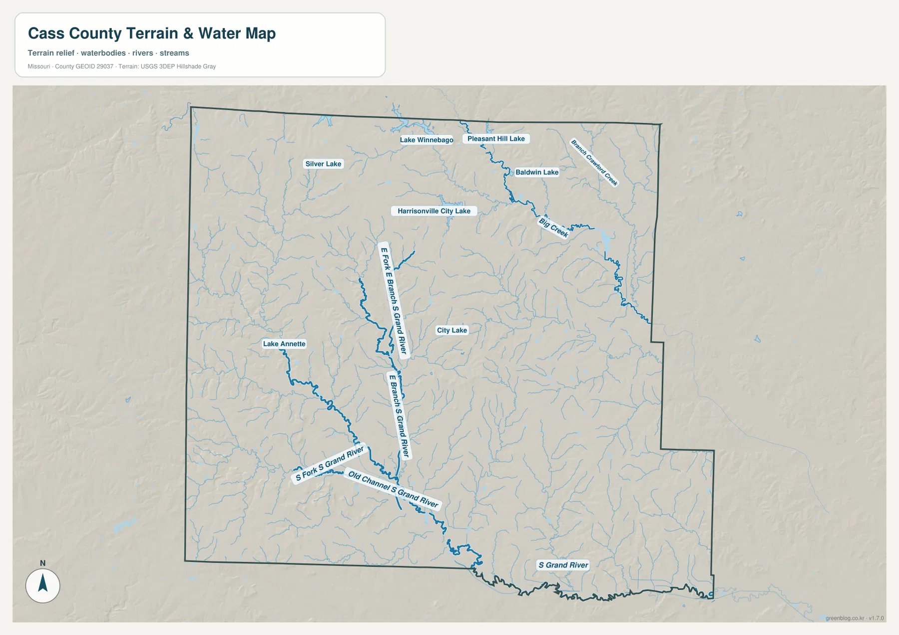
This water map should not be treated as a flood-risk, navigation, property-boundary, or regulatory product. It is designed to show the location of streams and water bodies in relation to the terrain. Flood status, water levels, legal shoreline questions, and boating or fishing rules can change or depend on separate official datasets, so those uses require current information from USGS, FEMA, state agencies, or local authorities.
Higher ground in the northwest and lower valleys toward the southern river system
The elevation map gives Cass County a very different visual appearance. The stated elevation range is approximately 226 to 347 meters, with a mean near 278 meters. The higher colors are strongest across the northwest and portions of the western edge, while lower green corridors become more continuous through the center and south. The difference between the mapped minimum and maximum is roughly 121 meters.
Northwestern Cass County contains closely spaced ridges and short valleys. This is visible even around the broader Belton–Raymore side of the county, although the urban map does not emphasize relief. Moving toward Harrisonville and then south, the lower drainage corridors become easier to trace. The tributaries associated with the South Grand River frequently coincide with the green bands on the elevation surface.
The eastern and southeastern portions are not uniformly low. Narrow ridges and branching valleys continue around the Garden City side, and the terrain varies over short distances. The important pattern is not a simple west-high/east-low division. Instead, higher interfluves are repeatedly separated by lower creek valleys, while the broadest low corridors connect toward the southern river system.
The color ramp is scaled to make local differences inside Cass County easy to see. Brown does not mean high mountains, and green does not automatically indicate wetlands or mapped floodplain. For surveying, engineering, drainage design, construction, or any task that requires precise elevation, the appropriate source is the underlying USGS 3D Elevation Program data or a professional site survey rather than this generalized visualization.
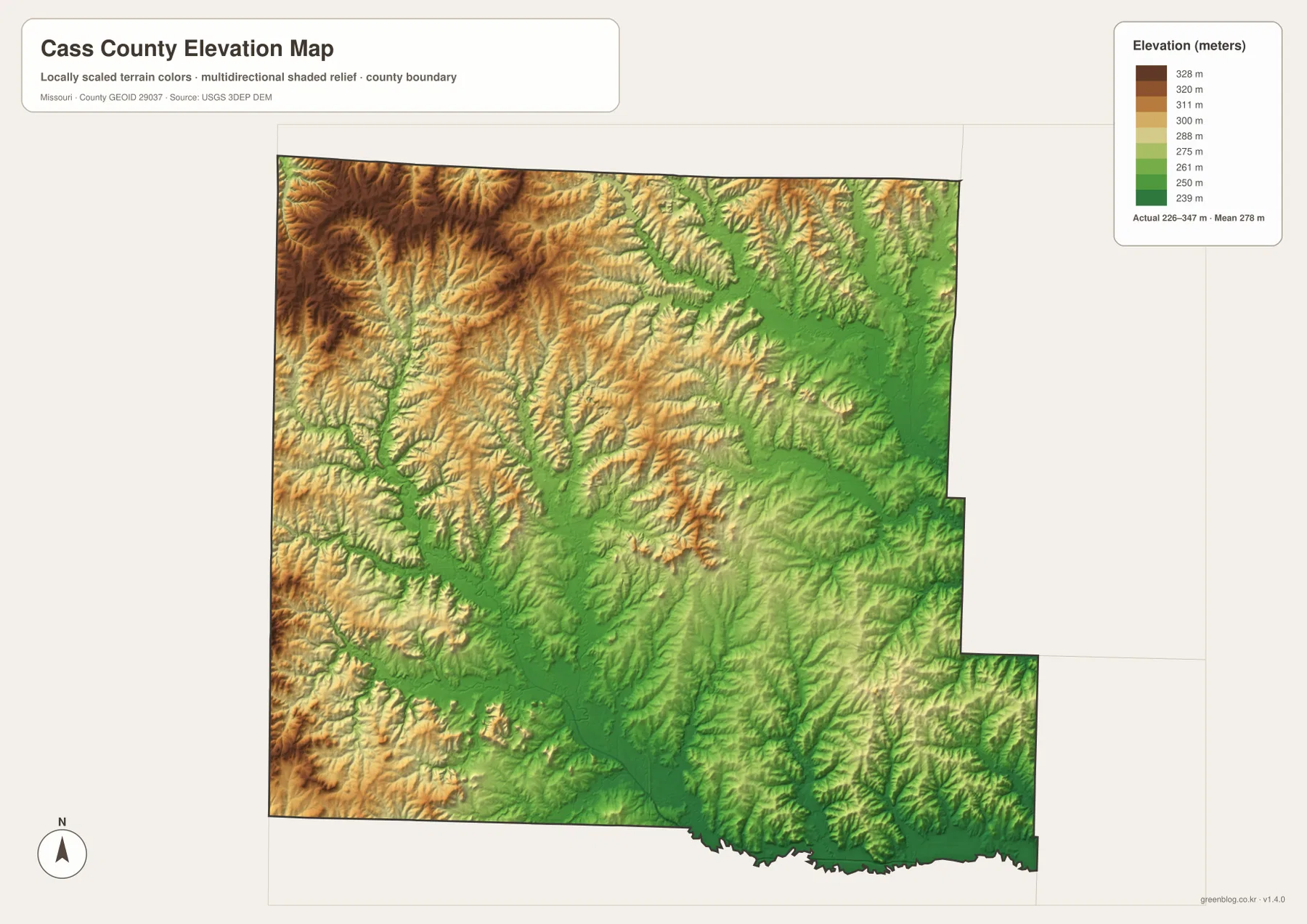
Comparing the elevation and road maps adds useful context to travel routes. The I-49 and U.S. 71 corridor passes through Harrisonville and continues south across terrain that is cut by many tributaries, while smaller roads often cross or follow local valleys. The map can suggest why a route bends or why two nearby points may not be connected by a straight road, but it is not detailed enough to calculate road grades or driving difficulty.
Choosing the right Cass County map and using the downloadable JPG set
Choose the general county map when place names and road numbers matter most. It combines Belton, Raymore, Pleasant Hill, Peculiar, Harrisonville, Garden City, Archie, Drexel, and other labels with the principal routes and the county boundary. This version is the strongest starting point for explaining how the northern city cluster connects with Harrisonville and the more widely spaced southern communities.
The city-distribution version is better when the goal is to compare the highlighted communities without the visual weight of the road network. It makes the northward concentration of Belton, Raymore, Pleasant Hill, and Lake Winnebago especially clear, while Harrisonville remains distinct in the center. For current population statistics, pair it with official census data rather than assuming the map’s city index is a current demographic table.
Use the terrain-and-water map to follow the South Grand River branches, Big Creek, and the named lakes. It is particularly useful for connecting drainage with the shaded valleys that cross central and southern Cass County. The elevation map reduces the same landscape to a clearer high-versus-low comparison, making the higher northwest and lower river corridors easier to distinguish at a glance.
The downloadable ZIP contains the four original JPG maps shown in this article. Each file is 3638 by 2572 pixels, so labels, road numbers, stream names, and terrain shading can be viewed at a larger size than in the web-optimized images. The set is well suited to general reference, classroom work, printing, and presentations, but it should not replace legal boundary records, parcel data, engineering surveys, current road conditions, or official flood mapping.
For the clearest overall picture, start with the city distribution to understand where the largest highlighted communities sit, move to the road map to connect those places, and then use the water and elevation maps to explain the physical landscape beneath them. That sequence makes the contrast between the northern urban concentration, central Harrisonville, and the South Grand River valleys much easier to understand.
Frequently Asked Questions
How are Harrisonville and the Belton–Raymore area positioned differently within Cass County?
Belton and Raymore are close together in the northern part of the county near the Jackson County side. Harrisonville lies farther south in the central area along the I-49 and U.S. 71 corridor. This separation is one of the clearest geographic patterns in the maps: a concentrated northern group of communities and a distinct central county seat that connects to the more rural south.
Do the numbers 1 through 6 on the city map represent a current official population ranking?
The supplied graphic presents Belton, Raymore, Harrisonville, Pleasant Hill, Peculiar, and Lake Winnebago as a ranked city index, but the preview does not clearly state the reference year for the accompanying figures. It is therefore safest to use the map for the relative placement of those cities and verify any current population comparison with the U.S. Census Bureau.
Does the green color on the elevation map show official flood zones?
No. Green represents lower elevation within the locally scaled Cass County surface, which is why many stream valleys and South Grand River corridors appear green. Official flood risk depends on additional hydrologic and regulatory information. Use FEMA, USGS, and local government sources for floodplain or current water-level questions.
Map File Information
The ZIP contains the high-resolution JPG originals for the county map, city-distribution map, terrain-and-water map, and elevation map shown in this article. The larger files make road numbers, place names, streams, lakes, and relief easier to inspect.
- Included Files: 4 maps
- File Type: JPG
Related Maps
Sources and reference links
- Cass County, Missouri – County History: official background on the county’s organization, name, and Harrisonville as the county seat.
- U.S. Census Bureau TIGER/Line Shapefiles: official geographic data for county boundaries and roads.
- USGS National Hydrography: reference data for rivers, streams, lakes, and other hydrographic features.
- USGS 3D Elevation Program: elevation and terrain-surface data.
Green Map creates custom-edited map images using open geographic data sources such as geoBoundaries, Natural Earth, OpenStreetMap, and government open data. These maps are edited visual materials, not raw data files, and are provided for education, documents, presentations, and graphic reference.