Callaway County sits in central Missouri with Fulton near its everyday geographic center, Kingdom City on the major east-west interstate corridor, and a long Missouri River edge along the south. U.S. 54 links Kingdom City, Fulton, and the Jefferson City side of the county, while smaller communities such as Auxvasse, New Bloomfield, Holts Summit, and Mokane spread across very different parts of the landscape. This page brings those roads and settlements together with the county’s stream network and relief. The four maps shown below are also available as original high-resolution JPG files in one downloadable ZIP.
The county changes noticeably from north to south. Higher ridges dominate much of the northwest and north-central interior, then stream valleys cut more deeply toward the middle and eastern sections. Along the Missouri River, broad low ground forms a distinctly lower southern margin. That contrast is not obvious on a simple road map, but it becomes clear when the terrain-and-water sheet is compared with the elevation surface. Middle River and Auxvasse Creek are especially useful natural reference lines because both occupy low corridors that connect the interior uplands with the river side of the county.
Fulton is the county seat and the most prominent community on the supplied ranked-city map. Kingdom City is much smaller in that ranking, yet its road position is unusually important because Interstate 70 meets U.S. 54 there. Holts Summit occupies the southwest near the Missouri River and Jefferson City, while Mokane sits farther downstream on the southeast side. The maps therefore show several different kinds of importance at once: population concentration, county government, highway access, river proximity, and physical terrain.
Table of Contents
Fulton and Kingdom City Organize the County’s Main Road Pattern
For quick orientation, Fulton is the easiest place to start. It lies a little west of the county’s center and sits on the north-south U.S. 54 corridor between Kingdom City and the Missouri River side of the county. Missouri Department of Transportation material identifies the I-70/U.S. 54 interchange at Kingdom City as a major transportation connection in Callaway County. That junction gives the northern part of the county a clear east-west reference, while U.S. 54 provides the main visual link south through Fulton toward Holts Summit and Jefferson City.
Interstate 70 and U.S. 40 cross the northern part of the map through the Kingdom City area. From there, U.S. 54 turns the eye south toward Fulton, which makes the county’s road structure easy to understand even before smaller roads are considered. Auxvasse lies north of Fulton but east of the U.S. 54 line, so it belongs to the northern cluster without sitting directly on the same north-south axis. New Bloomfield and Holts Summit, by contrast, are part of the southern sequence leading toward the river and the Jefferson City area.
The southeastern edge has a different road character. Route 94 stays close to the Missouri River corridor and helps locate Mokane and Tebbetts, while the river itself curves across the bottom of the map. Holts Summit appears near the large southwestern bend, and Jefferson City is shown just outside the county as a useful external landmark. Reading the map this way separates the county into a northern interstate zone, a Fulton-centered interior, and a river-oriented south rather than treating every road as equally important.
Neighboring counties also help frame the location. Boone County lies to the west, Audrain County to the north, Montgomery County to the east, and Cole, Osage, and Gasconade counties occupy the Missouri River side to the south and southeast. The map is designed for general geographic reference rather than live travel operations, so temporary construction, closures, detours, and local road restrictions may not appear. Current driving decisions should always be checked against live transportation information.
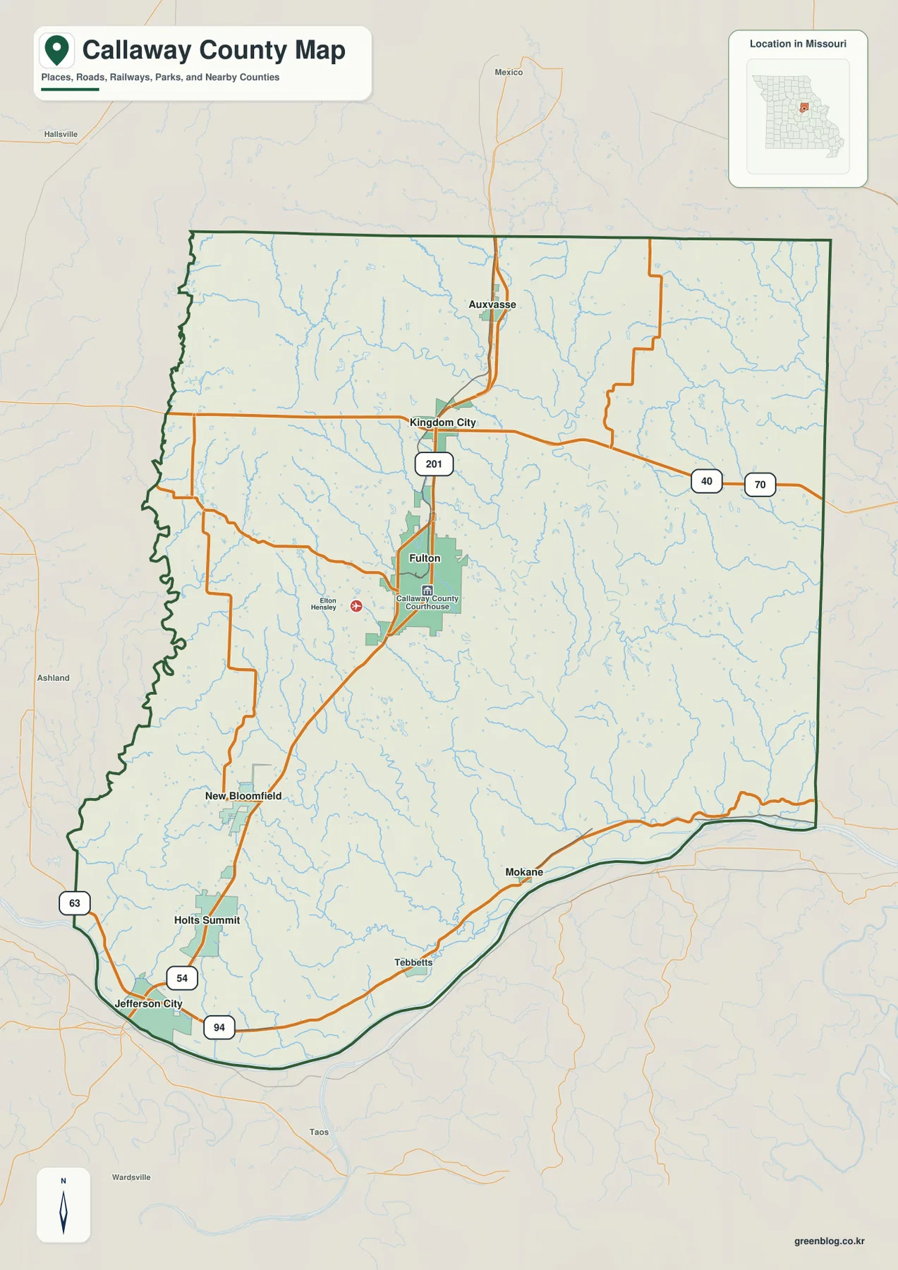
A practical reading order is to find Kingdom City first, follow U.S. 54 south to Fulton, then continue toward New Bloomfield, Holts Summit, and the Missouri River. Auxvasse can then be placed northeast of the main Fulton corridor, while Mokane marks the lower southeast. This approach makes the county understandable without memorizing every numbered route and provides a useful framework for the city, water, and elevation maps that follow.
Six Major Communities Spread from the I-70 Corridor to the Missouri River
The ranked city-distribution map removes most road detail and emphasizes six selected communities. Fulton is ranked first on the supplied sheet, followed by Holts Summit, Auxvasse, New Bloomfield, Mokane, and Kingdom City. Numeric values are printed beside the city list as part of the map, but they should be treated as the data used for this particular cartographic reference rather than as a promise of the latest official population estimate. Census figures and municipal information can change over time.
Fulton occupies the strongest central position. Holts Summit sits far to the southwest near the Missouri River, and New Bloomfield lies farther north and east of it, creating a loose chain across the southern half of the county. Auxvasse is well north of Fulton, while Kingdom City appears closer to the north-central transportation corridor. Mokane is separated from all of them on the southeast river side. The result is a distributed settlement pattern rather than a single row of towns along one highway.
The ranking is also a reminder that population size and transportation significance are not the same thing. Kingdom City is the smallest of the six on this map, yet the I-70/U.S. 54 interchange makes it an important orientation point for anyone crossing central Missouri. Mokane is also small in the ranking, but its position near the Missouri River makes it useful when reading the water and terrain maps. Fulton combines several roles at once: it is the largest selected community, the county seat, and the most obvious interior road hub.
This city sheet is not a connector-distance map. It does not draw lines between towns or provide driving mileage. Instead, the numbered markers are designed to compare rank and location, making the sheet useful for presentations, county overviews, and quick north-south or east-west orientation. A traveler looking for actual routes should return to the general county map, where the I-70, U.S. 54, and Route 94 corridors supply the missing road context.
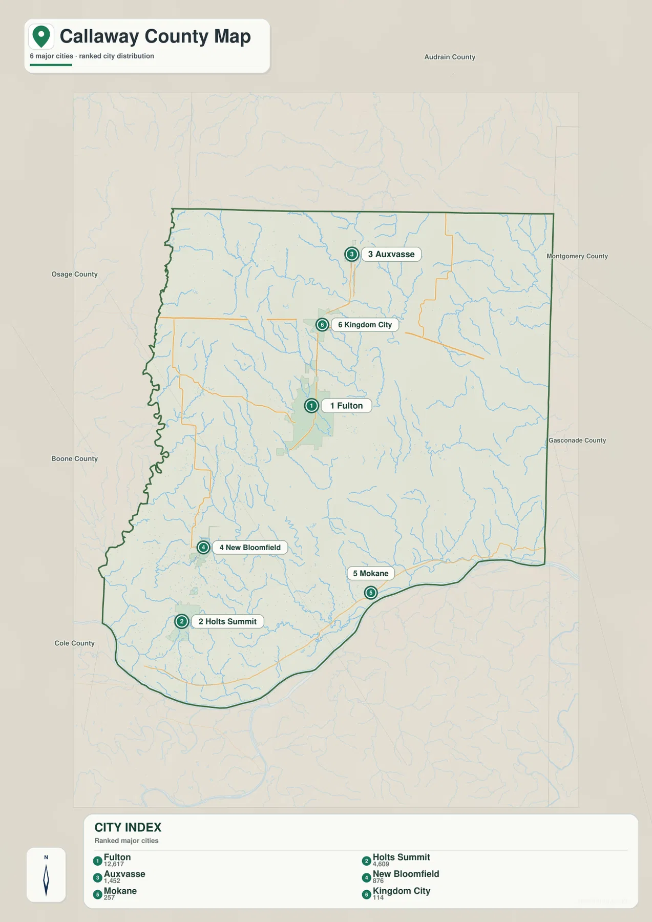
The surrounding county labels add another layer of orientation. Boone County is on the west, Audrain County on the north, Montgomery County on the east, and the Missouri River separates Callaway from counties to the south. That setting helps explain why the selected communities do not form one compact cluster. Some relate most directly to the interstate corridor, some to Fulton, and others to the river-side roads and lowlands.
Middle River and Auxvasse Creek Drain toward a Broad Missouri River Lowland
The terrain-and-water map shifts attention away from highways and toward drainage. The Missouri River is the dominant feature along the southern edge, curving around a broad lowland and collecting water from numerous interior creeks. On the simpler road map the river can look like little more than a boundary line. Shaded terrain makes its physical influence much clearer because the southern margin is visibly lower and wider than many of the narrow interior valleys.
Middle River is one of the strongest internal drainage features. It winds through the western and central portions of the county before reaching the lower southern terrain. Stinson Creek and Hillers Creek occupy nearby western valleys, while Cedar Creek appears toward the southwest. These channels split the uplands into repeated ridges and hollows rather than following a neat set of parallel lines. The pattern is especially visible where small tributaries descend from the higher northwest toward the Middle River corridor.
Auxvasse Creek provides the major counterpart on the eastern side. It runs through a long low corridor with tributaries entering from both directions, and several named lakes appear nearby, including Leisure Lake, Lake Lochaweeno, Canyon Lake, and Lake Thunderbird. Farther north, South Fork Salt River crosses the upper part of the county, while Loutre River appears near the northeastern edge. These northern streams belong to a different drainage setting from the Missouri River tributaries farther south, which gives the county a more varied hydrographic pattern than a single south-flowing system would suggest.
Several smaller water bodies help locate particular areas. Little Dixie Lake appears in the western part of the county, Glover Spring Lake is closer to the center, and Lake My-Kee lies in the southwest. None is comparable in scale to the Missouri River, but each works as a local landmark when smaller roads and communities are difficult to identify. Their positions are also easier to understand when the surrounding shaded relief is visible, because ridges and low corridors explain why these water features occupy particular pockets of the landscape.
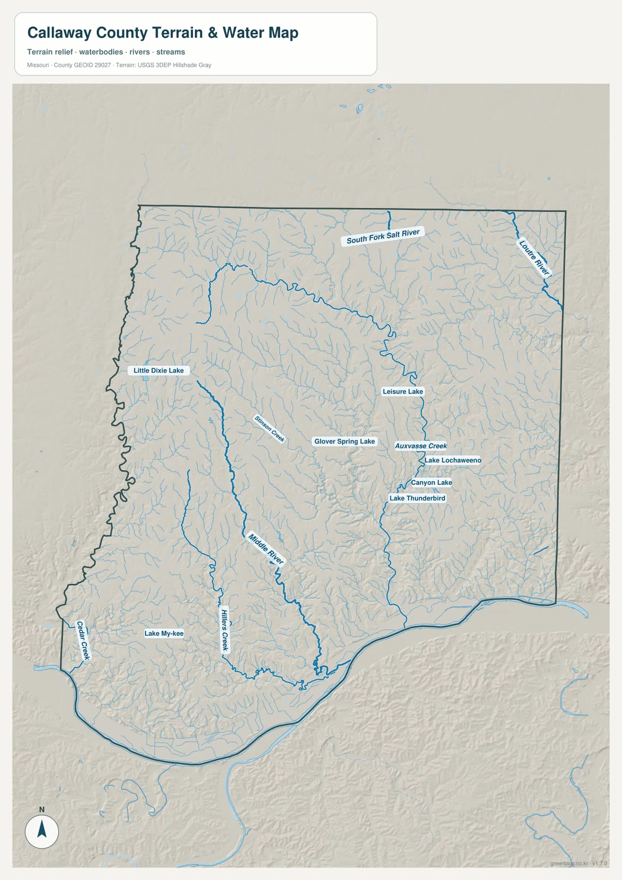
This is a geographic water-reference map, not a regulatory or safety product. Blue lines do not represent FEMA flood zones, legal water boundaries, real-time stage information, navigation channels, or parcel limits. The Missouri River and large creek valleys may coincide with areas of flood concern, but site-specific risk depends on official flood studies, levees, rainfall, channel conditions, and current local information. Use FEMA and county sources for property, insurance, development, or emergency decisions.
Higher Northwest Ridges Drop toward the Southern River Bottoms
The elevation map gives the clearest view of Callaway County’s physical contrast. Its legend shows an actual range of roughly 155 to 293 meters with a mean near 232 meters. Browns and oranges dominate much of the northwest and north-central uplands, while greens become increasingly common in major creek valleys and along the Missouri River. The change is strongest at the southern edge, where a wide dark-green band follows the river and marks the county’s lowest terrain.
A relief difference of about 138 meters is not mountainous on a national scale, but it is substantial enough to shape a county landscape. Middle River and Auxvasse Creek cut long lower corridors through the warmer-colored uplands. Smaller tributaries create narrow green fingers extending into the ridges, especially in the western half. When the water and elevation maps are compared, the close relationship between drainage and relief becomes immediately visible: the named streams occupy the same low pathways highlighted by the elevation colors.
The northwest is not a single flat high plateau. It contains repeated ridges separated by short stream valleys, producing a textured surface even where the overall elevation remains high. Moving south, those small valleys merge into larger low corridors. Hillers Creek and Cedar Creek contribute to the southwestern pattern, while Middle River opens toward the central-southern lowlands. On the east, Auxvasse Creek performs a similar role before reaching the Missouri River side.
The map uses a locally scaled color range, so brown should not be interpreted as high mountain terrain compared with Missouri as a whole, and green should not be interpreted as wetland or flood-zone classification. It is a county-scale comparison of relative height. The generalized surface is well suited to understanding ridges, valleys, and river bottoms, but survey-grade elevations, engineering design, drainage calculations, and construction decisions require detailed USGS data or professional field measurements.
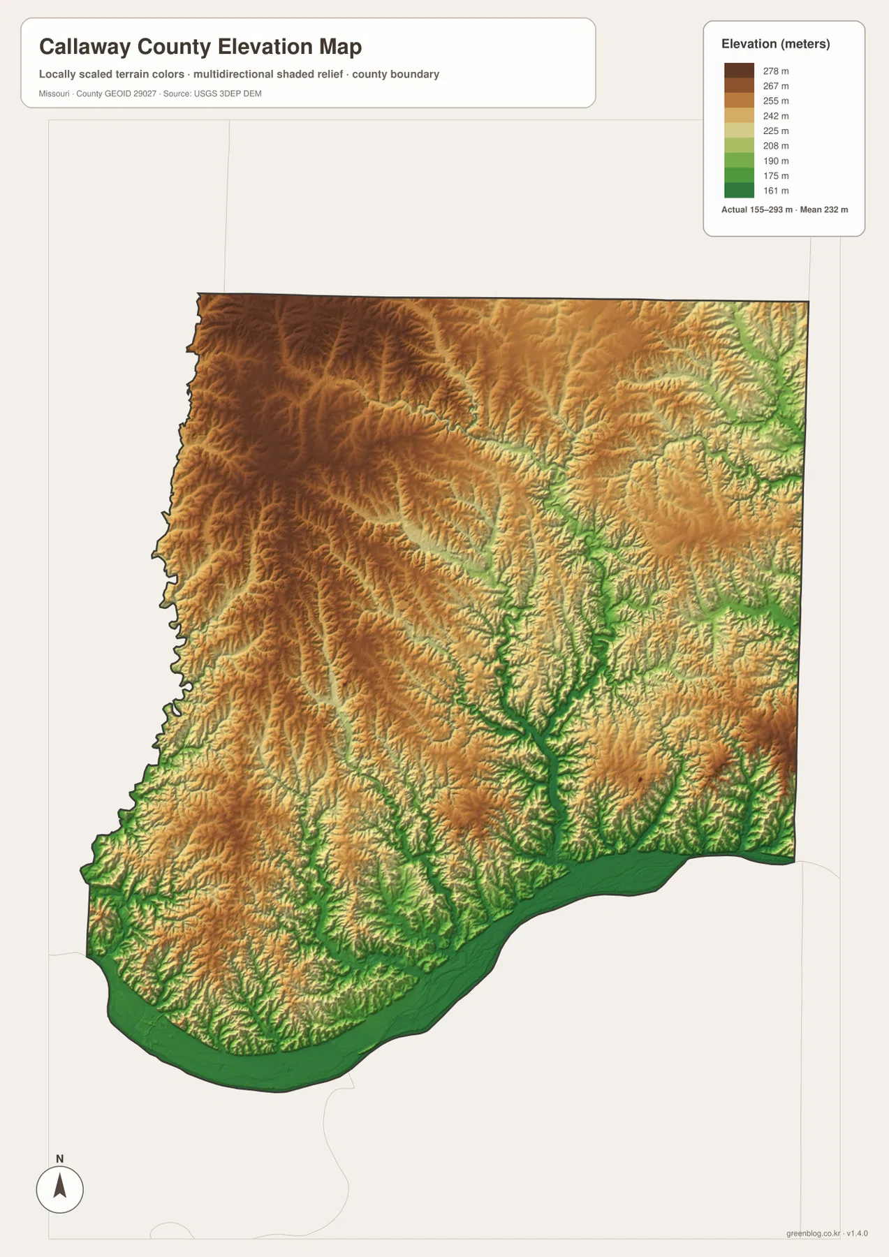
Settlement positions become more meaningful against this terrain. Fulton stands inland rather than on the lowest river bottom, while Holts Summit and Mokane are much closer to the southern lowlands. Auxvasse and Kingdom City occupy the generally higher northern side. The city pattern therefore reflects more than distance from one central town; it spans different road corridors, drainage basins, and elevation zones within the same county.
Use the Four Maps as Different Views of the Same County
Start with the general county map when the goal is to locate Fulton, identify the I-70/U.S. 54 junction at Kingdom City, or understand how Holts Summit, New Bloomfield, Auxvasse, and Mokane relate to major roads. The ranked city map is cleaner when road detail would be distracting. It quickly shows that the six selected communities are spread from the north to the Missouri River side rather than concentrated in one compact urban cluster.
For physical geography, the water and elevation sheets work best as a pair. The water map names Middle River, Auxvasse Creek, South Fork Salt River, Loutre River, and several smaller lakes and creeks. The elevation map then shows why those channels occupy their particular paths, with green low corridors cutting through higher uplands. This pairing is especially useful in the west-central interior and along the eastern Auxvasse Creek system, where the drainage pattern is easy to miss on the road map alone.
The on-page WebP images are optimized for viewing in a browser. The ZIP archive contains the same four maps as original 3638-by-2572-pixel JPG files, giving more room to enlarge small stream labels, road numbers, and community names or to prepare printed material. These files are intended for ordinary geographic reference and educational use. They do not replace current official sources for parcels, zoning, legal boundaries, flood insurance, active road closures, or precise elevations.
A concise way to understand Callaway County is to use Fulton and Kingdom City as human-geography anchors, then use the Missouri River, Middle River, and Auxvasse Creek as physical-geography anchors. The higher northern and northwestern ridges sit above a network of interior valleys that eventually opens toward the broad river lowland. Each map highlights a different part of that story, so the best choice depends on whether the reader needs roads, settlement distribution, water, or relief.
Frequently Asked Questions
Why is Kingdom City important on the road map even though it ranks sixth on the city sheet?
The city ranking and the transportation network measure different things. Kingdom City is the smallest of the six selected communities on the supplied ranking, but it sits at the I-70/U.S. 54 interchange identified by the Missouri Department of Transportation. That junction connects east-west interstate travel with the north-south route through Fulton toward Jefferson City, making Kingdom City an important road reference despite its small population.
Does the dark green land along the Missouri River show official flood zones?
No. Green on the elevation map means relatively low ground within the locally scaled Callaway County elevation range. It is not a FEMA flood-zone symbol. River bottoms and creek valleys often appear green because they are lower than surrounding ridges, but official flood risk depends on hydrology, levees, rainfall, channel conditions, and regulatory mapping. Use current FEMA and local sources for property or safety decisions.
Are the six numbered communities a complete or permanently current population ranking?
The ranked city map is a convenient comparison of Fulton, Holts Summit, Auxvasse, New Bloomfield, Mokane, and Kingdom City using the data selected for this map package. It does not list every settlement, and population figures can change with new estimates or census releases. For the latest official counts or municipal status, check the U.S. Census Bureau and the relevant local governments.
Map File Information
The ZIP contains the original high-resolution JPG files for the county map, ranked city-distribution map, terrain-and-water map, and elevation map shown in this article. The originals are larger than the on-page WebP images and are suitable for closer viewing and print preparation.
- Included Files: 4 maps
- File Type: JPG
Related Maps
Sources and References
- Callaway County official website: county government and public-information source for Fulton and Callaway County.
- Missouri Department of Transportation – Kingdom City Interchange: official source for the I-70 and U.S. 54 junction.
- U.S. Census Bureau TIGER/Line Shapefiles: official geographic boundary data.
- USGS National Hydrography: official hydrography information for rivers, streams, and water bodies.
- USGS 3D Elevation Program: official elevation and terrain-surface data.
Green Map creates custom-edited map images using open geographic data sources such as geoBoundaries, Natural Earth, OpenStreetMap, and government open data. These maps are edited visual materials, not raw data files, and are provided for education, documents, presentations, and graphic reference.