Wilkin County occupies a long strip of western Minnesota along the North Dakota border. Breckenridge is the clearest reference point, sitting on the western edge near the meeting of the Red River of the North and the Otter Tail River. Wolverton and Kent lie farther north near the river, Rothsay is near the northeastern side, Foxhome is east of Breckenridge, and Campbell occupies the southern half. This page separates roads and settlements, city distribution, waterways, and elevation into distinct views, and the high-resolution JPG originals can be downloaded together in the ZIP box below. High-resolution map files are available for download in the section below.
The county is easiest to understand from west to east. The Red River of the North creates a winding western boundary, while much of the interior is broad and gently rolling. Near the eastern edge, especially toward Rothsay, the land rises much more sharply. Major tributaries cross that open interior before reaching the Red River, including the Otter Tail River near Breckenridge, the South Branch Buffalo River in the north, and the Rabbit River farther south. The four views together show a county shaped by a low river plain, scattered small towns, and a pronounced rise along the east side.
Table of Contents
Breckenridge anchors the road network on the North Dakota border
On the general map, Breckenridge sits slightly south of the county’s midpoint and directly against the western boundary. Across the Red River is Wahpeton, North Dakota. Within Wilkin County, Breckenridge is the most obvious road junction. U.S. 75 follows the western side northward toward Kent and Wolverton, while Minnesota 9 leaves the Breckenridge area and runs northeast toward Rothsay. Those routes make Breckenridge a practical starting point for understanding how the rest of the county is arranged.
East of Breckenridge, a long road crosses the central part of the county, while another corridor continues south through the Doran and Campbell areas. Near the southern edge, an east–west road reaches toward Nashua. The pattern is sparse compared with a metropolitan county: roads cross broad agricultural areas and connect a small number of widely separated communities rather than forming a continuous urban grid. That spacing is one of the clearest geographic characteristics on the map.
Wolverton and Kent provide two western references north of Breckenridge, both close to the Red River and U.S. 75. Rothsay, by contrast, sits near the eastern boundary in the upper part of the county. The east border is relatively straight, while the west border follows the bends of the river, producing a noticeably uneven county outline. The map is useful for road and settlement orientation, but live closures, construction, and turn-by-turn travel should be checked with current transportation services.
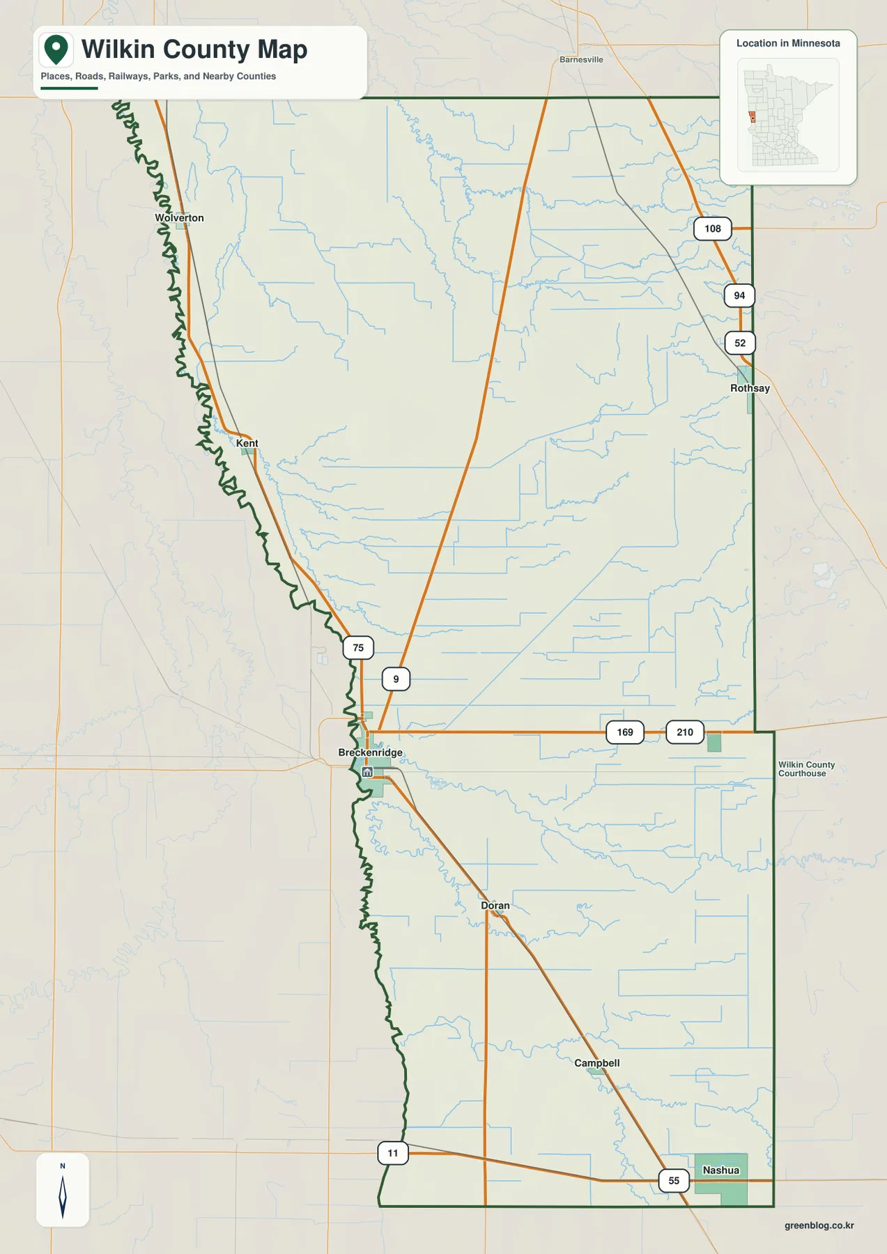
The counties labeled around the map also help place Wilkin County in western Minnesota. Clay County lies to the north, Otter Tail County is to the east, and Traverse County appears to the southwest side of the broader view. North Dakota is immediately across the Red River. Breckenridge therefore sits at a state boundary rather than near the geometric center of its county, an arrangement that strongly influences the road and settlement pattern.
Six highlighted cities show how widely settlements are spaced
The city map highlights six communities with a ranked CITY INDEX: Breckenridge 3,349, Rothsay 454, Campbell 245, Wolverton 145, Foxhome 110, and Kent 70. These are the reference values printed on the supplied map and are useful for comparing the relative size of the highlighted places. They should not replace a current Census table when the latest official population count is required.
Breckenridge is much larger than the other highlighted communities and occupies the west-central edge. Rothsay is separated from it by a broad stretch of the county and sits near the northeast side. Campbell is well to the south, Foxhome lies east of Breckenridge, and Wolverton and Kent form two small river-side points farther north. The visual result is not a single line of cities but a loose set of settlements distributed across a large agricultural county.
Using Breckenridge as the reference makes the arrangement easier to remember. Kent and Wolverton are farther north near the Red River, Rothsay is northeast, Foxhome is east, and Campbell is south. The city map does not draw road connections or report driving distance, so those positions should not be interpreted as travel routes. Its purpose is to show where the six communities sit and how dominant Breckenridge is within the group.
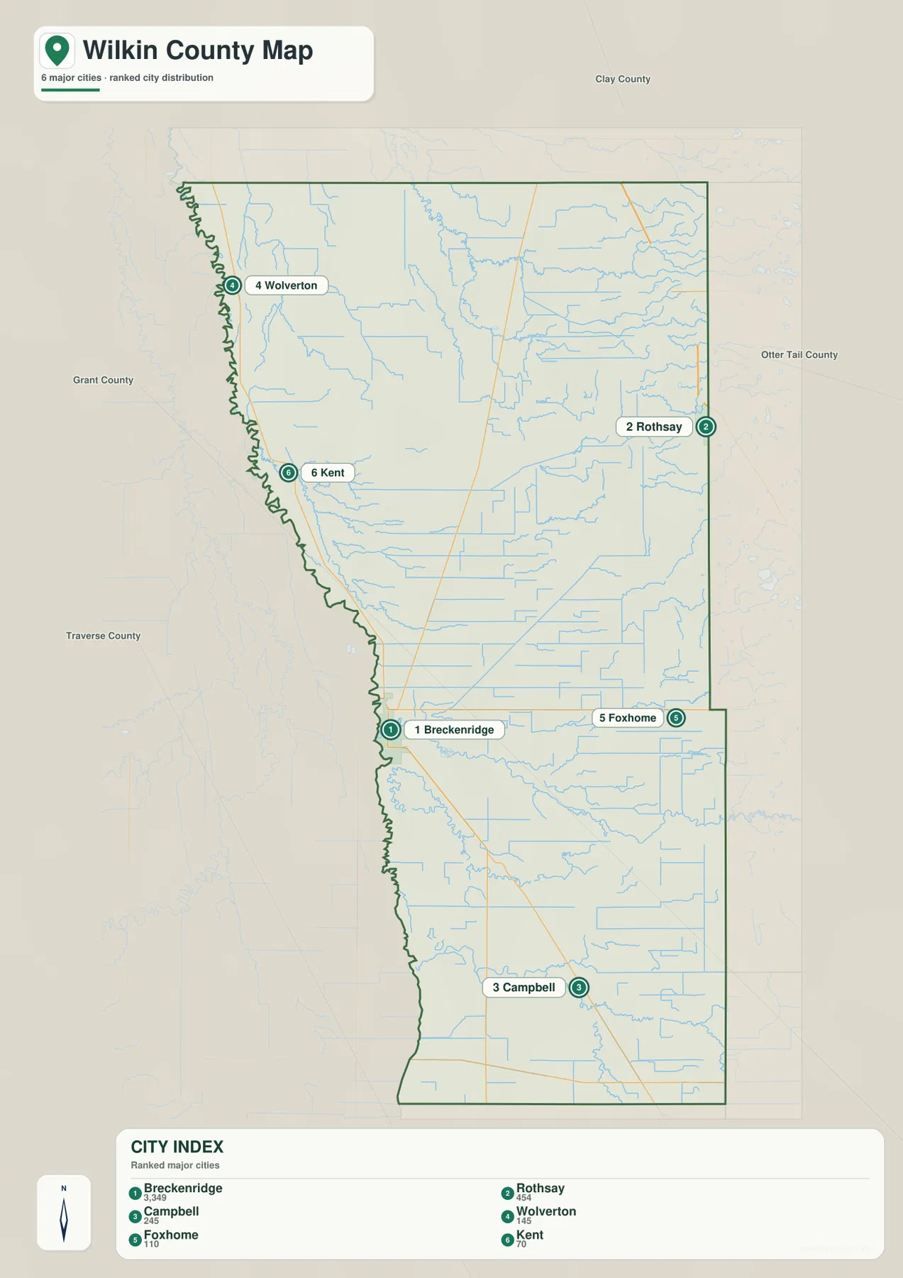
The amount of open space between the markers is just as informative as the ranking. Outside Breckenridge, the county has no large continuous urban belt on this map. Small towns are separated by farmland, drainage lines, and long road segments. Comparing the city view with the general map explains why a few major highways and county roads carry so much of the connection between communities.
The Red River, Otter Tail River, and Rabbit River organize the water map
The Red River of the North is the dominant water feature because it follows almost the entire western edge of Wilkin County. Near Breckenridge, the Otter Tail River approaches from the east and joins the Red River. Breckenridge Lake is also labeled close to this junction. The combination makes the Breckenridge area a strong hydrologic reference in addition to being the county’s main road and settlement center.
In the northern part of the county, the South Branch Buffalo River runs across the interior, with Deerhorn Creek and other smaller channels nearby. Shorter streams and drainage lines also reach westward toward the Red River. The map shows relatively few large lakes; instead, the northern half is characterized by rivers, creeks, and many smaller water lines crossing a broad plain.
Farther south, the Rabbit River crosses much of the county from east to west, and the South Fork Rabbit River appears closer to the southern edge. Between the Otter Tail and Rabbit systems, numerous smaller channels create a dense network even where the terrain looks visually flat. This water-reference map is intended for geographic orientation, not for determining flood zones, water depth, water quality, legal drainage boundaries, or navigation conditions.
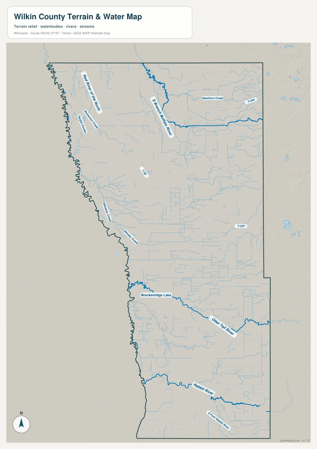
Wilkin County planning documents also discuss waterways, riparian habitat, erosion, stream connectivity, and natural-resource protection in the Red River Basin. Those management topics require more detailed official information than a county-scale reference image can provide. The map here is most useful for seeing where the major named rivers lie in relation to Breckenridge, Rothsay, Campbell, and the county boundary.
Elevation rises from the 273-meter river plain toward the eastern edge
The elevation legend reports an actual range of about 273 to 381 meters with a mean near 303 meters. Darker green dominates the western side, corresponding to the low Red River plain. Much of the central county remains green to yellow-green, indicating gentle relief over a broad area. Near the eastern boundary the colors shift quickly through yellow and tan into brown, revealing a much stronger rise than the road map alone suggests.
The northeastern and eastern margins contain the highest terrain on the supplied elevation view. This is particularly noticeable near the Rothsay side of the county, where brown uplands stand in sharp contrast to the low western plain. Wilkin County therefore should not be treated as uniformly flat: a large part of it is low and gently sloping, but the eastern edge reaches more than 100 meters above the lowest portions of the county.
Breckenridge and the Red River corridor occupy the lower green zone, and the Otter Tail River also follows low ground as it approaches the state line. The Rabbit River crosses another broad low area farther south. The most important countywide contrast, however, is the long transition from the low western border to the higher eastern margin. The mean elevation of 303 meters falls between those two very different settings.
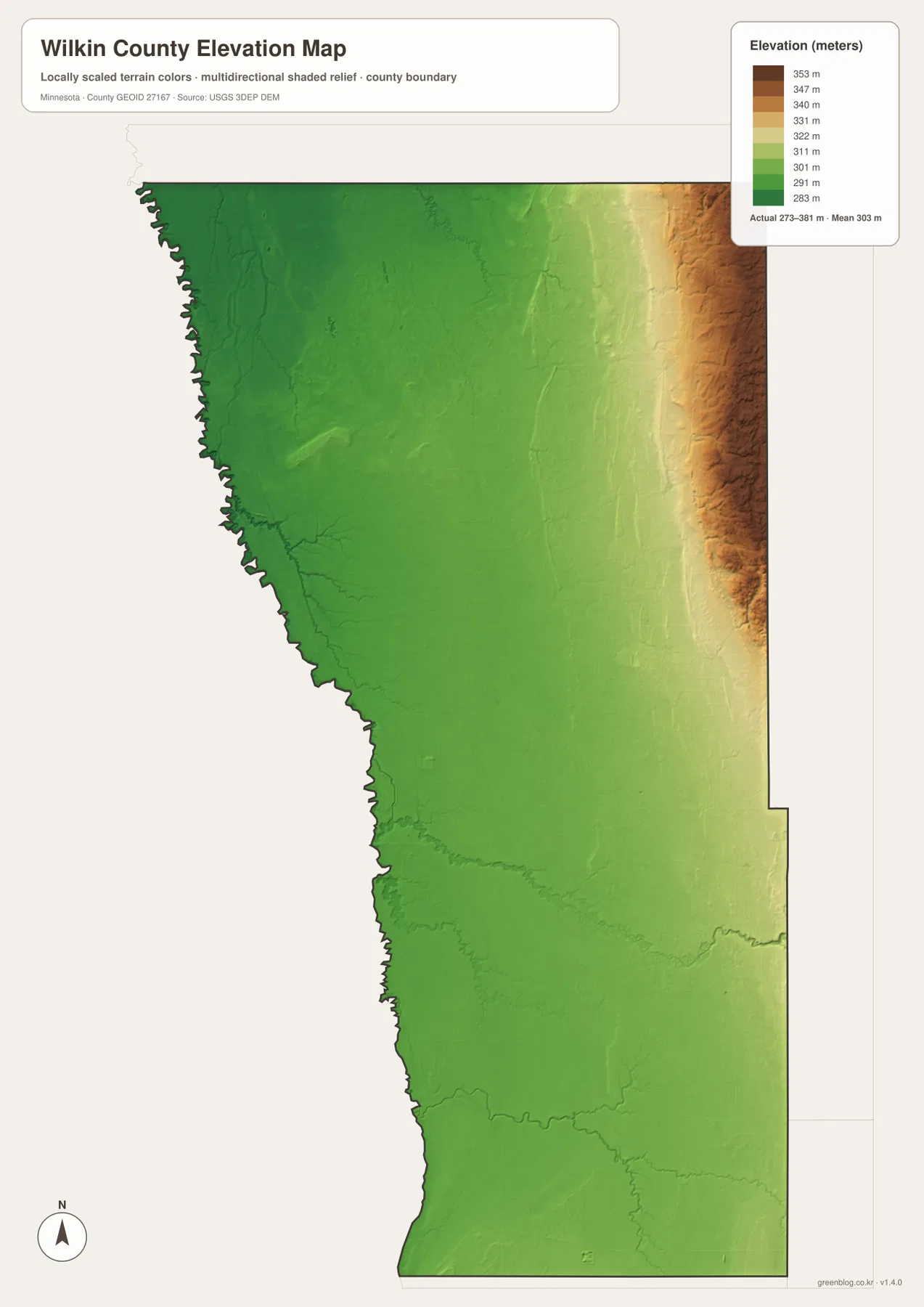
This elevation surface is generalized for county-scale comparison. It should not be used to determine the exact height of a farm field, building site, road grade, drainage structure, or engineering project. Those tasks require source elevation data and field verification. For ordinary map reading, the image is especially useful for understanding why Breckenridge lies in a low river setting while the Rothsay side of the county is visibly higher.
How to combine the four Wilkin County views
A useful first step is to locate Breckenridge and the Red River of the North. From there, follow U.S. 75 north toward Kent and Wolverton, then trace Minnesota 9 northeast toward Rothsay. Add Foxhome east of Breckenridge and Campbell to the south, and the settlement pattern becomes much easier to remember. This approach also makes the county’s long north–south shape and river-defined west border immediately clear.
Next, switch to the water map and locate the Otter Tail River at Breckenridge. Then compare the South Branch Buffalo River in the north with the Rabbit River in the south. On the elevation map, the same western half remains low and green while the eastern side rises sharply. Matching these views shows how waterways cross the plain before reaching the Red River and how the terrain changes toward the eastern boundary.
Use the general map when roads, towns, and county boundaries matter most. The city map is better for comparing the six highlighted communities without extra detail. The water map isolates the main rivers and smaller channels, while the elevation map emphasizes the 273–381 meter range and the east–west relief contrast. Selecting the view that matches the task keeps the information easier to read.
Frequently Asked Questions
Where is Breckenridge within Wilkin County?
Breckenridge sits on the western border a little south of the county midpoint, directly across the Red River of the North from Wahpeton, North Dakota. It is close to the Otter Tail River confluence and is the most prominent road junction on the supplied county map.
What are the main rivers shown in Wilkin County?
The Red River of the North follows the western boundary. The Otter Tail River reaches it near Breckenridge, the South Branch Buffalo River crosses the northern part of the county, and the Rabbit River and South Fork Rabbit River are shown farther south. The map is a location reference rather than a flood or water-quality product.
Where is the highest terrain in Wilkin County?
The elevation map places the highest terrain along the eastern and especially northeastern edge. The legend reports an actual county range of about 273 to 381 meters and a mean near 303 meters. The Red River and Breckenridge area occupy the lowest green part of the map.
Map File Information
The ZIP contains the high-resolution JPG originals of the Wilkin County general map, city map, water map, and elevation map shown on this page.
- Included Files: 4 high-resolution JPG maps
Related Maps
Sources and references
- Wilkin County, Minnesota official website — county and local information
- U.S. Census Bureau TIGER/Line Shapefiles — county boundaries and geographic reference data
- USGS National Hydrography — rivers, streams, and water features
- USGS 3D Elevation Program — elevation and terrain reference data
Green Map creates custom-edited map images using open geographic data sources such as geoBoundaries, Natural Earth, OpenStreetMap, and government open data. These maps are edited visual materials, not raw data files, and are provided for education, documents, presentations, and graphic reference.